Tuesday, July 31, 2012

July 31, 2012 – Overlook to Florence Lake


Title: July 31, 2012 – Overlook to Florence Lake
Trail head: Overlook
Hike Info:
Trail: John Muir Ranch
Destination: Florence lake
Distance: 2.3
Travel Time: 0:33
Moving Time: 0:31
Elevation Rise: 157'
Maximum Elevation: 7,465'


Description:
My morning meditation: Can a Christian ever be alone in this world? For two plus days, we did not see any human besides ourselves and there was hardly a trace of anyone either, except for an occasional duck or if we were fortunate, a little path for a 100 yards. Saw a broken stem of a flower and a couple of foot prints. But you, O Lord, were with us as we wandered. You left signs for us in the beauty we saw. We felt caring in that when we might despair, you should show us the way. Thank you.


Last night read the first chapters of Ephesians. How that makes the heart soar. This morning woke up thinking how hiking is like life. In the cities, we clean up to go to the theater or art museum, which imitates life. But hiking for several days , it is hard work. You sweat, get dirty, strain your muscles. But you see the sights of heaven. Even these are imitations of that which is above. Same way with our walk. We go to church. But it is our life outside of church which is where the real herorics happen. How we live out our lives with others, helping our neighbor on their way to heaven.


Got up around 6. This is a slow day. Just need to make it to the dock by 9—about a mile or a mile and ahlaf. Or we can hike around the lake. Right now, nobody feels strongly about doing the later hike. So down we go. Sherri is leading the way. The trail gets a bit confusing and so we go off on ways unexpected, but still fun. We make it down in plenty of time.


An enjoyable ride across the lake. This is the driver's first time taking the boat, so he is getting directions from his boss—the owner. The lake is low, so the submerged rocks do provide some real challenge to navigation. But we make it cross safe. We get a few drinks from the store and pay the boat fee. And then it is time to make it back to Fresno and the Red Robin hamburger awaiting us.


Monday, July 30, 2012

July 30, 2012 – Goddard Canyon to Florence Lak


Title: July 30, 2012 – Goddard Canyon to Florence Lake
Trail head: Goddard Canyon
Hike Info:
Trail: Goddard Canyon, JMT, John Muir Ranch
Destination: Florence Lake
Actual Destination: About a mile before the lake
Distance: 16.1 miles
Travel Time: 11:20
Moving Time: 7:09
Elevation Rise: 1,191'
Maximum Elevation: 9,933'


Description:
Got up and went for a short walk with Andrea. First we went up and saw the falls I remember as being spectacular—it was not. What I remember was a deep gorge with a water fall of 50' or so dropping straight down. What we saw was the river cascading down. We then went down stream a ways to where a creek fed into the San Joaquin. This was closer to the falls I remembered—the vertical drop. Really nice. This was just a prelude to what we would see today.


We were talking about do we want to try to make it to Florence by 5 when the last ferry leaves our end of the lake? Or take the first ferry out. We decided that the 17-18 miles was a bit of a stretch for us right now, even though almost all of it would be downhill. So we did not get an early start—about 8:30 or so.


As we go down Goddard Canyon, we follow the San Joaquin River. It has cut through the stone, leaving a series of small but heart-refreshing waterfalls along the way. It seemed like ever half mile or so, there was a fall which we had to stop and take a picture of. Just downright drop-dead-gorgeous.


We are making faster time than we anticipated. So about 10 we are wondering can we make it to Florence in time. Will our stamina give out? We are also making comments like, we are glad we are going down this rather than up. But looking at the topo map, it is not as bad as the climb into Evolution Valley.


A little bit after noon, we reach the intersection with the JMT/Evolution Valley. We are making good time, but we need to stop for lunch and water. It is starting to get hot again and we will be going down the hot section of the trail—see the notes from July 25th and 26th. But we still are in relatively good humor and feeling strong. So on we go.


As we continue down the canyon, we retrace our steps from four days ago. It is still rocky, it is still hot. But we make it to Piute Creek, the border of the National park and the National Forest. There is a pack train, stretched across the train—not along the trail and the pack leader does nothing to move the beasts. So we need to go around through the manzanita—getting pretty scratched up along the way—still think pretty bad thoughts about the pack master. Also the pack master gave out some very bad information about the last ferry and distances—information we knew was wrong. We stop at the creek and evaluate—we do know, even without the pack master mis-information—that we will not make it to the ferry. It is 3pm. So we slow down a little.


As we come down, I need to take a leak and go off the trail a little way. I find a cabin marked as the John Muir Cabin—this is different than the John Muir Hut on top of Muir Pass. The cabin looks a bit run down, some of the floorboards are missing and there is trash in the cabin. But I suppose if you needed shelter in a storm, this would work.


We continue on down the trail. I thought we had decided to stop for a break when we rejoined the San Joaquin—but Sherri and Andrea had other ideas and were pretty upset at me when I stopped. We pass by the John Muir Ranch and Blaney Meadow. We stop and have dinner at ___ Creek. Nice affair. We decide to continue on for a ways, but filling up our water.


We get a little ways from the trail junction where you go down to the ferry or hike around the lake. There is a campsite, up on the ridge, overlooking the San Joaquin. We decide that we have enough water on us and we only need to do breakfast, that we would do a dry camp up here. Very nice view and we need the rest.


Sunday, July 29, 2012

July 29, 2012 – Davis Lake to Goddard Canyon


Title: July 29, 2012 – Davis Lake to Goddard Canyon
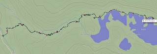
Trail head: Davis Lake
Hike Info:
Trail: Cross-Country
Destination: Goddard Canyon and maybe a little beyond
Actual Destination: Goddard Canyon
Distance: 5.8 miles
Travel Time: 12:30
Moving Time: 4:32
Elevation Rise: 1,098'
Maximum Elevation: 11,175'


Description:
Got up at first light and hit the trail at 7:30. More boulders and more slow moving. Sherri has gained some experience and is moving better. As we move along the lake, we realize just how huge this lake is. Also with the mountain backdrop, how breath-taking this area is. Davis Lake is so clear and we are the only ones here.


This part of my journal is written from memory. I was so tired, that it was hard for me to put pen to paper and have the words come out intelligible. Once free of the boulder field—Andrea and I did continue our system of ferrying Sherri's pack, we rested. We have not gone far, but there has been a lot of effort. Now we are faced with a talus slope of at least 30-40 degrees. And this is a long stretch. But once across this stretch, we should be in good shape. It turns out that once we climb about a hundred feet or so, there is a pathway across the talus slope. And it is pretty level without much give under our feet.


At the end of talus field, we are about three-quarters of the way around the lake, but we will be leaving the lake here. There is a small saddle above us. But before this, we get a splendid view across from where we came. The lake is below us by several hundred feet—from this height you can see almost everything about it. We would not be able to continue on around the lake on our side because of the cliffs coming down to the lake and the falls on the other side. The other side of the lake has even more impressive cliffs. So it is up and over the saddle.


This is easier to do on the map than in reality. We start climbing up the saddle and think we are following a cross country trail—in retrospect, we probably are, but when we come across a ridge, it looks like the path will take us on a pretty shear path, one which I am not sure I want to walk on. So we stop at this pond close to the saddle. It is idyllic. If we had enough food and time, I would say camp here. The pond is really deep—you cannot see the bottom, even though the water clear. We have lunch on a strip of grass and just enjoy the soft breeze blowing. But we need to continue on and we have much of the afternoon left.


I go on and find an easy, bouldering path over the saddle. My memory of this area after 40 years is shot and the things I remember is not very reliable. But after crossing this saddle, we have a nice easy meadow to go down for a quarter mile. But at the end, there is a steep drop, maybe 400'??? down. While it looks manageable, it will be slow going. There is one place where we need to take care and just go down a handhold at a time. Andrea is doing double work by ferrying Sherri's pack. But down we get.


And when we do, it is beside Goddard Creek—this is not to be confused with Goddard Canyon which has the San Joaquin River running down it. Goddard Creek empties Davis Lake and we are coming out below the falls which does the emptying. There is a large sloping meadow here and our only task is to cross the creek to get to the other side, then it should be easy walking for a ways.


Andrea finds some rocks to cross, but Sherri is unsure about this, so I go a little farther up creek to see what I can see. Out of the corner of my eye, I see movement and a flapping of wings next to the falls. When I look over, this bird has a huge wingspan. My guess from the distance I am—150 yards or so—the the wingspan if 5-6'. It has swooped down onto the south side of the creek. The head is white and the body looks black. Sounds like a bald eagle to me. After a minute or so on one side, it flaps up and lands on the north side of the creek. I suspect it has caught a fish. After a minute, it flies away. Unfortunately, I could not get the camera focused on the bird and only got a blurry shot of him flying off.


By this time, Sherri and Andrea have crossed the creek and excitedly join them. They have a small bird chirping close to them—which I get a good picture of. But I can only tell them about the eagle. It is now more down the creek time and the canyon we are in is getting steeper. I see where I think we probably crossed 40 years ago. But this is after we have had another good slope to descend. But on this descent I do find a broken plant and a foot print. So at least someone else has been down this way. We cross a little river-let and it looks like there is almost a path. This leads us on for a ways—right up the side of a cliff. There definitely is a path here which others have taken, but where it goes from here, we are at a loss. After examining the options, we decide, there is a small crack in the rock and Andrea goes up it. She says that we can descend on the other side. So off comes our packs and we push them on up. Sherri has her first chimney under her belt now.


But it is getting late and we are at least a mile, cross-country from the Goddard Canyon trail. We decide that if we do not get down by 8, we will camp. We start our descent again—this time, it is a lot tamer from what we have gone on. But it tame only in comparison. It is still rough. We go up and over a second ridge—this time it is easy. We are able to look into Goddard Canyon and the San Joaquin River. Now the only task is to get down. Andrea leads the way and I work as a guide for Sherri. For the most part, it is more just picking our way down. And down we get as we reach the river at 8. Andrea finds a place to camp—or did I? Anyway, we start pitching the tent and hammock in the dark while Sherri cooks our meal. We will find the trail tomorrow. We turn in pretty much as soon as after we eat, all tired from yesterday.


Note: I found the trail—I went out to relieve myself and found the path.


Saturday, July 28, 2012

July 28, 2012 – Sapphire Lake to Davis Lake

Title: July 28, 2012 – Sapphire Lake to Davis Lake
Trail head: Sapphire Lake
Hike Info:
Trail: JMT and Cross-Country
Destination: Goddard Canyon
Actual Destination: Davis Lake
Distance: 4.4 miles
Travel Time: 10:48
Moving Time: 3:35
Elevation Rise: 1,044'
Maximum Elevation: 11,700'
Map of area
Profile of hike


Description:
We get up at 6:30 or so. The wind is blowing but not as strong. We hit the trail at 7:40 and start our 400' climb to Wanda Lake. We cover the 1 ¾ miles in an hour and a quarter—it is not a bad climb, but we are over 11,000'. It is a nice temperature and we make good progress.


We stop when the trail crosses the creek below Wanda Lake and have a break. It is so wonderful looking back down the canyon. Even with it with a series of unnamed lakes. The sloping ground and the cut off of the land below our view.


But it is not time for us to start our cross-country adventure. We will be going up to a small 11,700' saddle and then drop down into Davis Lakes. 40 years since I have been here. We make it up to the saddle pretty good. Sherri's asthma does not kick in. But now we start going down. It is a boulder field all the way down to Davis Lakes and Sherri does not like it. The mountains are a good backdrop and anytime we want to breath, they are there to admire—ie, a good excuse for me to stop and breath.


But the boulders are a calling and they are there to hamper our progress. It consumes a lot of energy and time going up and over and around them. Plus, we are going on a pretty steep incline as well. Sherri is a bit spooked by then. I help her before lunch. After lunch, Andrea works with her. She does really good with Sherri. Even when we get to the lake. There are boulders and a cliff which force us to go high. We come back down a ravine, which gets progressively steeper. We eventually get down to the lake, but the shore disappears and there is 8' of rock cliff which we scoot along in the water. I in my boots am able to hop from low rock to low rock. The others are bare feet or Teva's. We are tired, but not sure where we can camp. So we trudge on. Andrea does find a place and we decide to settle down by Davis Lake for the night. It is a beautiful lake. We even have a little bit of energy and spirit to play a short came of catch with the frisbee.


Trail Lesson: Fear is a mind killer—Bene Gessart saying from Dune.


Friday, July 27, 2012

July 27, 2012 – Evolution Meadow to Sapphire Lake

 Title: July 27, 2012 – Evolution Meadow to Sapphire Lake
Trail head: Evolution Meadow
Hike Info:
Trail: John Muir Trail
Destination: Wanda Lake
Actual Destination: Sapphire Lake
Distance: 8.9 miles
Travel Time: 10:00
Moving Time: 4:52
Elevation Rise: 2,307'
Maximum Elevation: 10,992'


Description:
After yesterday morning, I stayed in my bag until Sherri moved—probably 6 or 6:30. But I could not outlast Andrea who rose up at 7:30. We discuss this some—Andrea thinks we should have woke her up sooner, and that is probably true.


We have breakfast and Sherri hits the trail at 9:20. Andrea and I follow shortly. We pass through Evolution Meadow, the least of the three meadows in Evolution Valley. Making good time. But we start climbing up a ridge and get to McClure Meadow.


This meadow is just so pretty. You get the idea of a perfect Valley It is some place which you can spend time just admiring. We do not do it justice. Just before Colby Meadow, we catch up with Sherri and take a break.


This starts our leap frogging of a Japanese man00older with limited English. We would pass him several times. Very courteous. Later it looks like he was hobbling and we offer moleskin, but he says he does not have blisters.


The JMT book sad we might need to wade one creek. But it was pretty low so we crossed o a log. Then the start of our steep 800' climb. Coming up the Valley, we already rose up 900'.


We spot a couple of waterfalls and head over there. I borrow Sherri's Teva's and go under the falls—cold--not shocking cold. But it did get the heart racing. Andrea did the same thing after I was through.


We are hot and slow. But there is enough eye candy, mostly The Hermit, to keep us going. The U-Shape of the Valley gives a peaceful feeling. The altitude is also working against us. We are about 10,000' now. Well that is except the energizer bunny—Andrea--who still has a bounce in her step.


By the time we get to Evolution Lake, it is 4. Sherri is still good for Sapphire Lake. So we start the 2 mile, 200' trek there. Andrea goes ahead to find a camp site. In contrast with the warmth of the day, the falling evening shadows send a chill through us. Then with the breeze, it is getting downright cold.


The site Andrea has found is by the Lake, smooth enough to pitch our tent. So Andrea will sleep with us tonight. Good thing she bought us a 3 person tent. While dinner is being made, Andrea and I go fly a kite—at 11,000' for our capture California points. We eat, clean up and watch the sun set—or more accurately, we see the light leave the surrounding mountains.


Trail Lesson: Waterfalls are a great source of refreshment—both visual and when you personally plunge in.


Thursday, July 26, 2012

July 26, 2012 – San Joaquin River to Evolution Meadows

 Title: July 26, 2012 – San Joaquin River to Evolution Meadows
Hike Info:
Trail: John Muir Trail
Destination: Evolution Meadows
Distance: 8.3 miles
Travel Time: 8:11
Moving Time: 4:41
Elevation Rise: 1,824'
Maximum Elevation: 9,257'


Description:


Got up around first light. But Andrea and Sherri are still sleeping. I just wander and sit and write. Around 8:30 there is stirrings and they get up and pack and we have our usual breakfast of oatmeal.


We hit the trail at 10:10. The trail is an easy to moderate grade up this morning. But we are in the sun. Seat comes easily to me as we go on—pretty good clip so far. We reach Piute Creek around 11:15 and have a gorp stop.


We get going again around noon and it is a long hot, but moderate uphill. But the sights are improving. The gorge which the San Joaquin River runs through is narrowing and the water rushes down. We stop again about 1:30 at an unknown place for lunch. There is shade and access to water. We have lunch there and continue on. A little later, we cross the San Joaquin River, on a bridge. Not there is shade for us, as we walk along the western side of the river. After a mile we come to the Goddard Canyon Junction.. We cross the river—on a bridge, once again. It is time for a decision and a break. Do we go up to Evolution Valley? Or stay here and camp? We decide to go up.


We meet a group of females—eight in all. They are doing the JMT—there are some other women in the group as well, doing a section of the trail. They are called WILD. The trail up is step—one step, one breath. Good part is there is lots of eye candy on the way up. First it is up and down the canyon views. Then there is a creek coming off the side of the canyon walls opposite us. As we climb, the view change and grow deeper. It takes my mind off of the heat and weight.


We stop at some falls, a couple of hundred feet below Evolution Valley. Nice to watch. I go up next to the creek to watch the water flow—good rock and the ascent Is fast. Before we know it, we are walking level. We meet a winemaker from Gallo who lives in Fresno—good talking with him.


We need to cross Evolution Creek. It is time to take off our shoes and wade. Not a bad crossing. Once on the other side, we hike 10 minutes and find a good spot around 6pm. Dinner is a mashed potato, cheese, and jerky combination. Got everything clean.. Andrea gets a fire going to burn some moldy pepperoni sticks and then it is off to bed.


Trail Lesson: Early stars makes for good walking.