Title: November 17, 2017 - A Different Wawona Loop
Hike Info : Description : Background : Extra Photo's : Animals : Flowers and Plants

Trail head: Wawona Parking Lot
Hike Info:
Type: Hiking
Trail: Unnamed, Wawona Meadow Loop, Flume
Destination: Wawona Arboretum
Actual Destination: Wawona Fish Hatchery, Wawona Meadow Loop
Distance: 6.06 miles
Start Time: 11:28
End Time: 3:50
Travel Time: 4:21 (1.39 mph)
Moving Time: 4:05 (1.48 mph)
Elevation Rise: 764'
Maximum Elevation: 4,279'
GPS TracksDescription:
 It was raining last night both in Fresno and Wawona, so it was a last minute decision to go or not to go. It obviously was a go, so we leave Fresno just about 10am. We get to Oakhurst and stopped at Judy's Donuts for pastry and coffee. By the time we get to Wawona and get already it is around 11:30. But that's OK. This is not a long and strenuous hike. It is more of an exploratory venture with some hiking option.
 |
| Wawona Golf Course |
The goal is to find the Wawona Arboretum. I had read about it in Shirley Sargent’s Wawona Yesterday's book. Then there is a Facebook Yosemite History group which was discussing the arboretum, one person gave GPS coordinates for some key points, along with navigation to it.
 |
| Old Smokehouse |

The first task is to see if I can find the starting, particularly a bridge across a little creek separating the road from the golf course. Sure enough, there is a road, crossing the creek and the road skirts the golf course. This may be the tee for either hole 1 or 2-unsure. But then we came to the old Wawona Smokehouse, now the golf course keeper’s storage building. We are at the far north end of the golf course now. We go around the south side of the building and there pop’s up a little used road.
 |
| Our Path |
 |
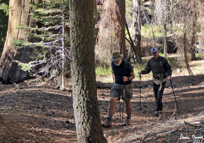
| Gary on Trail |
 |
| Sherri going up Big Creek |
There is a short rise on the road. Because it rained last night, everything is glistening with raindrops clinging to leaves and needles. Refreshing. While there is practically nobody in Wawona today, at least by usual standards, I doubt that anybody would be here even on busy days. Less than a quarter mile later we come to a place where this little road dips down to the confluence of Big Creek and the South Fork of the Merced. But at this point, there is a little track which juts off straight to Big Creek.

Not expecting anything, but a trip to Big Creek, we follow it. While it does go above Big Creek, it turns to follow it. Since the creek looks pretty imposing to cross, we just follow this track, obviously used some, but definitely not maintained.
 |
| Big Creek |
With the creek full, probably from last night’s runoff, we take pleasure from watching water flow over and around boulders. Most broadleaf trees have already shed their leaves, leaving the pines to provide greens to contrast with the browns of the oaks and maples. All of this gets intensified by the wetness on the trees.
 |
| Big Creek |
The track continues to follow the creek. But as we continue up, the track changes to more rocks, not climbing them, but walking up them. The ravine narrows and grows steeper. Then I either take a wrong turn or the track stops. Either way, I come to a small ledge and the track is no more. We have gone about a third of a mile along the track.
 |
| What is a piece of cement doing here? |
We backtrack, enjoying the scene in reverse until we get to junction. We follow it down to the confluence of Big Creek and the South Fork of the Merced. We pass a curved piece of cement and wonder what it was used for?
 |
| An old trail? |
In 20 yards, we come to the roads end. Looking around, there is appealing way across Big Creek. We will leave the old arboretum for another day. Instead, there is a hunt for where the Wawona Fish Hatchery was. Maps show it more up from the water. While it seems more likely some areas which looks like they were chipped out from the riverside rocks. Was our cement piece part of it? Need to figure that out.
 |
| Confluence |
 |
| Remains of old hatchery? |
 |
| Clark's Sequoia's |
 |
| Old Fruit Tree |
We go back to the golf course, noting that we are adding in streams of light to the glistening wetness. At the golf course, we spot a sign that 150 yards away was Galen Clarks original home. So what do we do? Take a look at the direction to explore. He had planted four Sequoias which we find quickly enough. It is hard to hide 160 year old trees. There is nothing but a field and a few of his fruit trees, way past their fruit bearing time.
 |
| Galen Clark's Homestead site |
 |
| Creek Crossing |
Now do we go back? No way. We figure that if we loop around the back side of the course we should be able to reach the Chowchilla Mt Road pretty easily. Let me just put it this way, it was not hard. But a bit more work with small trees and downed logs than anticipated. A few times we walked on the edge of the green-grass was pretty high. We got to a place where there was a service road and we cut over to it-not a place which they would have wanted to hit the ball anyway. That got us to the Chowchilla Mt Road pretty quickly. There we ate lunch and discussed options.
We decided to enjoy a walk around the traditional meadow loop. It was getting late and we thought if we wanted something more at the end of the loops, we could get the trail which climbs up to the trail from Mariposa Grove. We set a pretty good pace, at least for us. Of course, it is mostly a dirt road with a few small ups and downs. We quickly get to the end of the meadow and decide to continue on around. Two uneventful creek crossing later we hear Highway 41 overhead. We think that is all to our adventure. But not quite.
 |
| The Ditch |
The trail approaches the highway, but then veers off and parallels the road. But I spot something which looks like a trail on the other side of the road. We have not been down this before, so after talking it over with Sherri, we decide to see where this adventure takes us. It turns out it is a ditch or a flume-looks too small to run anything down it, so we will go with a ditch. Now the question is, what did they use this ditch for? Actually a second question should be, how far can we walk it before it becomes impassable?
 |
| Sherri Walking Ditch |
Actually, for the most part, it is pretty walkable, at least the first part. It is flat almost all the way-needs to be for the water to run down it. It is not meant to be a path, but the top of the ditch is level and walkable. But because it was not meant to be a path, there are downed trees across it. Also lots of small trees between 5 to 15 years old have grown up causing a bit of a sense of plowing through brush. Some of these force us off of the ditch top and work around it. But not too much of a nuisance. We see our usual path below us, along with an old road bed.
When we get to a fire road, we turn down that and hit the Wawona Hotel and work our way down to the closed for the season visitor center. So it is onward to the lower parking lot and our car. Pretty good day.
We stop in Oakhurst at El Cid’s for dinner where we each pick up a burrito. Then onto Reimer’s for ice cream. Finally home around 6:30. Another good day.
Background
Wawona Smokehouse. A second store, begun in March 1920 on the approximate location of the first one, contained a butcher shop and smokehouse, it burned about 1943-44. From Linda Greene’s Sept 1987 historic resource study, v2
Ah You was chef for half a century and was famed for his delicious pies. Most of the Chinese help lived up-stairs in a building near the smokehouse. At first when they were moved to a larger, newer building, with a bathtub, near the laundry, Ah You, Ah Louie, Ah Wee and the others complained of its large windows and spaciousness. From Shirley Sargent’s Wawona Yesterday’s
Wawona Fish Hatchery. From CaliSphere: the hatchery opened in 1895 to provide fish for the lakes and streams in Yosemite. Started by the Yosemite Stage Lines, then the California Fish&Game (probably its forerunner). The idea was to generate 500,000 eggs annually. The manager was an E.L. Cross. The fish were ok until about July 1st, then the water got too warm and it generated algae. Also there was possible contamination from its water source: Big Creek. Closed in 1928.
According to the NPS restoration study. on the arboretum, the US Army also took part in fish stocking from 1905-1908.
From the Report of Historical Landmarks Committee of the Native Daughters Golden West, it says that:
The Wawona Fish Hatchery is a delightful walk of three-quarters of a mile from Wawona Hotel, and visitors will find the operation of hatching the eggs very interesting. Five hundred thousand eggs are hatched yearly and the fry planted in the various lakes and streams in the vicinity of Wawona.
From the California Fish and Game : Guy Tabler was foreman in charge. In 1920, the experimental fish hatchery at Happy Isles was dismantled and all the equipment was moved to Wawona. It also says that for many years the work of M.L.Cross was above criticism
Three hundred thousand rainbow eggs, and 100,000 steelhead trout eggs from Brookdale Hatchery, have been shipped to Wawona from the Mount Shasta Hatchery and the resulting fry will be distributed in Merced River and other streams of that section during the coming summer. Previous to opening the Wawona Hatchery for operations on April 23. certain necessary repairs were made to the flume and water distributing system at the hatchery. All the repairs could not lie finished this spring, consequently, we will have to complete the work after the fry have been distributed during the summer.
The first report of planting fish in Yosemite was in 1878 by a man named Kibbie. He was a homesteader living at Lake Eleanor and he planted some rainbow trout in Eleanor, Laurel and Vernon Lakes. The first official plant of rainbow trout made in Yosemite by Fish and ,Game Commission was in 1892. The Washburn Brothers had erected a fish hatchery at Wawona in 1895. This was operated by the State Fish Commission and millions of fry have been distributed in the lakes and streams since that date. Ed Gordon a packer working for Washburn Brothers at Wawona, participated in making many plants of fry in the Park. The U. S. Troops also assisted during the time they were on duty in the Park.
There is a YouTube video from Abandoned Yosemite on the fish hatchery. Shows about as much as we saw, or maybe less.
Wawona Arboretum. Possible NPS restoration study. Full of information, 20 page document. Arboretum constructed in 1904 by the 9th Army Cavalry (i.e., Buffalo soldiers) and 24th Infantry About 1,400’ west of the confluence of Big Creek and the south fork of the Merced., on the slope above the river. It was acting park superintendent Major John Bigelow, Jr, who commanded Troops K and L and the 9th Cavalry who created the first National Parks arboretum. 75 acres. It was the first marked nature trail in the National park system.
From the Mariposa Gazette, Oct 29, 1904:
TROOPS LEAVE WAWONA. Soldier Guardians of the National Park Forsake Posts for Winter.
Captain V. H. McCormick, acting Superintendent of the Yosemite National Park and commanding officer of the First Squadron (Troop* C and D), Ninth Cavalry, United States army left the park Saturday en route to the Presidio of Monterey. …. A great many innovations have been made, the most prominent among which are the arboretum, suggested by Major Bigelow; a new bridge spanning the Merced and the renewal of the Chilnualna Falls trail. The arboretum will be one of the most interesting features in the Yosemite National Park and the resort of botanists and all those interested in forestry. Almost every specie of plant life indigenous to tin Sierras has been collected and botanically classified. The space covered by the arboretum is about ten acres. The spot was selected on account of the beauty of the surroundings and the variety of trees already there. __ is at the junction of the south fork of the Merced and Big Creek, just below the post, and is adjacent to the State Fish Hatchery and the Wawona mineral springs, thus making the walk from the hotel to the post a series of attractions. That the sightseer may not grow too weary, every shady nook has a rustic bench, many of fantastic designs artistically arranged by the quartermaster, Lieutenant Edmund A. Buchannan. The place is a veritable park, as all the underbrush has been cleared and a great deal ol landscape gardening done. Connecting the post to the arboretum is the new bridge, which enables the pedestrian to visit the post. ….
Extra Photo's
 |
| Smokehouse |

 |
| Big Creek |
 |
| Possible site of fish hatchery |
 |
| South Fork of Merced |
 |
| Gary browsing |
 |
| Fallen Branch with sunlight |
 |
| South Fork of Merced |
 |
| Golf Course |
 |
| Small Waterfall on Meadow Loop |
 |
| Big Creek |
 |
| Bear Scat |
Flowers and Plants
 |
| Sugar PIne Cone |
 |
| Mushroom at Fish hatchery |
 |
| Fungi |