|
| Car Route |
Type: Hiking
Trail head:
Desolation CanyonTrail: Desolation Canyon
Destination: End of Trail
Actual Destination: 8’ dry waterfall about a mile in
Distance: 2.01 miles
Start Time: 9:36
End Time: 11:44
Travel Time: 2:08 (0.94 mph)
Moving Time: 1:01 (1.98 mph)
Elevation Rise: 285'
Descent: 315‘
Maximum Elevation: 289'
Hike Info:
Type: Hiking
Trail head:
Dante PeakTrail: Dante Peak/ Mount Perry Peak
Destination: Dante Peak
Actual Destination: an overlook
Distance: 0.49 miles
Start Time: 3:02
End Time: 3:45
Travel Time: 0:43 (0.69 mph)
Moving Time: 0:25 (1.18 mph)
Elevation Rise: 240'
Descent: 138‘
Maximum Elevation: 5,593'
GPS Tracks
Car Mileage: 90 miles
Description:
It
was a good night sleep with the skies lightning up for us around
6:30. Both of us got up shortly after that. But we were not moving
with purpose. It is around 8 when we start eating our french toast
and bacon. We left camp after 9 for Desolation
Canyon.
 |
Gary at the start of Desolation Canyon
|
We
first see the full parking lot for Golden Canyon/Gower
Gulch. Glad we have decided to go up Desolation Canyon-only a
couple of cars parked there. Once we get to the parking lot, we
remember we have done this trail before. But that is OK-as Sherri
said, she is delighted just to do what we have done before.
The
trail goes right up the canyon. The sides of it shows an assortment
of color, not as vibrant as some places, still nothing drab about
this walk. The UP portion of the initial statement is right. The
trail goes against the water flow which created the canyon. Not an
extreme ascent, but enough to let you know we are going uphill. The
first half a mile is in the sun. For being 70 degrees, it is
obnoxious. Sherri stops to put on sunscreen. But when we come to a
major divide, we enter into shadows. My spirit is revived and my step
becomes more lively. More sand is deposited from the tops of the
canyon. It is fascinating just looking at these cones of sand.
 |
Canyon path
|
And
then we round a bend and see a couple seated. And then we realize why
they are seated. There is an 8’ dry water fall. Plenty of footholds
to go up. Not sure if I could get down without breaking something.
And then, according to the book*, there is another waterfall to
climb. Neither Sherri or I are enthusiastic about the prospects of
this. So we sit on the other side of the canyon and talk with the
other couple. A few minutes later another couple comes by. The lady
scampers right up the waterfall. The man waits a minutes and follows
her. They do not come back.
A
few minutes later another couple, we find out from Wisconsin. They
look at the wall and the guy goes up it, only to return about five
minutes later. He sort of figures out his way down, jumping the last
several feet. They leave, so the other couple is left with us.
 |
Sherri in the Canyon
|
We
talk about several things-where we are from-they are from Eugene,
Oregon. Their next place to go is to Joshua Tree and then to San
Francisco. As they are about to leave I notice he has a backpacking
backpack with him They have done the JMT in sections. We exchange
notes about our experience. Their trail names are Fungi and Fragile
Forder
(in real life it is Jeff and Janice). Glad to have meet them. We
realize that Janice was the one who yesterday warned us about the
party campsite.
After
they leave, we also go on down. There is a side canyon we go up-only
a hundred or two yards until we come to a truly impassable dry
waterfall, about 25-30’ up. We turn back and make good time back to
the parking lot. Shortly afterwards the couple who went up the wall
returned and said the view was great up there.
 |
Gary and Sherri at Artist Pallette
|
Sherri
had been reading about a trail in the book* called Artist
Dips. It is a route on Artist Drive between two dips in the road.
We go drive the road, see the dips. Now to see if we want to actually
walk it. There is two dry falls on the route. One 5’, the other 7’.
At least we would not need to climb down the walls.
See
our November 18th
hike.
 |
Afternoon meditation
|
We
feel it is getting a bit warm, so we head up to Zabriskie
Point, which is a couple thousand feet above the Valley floor.
Before
we go to the point, we find a spot in the shade and have lunch.
Sherri goes into her meditation mode-I thought she might have fallen
asleep. So we rest for a lot longer than our five minute allocation.
Afterwards, we go up to the Point, a short, but steep paved trail. We
take a look around. I take note of Manly
Beacon-I am reading Manly’s autobiography. We talked about
doing the Badlands Loop from here, but decide not today.  |
Badwater from Dantes View
|
But
there is still time for an adventure. Up the road is the 20
Mule Team loop-driving. We take that and are duly impressed The
route is only a mile or two on a dirt road. I think the idea is give
the tourist an example of the type of terrain these teams had to
drive. It is an enchanting area.
We
continue our drive to Dante’s
Peak area-you cannot drive to the peak. The area is 5,300+’
above sea level, right above Badwater
which is 200+’ below sea level. Quite a contrast. The
view is awesome. Clouds stretch out as far as we can see. But the
view down and across the Valley can leave ne with a case of vertigo,
if you are not careful. Looking beyond the ranges around the Valley,
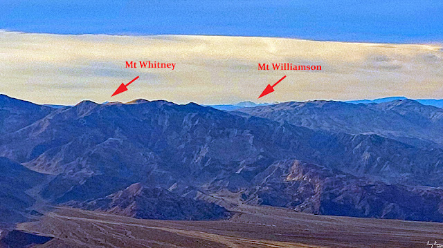
it looks like I can see Mt
Whitney. A Wow! moment as you can see the lowest and highest
points in the continental United States from here. (In
looking at PeakFinder, I am
wondering if what we are seeing is Mt
Williamson. Still a pretty close relative to Mt Whitney. I
suspect a bit up we would see Whitney.)
 |
At Dantes View
|
The
book* says that it is an easy one mile walk to the peak. There is
plenty of light, so we decide to do it. While I do agree that the
rise is not bad, the trail itself is cut above a drop off. When we
come to a split in the path, we go to a point which overlooks the
Valley. The rest of the trail looks a bit precarious. Even the trail
to this point is not without its nervous points. We decide this is
good enough for us, so we turn back.
A
couple is trying to determine if they want to go to the point. The
woman is a bit nervous about it. I give some “sage wisdom” about
how to tackle it. When we look back, they are standing where we were
on the point. By the time we get back to the parking lot, they are
also there. We high five their accomplishment. They ask what else,
but they are going on to Las Vegas tonight. So
there is not much else. We share the wonders of the parks in the
west. Then it is time to head back to camp.
While
up at the Dante Peak area, we noted the sky growing dark, not only
because of the sunset, but because clouds were gathering. It looked
like up north might be getting some rain. So we stop in at the
Visitor Center. They say no chance of rain and only clouds. Sounds
good. Not going to put a fly on the tent then. We also stop at the
market and get some ice and syrup. Then back to camp.
Sherri
fixes dinner-soup and a hot cheese sandwich. Tastes good and is
satisfying. At 7pm, we phone in to Zoom for our House Church, We only
stay as long to hear the prayer requests and then leave before Bible
Study. It is dark here. Shortly afterwards, we get prepared for bed.
Lights are off by 9pm.
Background
William
Lewis Manly-Death
Valley in '49, This is a journal well worth the readng, not
for the literary value, but to see the dangers of the time to get to
the California gold fields.
Best
Easy Day Hikes Death Valley National Park.
We
went on two hikes listed in this book on this day:
Desolation
Canyon. The book has as a moderate hike. This is if you go up and
over the two dry waterfalls. We just went to the base of the first
waterfall. For this it is an easy hike. The description of the hike
seems pretty good.
Dante’s
View and Point. The book has
this
as an
easy(???)
one mile hike to Dante's View and Peak. Elevation rise of 229'.
While the trail itself is easy, it is a use trail on the side of a
ridge. So the "easy" part is a bit misleading,
particularly for those with height concerns.
 |
Entrance to Desolation Canyon
|
 |
| Erosion |
 |
Color in Desolation Canyon
|
 |
Canyon as a wash
|
 |
Gary in Desolation Canyon
|
 |
Scree slide from the steep canyon walls
|
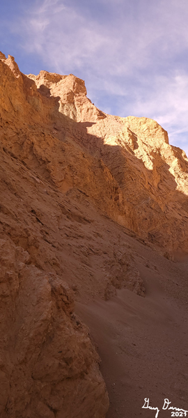 |
Golden color canyon walls
|
 |
20' dry waterfalls
|
 |
Sherri going out of the canyon
|
 |
Artist Pallette
|
 |
Badlands and Manly Beacon from Zabriskie Point
|
 |
Badwater from Dantes View
|
 |
Mt Williamson from Danes View
|
 |
| Badwater from Dantes View |
 |
Trail to Dantes Peak
|
 |
Looking north from Dantes View
|
 |
Looking across into Nevada and the Great Basin
|
 |
Artist Pallette
|