Showing posts with label Ft Monroe. Show all posts

Friday, February 21, 2020

February 21, 2020 - Old Wawona Road


Title: February 21, 2020 - Old Wawona Road
Hike Info : Description : Extra Photo's
Trail head: Bridalveil Falls parking Area-or close by
Hike Info:
Type: Hiking
Trail: Old Wawona Road
Destination: Ft Monroe
Actual Destination: Inspiration Point
Distance:  5.20 miles

Start Time: 11:29
End Time:    4:25
Travel Time:  4:55 (1.06 mph)
Moving Time: 3:33  (1.47 mph)
Elevation Rise:  1,537'
Descent: 1,371‘
Maximum Elevation: 5,387'
Description:
Our Friendly Raven
We left our house around 9 and are heading to Yosemite. We think we will be going up the Old Wawona Road towards Inspiration Point and then on to Ft Monroe. We stopped at Starbucks in Oakhurst before entering the Park. After a pit stop at Chinquapin, we head on down to the Bridalveil Falls parking lot. Actually, we park at a turn out across from the start of the trail.
Start of Old Wawona Road
We spend a few minutes getting ourselves ready and then we cross the road. With one last look back, we spot a large raven on our car. Sherri goes into her cow chaser mode and shoos away the raven, but for how long?


First Creek


Now we really start off. The road is disintegrating-of course it is many years old with no maintenance. But there is still lots of pavement remaining, just crumbling. Erosion has taken its toll, which on the whole is not a bad thing. The Park is letting it return to its state before pavement was there. Also there are more trees down than when we were here last, a couple of years ago. When we come to where the creeks cross the road, the footing is a bit more tentative with the potential of rocks rolling on us.

El Capitan

Artist Creek

But we do enjoy ourselves going up this road. Not far up the road, we come to the first highlight of our trip: Artist Point. Just the name gives this one away. This is where the early artists: painters and photographers did their work. And there is a good reason for this. It is a perfect view on a perfect day. And we stay to savoir it by having lunch there. We rest on a rock and just soak in the day and the sight. I should also say that Steven has climbed a rock and enjoyed his lunch 15’ above us. Sherri gets an action shot for her photography class-a bit of air under Steven’s feet.


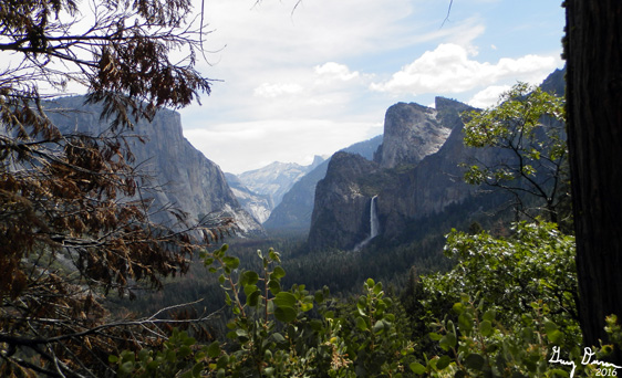
Yosemite Valley From Artist Point
Trail in need of Maintenance
We continue on. While having lunch in us feels good, we are still going up. So I continue my huffing and puffing. After about ¾ of a mile later, we get to the junction of the Pohono Trail. Most people go straight up the trail to get to Inspiration Point. We continue on the Old Wawona Road. While still going up, it is not as steep as the Pohono Trail. Besides there are a few views across the Merced River. This is a good way to go.
 The one problem is because this is rarely used, it is not maintained. So there are a bunch of downed trees. But nothing which stops us. Besides we get a few pictures which we just might share. Eventually we get back around to Inspiration Point.
It is another mile or so up to Ft Monroe. But we think that it may be getting a bit late. Besides that was a pretty good up for me at my stage of conditioning. So we just sit and enjoy the view. A group from YWAM (Youth With A Mission) comes up and we talk with them for a while. They head off and we continue to enjoy the area.

Looking across the Merced River
Steven on the Pohono Trail

Then it is time to head off. We go to where I think the trail goes down. But what do I know? We went down 40’ and hit a dead end. So back up and we take Steven’s choice, which leads us to the Pohono Trail. And the trail goes down steeply. Glad we came the way we did.
One of my favorite places on the trail is a little use trail about half way down to our junction. It leads off to a point which I have called Gary’s Point since the first time I went there. I immodestly think it has the best view from the west side of the valley. Others may disagree with that assessment. Steven and Sherri come along. I am not sure they agree with my thoughts on this, but they duly take an appropriate amount of pictures.


And then it is down the trail a bit more until we reach the Old Wawona Road. It is much easier, and faster, going down this road than going up it. Still in very many ways I prefer the other direction. Being faster is not better. Having to stop occasionally gives one the time to take in what you only glimpse when you speed past things. (I do use the term speed, very loosely.) We pass by Artist Point, stopping to gaze at the later afternoon shadows playing on Cathedral Rocks behind Bridalveil. And then it is down again.
By the time we reach the car, it is closing in on 4:30. Steven takes pity on his father and drives down to Oakhurst. There we reward ourselves at Southgate Brewery. And then home we go. A good day. Maybe a bit disappointing we did not make Ft Monroe. On the other hand, a destination is not everything.


Extra Photo's

Yosemite Valley
Gary on the move
Artist Creek

El Capitan in Black and White

Clouds Rest

Yosemite valley

Bridalveil Falls and Cathedral Rocks
Sherri, Bridalveil Falls, Yosemite Valley from Artist Point

Patch of Ice

El Capitan and beyond

Tower at Turtleback Dome
Yosemite Valley from Inspiration Point


Yosemite Valley from Inspiration Point
Clouds Rest

Bridalveil Falls

Yosemite Valley from Gary's Point

Yosemite Valley from Gary's Point

Thursday, May 19, 2016

May 19, 2016 - Ft Monroe


Title: May 19, 2016 - Ft Monroe
Hike Info : DescriptionBackground : Extra Photo'sFlowers and Plants

Trail head: Bridalveil Falls Road
Hike Info:
Type:  Hiking
Trail: Old Wawona Road
Destination: Ft Monroe, maybe beyond
Actual Destination: Ft Monroe
Distance: 6.91 miles
Start Time:  10:19
End Time:     2:09
Travel Time: 3:49 (1.81 mph)
Moving Time: 3:16 (2.12 mph)
Elevation Rise: 1,760'
Maximum Elevation: 5,581'


Description:
Sherri and Steven want to bike ride around Yosemite Valley, so this gives me about three hours to go hiking and wandering. The biggest challenge is where? What am I in shape for? What is of interest to me? What is the meaning of life? Oops, not the last. So after doing a fair amount of pondering, I decide to walk the Old Wawona Road to Ft Monroe. With a little bit of effort, I might be able to go beyond where Ft Monroe is and explore a bit. But this might be optimistic.

We leave Fresno around 7:45. I need to stop at Kaiser to pick up a prescription. While I am doing that, Sherri and Steven pick up gas for the car at Costco. Then it is off to Yosemite and adventure. We get to Bridalveil after a brief stop at Chinquapin for their bathrooms. Instead of parking in the Bridalveil Falls Parking Lot, we have to park along the road a couple hundred yards away. By the time I start walking, it is 10:15.
Beginning of Old Road

Downed Trees
I walk the pavement past the parking lot and up another quarter mile to the start of the old road.This road is partially paved, but is a wonderful hike. It starts to climb and as the politicians might say, Can I feel the burn? While the rise is not steep, it is steady. There are many downed trees-more than what I had seen last year. A wet Winter, maybe, or just an aging, un-maintained trail finally start deteriorated to this point? But I enjoy going places where others do not go. So I continue going up the trail, or should I say road.

Ribbon Falls
There are two running creeks in place of of the dry ravines I have seen before-except when I had a hike in a pouring rain. The first creek is Meadow Brook, which above me Silver Strand Falls is created from. No wonder Silver Strand is only a seasonal falls. After that is Artist Creek. I know at that point, I am getting close to my first point: Artist Point. This is one of the finest view of the Valley, except for one.

View from Artist Point


After properly gawking here and trying to find the benchmark-which I don't see, I continue my walking. On the way up, I see a couple looking for Artist Point and I point the way and continue on with mine. Instead of going directly up to New Inspiration Point, I continue on the more gentler route with the road. It goes up and gives a good, but not the greatest, view of the Cascade Falls area. After that, and a few more trees to go over and around before I hit Inspiration Point.

Cascade Falls From Ft Monroe
But my goal is not Inspiration Point, but at least making it to Ft Monroe, and hopefully beyond. At Inspiration Point, I see a few people, but do not stop or even say hello as they are a ways away and I want to get on.  More uphill, but not bad. The times I have walked up here, it has been dry. Today, various places of the old road is a bit mushy. Previously, I had seen this old pipe laying on the side of the road, somewhat buried and could not figure out why. Today I see a bit more as water is draining from a small pool behind it. I suspect that at times, this could have been a water supply for someone.
Old Pipe


Cascade Falls
I finally get to Ft Monroe, which if you have read my other blog entries you know that it never was a fort, but a stagecoach stop named after George Monroe, a black stagecoach driver. I realize that I am little bit beyond my turn around time, but I need to have lunch. I spot a place about a hundred yards off the road which looks like it has a good view, and that is where I eat. This is a good place as you can see down the Merced River and across to the Cascade Creek area. Nice and peaceful view.

Yosemite Valley from Inspiration Point


But now it is time to return. The first bit is down the road I just came up. But then it is downhill, sol I make good time. I stop at Inspiration Point to get the "standard" photo from there. The view is good and Yosemite looks fabulous. Also Bridalveil is good looking. One can stay up here forever with a mouth open, gaping at this. But I need to go on.

Bridalveil Falls from Inspiration Point


Why you might ask? First, because Sherri and Steven will be waiting for me at the parking lot. But also because there is another view which I like a lot better. I call it "Gary's Point". But I know I am  not the first to find it, only one of many who has come across it because there is a path to it, away from the Pohono Trail-which ends at Tunnel View. I found this view a few years ago when I was walking this trail with a few other people and came across the path. I took it to see where it went and saw the best view of the Valley. As a bonus, the path points straight to Silver Strand Falls

Yosemite Valley from "Gary's Point"
Silver Strand and path to Gary's Point


Trees across road
But now, I get walking again and meet a couple who I judge to be a bit older than-hard to believe isn't it? They are backpacking and going to go up to Ostrander Lake. They start at Tunnel View and are doing the climb up-this is a 3,000' ascent. We exchange notes about things and tell them there is a good camp spot at Bridalveil Creek. They are relieved by that. Now I head the two miles back down the Old Wawona Road, stopping to gawk once again at Artist Point. I cross the many fallen logs I encountered when I came up it.

I get to the car without incident around 2:10. Sherri and Steven have been waiting for me for about half an hour. They had made two loops around the Valley floor and enjoyed their time. So off we go to Oakhurst and the Southgate Brewery before heading home.


Background
See my write up on Artist Point, Ft Monroe and the Old Wawona Road for more information on these items.

Extra Photo's

Yosemite Valley


Ribbon Falls and El Capitan

Cascade Falls and the Devils Dance Floor


Afternoon shot of the Valley from Artist Point

Flowers and Plants


Puffball Fungi

Phlox