Showing posts with label Pine Ridge. Show all posts

Wednesday, July 1, 2026

July 1, 2026 - Delilah


Title: July 1, 2026 - Delilah
Hike Info : Description : Extra Photo's 
Hike Info:
Type:Lookout
Description:

It was a warmer night last night. Even the floor was not cold when I got up at 0510. I checked for any lightning and found none. In the process, I realized that how I was interpreting EGP was incorrect. I need to investigate more. But I think that even when I specify a map set, it is not using it to what I specify rather what is on the screen. That explains that when I pull data, I get outside of the parameters that I specified

I have a leisurely granola breakfast and then go out for a walk. I go further than I have on my last several walks and had more of an incline. Does this mean I am getting into better shape? Probably, but neither does it mean I will be going out tomorrow with a full backpack going up a good slope for 10 miles. It is an improvement and I am glad for improvements.

I got back into the cab about 0830. While the walk was good, the trip up the stairs left me pretty tired for 15 minutes. By 0900 I was doing a scan, then took the weather and went into service at 0930, along with Park Ridge Lookout.

Not much went on in the morning. I continued to do the scans and stuff. Buck Rock did not hear who the duty officer was during the 1000 staffing report and asked Park Ridge who also did not hear. I had recorded the staffing and played it back, so I could hear who the duty was-BC31. When Buck Rock asked me, I could tell her.

On the day when I am leaving, I have my dinner at lunch time. Today it is a repeat of Monday: enchilada and Stagg chili beans. By the time I ate and washed up everything, it was a little past 1300. So I took the weather. The relative humidity is still high compared to how we usually are around here. Then another scan and time for a 15 minute rest time.


Goat Saddle area
A few more scans. I had just finished one of these scans at 1400 when I heard CalFire, FKU, say that there was a wildland fire called the Guide Fire. I could not decipher the location, but it sounded like it was local. I started scanning, but did not see any smoke. This is not unusual as Pine Ridge blocks about 80 degrees of the area to the south of Delilah. Then Porterville calls it out and the smoke starts to rise up over a branch of Pine Ridge called Dude Ridge. I am able to confirm the smoke. In about seven minutes, that puff was gone, before I could get a good picture.


The area I saw the Guide Fire smoke, mostly dissipated 


The rest of the afternoon is normal stuff. Well sort of. At 1525, while I was doing my scan, I saw something big fly across my binoculars field of vision. There are two hawks gliding around, flying the air currents. Then one of them sees something and makes a beeline into the trees below the tower. I never saw it again. But it was fast. Then the second dives into another set of trees to the west. I lost them then. I guess that is the end of the saw. When I looked up the birds in my John Muir Law’s book, I was wondering if it was an eagle of some type.

At 1600, I responded to Sierra’s lookout check in. There are four of us: Buck Rock, Delilah, Miami and Signal. A little while later Mt Tom went into service. It has been awhile since I heard his voice. I have never met the man, but it is good to have him back.

Sometimes during the afternoon, I heard a report of smoke from Miami Lookout. I have a special interest in Miami. We have hiked up to it several times, but it has never been open. I think starting last year it was being staffed. The lookout was reporting a smoke a half a mile from his lookout. A short time later, he gives a legal location, which puts it at Metcalf Gap. I think that is pretty close to the road we walked up to get to the lookout. If I was him, I would not be very comfortable. Sierra and MMU get right on it and nobody sounds panicked.

As the time of 1800 approaches, I get my stuff together and then clean up the lookout. Of course, I am doing my scans. But the last few scans I may not have been as diligent as earlier in the day. I go out of service with Porterville and Sierra. Then take my stuff down, while locking up. As I am about to climb into the car, I find I still have the lookout keys around my neck. I now had to go back and put them away. Then it is time to drive home. I arrived a few minutes before 2000. That shower felt good.


Extra Photo's


Morning view from the outhouse

The early hummer gets the sugar water

Early morning view of the crest of the Sierra. Split Mtn is part of this view


Friday, May 19, 2023

May 19, 2023-Delilah


Title: May 19, 2023-Delilah

Hike Info:
Type:Lookout

Description:

Slept well last night. I woke up to an early morning light around 0500. The subdued orange and pinks of the early morning is always pleasant. The other good thing is, I do not need to get up to enjoy. I just can lay in bed and look out of my glass house. Just before the sun comes up, the area behind Split Mountain gathers light with intensity.

Around 0530 I start gathering information for the day’s lightning report. I know there was some activity because of the clouds I was seeing and the alerts I got. But it turned out there was only a single cloud-to-cloud which nobody cares about. So I do not need to send a report.

I mosey around the rest of the morning. Mich had sent out an email about Delilah which others responded to. Since I am the only one on scene, I take this time to respond. Also I talked with Greg about the water situation. Breakfast is granola and lemon bread, which Wendy gave to me yesterday.


Patterson Falls

Rancheria Falls


I took the weather for the morning. Nothing alarming. Wendy alerts me through a text that I will be doing a relay for Patrol 33. Not five minutes later, P33 summons me and I do it. Yeah! One of those radio things I feel I can easily screw up. I hear Engine 32 go into service to Delilah LO. Company today! And all of this is before I go in-service


At 0933 I go into service with both Porterville and Sierra. Then I start washing windows between doing scans. P33 lets me know that her crew will be raising dust along Davis Road. And I see her convey of trucks heading down, marking areas for drivers to be cautious of. At 1000 Porterville gives the weather forecast. P33 and her gang gets close to Sampson Flat, taking care of some logs and trees. Then at 1100, is the Sierra Lookout check in. Another lonely day-I would not trade it lightly.


Hillside shift above Davis Flat
This gives me a chance to review my area of the world. Usually when I am up here, there is so much which is dry. As I look across the Kings, I am seeing several waterfalls. There is Patterson Falls, at least a significant drop from Patterson Creek. Also Rancheria Falls. Then I am not sure if it is a fall or just a long descent, there is water coming down the ridge into Dinkey Creek. Several places have had mud slides. You can see the scaring in several places, including over on White Deer area, the hills above Davis Flat and on McKenzie Ridge.


Mt Nelson
Lonely not for long as Engine 32 did show up with batteries for our repeater. I got to talk with the head of Engine 32. Most of the time I only hear these disembodied voices over the radio. So it is a pleasure to greet them in person. Not only have they brought batteries, they also brought a replacement fire alarm. We talk for awhile. One of the things he said was that yesterday some Forest Service staff snowmobiled into Buck Rock with batteries. That explains why tone 2 is available.
Engine 32
He then goes down to help move the batteries. Another person comes up, a first year person and we talk for awhile, but he does not seem too interested. Engine 32 moves on and I am left by myself again.

I have my lunch and then settle into the normal routine. That is until 1334. Porterville tones out a fire and it is in my neighborhood. Unfortunately it is behind Pine Ridge, so I cannot help. But I did report I cannot see it. P33 did not catch the address, so I told her what I heard. Also we have a third radio now so we can listen to CalFire when something breaks. That is what I did. That all was worth about 20 minutes of excitement.

And back to the routine. P33 wants a few more items relayed and Division 3 notifies Delilah that our repeater tone should go in service sometime tomorrow. I had my dinner after Sierra 1600 check-in. Then cleaned the floors and generally cleaned up. Not much of a mess on my part.

As 1700 hits everybody is going out of service, except me. I do some more scans and enjoy a bit of quietness. And at 1720, Sierra calls with status of Delilah. I said I would go out of service with dispatch. And now I put the final touches on cleaning up and packing. At 1754, I go out of service with Porterville.

It takes a few minutes to get everything put away and my stuff taken down the stairs. But at 1815, the tire on my car starts to move. I get home a few minutes before 2000. A good, but tiring, couple of days.

 
Flowers and Plants


Sunday, May 29, 2022

May 29, 2022 - Delilah Lookout


Another view of yesterday's rock

Title: May 29, 2022 - Delilah Lookout
Hike Info : DescriptionAnimals : Flowers and Plants
Hike Info:
Type: Lookout

Description:

I woke up around 0515 with the first hints of sun coming over the Middle Fork of the Kings. When I turned over, part of the sleeping bag fell away and I decided that it is a cold, cruel world out there and maybe I would be more comfortable snuggled up in my bag. Looking at the RAWS station, it says it is 47o. This gives me a chance just to lay and watch the sun filter through the clouds. I am not being completely useless, I also see if there was any lightning yesterday-none.

Clouds invading my space
By the time 0630 rolled around I was ready to get up. Well, maybe I am. The neck is a bit stiff. After making a pit stop, I went on a short walk down to the saddle. Delilah’s crowning jewels are in blossom-Common Media’s, elderberry’s, Mariposa Lily’s and its cousins. Even a fawn made an appearance. A splendid walk. I get back up in the tower, huffing and puffing more than I did yesterday with my 35 pound pack. Still got up there by 0740. Now to get ready for my 12 hour day.

Delilah went into service at 0800, the start of a new day. Clouds around the fringes, with one large, non-threatening cloud coming straight towards Delilah from Pine Ridge. I have my breakfast, brush my teeth and put up the flag. I am doing my 15 minute scans as well-of course the eyes are constantly looking around, even with other activities.


Clouds over Park Ridge

I get a scan in around 0935 and then a cloud wraps its arms around Delilah on three sides. I let Porterville know. I can still see across the Kings into Sierra NF. But not for long. Around 1000 I let Sierra know that there was little or nor visibility. Between Porterville giving a weather update-seems strange since I am in the middle of my own weather phenomenon-and Sierra doing a lookout check-in, I was able to lay down for a bit. Felt good. Maybe the clouds were God’s way of giving me a few minutes to rejuvenate.


Buck Rock went into service around 1110, but was uncertain if she heard back from Porterville. So we talked and also let her know about our need of AA batteries and water. Then Patrol 33 called and I relayed a message to Buck Rock about a replacement part she is bringing up. Always good to talk with P33. She is someone who is always so warm and affirming.

Park Fire smoke
The rest of the early afternoon was more or less normal stuff. Taking the weather scanning, writing a bit on the blog, and refreshing myself on the places around Delilah. Just a normal afternoon. That is until a little after 1500 when I hear Sierra tone out an event, a fire. But where? Does it even concern me? Sierra started to give location information: Trimmer Springs Road. Wait! I just checked that 5 minutes ago. And Pine Flat Road. I looked over there too, but I will admit not extensively. But even now, there is no sign of smoke. Looking at a topo map, the ridge above the ground is at least 1000’ above the floor where the roads are. By this time Sierra is calling out resources and 5 minutes has passed. And now I am seeing a bit of discoloration in the area-I would not have noticed that without looking closely and comparing it to what I saw before. A minute later, there was a genuine smoke rising over the ridge. I call that in with an azimuth and a description of the smoke. Both Sierra and CalFire are already rolling, but it is good to have somewhat reliable eyes on it. Over the next hour, I watched the smoke grow and heard on the radio resources attacking the fire. And then the smoke started to diminish.


Markings on the window for training
Even with all of this excitement, I perform my duties and go on looking for other smokes-and not finding any of them. A while later while I was updating the logs, I had a guest who is a Canadian from Singapore. He is interested in the area and what the lookout does. He must have been since he stayed an hour or so. Don’t worry dear reader, I was looking around for more smokes. 


And then life returned to normal when he left. I get back into my routine. Around 1800, I had my dinner-homemade spaghetti, brought from Fresno. Filling and tasted good, even if I made it myself. Then at 1830, my family has a Sunday Zoom meeting. I took off WiFi from my phone and went onto mobile data. Worked out well. Fun showing the family my habitat in the sky. They also seemed to enjoy it as well. I also did my scans, maybe not as religiously during the last hour. But I had been on the job for 11 hours already.

By the time we finished the Zoom call, it was 2000 and time to go out of service. There are a few things I need down stairs, such as bring up water for tomorrow. Then I came back up.Sherri and I talked for another hour before I went to bed. A good day.


Animals
A flower child deer

Dotted Blue


Flowers and Plants


Common Madea

Wild Hynecth


Sunday, July 5, 2020

July 5, 2020 - Delilah Lookout


Title: July 5, 2020 - Delilah Lookout
Hike Info : Description : Trail Lessons : Background :   Animals 


Trail head: Delilah Lookout
Hike Info:
Type: Lookout


Description:
I want to start off this blog by thanking Wendy who guided us through the tense times described in this blog. The Buck Rock Foundation is really people who want to offer a bit of fire protection by being able to detect fires early through the use of lookouts. But it is more than that, there are people with vast experience in this area who will monitor the radio and make sure that the people in the lookouts are as safe as they can be. That is what Wendy was doing. I feel the safety net we have gives us a sense of comfort that people like Wendy has our backs.
====================================================
Woke up around 0500. Read for a while before Sherri got up. Today we start taking stuff down to the car as it is our last day here. We have our breakfast and get ready for the day.


Our view of Balch Heliport

Sherri takes the first scan of the day. We go into service at 0759, followed by the rest of the lookouts, at least on the Sierra side. One of the things about an early morning start is that there are a lot of shadows-see the picture in our July 3rd blog.. The shadows seem to be hiding things, so I am not sure that we would see a small, single column of smoke if it is in these shadows. On the other hand, a smoke to our west would stand out like a sore thumb. We do not seem to have the opposite problem in the evening, at least until about an hour before sunset.
More scanning and listening. This gives us time to examine the terrain a bit more. I am working through a list of names I have gotten from GNIS. The next one is Balch Camp Heliport. This is a subject of debate about what we can see and what we cannot. I suspect it is behind a small ridge. But Sherri is following a pipe over to see if we can see the actual port. After careful examination, I think I see a small road which leads to the heliport. By the way, this is a little over 7 miles away, with an azimuth of 355O.
Gogle Earth view of Balch Heliport


Smoke over Dude Ridge
This goes on for a while. Scanning, then picking out a place. And then at 1234, I am doing a scan having looked into our narrow window of Squaw Valley and moved on past Dude and Pine Ridge over to Bear Mountain Tulure, when we hear the sound of three beeps from Sierra. What are three beeps? This is to alert the first that there is an incident, mostly a fire, which needs an immediate response. So we all listen closely. The first question which I always ask is where is this incident? I do not think it is something which I should see since we have been diligent in doing our scans.
The answer comes quickly: Squaw Valley. Wait! I have just looked there and saw nothing! Is there a different Squaw Valley? Did I miss it. I take a quick glance over there and it all seems peaceful. And why is Sierra calling out resources for something so close to Sequoia National Forest? Then Porterville starts up the same calls. But the answer comes in the form of a phone call. Wendy calls right in the middle of this and says that the fire is about a quarter of an acre and Delilah cannot see it as it is on the other side of Dude Ridge.
I get the coordinates of where the fire is from WildCAD on the Sierra side-bless them, they almost always supply that. Wendy has said it is on Highway 180, and the coordinates agree. It is an azimuth of 210o 47’ and a distance of 4.1 miles. Say that is pretty close. The fire has been named the Kings Fire because of being along the Kings Canyon Road (Highway 180).
From AA15
Next thing we know, it is about 40 acres and all sorts of aircraft is being called in. This leads to the question about how large will this fire grow? Will it go up Dude Ridge? If so, Sequoia Highlands Camp is right in the path. But more personal is that there is only one road out of Delilah and the Camp is right on the road. Eventually, about ten minutes after the first report of the fire, smoke climbs over the top of Dude Ridge. Now we know this is more than just a small fire, but something which should be taken more seriously. I call in that we can see the smoke now, not that they need any confirmation. Maybe it may make some good to be a small contributor. At least people know we are alive and watching.
Wendy is the first to work through the scenario that we may need to evacuate. She prepares us about this need. The light bulbs goes on in our minds and we start to evaluate how to make an exit in case there is this scenario. We start packing and getting things together. Sherri goes down below and I lower our stuff down to her. In the midst of this, we have dinner-remains of the lasagna and gnocchi. But this is so we can also pack up the food as well.
We hear multiple aircraft being called up: Air Attack 15, A heli-tanker and a couple helicopters. This is sounding like CalFire wants to take care of things before it gets too big.
We get done packing the car so we only have one backpack full in the tower. It is 1400 by this time. Around 1440 we start hearing that the air support has done their job and that much of the fire is controllable now. We are breathing easier. Wendy comments that it looks like that an evacuation will not be necessary. So we stand down from the tenseness of the situation, but we do not unpack the car. Things are decidedly more “normal”, more relaxed.
Wendy and I text back and forth about the status. While things are not winding down, they seem to be moving into a different, more controlled phase of the task of putting out the fire-that will not be completed for several more days. Sherri and I go back into more of a lookout routine of scanning for additional fires-just because there is one, does not mean that there may not be more. Also we have added listening to CalFire radio in addition to Sierra and Porterville.
The 1600 Sierra lookout check in happens. with all of us reporting. I have gotten the weather and indices online. Both Sherri and I are pretty inactive, still doing the required duties, but not as energetic as we were six hours ago. At 1735 we started sanitizing the lookout for our departure, making it ready for the next person. Sherri goes down and cleans the outhouse, I start wiping down all of the surfaces we touch, such as windows, radio’s, handles and pens. By 1755 I went out of service with Sierra. A few minutes later with Porterville.
Now for the last of our stay and exit. After sanitizing everything, I exit the lookout and start locking up. There is a gate leading into the catwalk which I lock and then wipe down. And then the wind catches the wipes and blows them onto the catwalk where they dance around so nicely, out of my reach.. Sherri has the keys, 72’, 80 steps down. I am not feeling energetic enough to go down and back up again. So the next person will need to track them down. At least they are not a virus issue.
We drive out. When we get to Highway 180, it is still blocked off and we are directed down Millwood. Not a problem. A bit twisty and steep, but not bad. Some traffic comes up and we are able to peacefully negotiate the road with them. And then everybody comes to a stop. There has been an accident way down the road. We are stuck here for about an hour. But as compensation, we have phoned into a family Zoom call and enjoy talking with our kids and my brother. We finally get moving again and get home tired, a bit after 2100.


Trail Lesson: Be prepared for emergencies. Not everyday is going to be fun.


Background
King Fire.  Some of the detail on this fire is that it ended up being 67 acres with 100% containment on July 7th. The cause is under investigation. They brought in some heavy hitting aircraft, including a Sikorsky.

Video from Wendy

It took us about an hour to get everything down from the cab, 72' up to the car-not a continuous hour as we needed to work through other items in the lookout.

If we did need to evacuate, there was some things which we were taking with us: a handheld radio, the fire shelter and the log books, as well as water. As those in the Foundation said, if we needed to get out of there, we would sort out how to get the equipment back to the lookout after the danger passed.

As I told the people on our text messages, particularly Wendy, it was so good to know we could rely on the experience and wisdom you folks provided. We found out that Wendy was very close to making the call to say leave Delilah.

We figured out that Wendy should have also been very concerned about herself-she was a mile away from the fire with aircraft going right overhead.
Animals
Hummingburd

Hummingbirds from the bottom


Friday, July 3, 2020

July 3, 2020 - Delilah Lookout


Title: July 3, 2020 - Delilah Lookout
Hike Info : DescriptionBackground :Animals : Flowers and Plants


Trail head: Delilah Lookout
Hike Info:
Type: Lookout


Description:


New Delilah Sign
It was a cool night out on the catwalk, but comfortable. The catwalk is a bit narrow for me, still it is only bothersome when I turn over. I wake up around 0445 and watch the glow come on the horizon, falling asleep and waking up to a bit more glow. I finally got up at 0610. The sun has broken over the Sierra. First thing I do is check my lightning report-there was none yesterday. then go down to take care of business and go for a short walk. Sherri follows me down for her morning coffee.
By 0800 I have finished breakfast and doing a bit of clean-up. We have been requested to go into service early, so we do and start our scanning. Sherri worked on Brent’s refresher quiz, getting pretty close to what I did last time I was up here.
Morning Shadows
Sherri takes the weather, without breaking the thermometer, and goes into service with Sierra. And it is back to scanning and refreshing. We get the weather and staffing. Then our 1100 check in with Sierra. So far a calm day.
For what we thought would be the highlight of the day, Division 3 showed up. He is the head honcho in fire for the Hume Lake Ranger District. He is new and is checking out his area. Delilah was the first lookout which he has gone to. We show him the area, while maintaining a distance. Hope we did our fellow lookouts proud.


Usually Kathy will call sometime during our stay-she did yesterday--but Greg called us to make sure we are still alive and kicking. Nothing really noteworthy as far as content. But it is reassuring to know that there is a support net behind you when you are in the lookout. And that would be a support net of good and knowledgeable people.
And now we return to the normal day. Listening to the radio-which can be a bit entertaining. The amount of citations picked up during holidays. So we hear reports going on about abandoned campfires, people parked in dangerous places, camping where they should not, and a few accidents. Also there seems to be more resources out. Such as most of the time we do not hear of the Kings River area being patrolled. But today it is. I suspect it is because there is a concern that people will flock to the River and disregard safety and signs.
Flag over Delilah
Jeff from Buck Rock talks with us about locating a tree up on the ridge east of us. He can see it as well as us and would like to get an idea of where it is. Once we decide on which tree he is talking about, we do a triangulation on it and come up with a location. Sometime, we will have to do a ground check. There was some speculation that it could be the Boole Tree but neither of our azimuths supports that speculation.
The 1600 check in comes and goes without too much incident-Buck Rock had a dead battery-haven’t we all. But in a perverse way, just glad it is someone else besides us. Our friend Judy calls us and we chat for a while. A lot of it is about things she saw when she was up at Delilah before us. We talk about air clarity-something important for us. Towards Auberry it is pretty hazy and so I comment on this. Judy asks can we see Black Mountain. I draw a blank about where it is-later on I realize which mountain she was talking about.
Then excitement for the day happens. Somehow Patrol 33 finds out about a potential wildfire at the intersection of MMillwood and Highway 180 (this area sounds like it is a hot spot, so to speak about fires. See the July 5th post-when it is posted). That is right next door to us!. But we cannot see it because Pine Ridge gets in our way. We look to see if there is a trace of smoke creeping over the ridge. We think there may be slightly more haze right at the edge of the ridge, but this is very probably the power of suggestion. We report to Div 3 that there is no smoke visible, but Pine Ridge would block our view. About that time we hear both Sierra and Porterville calling out resources, even planes for this. Park Ridge also reports he does not see any smoke. Within ten minutes we hear both forests calling down the resources as it appears to be more of a car accident than a fire. Later Division 3 reports out that there is a medical emergency, but no fire.
Pine Flat turning golden
About half an hour later we hear that Sierra has a report of smoke at a place called Buckeye Heliport. Where is that? We see several references to Buckeye around Mariposa. That is too far away for us to see. Then we hear about engines looking around the four-lane. That is in our viewing area. Turns out that Buckeye Heliport is close to the top of the four-lane. So we get on the stick and examine that area more closely. Remember our conversation with Judy? About the hazy around Auberry? That is now what is hampering our visuals. On the other hand, is there a fire in the area which is contributing to the haze? We cannot see anything, so we report that to Sierra. After a while, Sierra cannot find anything so they call off the search.
Moon rising over Big Baldy
We are on extended hours so we will go out of service at 2000 today. We have a second dinner of gnocchi someplace in the middle of all of the excitement. We are not looking through binoculars all the time. But our eyes are pretty much always roving around the area we can see to see if there is a wisp of smoke.
By the time we go out of service, shadows have crept across the landscape. We start getting ready for the night. Around 2100 the sun has set and the last vestiges of pink are fading. We notice that close to the antennas in Orange Cove a neighborhood is having some pretty robust display of fireworks. Then further out Reedley is having their fireworks show-23 miles away. I love being in the lookout on nights like this.
We also notice lights in places which we normally do not see them. Such as the McGee Overlook or on Delilah Road. Just before we go to bed, we see a car making its way down Davis Road. First vehicle we have seen on it. We wonder what was so imperative that they felt they needed to do this at night. We lost them before they got to Sampson Flat. But it is past 2200, we time for us to go to bed.


Background
From Wendy, concerning the Millwood Fire: The craziness started yesterday afternoon with a vehicle accident near Hwy 180 and Millwood. One car on its side but the crazy part? Road flares were set out... which, yeah you guessed it, started a vegetation fire and garnered a full wildland response. Thankfully, it was on the downhill side and extinguished very quickly.

Animals
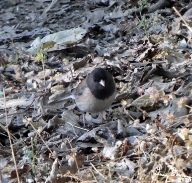
Early Morning Junko

Hummingbird

Hummingbirds on feeder

Bee getting his tan


Flowers and Plants

A few flowers coloring our world