1I did not start the GPS until about an eighth of a mile into the trip. Previous mileages was around 1 3/4 miles.
I am always mesmerized by this tree
Description: Before heading to our church's family camp out at Aspen Hollow Group Campground near Hume Lake, Sherri and I stop at Big Stump for lunch-we had Subway sandwiches. Since we were looking for a short hike, this one seems to fit the bill. We have hiked this several times before both by ourselves, with kids and with others. It is a good hike for us, particularly when we lack time to do something more extensive.
One of the problems with doing something so often is you think you know the area. Consequently, I do not observe as much as I wish. On this trip we sort of pushed through the hike without really stopping to enjoy it, not saying that the walk isn't enjoyable, it is. But this is a place of history, where giant millennium old trees were chopped down. Usually something like this will cause me to consider what may we be doing today which is similar to what these folks were doing in the name of progress.
Big Stump Meadow
The trail leads us down into the Big Stump Meadow area. We then see the stumps and remains of trees. There is a side trail to a place which is called the feather bed. It is a trough they lined with boughs to cushion the fall of a tree-not that it did any good. Many trees still shattered. At the end of the meadow, our trail rises up to the road, close to the guard station.
We cross Highway 180 and continue around. We are no longer in the Big Stump area, but are able to see various rock formations, shrubs and trees-not too many Sequoias. A butterfly plays tag with us and then flies off. Sort of nice being close to the road and only being able to hear the traffic, but not see it. The trail is about 40-60' above the road until we come back to the Big Stump Parking Lot. There a culvert pipe takes us under highway 180 and up into the parking lot.
So off we go to complete our journey to Aspen Hollow. But as we go down 10 Mile Road we past Logger's Campground. There is a dirt road off to the side and we follow that. I had seen a trail on a map. But we never did find the trail, but found a few people target shooting.
Title: July 30, 2014 - Watchtower and Tokopah Falls
Trail head: Wolverton Parking Lot
Hike Info:
Type: Hiking
Trail: Lakes Trail
Destination: Watchtower
Distance: 6.59 miles
Start Time: 8:29
End Time: 1:24
Travel Time: 4:55 (1.34 mph)
Moving Time: 3:48 (1.73 mph)
Elevation Rise: 1,972'
Maximum Elevation: 8,910'
Description: When I think of a hike up to the Watchtower, I think of a good climb through forests and then a single place to find a sight worth the climb. But today, I got all of that and more.
I started the morning by stepping outside and immediately decided to go back inside. The sky was dark and clouds were ominous. So I went back inside to get my rain jacket. Now I am prepared, I think. On the drive to Kohl's, saw a couple flashes of lightening-well, maybe not all that prepared. At Kohl's, picked up Brian W and went ahead to load Bill and Richard on the way. Even driving up, we saw lightening flashing from the clouds down to earth. There was a few drops of water hitting my windshield. After a break at Big Stump, we traveled on to the Wolverton parking lot, the beginning of our hike.
Cathey and Audrey walking through meadow
This hike is nearly a consistent uphill coming in. We start with a good climb out of the parking lot until we meet the ridge overlooking Lodgepole. The word overlooking is a bit of an exaggeration as the view into the Tokopah Valley is mostly obstructed by trees. But that is OK since the trees have a tendency to keep this trail cool and are enjoyable to walk through, even in bright sunshine. But today, it is overcast with a bit of concern about rain, not that the rain ever shows up.
Now the more from above is this: surprisingly there are flowers presenting themselves, particularly in the meadows. Not so much surprising that there are flowers here, but that there are flowers here now, with as little water as we have had this year. There are some Columbines and Indian Paintbrushes. But also several varieties of whites and yellows, with blues. Just an eye opening time. There is more to this trail than just the Watchtower.
Across from the Watchtower
We reach the junction with the Panther Gap Trail-the same one we walked with the meetup group in mid-June. But we take a left, and shortly ignore the cross-over Hump Trail to Heather Lake. The rise is still moving us upward, but not as steep, until right before the Watchtower.
Once we climb a few switchbacks, the Tablelands open up for us. This is the area beyond the Watchtower in the upper Tokopah drainage. Just an amazingly inviting country. Sherri and I have done Pear and Moose Lakes. But the area beyond is calling me. We can see across to Silliman Crest and that area.
Tablelands
Watchtower cliff
John
The Watchtower is a place just to rest and cogitate, but not if you have vertigo. The trail brings you to the edge of a 1,100' drop straight down. Most of us enjoy the view, but from a distance at least six feet from the edge. The actual Watchtower is about a hundred feet across a chasm. Some of our group go around and climb up it and enjoy that sight.
Now it is time to return back to the cars for more fun. The return trip is backtracking along the trail we just came up. For some reason, it is easier to return going down. But somehow I am now feeling more tired. We get down just five hours after starting. Time for another walk, but this time gentler.
Trail head: Lodgepole Campground
Hike Info:
Type: Hiking
Trail: Tokopah Falls Trail
Destination: Tokopah Falls
Distance: 4.01 miles
Start Time: 1:46
End Time: 4:16
Travel Time: 2:30 (1.60 mph)
Moving Time: 2:08 (1.88 mph)
Elevation Rise: 502'
Maximum Elevation: 7,155'
The Watchtower
Description:
For the second part of the day, we scurry over to the Lodgepole Campground. There is a trail head inside the campground. So we park on the south side of the Marble Fork of the Kaweah River, cross the bridge. The entrance to the trail is just beyond the bridge on the north side. In case this sounds familiar, our meetup group did a hike in March to some falls on this fork.
The trail is gentle, at least compared to the Watchtower. So this does allow for conversations to occur, rather than the gasping for breath which happens on high altitude climbs. So I walk with a couple others and get into a conversation with Audrey, a third grade teacher with FUSD. Just a pleasant time to chat about people whom we both know.
Tokopah Falls, or trickle
Marble Fork of the Kaweah
But back to the trail. Towards the Falls, we get into granite blocks which we climb through. We come out to the trail's end, where the falls are. Or I should say, where the falls should be. But now there is only a trickle coming down. Sort of a disappointment in the falls. But as John said, you can just imagine how beautiful they would be-he is ever the optimist! People start to leave and I walk back with John and Cathey.
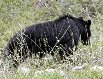
Bear Cub
The hike back is on the same trail. But it amazes me to see how different the same dirt can be going in a different direction. Just the trees and the creek and looking down valley have a different perspective. And a bear cub gently grazing for his huckleberries. Wait! A bear you say? Well really a cub about 30' from the trail. Several of us, and others, stop to gawk and take pictures. I was told that after I left mama and and another cub came up.
Grouse
Not much more after that, except for a grouse posing for a picture. We get back to the trail head and the car. Our car decides to continue back to Fresno rather than stopping for a bite to eat. I get back to home around 5:30.
Trail Lesson: Prepare to enjoy the beauty you do not expect.
Description:
I was somewhat thinking that this was not a hike I was going to be able to go on. With Twin Lakes being in a wilderness area, there is a group limit of 15 people and there was at least that many on the wait list to go. But then Betty's husband was not able to go and she offered me the opportunity to take Randy's spot-just for today. So I jumped at the chance.
Tiger Lily
Sometimes you do not expect too much out of a hike, besides a good excuse to go out and enjoy a walk in the mountains with people whom you enjoy. That is enough to get me out. And I was not expecting too much more than that. Having backpacked to George Lake before and been by Upper Twin Lake, I did not think I would be blown away by the scenery, which I was not. But as one of my trail lessons said, Beauty is there. Find it! It was not until I started looking at the pictures I took when I realized, beauty was all around me, I just needed to open my eyes and see it.
So today started with us gathering in Kohl's parking lot-14 of us showed up. John delineated the wilderness rules concerning group size. Then we all jumped into our cars and headed towards Huntington Lake, with a brief stop in Shaver for their bathrooms. In my car was Betty, Dennis and Rob-good conversations ranging from a lost hiker who had a broken leg to backpacking to enjoying Bass Lake.
We get to the Potter Pass trail head around 8:30. This is where the California Riding-Hiking Trail is bisected on the Kaiser Pass Road. We head north along it. We immediately start gaining altitude, but not on the scale which Sherri and I have been two weeks ago. Still, going up 300-400' in a mile is a good climb. It sot of shows as we are sweating a lot. Still, the day is young and we have energy.
Tiger Lily at Lower Twin Lake
Columbine
We shortly come to a place which will be one of the three things which exemplify this hike. This first item is a meadow, not just a lot of green grass with some corn lilies scattered in, even though there is that. In addition, we have a bounty of flowers showing off for us. Tiger Lilies, Columbines, Indian Paintbrushes, Queen Anne's Lace, and many others which keeps us in awe. Just this would be enough to make the trip a success.
Drops on leaves
As we climb up, we get to see a bit more around us. China Peak ski area is across the way, along with Huntington Lake. This is to be expected. But we see clouds drifting in and starting to billow upwards. I can gaze at clouds to my hearts contents. These clouds do not seem to be bringing rain-even though later on we will hear the report of thunder.
We stop on top of Potter Pass. From here on, it will be downhill to Twin Lakes. There is a nice little, unnamed meadow at the foot of the Pass and a good expansive view looking northwards to ranges about 10 miles away. But Potter is not one of those passes which you remember because of the vista, but because it is an entrance into someplace else, namely access to Twin and George Lakes.
So down we charge, with the knowledge that every step down means a climb back up. But the total drop to Lower Twin Lake is only about 400', not the 600-700' we climbed to get up here. As we drop, we encounter more meadows, even a named one, Round Meadow. But by now, we are ready to see some water, some good sized water. Lower Twin Lakes-why is it called lower? It is 2' higher, elevation wise than the upper lake. Lower Twin Lake does not disappoint. While not really notable as a lake, we are greeted with a reflection of peak 9659'. This is one of those close to picture perfect images.
Jerry
Kate
Jerry and Kate in for a swim
Then it is a short trip up a small rise to Upper Twin Lake. We hear people splashing, but do not see them for a few minutes. Then we see our group. Kate has entered the water and swam across to an island. Jerry is about to join her. Nobody else ventures to go to their island, but Meagan does enjoy a nice wade. But our attention is brought back to the island as both Kate and Jerry jump from a rock, splashing. Then returning back to our side of the world. They both look refreshed. This is the third characteristic of our hike, refreshment of the spirit.
Upper Twin Lake
Leaving Upper Twin Lake
Our return back is interrupted by a couple of things. First John talks to us about the possibility of returning to this area in a month or so. The idea is to continue on up to George Lake and up to Kaiser Peak. Then return back to Nat and Gerri's cabin at Huntington for eats. Sounds long, but interesting. I may plan a backpack trip up to George Lake at that time. It is a place I have enjoyed in the past.
Dinner, the Grouse
The second item is a grouse is spotted. So we now have not only wildflowers but a wild bird. Even though this bird does not seem to be too intimidated by us. I try calling the grouse over to me, "Here Dinner, Dinner, Dinner." But he does not seem to be interested in my culinary desires. The trip back to Potter Pass is not too bad-at least not as strenuous as I suspected it would be going down.
Cathey and John reach top of Potter Pass
At the top of Potter Pass, not only is our group waiting for us, but so is a group from Golden Eagle Camp resting before going down to Twin lakes. We had seen a group on a return trip going back to the parking lot on our way in. But now, it is all downhill. Instead of pulling up the rear, I get into a conversation with Kate about her recent trip to Whitney. Then I get to hear a discussion on Meagan's and Richard's profession for much of the rest of the way down. But there is still time to look at a cone and try to determine where it came from-turns out to be a Noble Fir.
We get down to the car around 2:20 and wait around for 15 minutes for the rest of our group. At the end of the walk down, we started to hear the boom of thunder off towards Edison. The sounds of thunder crackling continue as we wait, but does not seem to be drawing any closer. Also no moisture to cool us off. Then it is off to Shaver Lake for pizza. We get back to Fresno around 5:15. A good day to be hiking.
Trail Lesson:
Beauty is all around me, just open my eyes and see it.
1Distance, elevation gained and times are approximate. My GPS' batteries died after 10 minutes on this hike.
Description: For such a short walk, tonight's walk packed a lot of punch. It was started last month when our meetup group did Taft Point and Sentinel Dome as a day hike. It was Kate's first time on top of Sentinel Dome and she was very impressed. So Sherri and I told her about doing this as a full moon hike. Excitement abounded, so we made arrangements to do it during the full moon in July.
Roger and Arida
In the meantime, we invited several others who we thought would be interested. So we had a group of 13 people, consistent of Sherri, Steven and I; Carol, Peter J, Roger and Arida-from house church; Kate, Jerry J, Shawn and Bill from our meetup group. Also Roger and Arida had relatives visiting from the Netherlands, so Gerrit and Krystal came along as well.
Our group gathered at our house at 4:30. By 5:30 we were at Todd's in Oakhurst. This may have been a mistake, not because the food wasn't great, but because it was. We still had an hour-plus to drive to our trail-head on roads which are curvey. Plus we dropped a couple of cars in Oakhurst and we had a bit of logistics on where to park-this caused a bit of delay. But we get to our trail-head about 7:45, ready to walk. Our trail-head is not the normal Sentinel Dome trail-head, but about 3/4 of a mile further down the Glacier Point Road. Why here? There is an old road which lead up to Sentinel Dome-I remember Dad driving it when I was a child. Because it is an old road, walking it at night should be easier and shorter on our trip back. The parking area is pretty full, but we find places for all three vehicles.
Sunset beside Sentinel Dome
The path to the base of Sentinel Dome is pretty good. Our group has various levels of abilities, which is good. It is not fun being with only "expert" walkers. The altitude gives some of us issues since we come from essentially sea level at Fresno. But the views give us reason to stop. As we approach the base of the dome, the sun starts setting and we get a glorious view.
But the sun is not the only place giving us a good view. Half Dome and Clouds Rest bask in the sun's fading light which gives these landmarks a gentle rose color.
Half Dome and Clouds Rest glowing
We do the climb up Sentinel Dome slow and steady-at least some of us did. We create our own switchbacks by zip-zagging up the Dome's northern slope. We see we are not alone as there are about 20-30 people up here besides ourselves. Once on top, we are immediately rewarded with the last glow of color to the west of us.
Final glow of sunset
Moonrise over the Clark Range
Then we see a faint glow coming up over the Clark Range. Then as the glow intensifies, we are treated to the moon breaking above the mountain tops. The pictures I took just do not show the greatness of the sight. Somebody mentions it is like ET appearing. In my mind, that is a drab comparison. We all are in awe of the beauty we see on top. We stay up on top of the dome for over an hour before we realize we need to get back to Fresno.
Moon Rise over Clark Range by Shawn S
We head back to the cars, making it down without incidence. This way up in the dark is a winner. I arrive at the cars at 10. We get off and stop in Oakhurst to retrieve cars. It is 12:15am by the time we get to my house, tired but in great contentment. Kate says this is the best of her life. While I have seen a lot of beauty this year, let alone of my life, I do agree that this is memorable.