Showing posts with label Devils Dance Floor. Show all posts

Wednesday, March 3, 2021

March 3, 2021 - Badger Pass


Title: March 3, 2021 - Badger Pass
Hike Info : DescriptionExtra Photo's 

Trail head:  Badger Pass Parking Lot
Hike Info:
Type: Snowshoeing
Trail: Glacier Point Road, Dewey Point Ridge Trail
Destination: Top Knoll on Ridge Trail
Distance:  2.60 miles 1
 
Start Time: 12:45
End Time:    3:51
Travel Time:  3:05 (0.84 mph)
Moving Time:  2:01 (1.29 mph)
Elevation Rise:  486'
Descent: 482‘
Maximum Elevation: 7,648'
GPS Tracks
 1Tracks are from the Garmin 60csx instead of my wrist GPS, a Foretex 401.
Description:

Sherri getting snowshoes on
Once again it is just Sherri and myself. Rose and Betty have other obligations. But unlike last week, we are a little bit better prepared. We are going up to Badger Pass area, about a two hour ride. We probably should have gotten a little earlier start than 10:15.

On the way up, we talk some about truth. Yes, there is that Truth which as a Christian, I believe is Jesus and from which all other truth derives from. But in this day of our culture, we do have a lot of different perceptions about what truth looks like. This may depend on who is speaking, at least that is what I see. If it is one of our political leaders or even religious leaders speaking, we tend to evaluate the “truth” of what they are saying by our own perceptions. And then Sherri got a good one in about someone’s“truth” coming out of their ass. I had just read in the Old Testament of this exact thing happening. Sherri did not see the humor in that.


This keeps us occupied for most of the trip up to Yosemite, stopping briefly in
Wawona, arriving at Badger Pass around 12:15. We ate our lunch in the car, got on our snowshoes and were off by 12:45.

The day looks a bit dismal. Cloudy skies, but the forecast only calls for cold. It was 37o

The Knoll We Will Climb
when we stepped away from the car. I had asked Sherri how energetic does she feel? Not too much of a definite answer. So we will play it by ear. Our initial route is up the Glacier Point Road. This is the main passageway for most winter travelers. You can tell that it is: cold, not snowed in over a month and many people have traveled this route. How might you ask? Over half of the road is pretty hard and another couple of degrees, it would be very hard to travel without spikes of some type.


Mt Hoffman

We go up the road about half a mile till we reach the top. This is the dividing ridge between
Grouse Creek to the west and Bridalveil Creek to the east. Here I ask Sherri the same question, how energetic are you? She said that she would follow me. So after we walked over a 5’ diameter fallen tree, we headed on the Ridge Trail for Dewey Point.

The Ridge Trail is a difficult route for cross-country skiers. The trail dances between trees and has several bumps. Also in a few places it is steep enough that we see where the skiers have side stepped up slopes. Then to add to the “fun” trees are down from a windstorm a month and half ago. But as snowshoers, we only had to contend with going up the hill-a bit of huffing and puffing. Also because of the lack of snow, time and narrowness of the ;ath, any ski tracks have been nearly wiped out. So no need to show proper etiquette and avoid ski tracks.


Gary
We get to the top of where the trail goes. There is a nice area without trees. But at the end is still the forest, blocking a good deal of the view. Still through openings we can see Mt Hoffman, North Dome and Clouds Rest. From here, the trail will slope down to Dewey Point. But do we really want to go down there? Particularly with pretty limited time?

The answer is No. Instead we climb a little ways to the top of the knoll. It is a fun walk on snow with only a track or two. We do not use the tracks to guide us. When we get to the top, I make a comment to Sherri that the “view from here is almost beautiful”. This is not knocking the area, there is a quietness, serenity being in the snow with no one else area. There is a quietness which is unbroken by humans, except for ourselves. But the almost beautiful comment is that I can see where El Cap is, but not really able to see it, or the Devil’s Dance Floor-ditto. It is like that and if it was not for the trees, the vista would be magnificent! Do I not want the trees? I certain do want them-I just want both: the trees and the view!


Burnt Trees sheared off by the wind

We start down the slope, but instead of heading east to the trail, we go more south, following the ridge down. Very nice going over snow which is neither too icy or too soft. We hit another patch where the trees are all dead from a fire. But when? I was initially guessing that part of the
Ferguson Fire in 2018 may have been the culprit. But looking at where the fire stopped shows several miles away to the west. A Yosemite Fire history map shows a fire hitting the area in the 1980’s and then again in the 1990’s. This may have been the Steamboat Fire of 1990.

Recently downed trees
The other question is, did the January Mono Winds top all these trees at about 20’? There are logs all around, mostly under the snow. But now and again, we see a log uncovered on top. Has that tree fallen during the past month? It makes me eye the trees around us a bit closer.

But it does not change our route, well, we do weave our way around the fallen logs not covered by snow. But this is a pleasure. We keep looking at the Clark Range to the east and Horse Ridge to the south, where Ostrander Lake is. It is even a better view than on top, still not unobstructed. Enjoyable and we gawk for a while. 


 I am concerned about how steep the slope back down to Glacier Point Road. When we went by it coming in, it looked pretty steep. But there is a nice ravine to the southwest side which we follow down. This is fun! We make it down to the road. And now it is a half mile back to the car, downhill. So it is much easier. Two backpackers pass us going in. We talk for a minute before they go on.

By the time we get to the car, it is right about 4pm. We stopped in Oakhurst for a burger at Carl’s Jr. Then back home, arriving at 6:30, just in time for our Wednesday night family Zoom time. A good day


Extra Photo's

North Dome


Looking across to the Cascade Drainage and the Devil's Dance Hall

Tree on top of knoll

Sherri

Interesting looking stumps

Horse Ridge

Horse Ridge

Clark Range

Sheared Off Trees

Horse Ridge


Tuesday, April 8, 2014

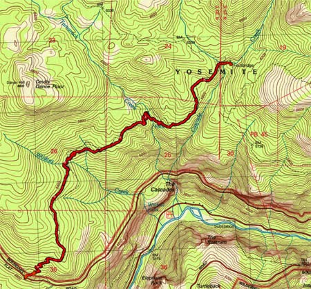
April 8, 2014 - Cascade Creek

Title: April 8,2014 - Cascade Creek
Trail head: Foresta
Hike Info:
Type:  /Backpacking
Trail: Parts of Rim Trail
Destination: Cascade Creek
Distance:  4.65 miles
Start Time:  11:31
End Time:     3:46
Travel Time: 4:14 (1.10 mph)
Moving Time: 2:50 (1.64 mph)
Elevation Rise:  1,709'
Maximum Elevation: 6,144'
Description:

We started out planning this hike to take people who have not been backpacking before. But things did not work out, so the remaining sojourners are Andrea, Sherri, and myself. But that is good too because we get to spend time with our daughter.  The other change in plans was the location. Almost no snow all winter. But last week a couple of feet dumped in the Sierra's-which is a good thing. But our original destination up Alder Creek has more snow than I want to camp in. For years I had been eyeballing a trail out of Foresta. This is not a summer-time trail as there is a lot of exposure to a sun. Even today with it being 90 in Fresno, it will be warm on the first part.
On the way up to meet Andrea, we had an incident. We stopped in Oakhurst to pick up a Subway sandwich, which by the way, we have had good success in stopping here. This time is no different. But when I open up the bear canister to put the sandwiches in, a strong scent of wine, along with a bit of light purple appeared. Our wine bag had sprung a leak. Lots of stuff in the canister was wet and some of it leaked onto my shirt and pack. After using the Subway bathroom to clean up the mess-thanks Subway-we were able to leave. At the entrance station we examined the pack. We just needed to clean up a bit more, but most everything, except for the pack had not been affected. So we are off to meet Andrea.
We got to the trail-head a little after 11, over an hour late. Andrea had gotten here at 9, so she has had a long wait. The first order of business is to repack my backpack after making sure there was nothing affected by the wine flood of 2014. Then we are off, around 11:30.
Dead Forest
Tamarack Falls
After crossing the road, we started our climb. While today is warm, this trail could have been a lot hotter. We sweat a lot-some of it gets into my eyes. But we continue on up this initial climb. The A-Rock fire1 of 1990 came through this area and the area is still recovering (since writing this, I found out that a fire came through in 2009). For the first miles, there are only burnt tree trunks still standing. There is old dried up manzanita bushes which show some signs of life-that is besides the grasses and a few wildflowers. Maybe as compensation, we see some falls by Tamarack Creek in the distance.
After a mile and a half of this, being under the noon sun, we see the first signs of forests, firs it looked like with some incense cedars. Wildcat Creek is close by. We see the Dance Hall and the Devil's Dance Floor at the end of Wildcat. Now this trail is looking a bit more like a Sierra trail. After crossing Wildcat Creek, we stop for lunch. Not too bad of a place, just enjoying the mountain air to enjoy our Subway sandwiches.


Andrea&Gary after Tamarack Creek

Tamarack Creek


Enjoying the hike
But now it is onward. We have down the major part of our climb so it is more of a relaxed pace. With us being under the trees, the walking is nice, the uphill is moderate, conversation flows freely, but being the afternoon, we are a bit warm. But that changes in a few minutes. Except for the slope of the hillside, you would not realize you are just a quarter-mile above some of the falls of Yosemite-not the famous ones, but the ones Wildcat, Tamarack and Cascade Creeks create.


Sherri
But this comes to an end-not the conversation or steep hillside, but the warmth. We need to cross Tamarack Creek. As much as we scout around for a place to cross, Andrea only finds a suitable place to cross-without her pack. Sherri and I take off our boots and wade across. That snow-fed creek is COLD! Certainly no thought about how warm the air is. We get dried off and start on our way again. Now it is less than a mile to Cascade Creek. I am a bit concerned about crossing this creek, just because of its size and I think I have read in a blog how this guy had to travel a ways to find a way around it.

Cascade Creek
But we come to Cascade and find a bridge, and snow. It is getting later in the afternoon. A bit too soon to stop. But looking at the map the next water is four miles away after a pretty good climb. Also this snow is spooking me so I think it is better to camp here. There is a nice spot to stay, with a good fire pit, close to the creek. So camp we do.


Wanderings
After pitching the tent and looking around a bit, we go for a short wander up towards Tamarack Flat along an old road. It turns out this is part of the historic Old Big Oak Flat Road. We do not get very far, maybe a third of a mile when we are stopped once again by Tamarack Creek. With snow all around it, we decide to cross it, but to head a bit towards Cascade Creek on our way down. Just wandering, nothing spectacular.


Sherri, Andrea, Gary enjoying the fires
Dinner is the other half of our Subway sandwich. Andrea brings along split pea soup, which tastes good warm. A fire is started and the evening air turns chilly with the setting of the sun. We wait until we can see stars--well I do not wait, but fall asleep while seated by the fire. But it is nice just being here, enjoying the companionship of wife and daughter.

Hike Info:
Type:  Hiking
Trail: Tamarack Flat Road and wandering
Destination: Cascade Creek
Distance: 1.12 miles
Start Time:   4:46
End Time:    5:39
Travel Time: 0:52 (1.29 mph)
Moving Time: 0:41 (1.64 mph)
Elevation Rise: 265'
Maximum Elevation: 6,261'

 1There are several interesting references to this fire. It appears that not only did A-Rock fire burn this area in 1990, but also the Big Meadow controlled burn in 2009. For more references, see the following links:


  • Tributary
    Falls along tributary


Sunday, January 4, 1970

Place: CA-Devils Dance Floor


Devil's Dance Floor (El Capitan)
(Long, Lat)

Description:


Trips:


References:
Pictures: