Showing posts with label Pinchot Pass. Show all posts

Wednesday, July 17, 2013

July 17, 2013 - Trail Camp


Title: July 17, 2013 - Trail Camp

Hike Info:

Trail: John Muir Trail

Starting location:  Guitar lake
Destination:  Whitney Portal
Actual Destination:  Trail Camp
Distance:   9.21
Start Time:  6:03am
End Time:  6:50pm
Travel Time:  12:47 (0.72 mph)
Moving Time: 6:52 (1.34  mph)  1
Elevation Rise: 3,336'  1
Maximum Elevation:  14,506'


Description:

Psalm 19:1-4 (NIV), from today's quiet time:

The heavens declare the glory of God;
    the skies proclaim the work of his hands.
Day after day they pour forth speech;
    night after night they reveal knowledge.
They have no speech, they use no words;
    no sound is heard from them.
Yet their voice goes out into all the earth,
    their words to the ends of the world.
In the heavens God has pitched a tent for the sun.

These words seem so appropriate, so right after all which we have seen and done. May my spirit offer the same words and praise.


The Night Sky silouetted by the top of the Sierras


I woke up at 2:30 to seeing the stars dance in the heavens. Then I turned over and saw lights on the move up past us, and on up to the mountains which we will climb today. My mind must have been excited as I could not return back to sleep for more than just a few minutes. 


Morning has broken
Sherri woke up around 3:30. I asked her if she was ready to start walking? No. But neither could she go back to sleep. So we laid there, watching the stars and lights, and thinking about how cold it was outside of our sleeping bags. Finally around 4:30, we got up and got packed. Just a wonderful sunrise, on the faraway peaks-rosy, orange and light. But we will not feel the warmth for several hours as Whitney and its range will be blocking the sun.

Guitar Lake
E'gads! Our propane canister has run out of fuel. Or is it just too cold? Whichever way, I am now glad we asked for Talia's canister back at Le Conte. Her canister fired right up and we had hot oatmeal on this cold morning.

Left our campsite at 6 and started up the long trail to Trail Crest. We will be in shadows all the way to Trail Crest.  Like the Tolkien song says, The Road Goes Ever Onward. But today is our last day on the Trail. Tonight Steven will pick us up, assuming we can make it down to Whitney Portal. Showers and burgers fill my mind as we walk along.

The trail is going up is strong and the oxygen is light.  This has us stopping for breath in the cold air, but the coolness does have the positive effect of having move along. Not really sweating. Before we know it, we have climbed up 500', then a thousand. I start playing a game of saying which pass we have just topped-Glen Pass, then Pinchot, Mather, Muir, and finally, of course, Forester.
Hitchcock Lake

We rise above Hitchcock Lakes, admiring the reflections of the rocks rising from the lakes. The sun is  shining on these slopes, creating a bright spots on our climb. We stop a couple of times to take off our packs. At 9, three things happens: we come out into the light, John B from Fresno appears, and we arrive at Trail Crest. All three are welcome, even though in a little while, the first will be less so. 

Trail up the side of the mountain
At Trail Crest, which is really about 200' below the actual pass, but the JMT does not go through the pass on its way up to Whitney. After unloading some of Sherri's pack and putting the contents into mine, we take off towards Whitney, with Sherri's pack, stocked with food and water. It took us three hours go from Guitar to Trail Crest. It will take close to three hours from Trail Crest to Whitney. 


Almost to the top
The climb up is along a trail which is always rocky, sometimes a bit narrow, and is perched on a steep incline for much of the way. Today was a light traffic day. When Sherri was up here before, the line could have been at Disneyland. You add in that the Badwater to Whitney Portal run ended today, you get a fair amount of trail runners as well. One sort of skidded in front of us, after passing us. He flopped around, trying to right himself, before realizing how close to the edge he was. But for us, we took our time and was cautious.  As we approached the top, the altitude was taking its toll on us. We stopped more and more often to catch our breath. We felt relieved as we turned the corner, and started up the third of a mile incline up to the peak. Many others were stopping and breathing along the way.

Smithsonian Hut

At the top (36.57886, -118.29185), we found the Whitney hut, actually called the Smithsonian Institute Hut. It was constructed to observe a solar eclipse. In the trail registry, we saw that the Ray and Rachel had made it to the top on Monday, July 15th. It was good to see that. But we did not see an entry for Nicole.


The Top
Celebration


Also on top, we see John from Fresno, along with George, Chris and Steve from Minnesota. Sort of like a family reunion. We talk for awhile. After much trying, got to send a text with our picture. Also Spot worked as well. 

That is when things got interesting. Called up Steven. He said that Andrea was coming in from the High Sierra Trail to surprise us. She would be there Thursday night, and climb over Whitney Friday. At least that is what her schedule is. That is a big surprise. What a wonderful daughter to think of us, and want to make our lives a joy. 

This does lead to one complication-what do we do now? Go back to Guitar Lake? Go down to Lone Pine tonight? Stop someplace else? We decide to stop on the trail down. We were not up to doing the climb out of Guitar again.

We called other family members, telling them we made it to the top. Also, that we have now officially completed the JMT, It is fun doing that--also fun just saying that. Got through to all, except Andrea, of course. David does say that not all of our Spot messages got through. The Minnesota group decides to leave the party after awhile. We talk with John for awhile longer, then he heads off as well.

Gary, King of the World


We stay on top for a total of an hour and a half, then start coming back down. It is faster-not as much need to catch our breath. But you do feel weaker, so we do not move very fast. Also with the rocky surface we have a tendency to be careful.

Whitney from the east
We rest at Trail Crest before we start our way down in the Lone Pine direction. We will try to make Outpost Camp tonight. Did I say down? The first little bit is another 200' climb, before we start our descent. Then down we go. Down, and down, and still more down. They have re-engineered this from seven years ago. I do not know, but Sherri  remembers a different trail. But the steepness, once again causes us to be cautious, so we go slow, about a mile an hour. Seems strange that we are going at the same speed down something as up it.


Trail Camp is by the pond
Around 6:30 we get into Trail Camp(36.56314, -118.27943) Sherri remembers this place as being human turd infested. But it looks like the Forest Service has cleaned it up quite a bit. As tired as we are, we decide not to do another two miles down to Outpost Camp. We find a suitable place. Then on the way to get water, a better place. Dinner is cooked. We see George, Chris and Steve a little ways from us and exchange greetings. Then it is off to bed. We look at pictures and fall asleep, knowing we do not need to get up early  tomorrow.

You may have noticed, that the description from the top does not contain these jaw dropping thoughts and observations. I guess by the time we got there, it just does not match up to the rest of the journey. It is the end, and that makes it special. it is wonderful to see the mountains upon mountains, looking down on everything around us. the cold, blue lakes, the barren landscape. but there is not a specialness to the place for me, like there is around some of the other high places we have been too. Even a lowly pass like Island, I have more desire to be at. I am not saying that I wish I was not here, but that the enjoyment is in the completion of the journey, rather than in the place. Do we think we will go up there again? Probably not.

Today's JMT Lesson: It does not matter how fast you go, as long as you get there.


 Breakfast Lunch Dinner Snacks
Oatmeal and add-ins, such as dried peaches, strawberries, nuts, granola. Tang. Peanut Butter and Nutella on crackers Beef Vegetable Wrap
Milano Mint Chocolate Cookies
Clif Bar, Jelly Bellies, CytoMax, Propel, GORP, Bank Balls


 1The supplied figures above come from either the book John Muir Trail: The essential guide to hiking America's most famous trail by Elizabeth Wenk or from topo maps. There was only partial tracks for today in my GPS. Below is the readings from today's status on the GPS. I view it as only somewhat accurate.
Distance:  9.41 miles
Elevation Rise:  1,805'
Maximum Elevation: 14,505'


On the trail up


The Windows and Mt Muir from Whitney


Trail down to Trail Camp


Marmot Heaven


Friday, July 12, 2013

July 12, 2013 - Woods Creek Crossing


Title: July 12, 2013 - Woods Creek Crossing

Hike Info:
Trail: John Muir Trail
Starting location:   Bench Lake Ranger Station 
Destination:   Wood's Creek Bridge
Distance:     10.3 miles*  1
Start Time:  8:10
End Time:   5:30
Travel Time:  9:20 (1.10 mph)
Moving Time: 5.31 (1.87 mph)*
Elevation Rise:    1,350' *  1
Maximum Elevation:  12,130'

*GPS was off for about 40 minutes while coming down Pinchot Pass, about .9 miles

Description:
It is cold, wet and glorious. This is what greeted us this morning. Cold-so cold my fingers were turning numb-but the water did not freeze. Wet-from the dew. The tent is wet, both inside and outside of the rain fly. My sleeping bag has gotten damp. And glorious, blue sky, rose colored mountains, turning to the color of light, meeting on the peaks over our heads. It seems appropriate that my hymn of the day is Be Thou My Vision.2 Sherri slept uncomfortably. There was a bit too much slope to the site, causing her to roll off her bag. The sleeping bag and pad would roll with her.

Looking back towards the South Fork of the Kings
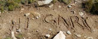
Left camp around 8:10. We made good time to Marjorie Lake. At Marjorie, Ray and Rachel left a"Hi Gary" on the trail. Makes me so happy. Then it is the start of our real climb up Pinchot Pass. We stop at 11,500' for  a break and a Clif bar. Again at 11,900' we stop and break-we have gotten awfully good with practicing these breaks. Saw Larry and Paul at one of the breaks on this climb.

Marjorie Lake
Marmot keeping watch
This is what I love about the High Sierras. The blue and green lakes and tarns, surrounded by mountains rising out of the earth to the sky. The far away peaks are a vision. As Sherri says, we have to work for this. Would I want it any other way? Would I love it if we whizzed by it in a car?

Made it to the top of Pinchot Pass a little before noon. This pass turned into a real party! Paul and Larry came up shortly after we arrive. Then three PCTers came up. Finally a lone JMTer arrived. After we all talked for awhile, found out the lone hiker was John B, from our meetup group in Fresno. Talked some on the way down. He is a professor at Fresno State and should be meeting Lori's group tomorrow at East Lake.

John B, Sherri and Gary on top of Pinchot Pass
Went down part way with John B. Then needed to stop. John went off on his way. But Larry and Paul catch up with us and we hop scotch with them down the trail, the rest of the way to Woods Creek. Earlier, my GPS ran out of batteries, so I lost about a mile of data. Also found out my iPad is not charging. Not sure why.

The way down after steep part of Pinchot is plain old long and hot-there is no cloud cover today to keep the sun from our skin. We actually pass Larry and Paul today-Sherri is listening to Fleetwood Mac. This certainly speeds things up our pace!

We stop at Sawmill Pass trail junction. Larry and Paul join us. Larry is having an issue with his iPad mini and it wanting him to backup to the iCloud-fat chance of this out here, or for the next week or so. We figure out how to do a reset by holding down the Sleep and Home keys for about ten seconds. Success.

Woods Creek
On our way down the last 3.9 miles, it seems like it goes on forever. In reality, it just drops 2000' in those miles. It is rocky and uncomfortable and just OK as far as beauty, at least compared to the rest of the Trail. Finally the Golden Gate of the Sierras brings us joy. In case you do not know what it it is, this bridge is a single person at a time, swaying suspension bridge across Woods Creek. A fun amusement park ride for those who like such things. A quarter of a mile later, we cross it, bringing us into one of those large congregation of JMT camps (36.87289, -118.43515)

Many others are camped here. Larry and Paul come in a little while later, at a camp a bit lower than ours. Both of us are tired and do not move very fast. But the tent gets put up after being aired out. Water is drawn and dinner is cooked. About the same time as we finish, Larry and Paul join us with their food. We talk and eat the rest of the evening. Larry loans me his battery pack and I get a charge on my iPad. By the time we get to bed, it is 9:20-no McGyver tonight.
Towards Rae Lakes and Glen Pass
 
Today's JMT Lesson:  You need to work to get to see beauty.


 Breakfast Lunch Dinner Snacks
Oatmeal and add-ins, such as dried peaches, strawberries, nuts, granola. Tang. Peanut Butter and Nutella on crackers Beef and Cabbage Wrap Clif Bar, Jelly Bellies, CytoMax, Propel, GORP, Bank Balls


 1The supplied figures above come from either the book John Muir Trail: The essential guide to hiking America's most famous trail by Elizabeth Wenk or from topo maps. There was only partial tracks for today in my GPS. Below is the readings from today's status on the GPS. I view it as only somewhat accurate.
Distance:  9.6 miles
Elevation Rise:  1,926'
Maximum Elevation: 12,130'


Marjorie Lake from Pinchot Pass
2Be Though My Vision
Naught be all else to me, save that Thou art
Thou my best Thought, by day or by night,
Waking or sleeping, Thy presence my light.

Be Thou my Wisdom, and Thou my true Word;
I ever with Thee and Thou with me, Lord;
Thou my great Father, I Thy true son;
Thou in me dwelling, and I with Thee one.

Be Thou my battle Shield, Sword for the fight;
Be Thou my Dignity, Thou my Delight;
Thou my soul’s Shelter, Thou my high Tower:
Raise Thou me heavenward, O Power of my power.

Riches I heed not, nor man’s empty praise,
Thou mine Inheritance, now and always:
Thou and Thou only, first in my heart,
High King of Heaven, my Treasure Thou art.

High King of Heaven, my victory won,
May I reach Heaven’s joys, O bright Heaven’s Sun!
Heart of my own heart, whatever befall,

Still be my Vision, O Ruler of all.

Heading towards Woods Creek


Heading towards Pinchot


South from Pinchot Pass


Falls on Woods Creek


Friday, January 16, 1970

Place: CA-Pinchot


Pinchot, Mount (Mt Whitney),  13,470'
Pinchot Pass (Mt Whitney),  
(Long, Lat)

Description:
Occupied as triangulation station in 1905 by members of the U.S.G.S. This was the first ascent. (J. N. Le Conte.—Gannett: Results of Primary Triangulation and Primary Traverse, Fiscal Year 1905-6, U.S.G.S. Bulletin no. 310, 1907, p. 162.)

“Only five miles south [from summit of Split Mountain] there stood a great rounded mass of red slate on the Main Crest, and I allowed myself to change the name Red Mountain given it by Professor Brown [S.C.B., 1896, I:8, p. 309], and already applied to scores of the slate peaks of the Sierra, to Mount Pinchot.” (J. N. Le Conte, in S.C.B., 1903, IV: p. 362.)

Gifford Pinchot; chief of Division of Forestry, U. S. Department of Agriculture (afterwards called Bureau of Forestry, and, later, U. S. Forest Service), 1898-1910; born in Connecticut, 1865; A.B., Yale, 1889; LL.D., McGill, 1909; professor of forestry, Yale; governor of Pennsylvania since 1923.
from Place Names of the High Sierra (1926) by Francis P. Farquhar

Trips:
  • July 12, 2013 - JMT Trip with Sherri and Gary
  • July 2007 - JMT Trip with Sherri and Andrea

Pictures:


References:
  •