Showing posts with label Whitney. Show all posts

Saturday, August 17, 2019

August 17, 2019 - Buena Vista Peak


Title: August 17, 2019 - Buena Vista Peak
Hike Info : Description : Extra Photo's : Animals : Flowers and Plants
Hike Info:
Type: Hiking
Trail: Buena Vista Peak
Destination: Buena Vista Peak
Distance:  2.34 miles
Start Time: 5:18pm
End Time:   7:04pm
Travel Time:  1:46 (1.32 mph)
Moving Time:  1:12 (1.94 mph)
Elevation Rise:  577'  1
Descent: 610‘
Maximum Elevation: 7,589'
 1The elevation on the GPS did not record correctly. The elevations here is from Google Earth.
Description:
Sherri and I were to be out camping by now. But having an extra day at Delilah put a crimp in that. Then I got a call and said there was a problem in the sale of my parent's house. So I am having to do some research. Do we still want to? Can we actually go up and at least do a hike? Yes, lets get some dirt on our feet-it turns out getting dirty is easier said than done. But the things with my parent’s estate had me looking all morning for some documents.


We left Fresno at1:45. First, we needed gas. So off to the new Costco we go. Then we head to Grant Grove, still not sure what trail to go on. But we will stop at the Visitor Center to check on what is open. There, we ask about the Boole Tree-closed. Then, what about Little Boulder Creek-it is most likely open. So off we go down Burton Road. It is a pleasant drive. But today, there is much more traffic than our usual-which is nobody else taking my road. But they do look like they are trying to find a place to 4-wheel drive.
We travel down Burton Road, aaaah and ooohing about the scenery, but wanting to get on the trail. Sherri and I have been on this one with Rose a couple of years ago and really enjoyed it. But the area has been closed now for the past couple of years. We round a big curve and what do we see? A gate, blocking our progress to the trailhead. There is a sign which says we would need to walk about 2½ miles to even get on the trail, let alone walk it. Since it is about 4, this will not work out. So much for Little Boulder Creek being open. We back track, stopping along the way to view the Kings River and beyond.
But the star attraction today will be Buck Rock. When we turn our gaze from the Kings, the lookout stands stately, high above us, like a queen ruling the sky. It turns out that today, she will be our companion in our travels. No matter where we turn, there she is.


When we get back to Quail Flat, we make a decision: we would still like to hike and Buena Vista Peak is just down the road. So this will be our hike for today-pretty short, still a hike. As we get ready at the trailhead, I spot a Sequoia Forest truck go by us-it is Patrol 33 who we know.
Mt Sillman


Our hike starts a little after 5pm. Steven charges ahead; Sherri and I lag behind. Maybe it is the length of the day so far or just not having walked in awhile, but this hike is pushing me- I would classify this as an easy hike or slightly above, suitable for most people. I am breathing a bit more than I should. I am just glad that Sherri is also stopping as well. Still it is wonderful being out. Buck Rock comes into view-I told you it was her day. We are escorted on the way up with some late blooming flowers-no pictures, sorry. As we close in on the top, a hiker comes down. We chat for awhile-he is planning on doing Whitney in a week or so and has been training. We talk about different places. He asks about a peak to the southeast-it looks like Mt Sillman to me-not Whitney. He is carrying bear-spray. I do comment that he may want to find out how legal it is to carry the spray in the park-later I look and it is not. He is concerned about cougars/mountain lions.
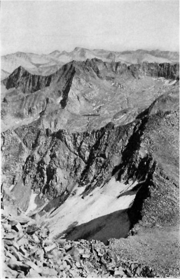
 View from the top
Then we are off and reach the top in short order. Here we just enjoy the view. It is very hazy as we look West towards the Valley, but pretty nice the rest of our viewing direction. One of the good things about this peak is you have a 360 view. If you know where to look you can see Park Ridge, but not Delilah. After awhile, it is time to move on.


The trip down is a lot faster and easier. My stride returns to more of a normal length and cadence. A few places it is easy to mistake a place where others have gone for the trail-this is what happens with Sherri. But we all make it down OK.

Now where do we eat? We decide on DNC in Grant Grove. It has been enjoyable for the last couple of years, but just a bit slow. When we get there, the wait staff looks frazzled. A couple large groups are in. But we get a table fairly quickly. The food is adequate, but the waitress is very scattered-Steven never gets his water after asking twice and a refill of ice tea for me only gets done when she gives us the bill.
We make it down the hill to Fresno. Sherri and I are having a debate about where certain lights we are seeing from Delilah are. One set of lights we find are from a warehouse just north of the airport. The other set, we are not sure about. But Steven shows us where the water tower is at Fresno State. We get home about 9:50. I take a shower and climb into bed.


Extra Photo's


Park Ridge Lookout in shiloeuette

Tree at Sunset with Big Baldy

Steven's selfie

Walking Man Steven

Sherri and the trail
Oddities

 
Tall Woman Shadow


Stick Through a Tree

Star Wars invasion on top of Buena Vista Peak


Animals


Flowers and Plants


Sierra Daisy

Cow Parsley


Friday, January 23, 1970

Place: CA, Mt Whitney


Mt Whitney-14,475' (Mount Whitney) (36.5784890, -118.2919407)
Whitney Meadow-9,708' (Johnson Peak) (
36.4321589 -118.2664763)
Whitney Creek-7,835' (Mount Kaweah) (36.5513258, -118.4037029)
Whitney Portal-7,871' (Mount Langley) (36.5888232, -118.2259237)


From Up and Down California by William Brewer     
MOUNT WHITNEY, IN DISTANCE
AS SEEN FROM THE SLOPE OF MOUNT BREWER
From a photograph by Ansel F. Hall
Description:

Josiah Dwight Whitney (1819-1896); born Northampton, Massachusetts; A.B., Yale, 1839; New Hampshire State Geological Survey, 1840-1841; Geological Survey of Lake Superior, 1847-1850; Geological Surveys of Iowa and Wisconsin, 1855-1857; State Geologist and chief of California State Geological Survey, 1860-1874; professor of geology, Harvard, 1865-1896; LL.D., Yale, 1870. (Brewster: Life and Letters of Josiah Dwight Whitney, 1909, portrait.—Portrait in S.C.B., 1925, XII:2, plate XLIV.)

In July, 1864, a field party of the California State Geological Survey under William H. Brewer, with Charles F. Hoffmann, James T. Gardiner, and Clarence King, saw from Mount Brewer the main crest of the Sierra a few miles away. One peak they named Mount Tyndall. “The other high point, eight miles south of Mount Tyndall, and, so far as known, the culminating peak of the Sierra, was named by the party Mount Whitney.” (Whitney Survey: Geology, 1865, p. 382.)

“Whitney had forbidden his subordinates to name for him the mountain which is now called after the Rev. Lorentine Hamilton. This time, in their chief’s absence, they stood upon their rights of discovery, and called their great peak, Mt. Whitney.” (Brewster: Life and Letters of Josiah Dwight Whitney, 1909, p. 238.)

“For years our chief, Professor Whitney, has made brave campaigns into the unknown realm of Nature. Against low prejudice and dull indifference he has led the survey of California onward to success. There stand for him two monuments,—one a great report made by his own hand; another the loftiest peak in the Union, begun for him in the planet’s youth and sculptured of enduring granite by the slow hand of time.” (Clarence King: Mountaineering in the Sierra Nevada, 1872, pp. 280-281.)

Clarence King attempted to reach the summit of Mount Whitney in 1864, but failed by a few hundred feet. (Whitney Survey: Geology, 1865, pp. 388-391.) In 1871, King climbed what he supposed to be Mount Whitney and published an account of the ascent. (King: Mountaineering in the Sierra Nevada, 1872, pp. 264-281.) On July 27, 1873, W. A. Goodyear and M. W. Belshaw rode mules to the summit of the supposed Mount Whitney and perceived that a peak a few miles north was higher. King, upon learning of his mistake, hastened to the Sierra and ascended the true Mount Whitney, on September 19, 1873, but not before it had several times been ascended by residents of Owens Valley. (King: Mountaineering in the Sierra Nevada, 4th edition, 1874, pp. 281-297; James D. Hague, in Overland, November, 1873.)
First ascent, August 18, 1873, by John Lucas, Charles D. Begole, A. H. Johnson, all of Inyo County. They endeavored unsuccessfully to affix the name “Fisherman’s Peak.” (Wheeler: U. S. Geographical Surveys West of the 100th Meridian, I, Geographical Report, 1889, p. 100.)

Occupied by scientific party under Samuel Pierrepont Langley, of the Allegheny Observatory, August and September, 1881, for observations on solar heat. (Langley: Researches on Solar Heat. Professional Papers of the Signal Service, no. XV, 1884.) Occupied by parties from Smithsonian Institution and Lick Observatory, 1903, 1908, 1909, 1910, 1913. (S.C.B., 1904, V:2, pp. 87-97; S.C.B., 1910, VII:3, pp. 141-148; Annual Report of the Smithsonian Institution, 1910, pp. 65-66.)

For other records, accounts, and discussions of ascents, see: W. A. Goodyear, in Proceedings of the California Academy of Sciences, 1873-1874, V, pp. 139-144, 173-175.—W. A. Goodyear: letter to the editor of Inyo Independent, July 30, 1888, reprinted in Eighth Annual Report of the State Mineralogist, 1888, pp. 230-232.—Badè: Life and Letters of John Muir, I, 1923, pp. 392-396.— W. C. Wyckhoff: Sunlight Mysteries, in Harper’s, June, 1883, pp. 81-94.—Frank Adams: Up Whitney by the Lone Pine Trail, in Sunset, June-July, 1906, pp. 74-80.— J. N. Le Conte: The High Sierra of California, in Alpina Americana, no. 1, American Alpine Club, 1907.—Appalachia, January, 1892, VI:4, pp. 285-288; May, 1903, X:2, pp. 135-142.— Mount Whitney Club Journal, Visalia, California, 1902, 1903, 1904, nos. 1, 2, 3.— S.C.B., 1893, I:1, pp. 1-8; 1896, I:7, pp. 290-292; 1903, IV:4, pp. 289-290; 1904, V:1, pp. 60-63 1904, V:2, pp. 87-101, 138-139; 1905, V:3, pp. 258-260; 1905, V:4, pp. 316-317 1909, VII:2, pp. 105-118; 1910, VII:3, pp. 141-148; 1910, VII:4, p. 248; 1911 VIII:2, pp. 137-138; 1922, XI:3, pp. 253-254.— Farquhar: Exploration of the Sierra Nevada, in California Historical Society Quarterly, March, 1925, IV:1, pp. 32-36, 38.

“A military reservation of a certain number of legal subdivisions surrounding this peak has been declared by authority of the President [Arthur] in General Orders no. 67, of the War Department, September 26, 1883. It is understood that this reservation is for the purpose of securing the location for a prospective Signal Service station.” (Wheeler: U. S. Geographical Surveys West of the 100th Meridian, I, Geographical Report 1889, p. 101.—Map of proposed reservation, in Langley: Researches on Solar Heat. Professional Papers of the Signal Service, no. XV, 1884.)

Altitude determined in 1905 by R. B. Marshall, U.S.G.S., a fraction over 14,501 feet. The highest point in the United States exclusive of Alaska. (R. B. Marshall.)  From Place Names of the High Sierra (1926) by Francis P. Farquhar

They [King and "Dick" Cotter] reached the summit of Mount Tyndall (14,025 feet) and from that point beheld and named Mount Williamson (14,384 feet) and Mount Whitney (14,496 feet). Lack of provisions prevented an attempt to reach the latter. From Up and Down California by William Brewer, Book 5 Chapter 2

On this occasion King reached the mountain, but made a bad choice of routes and failed to attain the summit. The first ascent was not made until 1873. For a further account of Clarence King’s efforts, see Francis P. Farquhar, “The Story of Mount Whitney,” in  Sierra Club Bulletin,  XIV, No. 1 (February, 1929).         From Up and Down California by William Brewer, Book 5 Chapter 2 footnote 10

From GNIS:
  • Whitney Meadow:
    • In Golden Trout Wilderness, at Golden Trout Creek and Stokes Stringer, 5.1 km (3.2 mi) east of Rocky Basin Lakes and 14.1 km (8.9 mi) north of Kern Peak.
    •  Also called:
      • Big Whitney Meadow
      • Golden Trout Meadow-almost named this, but there was strong testimony against renaming it.
      • Whitney Creek Meadows: Browning, Peter. Place Names of the Sierra Nevada. Berkeley, California: Wilderness Press, 1986. p238
      • Whitney Meadows 
  • Whitney Creek: In Sequoia National Park, heads at an unnamed lake on the west slope of Mount Russell and flows southwest to join the Kern River in Kern Canyon 3.5 km (2.2 mi) northeast of Red Spur.
  •  Mount Whitney:
    • Highest elevation in California at 14494 feet, 1.3 km (0.8 mi) south of Mount Russell and 1.4 km (0.9 mi) north of Mount Muir.
    • Proposal to change name to Mount Churchill rejected by Board on Geographic Names (BGN) September 14, 1965.
    • Also called:
      • Fisherman's Peak
      • Fishermans Peak
      • Mount Churchill: Proposed name to honor Winston Churchill upon his death. Canada had named a high mountain after President Kennedy so a citizen thought it was fitting to name our highest peak after Churchill. This was rejected.
  • Whitney Portal
    • Former name of Hunter Flat, for William L Hunter, one of the early pioneers of Owens Valley, who made the first ascent of Mount Williams in 1884. This feature was called Whitney Portal at the official opening of the automobile road to the flat in June 1936.
    • On Lone Pine Creek, 4.8 km (3 mi) east of Mount Whitney.
    • Also called Hunter Flat


Trips:
  • June 26, 2014 - Ten day trip along the High Sierra Trail and Colby Pass-crossed Whitney Creek


Pictures: