Title: July 29, 2012
– Davis Lake to Goddard Canyon
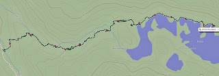 Trail head: Davis Lake
Hike Info:
Trail: Cross-Country
Destination: Goddard Canyon and maybe
a little beyond
Actual Destination: Goddard Canyon

Distance: 5.8 miles
Travel Time: 12:30
Moving Time: 4:32
Elevation Rise: 1,098'
Maximum Elevation: 11,175'
Description:

Got up at first light and hit the trail at 7:30. More boulders and
more slow moving. Sherri has gained some experience and is moving
better. As we move along the lake, we realize just how huge this lake
is. Also with the mountain backdrop, how breath-taking this area is.
Davis Lake is so clear and we are the only ones here.


This part of my journal is written from memory. I was so tired,
that it was hard for me to put pen to paper and have the words come
out intelligible. Once free of the boulder field—Andrea and I did
continue our system of ferrying Sherri's pack, we rested. We have not
gone far, but there has been a lot of effort. Now we are faced with a
talus slope of at least 30-40 degrees. And this is a long stretch.
But once across this stretch, we should be in good shape. It turns
out that once we climb about a hundred feet or so, there is a pathway
across the talus slope. And it is pretty level without much give
under our feet.

At the end of talus field, we are about three-quarters of the way
around the lake, but we will be leaving the lake here. There is a
small saddle above us. But before this, we get a splendid view across
from where we came. The lake is below us by several hundred feet—from
this height you can see almost everything about it. We would not be
able to continue on around the lake on our side because of the cliffs
coming down to the lake and the falls on the other side. The other
side of the lake has even more impressive cliffs. So it is up and
over the saddle.
This is easier to do on the map than in reality. We start climbing
up the saddle and think we are following a cross country trail—in
retrospect, we probably are, but when we come across a ridge, it
looks like the path will take us on a pretty shear path, one which I
am not sure I want to walk on. So we stop at this pond close to the
saddle. It is idyllic. If we had enough food and time, I would say
camp here. The pond is really deep—you cannot see the bottom, even
though the water clear. We have lunch on a strip of grass and just
enjoy the soft breeze blowing. But we need to continue on and we have
much of the afternoon left.

I go on and find an easy, bouldering path over the saddle. My
memory of this area after 40 years is shot and the things I remember
is not very reliable. But after crossing this saddle, we have a nice
easy meadow to go down for a quarter mile. But at the end, there is a
steep drop, maybe 400'??? down. While it looks manageable, it will be
slow going. There is one place where we need to take care and just go
down a handhold at a time. Andrea is doing double work by ferrying
Sherri's pack. But down we get.
And when we do, it is beside Goddard Creek—this is not to be
confused with Goddard Canyon which has the San Joaquin River running
down it. Goddard Creek empties Davis Lake and we are coming out below
the falls which does the emptying. There is a large sloping meadow
here and our only task is to cross the creek to get to the other
side, then it should be easy walking for a ways.

Andrea finds some rocks to cross, but Sherri is unsure about this,
so I go a little farther up creek to see what I can see. Out of the
corner of my eye, I see movement and a flapping of wings next to the
falls. When I look over, this bird has a huge wingspan. My guess from
the distance I am—150 yards or so—the the wingspan if 5-6'. It
has swooped down onto the south side of the creek. The head is white
and the body looks black. Sounds like a bald eagle to me. After a
minute or so on one side, it flaps up and lands on the north side of
the creek. I suspect it has caught a fish. After a minute, it flies
away. Unfortunately, I could not get the camera focused on the bird
and only got a blurry shot of him flying off.

By this time, Sherri and Andrea have crossed the creek and
excitedly join them. They have a small bird chirping close to
them—which I get a good picture of. But I can only tell them about
the eagle. It is now more down the creek time and the canyon we are
in is getting steeper. I see where I think we probably crossed 40
years ago. But this is after we have had another good slope to
descend. But on this descent I do find a broken plant and a foot
print. So at least someone else has been down this way. We cross a
little river-let and it looks like there is almost a path. This leads
us on for a ways—right up the side of a cliff. There definitely is
a path here which others have taken, but where it goes from here, we
are at a loss. After examining the options, we decide, there is a
small crack in the rock and Andrea goes up it. She says that we can
descend on the other side. So off comes our packs and we push them on
up. Sherri has her first chimney under her belt now.

But it is getting late and we are at least a mile, cross-country
from the Goddard Canyon trail. We decide that if we do not get down
by 8, we will camp. We start our descent again—this time, it is a
lot tamer from what we have gone on. But it tame only in comparison.
It is still rough. We go up and over a second ridge—this time it is
easy. We are able to look into Goddard Canyon and the San Joaquin
River. Now the only task is to get down. Andrea leads the way and I
work as a guide for Sherri. For the most part, it is more just
picking our way down. And down we get as we reach the river at 8.
Andrea finds a place to camp—or did I? Anyway, we start pitching
the tent and hammock in the dark while Sherri cooks our meal. We will
find the trail tomorrow. We turn in pretty much as soon as after we
eat, all tired from yesterday.
Note: I found the trail—I went out to relieve myself and found
the path.


 But it is not time for us to start our cross-country adventure. We
will be going up to a small 11,700' saddle and then drop down into
Davis Lakes. 40 years since I have been here. We make it up to the
saddle pretty good. Sherri's asthma does not kick in. But now we
start going down. It is a boulder field all the way down to Davis
Lakes and Sherri does not like it. The mountains are a good backdrop
and anytime we want to breath, they are there to admire—ie, a good
excuse for me to stop and breath.
But it is not time for us to start our cross-country adventure. We
will be going up to a small 11,700' saddle and then drop down into
Davis Lakes. 40 years since I have been here. We make it up to the
saddle pretty good. Sherri's asthma does not kick in. But now we
start going down. It is a boulder field all the way down to Davis
Lakes and Sherri does not like it. The mountains are a good backdrop
and anytime we want to breath, they are there to admire—ie, a good
excuse for me to stop and breath.


