Tuesday, June 19, 2012

June 19, 2012, Tuolumne Meadows to Glen Aulin and McGee Lake


Title: June 19, 2012, Tuolumne Meadows to Glen Aulin and McGee Lake
Trail head: Lembert Dome
Hike Info:
Trail: Pacific Crest Trail
Destination: Glen Aulin/McGee Lake
Distance: 6.3 miles (lost the GPS track)
Travel Time: 4:15

Description:
Last night we went to bed, pretty late, actually almost in the morning. I woke up at 6, turned over and got up 45 minutes later. Everything in my pack was ready by 8. But we are having troubles with Sherri's. She is taking the food this time, getting everything in her pack, including the food canister. This was the half height, Bear Vault. But after struggling for over an hour, we did get everything in, including changing it out for our Garcia canister-it is thinner.


After gassing up, we left Fresno. Got our wilderness permit at Wawona for Glen Aulin. Inquired about the John Muir Trail—an early permit can be obtained at 11am, previous day—it is better to get the permit in the Valley—they had first priority over the Valley trails.


We get held up with road construction at Wawona Tunnel. Finally make it to Tuolumne Meadows at 1pm. That is a long drive. Andrea has a friend doing the PCT--Maya. We thought that she was approaching Tuolumne Meadows Wednesday. Turned out she was there a week before. Oh well. I did ask some PCTers who were lounging around the Tuolume store if they had heard of Maya. They had not, but now that I read her log, I can understand.


We get started at 2 from the Lembert Dome stables parking lot. Sherri has some new boots on. So I carry her old boots in case these do not work out. The trail is wide and splits off of the John Muir Trail, which goes past Soda Springs and Parson Lodge. Our trail follows the Pacific Crest Trail northwest ward. We break away from Tuolumne Meadows and climb a little ridge. Delaney Creek is just over the ridge. This creek has provided us much entertainment. The coupe of times we have gone a ways on this trail, this creek has been our ending destination. Glen Aulin draws many people who normally do not step into the alpine air of Yosemite. Consequently, they sometimes have issues with some of the simple tasks of of hiking—such as crossing a creek. Most accept help, many are scared of falling in, some try to cross on their own. It is an interesting study of human nature.


We make it across the creek by walking on stones—the creek is not very high and this is a drought year. Our travel continues. We shortly come back to the Tuolumne River. This time, if anything, it is more meandering and wider than around Tuolumne Meadows. The mountains in the background and the meadows by river, fair weather under warm blue skies—we could stay here forever.


We stop for a lunch break by one of the scenic spots—that is not saying much since they are all scenic. Enjoying 20 minutes or more of paradise. After lunch we cross some large glaciated granite. And then we cross the Tuolumne River, that is on a foot bridge. It would have been fun crossing this river by wading it.


We shortly start down a good slope, which we will continue till we reach Glen Aulin. As we look to the right, we see Tuolumne Falls cascading down. My comment—this is at least as good as Spokane Falls. Sherri's response—better, God made it.


As we continue down, we see the White Cascades—soooo good. This is a wondrous trail.


We get to Glen Aulin junction, about a quarter of a mile from Glen Aulin itself. The NPS would like us to camp a mile from Glen Aulin. So we have a decision to make: continue on the PCT and go up Cold Creek on the other side of Glen Aulin; go down the Tuolumne River for about a mile; or go to left to McGee Lake. At the end of the decision, we go to McGee Lake mostly because it is on our trail Thursday. On the map, it is rather uninviting, but it does have the virtue of cutting off a little distance Thursday. Also Wednesday we will take a day hike down the Tuolumne River and see the Falls.


So to McGee we go. For the past 20 minutes, we have been attacked by a swarm of mosquito’s. So out comes the repellant. Much better. Shortly we get to McGee Lake. We drop our packs and I search for a place to camp. There is a place close to where we dropped our packs, but it looks a bit infested with pests. So I go the length of the lake looking for a spot—we are alone at this lake. Finally after walking the full third of a mile of the lake I find a place. Returning to Sherri and the packs, I hear a voice calling me from on high. Not a mystical calling, but Sherri with a revelation. She had gone on a bathroom run and found a perfectly good camp spot just 40 yards from where we dropped the packs. It is on top of a rock outcropping, higher up than most misquotes are willing to climb. So here we stay, 30' above the lake. We drop our packs for the final time today at 6:15.


Dinner is lasagna-freeze dried variety. Tasty, but a bit liquidy. We put some Ritz crackers to firm it up. Its clean up time and then into bed to escape the flying pests. I read my current book, Dracula, for awhile and turn off the light at 8:30.


Friday, June 15, 2012

June 15, 2012, Park Ridge Trail


Title: June 15, 2012, Park Ridge Trail
Trail head: Panoramic Point Parking Lot
Hike Info:
Trail: Park Ridge Trail
Destination: Park Ridge Lookout
Distance: 5.5 miles
Travel Time: 4:23 ( 1.25mph)
Moving Time: 2:38 (2.08mph)
Elevation Rise: 1,210'
Maximum Elevation: 7,743

Description:
We get a late start, leaving the house around 10:15 and getting up to the Panoramic Point parking area around 11:30. We then dawdle around for another half an hour before hitting the trail. The first 300 yards or so is a paved path up to Panoramic Point. From here we can see that there is a lot of haze and smog restricting the view. Also there are some thunderheads in the distance, but they will not be bothering us today.


From here we take the Park Ridge Trail. This trail follows Park Ridge—a bit redundant isn't this? From parts of the path, you look down into the Grant Grove, Lake Sequoia basin and the Central Valley. On a clear day, you can see the tops of the Coastal Range. Today is not one of those. On the other side, you look down onto Hume Lake, the South Fork of the Kings River and across to the tops of the Sierra's. This view can be breathtaking—but once again, not today. Too much restriction on visibility.


As we walk up and down the ridge, we do get to enjoy the birds swooping from tree to tree. But they are over-shadowed by the dancing butterflies. The tiger swallow tails are everywhere, along with blues, checkers and others which I do not know. The site of them brings a sense of awe and serenity to the place. This scene replays itself throughout the trail, making for a visually satisfying day.


We eat lunch when we cross an access road. We have just descended down a long a hill on the ridge and come to the Azalea Trail junction. It is a pleasant overview of the Grant Grove area. We have new fare for lunch-Pita bread, cheese sticks and peperoni sticks. Rather plain—seems like it needs something more.


We take off and read the end of the Park Ridge Trail—when we come to the Park Ridge Lookout. When Steven and I have hiked this trail before, the lookout had been unmanned. But now, there are two volunteers up there. We find out that it is their first day there. This lookout and the Delilah lookout are staffed with volunteers from the Buck Rock Foundation. We spend an enjoyable time talking with the ladies. We then return to the car via the same route we came on, arriving back at the car at 4:10pm. An alternative route would have been to return via the access road.


Tuesday, June 12, 2012

June 12, 2012, Watchtower


Trail head: Wolverton
Hike Info:
Trail: Lakes Trail
Destination: heather Lake
Actual Destination: Watchtower
Distance: 7.1
Travel Time: 5:01
Moving Time: 3:35
Elevation Rise: 2,537 – maybe exaggerated by 200'
Maximum Elevation: 8,8908
Description:
Whenever we have done this hike, I have Jimi Hendrix's version of All Along The Watchtower running through my brain. Not that the two are the same or even related.


We get up to the Wolverton parking lot, near Lodgepole around noon. We make good progress. There are three 20 something year old “boys” from Oceanside which we meet up with. Two of them must be the first time out—one of them does not have a backpack and has things bundled with a rope. As we go along, we play leap frog with them. The trail goes along the spine of a ridge separating Wolverton from the Topokah Valley. So you get glimpses of the valley—nothing special, but tantalizing. Someplace I drop the GPS and it loses track of where we are and how high up we are.


Just before we get to the trail junction with the Panther Gap, we meet a couple of girls. They tell us that a mother bear and her two cubs are a bit nervous when other hikers have passed them by. This is on the Hump Trail. It is giving us pause to consider about using the Hump today.


The Hump Trail and the Watchtower Trail are both part of the Lakes Trail. The Lakes Trail goes to Heather, Emerald, Astor and Pear Lakes. All jewels of lakes in along this trail. Pear Lake I count as my first real backpacking trip with my Dad. It is a trip which helped me fall in love with the High Sierra.


But enough about past trips. We break for lunch around 1 about 40 yards from the junction. We are trying out dried peanut butter mix from Bell Plantation. It is ok, but it lacks a little something. We dip our crackers in Nutella and the peanut butter is now tasty. Isn't that true of almost everything Nutella touches?


We then meet a girl—another 20 something by our creek. She takes pictures of all sorts of things. Then quietly moves on. The boys have not caught up with us yet. We pack up and go on and quickly come to the junction. By this time, we have climbed 900+' in 1.8 miles. After the junction, we continue to climb nicely. We come to the junction with the hump. We decide that we will forget about Heather Lake and the Hump and go to the Watchtower. We play leapfrog with the girl now that we have lost track of the boys. We finally catch up with her for the final time at the Watchtower. We all admire the view—up and down the Topokah Valley. You see the full view of the falls and then on up to the Tablelands. Just a good view of the High Sierra's.


We talk with the girl—never finding out her name. But she is a ranger at Lodgepole. No hat or uniform on, so no ranger picture. She is from Ohio. We do invite her over when she comes down to Fresno for supplies.


She goes on to Heather, we return down the trail. The boys have caught up with us and Sherri gives them some sunscreen. They are thankful. I note that it is a lot easier going down the trail, than up it. Sherri comments she was going to say that, but did not want to look like a wimp—guess that leaves me with the wimp title. We quickly make it back down to the car, around 5pm. Then off to Fresno and dinner at Casa Quinterio.


Monday, June 11, 2012

June 11, 2012 - Lewis Creek Trail


Trail head: Cedar Valley
Hike Info:
Trail: Lewis Creek
Destination: Sugar Pine
Distance: 7.6 miles
Travel Time: 4:21, 1.75mph
Moving Time: 3:50, 2.00mph
Elevation Rise: 1,414
Maximum Elevation: 4,291

Description:
If you head north on highway 41, about halfway between Fresno and Yosemite is the town of Oakhurst. It is mostly a tourist town with commuters to Fresno. Traveling just a few miles more on 41, you will see, if you keep your eyes sharply open, a little side road called Cedar Valley Road. Go up the road, about a mile and a half and to the left is a little pull out road, with a sign saying trail. Stop here—you have reached our trail head.


Now most guidebooks say to just continue down highway 41 until you reach a turnout with a trail sign. But that meets the trail only half way. Most people start here—and we have done this as well. But to hike the full length of the Lewis Creek National Scenic Trail—that's right it is a National Scenic Trail—use the Cedar Valley Road trail head.


The reason why this is a National Scenic Trail is the trail runs along the creek the full way, there is plenty of plant and animal life to keep you busy. Plus there are two very attractive falls to enjoy. Ann-Marie Brown in her book, California Waterfalls, describes as pure enjoyment. And they are. Corlieu Falls is a series of cascades over rocks and around greenery. But Red Rock is a 20 foot drop over a red rock—the redness of the rock needs to be seen during low water times.


Starting at Cedar Valley, the trail rolls along, through pines, cedars and wildflowers for the first mile—if done in Spring or early Summer. Then when you hit a campsite, by the creek, the trail starts a 500' ascent over the next mile—it feels like it is a lot more, at least my old legs feel like it is. Some of the feeling is that the ascent is done steeply, then levels off and then the climb starts again. But just when you start wondering where the top is, you see the bottom of Corlieu Falls. And it is a beauty to behold. Not all of the great falls in the area are found in Yosemite.


Corlieu Falls is named after Clifford Corlieu, a local personality. He did some ranching and mining over near Friant. But his daughter lived near Lewis Creek. Once he saw the area, he fell in love with it. He even set up a resort of sorts at the top of the falls—it is no more and there is no remains to be seen. Just a flat place.


After climbing to the top of the falls, you walk along the remains of an old logging flume walkway. You reach the trail coming in from the highway 41 trail head. We keep going and cross a log—with nice railings to get on the east side of Lewis Creek. For the most part, the trail still is gently rising. It continues to follow the old logging flume path. That is until right before Red Rock Falls, when there is a pretty good, but short rise, taking you to the top of the falls.


To view Red Rock Falls, take a the side trail about 200 feet down to the top of the falls. The better viewing place is the bottom of the falls and there is a side path down to the bottom. We enjoy a snack and then go back to the top of the trail. Most guide books have you go back down the trail. But if you really want to finish the trail, like we did, you go about half a mile of up and down walking to the Sugar Pine road.


The return trip is down the same trail, just reversing the route. As a note: the shorter version of this trip from Highway 41 is found in the Falcon Guide book, Best Easy Day Hikes: Fresno by Tracy Salcedo-Chourre, page 59.

Friday, May 25, 2012

May 25, 2012 - Blue Oak Trail


Trail head: South Bay Picnic area, Millerton
Hike Info:
Trail: Blue Oak Trail, also called the South Bay Trail
Destination: Winchell Cove
Distance: 3.5 Miles
Travel Time: 2:08
Moving Time: 1:22
Moving MPH: 2.5
Elevation Rise: 188'
Maximum Elevation: 638'


Description:
When I think of the Millerton Lake and Friant Dam area, I imagine a hot dry area with this man-made lake in the middle. Definitely do not think of excitement, coolness and enjoyment. But that is exactly with we got on this trail. The coolness was fortunate, since Fresno temperatures was exceeding 90 degrees a few days earlier and this trail and area can be like an oven on a hot day.


We knew this was going to be a special day from the first few steps on the trail. A small eagle, yes I did say an eagle, swooped down and landed 10 yards in front of us. He stayed there, or close by for a good 25 minutes before flying away. Excitement!


But that was not all. With a front coming through the area, the weather was cooler than we had any right to expect. But also, the front brought in some soaring clouds to march past our trail. This make for a constantly changing view. The lake turned from mundane to magnificent. Instead of hot and dry, it was cool, breezy and comfortable.


Our walk continued along the south shore of Millerton, After about 45 minutes of leisurely walking, we made it to Winchell Cove. The boats were all set for the Memorial Day weekend. While we could go about a quarter mile further on the other side of the boat launch area, we decided, just to turn around and go back the way we came.


Over all, the trail is easy walking, on a hard beaten clay. The grasses give you wide berth and the trail is about as level as you can get—Looking at the trial profile, I have seen more activity on seismographs. Oaks give visual entertainment. This is definitely a Fall, Winter, Spring hike rather than a Summer hike—unless you hit it on a day like today.


Thursday, May 24, 2012

May 24, 2012 - Tunnel Monument


Trail head: Pacheco State Park Parking Lot
Hike Info:
Trail: Pig Pond to Tunnel Monument back to Parking Lot
Destination: Tunnel Monument
Distance: 4.0 miles
Travel Time: 1:38
Moving Time: 1:21
Speed: 2.9 mph
Elevation Rise: 771'
Maximum Elevation: 1,1918'


Description:
Sometimes when you go past a place all your life, you realize that you do not know the area. For me, this is true of Pacheco Pass. Even before moving to Fresno, I had gone over this pass as a little boy, being driven by my parents from the Bay Area to the Sierra's. And when we moved to Fresno, we would drive this 152 at least once a month, and a lot of times more often. So last year when we were looking for hikes which we could do for Capture California, We noticed this little state park right on Pacheco Pass, Pacheco State Park. Unfortunately, we had not stopped here until today. This is definitely will change. While not a place to hike during a summer afternoon, it can be picturesque with oak trees, rolling hills, wind turbines and San Luis Reservoir filling the views.


Today, I was coming back from my parents in the Bay Area and hit the pass in the early afternoon. The day was warm, but not hot. So I decided, today is the day to see this area. Turned off of 152 close to the top of the pass and headed down Dinosaur Point Road. Yes there really was a dinosaur remains found in the area, well maybe. I was looking for a trail head off this road, but I did not pay enough attention to my map which said to take a right on Whisky Flat Road—that is the correct spelling of Whisky. So I went all the way down to the boat launch at Dinosaur Point. This was where I was in for a treat.


I was greeted by the boat inspector—for tag-along mussels. After receiving confirmation that I should have turned a ways back, we chatted for awhile, that would be over an hour. Evidently Manny is visited by a number of people who think this area is a great for partying and getting drunk. But he is out there because he enjoys viewing the wildlife-Tule Elk, mountain lion, mule deer, fox, and coyotes. We talked about the trails and the heat. He gave me some park brochures, which looking at them later, I realized I had most of it already. A woman and her mother stopped to ask some questions—looked like a husband in the car as well. They had traveled from Spain to see California. So after talking for a little while, they left. Manny and I talked a bit longer. He has written some books on poetry—The Bridge is Gone and The Elder, not famous yet. Yet it is exciting who you meet in places like this and then find out who they are. By this time, I was on my way to find the trail head—a few minutes before three.


Found the trail head, right next to a pen full of cattle. The Pacheco Family, through Paula Fatijo's bequeath in 1992, gave the State of California the property around Pacheco Pass for a state park. This was to preserve the area for its natural and human history. Consequently, they still do ranching operations, renting out part of the park. Also various wind farm operators also rent out part of the land.


Onward to the actual hike. The trail leaves the parking lot/corral area. Going toward the south. It is a gradually rising semi-jeep track—hardly used by jeeps, but used by hikers. Tall, dry, grasses abound, along with little critters. After a half of a mile, you come to a hundred foot ridge, cross it and find an intersection. I aim to come back to the intersection via the trail to the west, but for now, it is the easier trail to the south. We go up another small ridge and then drop down into a dried creek bed, which feeds into Pig Pond. And then the start of a more steep climb to the Tunnel Monument Trail Jct.


I take the Tunnel Monument Trail as that will give me a 3.5+ mile loop back to the car. My little talk with Manny cut short the hiking. But both the talking and the hiking are wonderful. This trail climbs up steeply over the next ¾ of a mile to the top of the ridge. As I reach the top, the wind whip's through rather fiercely, causing me to chase my hat. But the view is good. You see both sides of the coastal range. Westward there is the greener hills, which get the moisture from ocean breezes. Towards the east is San Luis Reservoir. And the windmills, furiously turning, trying to keep up with the wind. Such a far reaching sight.


When Manny and I were talking, we guessed what the Valley was like before modern man came along. The wildlife, the plants we would have seen. John Muir in Yosemite indicated the first time he came over Pacheco Pass he saw a carpet of bright orange flowers stretching from his feet to the feet of the Sierra's. Today, I cannot see Los Banos, let alone Yosemite. Things have changed.


But now it is time to find this Tunnel Monument. I go 50 steps back towards the car and there is a sign saying Tunnel Monument. But where is this monument? Where is this tunnel? Silly. I am standing on top of the tunnel—it is sunk several hundred feet below my toes. And the monument? Well it is a benchmark. This tunnel is the tunnel bore through the coastal range to drive more electric generators from the water coming from San Luis Reservoir. Nothing to see; just things to think about. How we can bore holes through mountains to move water, but not clean up the air we breath?


I start down the trail back to the car. The downward trail is steeper than I came up on. I come to a junction—but a different one than I saw before. But I take it anyway. It goes through part of the Pacheco Ranch and meets a private road. I go another quarter of a mile down the road and find my car. A most satisfying afternoon spent.


Wednesday, May 9, 2012

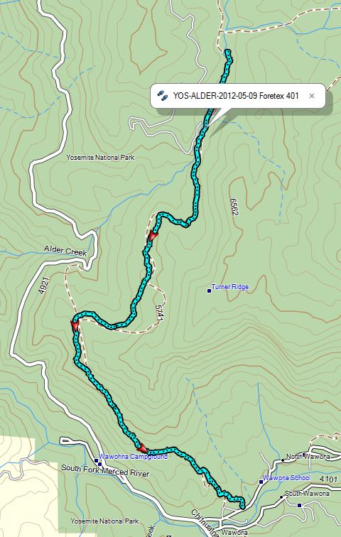
May 9, 2012 – Deer Camp and Return Trip, Alder Ck to Wawona


Starting Place: Alder Creek Crossing
Destination: Deer Camp
Actual Destination: Alder Creek Crossing
Miles Traveled: 3.0 miles
Elevation Rise: 770'
Travel Time: 2:30
Moving Time: 1:40


Starting Place: Alder Creek Crossing
Destination: Wawona
Miles Traveled: 7.2 miles
Elevation Rise: 233'
Travel Time: 3:20
Moving Time: 2:50


Slept under the stars last night. I was warm and comfy. The ground was at a slant, so you seemed to scoot down. Sherri was scooting around more than I. There was a nice moon out this morning—2am or so—almost full. Before then, the stars were bright until the moon showed up. Enjoyed watching both.

When I got up a dew had fallen, wetting our bags and everything else out in the open. I think Steven was dry in his hammock, between two trees. After walking around, I noticed the packs had a light frosting on them—must have been in the low thirty's.

Breakfast—oatmeal and granola, plus toppings. We sort of moseyed around camp for awhile, trying to make a decision on going on a day trip to Deer Camp or just to return back to the car. After much discussion, we will go on to Deer Camp, about a mile and half, one way.

We take off going up the side of Alder Creek—while the water was down a little, it still looked cold. None of us wanted in. So up the east side of the creek and cross-country for about a third of a mile, till we hit the trail. Lots of brush, lots of downed trees. But after awhile we meet up with the trail to Deer Camp.

It is a lot easier on the trail than the cross-country route we were taking. Even though there was a place where the trail fooled us. It did a switch back, but looked like it was going to go straight. So we took 10 minutes figuring this out and back-tracking to find the trail.

It is onward and upward. The trail goes long the side of the ridges, following the creek. We get to a small creek crossing. This is where Sherri and I could not cross several years ago—then there was lots of snow. But now, it is obvious how to cross it. We wonder what stopped us before—except for the snow.

We go another quarter of a mile and come to a little bigger crossing-still very crossable. But we have reached our check point time. So it is time to turn back. Wonder when we will be able to see this place, after all it is our fourth attempt. This time we are pretty near. None of the reasons to turn back was technical nor endurance, just we have to contend with other priorities.

The trip back to our camp is not very exciting. We did stop to build a snow man—a small one. Still it is a legit snow man. Sherri also gets a lesson in GPS usage.

When we get back to camp, we have lunch and then set out back to the car. We leave at 12:30—Sherri and Steven about 10 minutes before me. But it took me about an hour to catch up with them and I was going close to 3mph. So they were moving pretty strong.

Once we leave the evergreens with their overhead, the air gets hot. We drink water and lots of it. Sherri's Camel Back bladder goes dry. Steven's is close to empty. My canteen is down to half a cup when we finally reach the car.

On ward to Todd's. Great BBQ—had their special: Cajun Chicken Melt with Garlic Fries. Oh yeah—and lots and lots of ice tea. We get back to Fresno around 6, just very happy.

Tuesday, May 8, 2012

May 8, 2012 – Alder Creek


Starting Place: Wawona
Destination: Deer Camp
Actual Destination: Alder Creek Crossing
Miles Traveled: 8.2 miles
Elevation Rise: 2,568'
Travel Time: 8:50
Moving Time: 4:25


Got up a little before 6—must be getting ready for camp life. Sherri gets up at 6:30, while Steve drags himself out of bed at 7:15. We get a few last minute things ready and hit the door by 7:45.

We are going back up to Alder Creek. Hopefully making it past the falls this time. Should be warmer than last time. It has not rained since we last were up in mid-April.

We stop in Oakhurst to get Steven a Carl's Jr, Breakfast Burrito. We then stop at Wawona for a wilderness permit—which as it turns out, I leave in the car. We make it to the trail head around 9:40. Then hit the road a half an hour later. Much better than the last time we were up here.

Same trail, same sun on us. We go a third of mile when Sherri discovers she left her GPS on the hood of the car. Steven goes back to get it. Sherri and I continue on.

Dry heat with little breezes at time to cool us off. When we left the car, it was 70 degrees. At 11, after going 1.2 miles and 700' up, we stop for an elevense's break. After a few minutes, Steven catches up with us.

More uphill. I write a little while longer as Steven and Sherri continue on. I plod after them for about half an hour before catching up with them. We past the fallen log where we lost the GPS last time. At 12:15, we have our lunch, 2.8 miles into the trail-just a tenth of a mile from the Mosquito Creek trail junction. Usual fare of Ritz crackers, Peanut Butter and Nutella. We debate on how healthy can this be? My thinking, who cares? It tastes so good and we are doing so much work, it cannot be too bad.

While reading and resting, we saw a hawk gliding overhead, riding the warm air currents. It looks so graceful as he swoops and pivots and swoops again, free from visible effort. But we get no picture for Capture California.

1pm—we leave our lunch spot and start in. Shortly we come to the trail junction. After this it is a series of rolling hills, gradually going up. We pass our campsite from three weeks ago—completely free of snow. Three Falls is still flowing. After a spurt of up hill, we top out on the old railroad grade. From here, the trail is flat. You see remnants of old railroad ties. We stop at our creek to refill water bottles and take a break.

Then comes the highlight of the trip—Alder Falls. If Alder Falls was along a road or in the Valley, it would compete with Vernal and Nevada Falls. But you need to hike in 5 miles, climb 2,000' to enjoy this view—I like it that way. The effort makes the enjoyment that much better.

We look and gawk at the Falls. Then continue on, up Alder Creek. Then the railroad leaves us above the Falls. The trail is more single file. But gentle. We get to the creek crossing for Alder Creek. The snow runoff is going strong still. So we ponder our options. In the end, we decide to stop before crossing. We have gone 7 miles, with a gain of 2200' in four hours walking. Not bad. Of course, my brother would not let this stop him. (Later in talking with him, he thought that we were there to enjoy, not to show courage.) We have crossed this creek before, just as wet, just as wide. But it is just as cold now as then. I am getting more cautious in my old age.

The campsite has a pretty good tilt to it. We shall see if we roll down the slope tonight in our bags. I am so tired, I am not sure I would wake up. Sherri makes us Beef-Vegetable Wrap. It is always refreshing to have good food on the trail.

Now waiting for it to get dark and then it is to bed we go.

Sunday, May 6, 2012

May 6, 2012 - General's Highway to Panorama Pt


Hike Info:
Trail: General's Highway to Panorama Point
Distance: 3.0 miles
Duration: 1 hour, 25 minutes
Elevation Rise: 800'
Description:
Today we decided to do a short hike after church and mowing the lawn. So we left Fresno around 1:30, for the Grant Grove Area. We got there after 2:30. There was snow—old snow to be sure of—but snow just the same, around the visitor center.

We are doing a trail from the General's Highway to Panorama Point. It is technically a segment of the North Boundary Trail in Grant Grove portion of Kings Canyon National Park. But we have hiked this on its own just to enjoy the pleasure of the early season. It is a short hike, maybe three miles round trip with about an 800' elevation rise.

We pull in; get our REI Flash Packs ready, along with our hiking poles; put on the old boots, and then,a burning truck pulls into the turn-out where we are parked.

A man and two kids jump out and scoot away from the truck. Lots of smoke—Steven sees some flame—and there definitely are some popping sounds. Good thing he stopped.


Sherri and Steven went ahead, up the trail. I took the man and his children back to the Visitor Center. A ranger called for fire engines. It looks like I will need to find another place to park and meet Sherri and Steven.

So I drove up to the Panorama Pt parking lot and walked down the trail, expecting to meet Sherri and Steven on the way up. No sign of them, except for some footprints which looked like the tracks were going in the wrong direction.

Got close to the highway and saw foam, an ambulance, a fire truck and a tow truck. Exciting, as long as it was not my vehicle.

Coming back up the trail, I saw the reason why I missed them. There is an older, gentler trail, which I took down. But then, there is a newer, shorter, but steeper trail, following some power lines. Sherri and Steven had gone up the short trail. Looking at the GPS logs, I missed them by three minutes.
We caught up with each other at Panorama Point. On a clear day, you can see much of Kings Canyon's back-country. Such as North Palisades and Kersarge Pinnacles. Both of which Sherri and I will be passing by later on this summer when we do our JMT adventure in July. So it is a wonderful thing to see all the handiwork from this Point.


We came back to the car, 300 yards from the Point. And then headed back. Spring is in the air and the deer are scattered everywhere.

We ate Pizza in Squaw Valley—Bear Mountain Pizza and was back in Fresno by 7:15.