December 2012
What a year! It has been a season where we have experience a tremendous amount of fun and excitement. From making an annual pilgrimage to Denver to hiking our feet off in the Sierra's, to going foreign—just barely—to taking a plunge into the midst of the Pacific Ocean it has been a year not be missed.
Retiring when we did has been a blessing. It has given us the time to spend with Gary's parents. The timing of our retirement has fit in with the needs of our family. This year has been a year of several big milestones—Gary's Mom and Dad turned 90 years old and celebrated their 60 years together. Being able to bring together their friends to celebrate was exciting, fun and challenging. We also were able to take them to San Diego and visit Mom's sister. In addition, we went on two other trips with them. The first was to Victoria, British Columbia in June. This was a leisurely trip up the coast, enjoying the water and the cliffs. We went through the coastal part of Olympic NP-another place added to our list of future adventures. When we got to Victoria, a day was spent fulfilling one of Mom's dreams—seeing Buchart Gardens. It was well worth the trip. Another day we traveled around Victoria's water front. On our way back, we saw Dad's sister and family.
My brother's friend, Kevin, made his condo in Kona, Hawaii available to our parents and so the five of us took advantage of it, doing a week's stay on the Big Island. And what a week it was. Lava, coffee, and water, along with lush jungles and water falls! We got to snorkel for the first time-swimming with dolphins and sea turtles, little yellow fish and sea urchins, and go up over coral. It was worth the trip just for that. But, as the commercials say, there was more. David took us on a trip around the island, including stops at an out-of-this world bakery for some of the best bread we have eaten. Then there were black sand beaches, the lava beds extending into the ocean, and classic paradise like waterfalls—the visual is too much for my writing talent. In Hilo, we went up to Hawai'i Volcanoes NP and saw the Halemua'uma'u Crater with its active lava. But the week came to an end with us wanting to come back.
Most of you know we attempted the John Muir Trail, aka JMT. We made it 90 miles, about 8 miles beyond the Devil's Postpile. Eight days out we stopped because of a potential medical condition--it was better to be able to hike another day than to push forward. Once back, we got some medicines adjusted. But before turning back we saw some really DDG country—that is Drop Dead Gorgeous. Granite peaks with ice-blue Sierra lakes provided relaxation for our tired bodies and minds each night.
After turning around, we were back on the trail with Andrea for seven days. This time, we went out of Florence Lake up to the Evolution Valley area. We then headed cross-country for two days, camping by Davis Lakes—which Andrea claims is the most beautiful lake in the world. We then came back, it was down Goddard Canyon and back to Florence Lake. This recreated part of a route Gary did in his youth, 40+ years ago. This trip, which was made without incident, was more strenuous than the JMT we did earlier, so the medical issue was taken care of.
Speaking of our oldest daughter, we teamed up with her, becoming Team Thing One, Thing Two to play the Capture California game. It is a photo scavenger hunt, taking us from the Oregon border to San Diego, hiking, bagging all 21 missions, frolicking on beaches, and gaining an understanding of our State's history. How did we do? Out of the 250 teams signed up there was none who gathered more points than us. Its fun and free, so you might want to sign up for it next May.
So how are the kids doing, you might be asking? Rachel is still working as a live-in nanny in San Gabriel. But she is exploring career possibilities, but nothing definitive yet. While Steven is preparing for the possibility of going to Fresno State next year. As you can see, Andrea is still into her adventures and finding a permanent teaching job.
So what does this new year have in store for us? We do not think we will slow down too much. We hope to continue to spend a lot of time with Gary's parents, enjoying being with them and vacationing with them. Will we complete the JMT this year? (We are still deciding that one.) Rick Warren notes that service gives purpose to life. We continue to look for places of significance to pour our lives into.
Our prayer is that each of you will find new refreshment in our Lord this year.
Some online sites we maintain:
Sunday, December 16, 2012
Tuesday, September 11, 2012
September 11, 2012 – Grant Grove Area
Title: September 11,
2012 – Grant Grove Area
Trail head: Grant Grove Parking
Lot
Hike Info:
Trail: Sunset Trail, Dead Giant Loop,
North Grove Loop, General Grant Loop
Destination: Grant Grove Parking Lot
Distance: 6.9 miles
Travel Time:
Moving Time:
Elevation Rise:
Maximum Elevation:
Description:
We got to our camp spot in Grant Grove's Azela Campground--#19 to be specific—around 3:15. Got our tent pitched and everything ready by 3:45pm. Certainly is a slow process in getting packed when you have not gone camping in 3 months or more. But we are up here for the night.
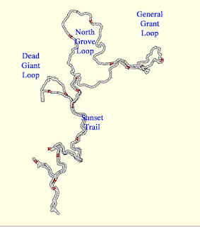
We went on four trails today, one which was incidental. The trails sort of lead into each other. There was the North Grove Trail, The Sunset Trail, The Dead Giant Loop and the General Grant Loop. These are trails which we are used to and do enjoy. Just a short drive from our home, yet strenuous enough to satisfy our need for exertion.
- North Grove Trail.
We start from the Grant Grove parking lot and go westward,
descending. Lots of sequoia trees which forms an overhead canopy.
But we are not on this trail very long before we turn off onto the
Sunset Trail. We will rejoin the North Grove Trail in a ways.
- Sunset Trail. This is more of a jeep road, or actually an old tourist road, which feels like it will lead us down to Lake Sequoia. But along the way, we branch off to follow the Dead Giant Loop.
- Dead Giant Loop. This loop starts from the Sunset Trail. We take the northern side first. It skirts along a very nice meadow. We shortly pass by a very large sequoia, laying in the meadow. But this is not the Dead Giant. Further along, we come to the Dead Giant. The girth is monstrous, but through the years, fire and lightening took its toll on the top. Compared to other sequoias, the Dead Giant looks a bit stubby. But you can tell that in its day, this was the king of the forest. The loop continues around this short ridge till we can get a good look at Lake Sequoia. Lake Sequoia is a YMCA camp. Our three kids spent a lot of time here, along with Gary while they were all in YMCA Indian Guides. The sight always brings back fond memories. A couple was also at the overlook and was interested in Ella Falls—where we would like to go. But they are concerned with the descent and coming back up. The Sunset Trail is a short distance from this point and we reach it pretty quickly.
- Sunset Trail. Back to the Sunset trail. We continue down it and it starts to descend rather steeply. We are looking for the trail off of here to Ella Falls. We have visited these Falls, but always from the Lake Sequoia side. We see one path, but it does not look like it has been used in years. So we continue on. We get to a dirt road, with a sign pointing down to Lake Sequoia. We pass by a corral like area, which may be used by the YMCA for campfires away from the Lake. When we continue on, it looks like we are heading to the wrong end of Lake Sequoia to find Ella Falls. After checking our GPS, it confirms our suspicions. We turn back and go to the Sunset Trail and continue down it for a ways. But we are starting to see that this is a bit farther than we anticipated. Coming from the closed Sunset campground would have been better. After trailing down the Sunset trail for another 15 minutes, we decide, it is time to return and do the North Grove trail. On the way back, we scare up a doe and a couple fawns. After climbing up a ways further, we meet the same three deer. They run, we are always amazed to see such createes gracefully take a hill which we are huffing and puffing. In a little while farther, we reach the junction with the North Grove trail. So off we go down that one. After traveling two and a half or three miles on this trail, I do not see too much to recommend about it, except for being able to go to the Dead Giant Loop.
- North Grove Trail. We are back on this trail and down we go again. When I say down, I do mean down. For as much as I have travelled this, both on foot and on ski's, it always seems steep down and steep up again. About half way around, we meet another couple who must have had the same thoughts. They were wondering if they were on the right trail. Strangers from New York, but they were enjoying themselves and felt assured they were doing good. The north side of this trail is the best. As you climb up, you start meeting up with a creek and the life which goes with water. The ferns start appearing and the sequoias look like they have a multitude of subjects around their feet. Even with it being steep, the climb is relieved by such views, until we go over a ridge and meet up with the incoming trail about 50 yards from the Grant Grove parking lot.
- General Grant Loop Trail.
But is Sherri and Gary done yet? No! A trip to this area would feel
incomplete without paying homage to General Grant. So up we go on
the paved path, up to the Nation's Christmas Tree. But first we
pass the Oregon Tree, then the California Tree. The Centennial Stump
has always held my amusement that the people back east would think a
tree like the sequoia would not exist—but of course, if I had only
seen trees the size of our good sized pines, I probably would be the
same way. Then we reach the high point of the walk—the Gamlin
Cabin. It is the high point, because it is the highest point of our
walk. Now comes the General Grant Tree. One of the largest living
things in existence. Where the first Sunday of December there is a
ceremony marking it as the Nation's Christmas Tree-our church's
Brass Choir has played here several times. Then it is back down to
the car as it is almost dark and we must still get dinner ready.
Labels:
Grant Grove,
King Canyon
Saturday, September 8, 2012
September 5, 2012 - Pismo Beach Area
Title: September 5,
2012 – Pismo Beach Area
Hike Info:
Trail: Guiton Loop Trail, Butterfly
Grove-California Coastal Trail, Bob Jones City to the Sea Trail, and
the Pirate Cove/Cave Landing Trail
Distance: 10.0 miles
Travel Time: 4:36
Moving Time: 3:43
Elevation Rise: 453'
Maximum Elevation: 155'
We traveled from Fresno this morning, not sure if we would stay overnight or not. We also left a bit late. Our first stop is at Santa Margarita because there is the site of San Luis Obispo's supporting mission or assistance mission. It is on private property and is not available for general public viewing.
We go onward down past Pismo Beach to Oceano. This will be the first of our four hikes of today. The four are: Guiton Loop Trail, Butterfly Grove-California Coastal Trail, Bob Jones City to the Sea Trail, and the Pirate Cove/Cave Landing Trail. See below for a description of each trail.
After we did the Guiton Loop Trail, we decide to have lunch. The Rock and Roll Dinner looked interesting, and it was. The dinner is on a refurbished rail car. The burger was ok, but the chocolate-peanut butter milkshake was outstanding. We continued on with the other three hikes. Then decided that we would stay overnight. We stopped in San Luis Obispo for gas and found the Vagabound Inn on Madonna Road. Pretty good deal and we slept well.
-
Guiton Loop Trail. We came for this trail based upon Robert Stone's book Day Hikes on the California Central Coast. This is a book we have used for years and has given us a lot of good , enjoyable hikes which can be done in a couple of hours. In this case, Stone did not disappoint, even though when we got there, we were wondering. The trail is in the Oceano campground portion of the Pismo Beach State Park. That is where our issues started. Our state park annual pass had just expired a few days before and we were interested in obtaining a new one. The ranger said they did not sell them here because it is a campground only. The guide book mentioned we were to park in a certain lot, but when asked, just park on the street. But that was the end of our disappointments in this trail. The trail which is named after Harold Guiton surpassed expectations. After parking across the street, we took the loop counter-clockwise. The first thing we noticed is that the interpretive numbers were backwards, but was ok since we did not have the guide—making up our own interpretation is fun, but probably not very informative. While the first stop or two was close to the road and there was some trash, you could tell that this trail was not going to be quick one. The trail was easy—almost level and well trodden, even though in a few places it was muddy. Not, do not walk it without boots after a rain or in moist conditions. I noticed a few times that a mere couple of inches of dirt separated us from the water layer underneath. But it was what is overhead and in the lagoon which is of interest. The canopy over the trail sheltered several types of birds; ducks where swimming in the lagoon, and occasionally we would hear an unidentified plop—which we assume was a frog. There was even a scattering of butterflies. So what would normally take us under half an hour, we took an hour just looking above and around. We even come across a cormorant(?) standing on a herd of turtles in the lagoon. The one disappointment was the Nature Center was not open. We are still wondering what the explanations for the numbered signs was. A couple of people (One, Two ) have said this is a good place for bird, duck, geese and even beaver watching. As a note, Harold Guiton was an early concerned citizen who ended up ownign the land around Oceano Lagoon. During the 1920's there was big plans to build a sub-division in this area. The lagoon was deepened for the dirt to fill in around the houses. But the Great Depression got in the way of those plans. So when Guiton came into possession of this area, he eventually gave the land to the State for what would eventually become the part of Pismo Beach State Park, around the Oceano area. Distance: 1.4 miles, Duration: 1:00, Ascent: 75'-this is suspect because the trail was almost entirely level.
Butterfly Grove/California Coastal Trail. As anybody who has been reading my accounts knows, that I am a believer in that many times an unexpected choice gives you great pleasure. I just need to look for it. In this case, we had seen a sign saying Butterfly Grove. Knowing it was not the right season for monarchs, we were not expecting much. Just a short walk to help digest our lunch. And that is what it looked like when we got out of the car. There is a large area with a few picnic tables and a few benches. But after wander around, we discover a bridge and off we go. It first goes down the Creek Trail, beside the North Campground of Pismo Beach State Park, then crosses back over. We pick up this lovely boardwalk trail as it heads south. It mixes in with dunes on one side and a city golf course on the other. At one point, there is a sign which advises us to leave the boardwalk as a swarm of wasps has decided that under the boardwalk is a jolly good place to nest. We meet all sorts of people, but because of the time of day, it is mostly older, retired folks. But that was one of the great things about this trail. One person saw Sherri's binoculors and said that he saw an osprey down the ways, but it had flown away. Another person saw us wandering and thought we were lost and kept trying to help us on the way. Very friendly trail. We got to the parking lot and discovered this is part of the California Coast Trail. Maybe we really were lost. We turn back around and come back. When we hit the grove, Sherri finds a bird nibbling on a branch. After looking at it for awhile, we decide it is an osprey and when we see the pictures, it looks like it may be eating a grub. Wonder what excitement this trail holds in October when the Monarchs come back?
- Bob Jones
City to the Sea Trail.
Originally this was the Avila
Valley Bike Trail, but in the 90's ir was renamed to honor Bob
Jones. Bob Jones worked for the Department of Fishery for about 20
years. Even after he retired from the State, he was involved with
the environment, enough so that he started his own environmental
management company. We started this trail from the County parking
lot on Ontario. The path follows the San Luis Obispo Creek almost
the full length of the trail, giving a quiet, shaded trip, along
with the wildlife which typically area around aquatic environments.
After going about a mile, we go under San Luis Bay Drive and come
out onto private property, owned by Avila Beach Resorts. There is
sort of a love/hate going on in my mind. It really is a beautiful
area which the company has granted permission to travel through. On
the other hand, there are a lot of signs reminding you this is
private property and do not touch anything but the paved trail. As
we continue on down the trail, it changes from a dedicated path to
a lightly used road. This goes along the side of the Avila Beach
Golf Course and then turns left to cross a lagoon where herons and
ducks reside. Here we enter into Avila Beach with a short walk to
the beach. We walk down to the pier and enjoy the sea air, the bird
and the fishermen. The walk back is retracing our steps. Distance:
6.1 miles, Duration: 2:05, Ascent: 133'
-
Pirates Cove/Cave Landing Trail. Sometimes you hit the perfect trail to end a day. This one was not. We got this trail out of Robert Stone's Day Hikes on the California Central Coast trail guide. The drive to the trailhead was promising. We took a steep, narrow, paved road—Cave Landing Road, but short to the parking lot. The book made it sound promising and our son had talked about it being a good place to have an evening bonfire. But when we got our of our car, one of the first things we noticed was that there was litter around the area. This was a prelude to the trail. The book suggested going out to the point at Cave Landing first. The view is good—there is even a sea arch to add visual pleasure. Unfortunately, the whole area is littered with everything from paper to take-home dinner containers to condoms. Fortunately, when we moved back to the main trail and moved down it a ways, the trash problems lessened—or we got immuned to it. The trail itself is pretty straight with a downward slope. As you approach the cliff close to the beach, you can go westward, above the actual sea caves or eastward to a path leading down to the beach. We took the later path. There are a series of steps both with wood retainers and steps cut into the embankment. We walked along the beach for a ways, when we spotted some folks playing volleyball in a more natural way and we decided that we would give them their privacy. Distance: .8 miles, 36 minutes, 230' ascent
Thursday, August 30, 2012
August 30, 2012 - Presidio Trails
Title: August 20,
2012 - Presido
Trail head: Presido
Hike Info:
Main Trails: Crissy Fields, Park,
Mountain Lake, Ecology, Presido Promanade and Bay St
Destination: Ghiradelli
Distance: 9.1 miles
Travel Time: 3:58
Moving Time: 3:09
Elevation Rise: 657'
Description:
Today has been a series of short hikes. We started off today by going to Fremont. First visiting Mission San Jose. Then going and parking our car at the Fremont BART station and taking BART into the City. We got off 16th and Mission. Walking down to Mission Dolores. From Mission Dolores, we took Route22 of the Muni down to the Marina, about a 40 minute ride. From there, we started walking.
This was the start of four trails we walked, plus several other smaller trails we touched. The trails we went on were: Crissy Fields-Bay Area Trail, Park Trail, Mountain Lake Trail, Ecology Trail, and Presido Promenade. Whoa! That is five trails. The day was cold-windy with clouds and fog. So if we walked too slowly, we got cold. Talk about incentive for us to get a moving.
For our venture, we looked at several sources. One of them talked about a trail starting around the Marina, passing Crissy Fields and going on to Fort Point. Since we were getting off route 22 at the Marina, this seems like a good first leg. We think that it will be a pretty short segment, and not really counted as a trail, since we want to do the Tennessee Hollow Trail. When we get off the bus, we started on what turns out to be part of the Bay Area Trail. Sherri and I walked along Marina for a little ways when realized that it was 2:30 and we had not had lunch. Out comes some crackers and granola bar, eaten by the water-side, in the wind. So off we go again. Where we thought we would be turning off of this trail for the Tennessee Hollow Trail, turned into a construction site rerouting Highway 101 off of Doyle Ave. This blocked us from our planned route. So on we go to Park Trail. So this is turning into a separate trail for us—Crissy Fields to Park Trail as we saw it in one web site. Not that we are complaining. You get good views of the bay, Alcatraz, and the fog topped Golden Gate bridge. When we hit the Crissy Fields buildings at Park Blvd, it is time for the easy, flat trail to end and for us to take off up the hill.
Park Trail is another one of those recommended trails and after traveling it, we can see why. The trail goes straight up the center of the Presidio, semi-following Park Blvd. We start at Crissy Field where the detour signs lead us up the slope. This was not a planned trail for today, but it looked interesting. After passing the Presidio Pet Cemetery—yes a pet cemetery, where you are traveling up the side of the road, you pass the Park's archives, a rather large building. We come to the intersection of the Presidio Promenade and the Park Trail. We will be visiting the Promenade later because our trail leads us on up. As we climb up steps and cross a couple of roads, we are thinking we may get to see out onto the Bay. Our hopes are not dashed as there is a side trail which leads to an overlook. This overlook gives a view of the National Cemetery and the Golden Gate Bridge. It is an impressive and moving view. Even more so, there was a couple of dog walkers there who had found a damaged baby hawk on the road and had brought it up here to see if it would fly—when we left, it had not and they were trying to contact a wildlife specialist.
We continue up the trail after the overlook where we meet up with Bay Area Ridge Trail. We walk westward on this trail for about a third of a mile when it meets back up with the Park Trail. A short distance later on the Park Trail is the Presidio Golf Course—as the sign says, it is an active golf course. But our trail leads through it so on we go. But not for long. We find a warming hut with food—remember we had a granola bar for lunch. So Sherri orders a Presidio Burger and I a spicy chicken sausage. Unexpectedly good. It revives our cold spirits and we continue on down the golf course. And down we do go for 2/3 of a mile where we run out of park and trail and we run into the Mountain Lake Trail.
Mountain Lake Trail runs along the south border of the Presidio. The area near the golf course is under a major restoration and is fenced off. But as we followed the paved road—used by walkers and bikers—it comes back to bordering the golf course. We get to see players playing, practicing their puts and their drives. On the other side of the path is an old, low stone wall with San Francisco proper on the side of the wall. We follow the trail—more like a road—for about a mile and a quarter where it meets up with our old friend the Bay Area Ridge Trail. Shortly afterwards, we connect with the Ecology Trail.
The Ecology Trail is meant to show how the restored Tennessee Hollow area would have looked like before Europeans came along. This is the Presidio's largest watershed and holds the El Polin Spring. This spring is why the Presidio is where it is. Most of the rest of the area would not have enough fresh water to support the stockade when the Spanish came. But the Spanish found this area and built their fortifications here. There are several routes you can take going down this trail. But since we are suckers for a good view, we take a short walk up to Inspiration Point. I think on a clear day, this would be a great look towards the Bay. But today with the fog about to come in and the wind, it is good enough for a quick look and down the Ecology Trail we go.
But down we go again. We must have looked like tourists because a lady asked us if we were lost—no, just wandering. And we wander again, down a steep descent where it empties into the backside of the Inn at the Presidio. Built in 1903, it served as the social and administrative center for the Presidio, It also served as the home for the unmarried officers. We walk down the street a aways, past the Archeology Lab. Then make a right onto the Anza Esplanade. From there we meet up with our old friend, the Presidio Promenade.
At our joining of the Presidio Promenade, we come across the Presidio's Transit Center. The Presidio has a free buss called PresidioGo. This center serves as the hub. But we are walkers and still have a lot of energy in us, so we walk eastward along the Promenade. The Promenade follows the street which will turn into Lombard. In the meantime, it passes by Wayburn Redwood Grove—and the Tennessee Hollow Trail, and the Thoreau Center. Then before we leave the Presidio, it passes in front of Letterman Hospital. We exit through the Lombard Gate and into the city.
Sherri and I now have one destination in mind. So we go down Lombard for a short distance, until we see Highway 101 pour onto it. So we cut off to another, quieter street. We travel east, enjoying the Marina section of the City until we come adjacent to Fort Mason. At this point, we cross over to Bay street and walk down to North Pointe. From here, it is a short walk to Ghiradelli and a Peanut Butter Chocolate Fudge Ice Cream Sundae—which we share. Afterwards, we are ready to return so we hope on the bus for Route 30 which drops us off on Powell, close to the BART station and back to Fremont we go, tired but content.
Labels:
Presidio,
San Francisco
Location:
Presidio, San Francisco, CA, USA
Subscribe to:
Posts (Atom)