Title: September 5,
2012 – Pismo Beach Area
Hike Info:
Trail: Guiton Loop Trail, Butterfly
Grove-California Coastal Trail, Bob Jones City to the Sea Trail, and
the Pirate Cove/Cave Landing Trail
Distance: 10.0 miles
Travel Time: 4:36
Moving Time: 3:43
Elevation Rise: 453'
Maximum Elevation: 155'
We traveled from Fresno this morning, not sure if we would stay overnight or not. We also left a bit late. Our first stop is at Santa Margarita because there is the site of San Luis Obispo's supporting mission or assistance mission. It is on private property and is not available for general public viewing.
We go onward down past Pismo Beach to Oceano. This will be the first of our four hikes of today. The four are: Guiton Loop Trail, Butterfly Grove-California Coastal Trail, Bob Jones City to the Sea Trail, and the Pirate Cove/Cave Landing Trail. See below for a description of each trail.
After we did the Guiton Loop Trail, we decide to have lunch. The Rock and Roll Dinner looked interesting, and it was. The dinner is on a refurbished rail car. The burger was ok, but the chocolate-peanut butter milkshake was outstanding. We continued on with the other three hikes. Then decided that we would stay overnight. We stopped in San Luis Obispo for gas and found the Vagabound Inn on Madonna Road. Pretty good deal and we slept well.


 Guiton
Loop Trail. We came for this trail based upon Robert Stone's
book Day
Hikes on the California Central Coast.
This is a book we have used for years and has given us a lot of good
, enjoyable hikes which can be done in a couple of hours. In this
case, Stone did not disappoint, even though when we got there, we
were wondering. The trail is in the Oceano campground portion of the
Pismo Beach State Park. That is where our issues started. Our state
park annual pass had just expired a few days before and we were
interested in obtaining a new one. The ranger said they did not sell
them here because it is a campground only. The guide book mentioned
we were to park in a certain lot, but when asked, just park on the
street. But that was the end of our disappointments in this trail.
The trail which is named after Harold Guiton surpassed expectations.
After parking across the street, we took the loop counter-clockwise.
The first thing we noticed is that the interpretive numbers were
backwards, but was ok since we did not have the guide—making up
our own interpretation is fun, but probably not very informative.
While the first stop or two was close to the road and there was some
trash, you could tell that this trail was not going to be quick one.
The trail was easy—almost level and well trodden, even though in a
few places it was muddy. Not, do not walk it without boots after a
rain or in moist conditions. I noticed a few times that a mere
couple of inches of dirt separated us from the water layer
underneath. But it was what is overhead and in the lagoon which is
of interest. The canopy over the trail sheltered several types of
birds; ducks where swimming in the lagoon, and occasionally we would
hear an unidentified plop—which we assume was a frog. There was
even a scattering of butterflies. So what would normally take us
under half an hour, we took an hour just looking above and around.
We even come across a cormorant(?) standing on a herd of turtles in
the lagoon. The one disappointment was the Nature Center was not
open. We are still wondering what the explanations for the numbered
signs was. A couple of people (One,
Two
) have said this is a good place for bird, duck, geese and even
beaver watching. As a note, Harold Guiton was an early concerned
citizen who ended up ownign the land around Oceano Lagoon. During
the 1920's there was big plans to build a sub-division in this area.
The lagoon was deepened for the dirt to fill in around the houses.
But the Great Depression got in the way of those plans. So when
Guiton came into possession of this area, he eventually gave the
land to the State for what would eventually become the part of Pismo
Beach State Park, around the Oceano area. Distance: 1.4 miles,
Duration: 1:00, Ascent: 75'-this is suspect because the trail was
almost entirely level.
Guiton
Loop Trail. We came for this trail based upon Robert Stone's
book Day
Hikes on the California Central Coast.
This is a book we have used for years and has given us a lot of good
, enjoyable hikes which can be done in a couple of hours. In this
case, Stone did not disappoint, even though when we got there, we
were wondering. The trail is in the Oceano campground portion of the
Pismo Beach State Park. That is where our issues started. Our state
park annual pass had just expired a few days before and we were
interested in obtaining a new one. The ranger said they did not sell
them here because it is a campground only. The guide book mentioned
we were to park in a certain lot, but when asked, just park on the
street. But that was the end of our disappointments in this trail.
The trail which is named after Harold Guiton surpassed expectations.
After parking across the street, we took the loop counter-clockwise.
The first thing we noticed is that the interpretive numbers were
backwards, but was ok since we did not have the guide—making up
our own interpretation is fun, but probably not very informative.
While the first stop or two was close to the road and there was some
trash, you could tell that this trail was not going to be quick one.
The trail was easy—almost level and well trodden, even though in a
few places it was muddy. Not, do not walk it without boots after a
rain or in moist conditions. I noticed a few times that a mere
couple of inches of dirt separated us from the water layer
underneath. But it was what is overhead and in the lagoon which is
of interest. The canopy over the trail sheltered several types of
birds; ducks where swimming in the lagoon, and occasionally we would
hear an unidentified plop—which we assume was a frog. There was
even a scattering of butterflies. So what would normally take us
under half an hour, we took an hour just looking above and around.
We even come across a cormorant(?) standing on a herd of turtles in
the lagoon. The one disappointment was the Nature Center was not
open. We are still wondering what the explanations for the numbered
signs was. A couple of people (One,
Two
) have said this is a good place for bird, duck, geese and even
beaver watching. As a note, Harold Guiton was an early concerned
citizen who ended up ownign the land around Oceano Lagoon. During
the 1920's there was big plans to build a sub-division in this area.
The lagoon was deepened for the dirt to fill in around the houses.
But the Great Depression got in the way of those plans. So when
Guiton came into possession of this area, he eventually gave the
land to the State for what would eventually become the part of Pismo
Beach State Park, around the Oceano area. Distance: 1.4 miles,
Duration: 1:00, Ascent: 75'-this is suspect because the trail was
almost entirely level.


 Butterfly Grove/California Coastal Trail.
As anybody who has been
reading my accounts knows, that I am a believer in that many times
an unexpected choice gives you great pleasure. I just need to look
for it. In this case, we had seen a sign saying Butterfly Grove.
Knowing it was not the right season for monarchs, we were not
expecting much. Just a short walk to help digest our lunch. And that
is what it looked like when we got out of the car. There is a large
area with a few picnic tables and a few benches. But after wander
around, we discover a bridge and off we go. It first goes down the
Creek Trail, beside the North Campground of Pismo Beach State Park,
then crosses back over. We pick up this lovely boardwalk trail as it
heads south. It mixes in with dunes on one side and a city golf
course on the other. At one point, there is a sign which advises us
to leave the boardwalk as a swarm of wasps has decided that under
the boardwalk is a jolly good place to nest. We meet all sorts of
people, but because of the time of day, it is mostly older, retired
folks. But that was one of the great things about this trail. One
person saw Sherri's binoculors and said that he saw an osprey down
the ways, but it had flown away. Another person saw us wandering and
thought we were lost and kept trying to help us on the way. Very
friendly trail. We got to the parking lot and discovered this is
part of the California
Coast Trail. Maybe we really were lost. We turn back around and
come back. When we hit the grove, Sherri finds a bird nibbling on a
branch. After looking at it for awhile, we decide it is an osprey
and when we see the pictures, it looks like it may be eating a grub.
Wonder what excitement this trail holds in October when the Monarchs
come back?
Butterfly Grove/California Coastal Trail.
As anybody who has been
reading my accounts knows, that I am a believer in that many times
an unexpected choice gives you great pleasure. I just need to look
for it. In this case, we had seen a sign saying Butterfly Grove.
Knowing it was not the right season for monarchs, we were not
expecting much. Just a short walk to help digest our lunch. And that
is what it looked like when we got out of the car. There is a large
area with a few picnic tables and a few benches. But after wander
around, we discover a bridge and off we go. It first goes down the
Creek Trail, beside the North Campground of Pismo Beach State Park,
then crosses back over. We pick up this lovely boardwalk trail as it
heads south. It mixes in with dunes on one side and a city golf
course on the other. At one point, there is a sign which advises us
to leave the boardwalk as a swarm of wasps has decided that under
the boardwalk is a jolly good place to nest. We meet all sorts of
people, but because of the time of day, it is mostly older, retired
folks. But that was one of the great things about this trail. One
person saw Sherri's binoculors and said that he saw an osprey down
the ways, but it had flown away. Another person saw us wandering and
thought we were lost and kept trying to help us on the way. Very
friendly trail. We got to the parking lot and discovered this is
part of the California
Coast Trail. Maybe we really were lost. We turn back around and
come back. When we hit the grove, Sherri finds a bird nibbling on a
branch. After looking at it for awhile, we decide it is an osprey
and when we see the pictures, it looks like it may be eating a grub.
Wonder what excitement this trail holds in October when the Monarchs
come back?


 Bob Jones
City to the Sea Trail.
Originally this was the Avila
Valley Bike Trail, but in the 90's ir was renamed to honor Bob
Jones. Bob Jones worked for the Department of Fishery for about 20
years. Even after he retired from the State, he was involved with
the environment, enough so that he started his own environmental
management company. We started this trail from the County parking
lot on Ontario. The path follows the San Luis Obispo Creek almost
the full length of the trail, giving a quiet, shaded trip, along
with the wildlife which typically area around aquatic environments.
After going about a mile, we go under San Luis Bay Drive and come
out onto private property, owned by Avila Beach Resorts. There is
sort of a love/hate going on in my mind. It really is a beautiful
area which the company has granted permission to travel through. On
the other hand, there are a lot of signs reminding you this is
private property and do not touch anything but the paved trail. As
we continue on down the trail, it changes from a dedicated path to
a lightly used road. This goes along the side of the Avila Beach
Golf Course and then turns left to cross a lagoon where herons and
ducks reside. Here we enter into Avila Beach with a short walk to
the beach. We walk down to the pier and enjoy the sea air, the bird
and the fishermen. The walk back is retracing our steps. Distance:
6.1 miles, Duration: 2:05, Ascent: 133'
Bob Jones
City to the Sea Trail.
Originally this was the Avila
Valley Bike Trail, but in the 90's ir was renamed to honor Bob
Jones. Bob Jones worked for the Department of Fishery for about 20
years. Even after he retired from the State, he was involved with
the environment, enough so that he started his own environmental
management company. We started this trail from the County parking
lot on Ontario. The path follows the San Luis Obispo Creek almost
the full length of the trail, giving a quiet, shaded trip, along
with the wildlife which typically area around aquatic environments.
After going about a mile, we go under San Luis Bay Drive and come
out onto private property, owned by Avila Beach Resorts. There is
sort of a love/hate going on in my mind. It really is a beautiful
area which the company has granted permission to travel through. On
the other hand, there are a lot of signs reminding you this is
private property and do not touch anything but the paved trail. As
we continue on down the trail, it changes from a dedicated path to
a lightly used road. This goes along the side of the Avila Beach
Golf Course and then turns left to cross a lagoon where herons and
ducks reside. Here we enter into Avila Beach with a short walk to
the beach. We walk down to the pier and enjoy the sea air, the bird
and the fishermen. The walk back is retracing our steps. Distance:
6.1 miles, Duration: 2:05, Ascent: 133'


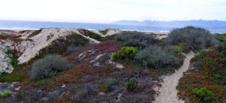
 Pirates Cove/Cave Landing Trail.
Sometimes you hit the perfect trail to end a day. This one was not.
We got this trail out of Robert Stone's Day
Hikes on the California Central Coast
trail guide. The
drive to the trailhead was promising. We took a steep, narrow, paved
road—Cave Landing Road, but short to the parking lot. The book
made it sound promising and our son had talked about it being a good
place to have an evening bonfire. But when we got our of our car,
one of the first things we noticed was that there was litter around
the area. This was a prelude to the trail. The book suggested going
out to the point at Cave Landing first. The view is good—there is
even a sea arch to add visual pleasure. Unfortunately, the whole
area is littered with everything from paper to take-home dinner
containers to condoms. Fortunately, when we moved back to the main
trail and moved down it a ways, the trash problems lessened—or we
got immuned to it. The trail itself is pretty straight with a
downward slope. As you approach the cliff close to the beach, you
can go westward, above the actual sea caves or eastward to a path
leading down to the beach. We took the later path. There are a
series of steps both with wood retainers and steps cut into the
embankment. We walked along the beach for a ways, when we spotted
some folks playing volleyball in a more natural way and we decided
that we would give them their privacy. Distance: .8 miles, 36
minutes, 230' ascent
Pirates Cove/Cave Landing Trail.
Sometimes you hit the perfect trail to end a day. This one was not.
We got this trail out of Robert Stone's Day
Hikes on the California Central Coast
trail guide. The
drive to the trailhead was promising. We took a steep, narrow, paved
road—Cave Landing Road, but short to the parking lot. The book
made it sound promising and our son had talked about it being a good
place to have an evening bonfire. But when we got our of our car,
one of the first things we noticed was that there was litter around
the area. This was a prelude to the trail. The book suggested going
out to the point at Cave Landing first. The view is good—there is
even a sea arch to add visual pleasure. Unfortunately, the whole
area is littered with everything from paper to take-home dinner
containers to condoms. Fortunately, when we moved back to the main
trail and moved down it a ways, the trash problems lessened—or we
got immuned to it. The trail itself is pretty straight with a
downward slope. As you approach the cliff close to the beach, you
can go westward, above the actual sea caves or eastward to a path
leading down to the beach. We took the later path. There are a
series of steps both with wood retainers and steps cut into the
embankment. We walked along the beach for a ways, when we spotted
some folks playing volleyball in a more natural way and we decided
that we would give them their privacy. Distance: .8 miles, 36
minutes, 230' ascent


No comments:
Post a Comment