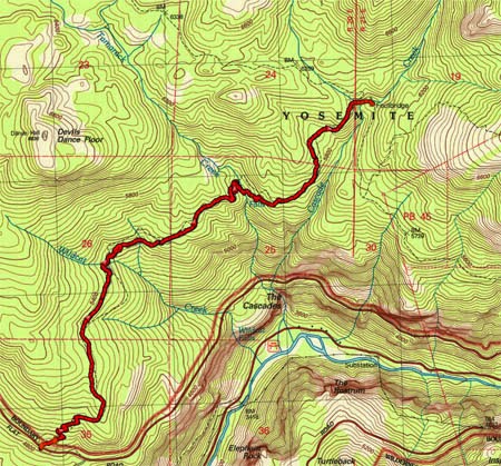
Trail head: Foresta
Hike Info:
Type: /Backpacking
Trail: Parts of Rim Trail
Destination: Cascade Creek
Distance: 4.65 miles
Start Time: 11:31
End Time: 3:46
Travel Time: 4:14 (1.10 mph)
Moving Time: 2:50 (1.64 mph)
Elevation Rise: 1,709'
Maximum Elevation: 6,144'

We started out planning this hike to take people who have not been backpacking before. But things did not work out, so the remaining sojourners are Andrea, Sherri, and myself. But that is good too because we get to spend time with our daughter. The other change in plans was the location. Almost no snow all winter. But last week a couple of feet dumped in the Sierra's-which is a good thing. But our original destination up Alder Creek has more snow than I want to camp in. For years I had been eyeballing a trail out of Foresta. This is not a summer-time trail as there is a lot of exposure to a sun. Even today with it being 90 in Fresno, it will be warm on the first part.
On the way up to meet Andrea, we had an incident. We stopped in Oakhurst to pick up a Subway sandwich, which by the way, we have had good success in stopping here. This time is no different. But when I open up the bear canister to put the sandwiches in, a strong scent of wine, along with a bit of light purple appeared. Our wine bag had sprung a leak. Lots of stuff in the canister was wet and some of it leaked onto my shirt and pack. After using the Subway bathroom to clean up the mess-thanks Subway-we were able to leave. At the entrance station we examined the pack. We just needed to clean up a bit more, but most everything, except for the pack had not been affected. So we are off to meet Andrea.
We got to the trail-head a little after 11, over an hour late. Andrea had gotten here at 9, so she has had a long wait. The first order of business is to repack my backpack after making sure there was nothing affected by the wine flood of 2014. Then we are off, around 11:30.
 |
| Dead Forest |
 |
| Tamarack Falls |
After a mile and a half of this, being under the noon sun, we see the first signs of forests, firs it looked like with some incense cedars. Wildcat Creek is close by. We see the Dance Hall and the Devil's Dance Floor at the end of Wildcat. Now this trail is looking a bit more like a Sierra trail. After crossing Wildcat Creek, we stop for lunch. Not too bad of a place, just enjoying the mountain air to enjoy our Subway sandwiches.
But now it is onward. We have down the major part of our climb so it is more of a relaxed pace. With us being under the trees, the walking is nice, the uphill is moderate, conversation flows freely, but being the afternoon, we are a bit warm. But that changes in a few minutes. Except for the slope of the hillside, you would not realize you are just a quarter-mile above some of the falls of Yosemite-not the famous ones, but the ones Wildcat, Tamarack and Cascade Creeks create.
But this comes to an end-not the conversation or steep hillside, but the warmth. We need to cross Tamarack Creek. As much as we scout around for a place to cross, Andrea only finds a suitable place to cross-without her pack. Sherri and I take off our boots and wade across. That snow-fed creek is COLD! Certainly no thought about how warm the air is. We get dried off and start on our way again. Now it is less than a mile to Cascade Creek. I am a bit concerned about crossing this creek, just because of its size and I think I have read in a blog how this guy had to travel a ways to find a way around it.
But we come to Cascade and find a bridge, and snow. It is getting later in the afternoon. A bit too soon to stop. But looking at the map the next water is four miles away after a pretty good climb. Also this snow is spooking me so I think it is better to camp here. There is a nice spot to stay, with a good fire pit, close to the creek. So camp we do.
After pitching the tent and looking around a bit, we go for a short wander up towards Tamarack Flat along an old road. It turns out this is part of the historic Old Big Oak Flat Road. We do not get very far, maybe a third of a mile when we are stopped once again by Tamarack Creek. With snow all around it, we decide to cross it, but to head a bit towards Cascade Creek on our way down. Just wandering, nothing spectacular.
Dinner is the other half of our Subway sandwich. Andrea brings along split pea soup, which tastes good warm. A fire is started and the evening air turns chilly with the setting of the sun. We wait until we can see stars--well I do not wait, but fall asleep while seated by the fire. But it is nice just being here, enjoying the companionship of wife and daughter.
 |
| Andrea&Gary after Tamarack Creek |
 |
| Tamarack Creek |
 |
| Enjoying the hike |
 |
| Sherri |
 |
| Cascade Creek |
 |
| Wanderings |
 |
| Sherri, Andrea, Gary enjoying the fires |
Hike Info:

Trail: Tamarack Flat Road and wandering
Destination: Cascade Creek
Distance: 1.12 miles
Start Time: 4:46
End Time: 5:39
Travel Time: 0:52 (1.29 mph)
Moving Time: 0:41 (1.64 mph)
Elevation Rise: 265'
Maximum Elevation: 6,261'

1There are several interesting references to this fire. It appears that not only did A-Rock fire burn this area in 1990, but also the Big Meadow controlled burn in 2009. For more references, see the following links:
- Southern California Public Radio
- NPS Big Meadow Fire site
- New York Times article

Tributary 
Falls along tributary
No comments:
Post a Comment