
Title: November 18, 2014 - Trails Around Shaver Lake

Hike Info:
Type: Hiking
Trail: Bear's Highway Trail, near Shaver Lake
Destination: North Fork Stevenson Creek
Actual Destination: Below the Creek
Distance: 2.55 miles 1
Start Time: 9:15
 End Time: 11:22
Travel Time: 2:07 (1.21 mph)
Moving Time: 1:21 (1.89 mph)
Elevation Rise: 833'
Maximum Elevation: 6,785'
1Two things made this longer. The first is the GPS did not sync up and determine an accurate location for about a third of a mile. Second is that from Stevenson Creek, there was about .9 to .95 miles of tracking down a group of hikers which was going the wrong way. I think the actual mileage from the Balsam Snow park to the North Fork of Stevenson Creek was about 2 miles.
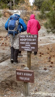 |
| Trail Maintenance Crew |
Another meetup hike. This one being lead by LiAne and a Jerry J. She lives in the area and will be showing us many of the trails she enjoys. But to add to the fun, it looks like we may get some rain today. So we show up at Kohl's at 7 and then are off with a full car load of people. But first our car needs to stop at home to pick up some medicine. We get up to Shaver Lake around 8:40 and meet LiAne there. From there, she takes us to the Balsam Snow Parking area for the first of our hikes. Along the way, these little flying white balls of frozen water start hitting my windshield. But this stuff seems to be more wind driven than falling: outside temperature is 42o.
 |
| Going down the trail |
 |
| Hikers and Scenery |
Then comes the downhill part. Jerry K and I, being in back start muttering that this will be a real bear to go back up. It's steep and neither of us are looking forward to coming back up it. We descend about 600' in a half of mile. But there is some compensation for this: the area is just really good looking. The leaves are all a light tan with some gold and yellow mixed in. The trail itself does wander down, at least not straight down. We do come out into a rock overlook and Shaver Lake spreads out before us.
 |
| Shaver Lake and Tree |
A few minutes later, we cut off the trail and head down a granite slab to the North Fork of Stevenson Creek. When it is warm, there will be a lot of pools to play in. But today, it is cold. Lee F has a probe and measures the water temperature as being 44 degrees-the air is 47. So definitely not a time to jump in.
 |
| North Fork of Stevenson Creek |
After milling around the pools for about 20 minutes. We come back up to the trail junction-where we left the trail. And this is where confusion reigns. We should go right and head back up the dreaded hill. But a group has taken off downward, as if we are heading to Shaver Lake. Lee F, Sherri and I catch up to a group who is wondering about the wisdom of continuing down. But others have leaped ahead of them. A couple of the forward group returns and after a discussion, Lee F and and I take off after the lone errant hiker. We send the rest back to the car.
 |
| Autumn Leaves |
Lee and I wonder if there really is a hiker in front of us or not. But after awhile and looking at marks in the dirt, we decide there really is someone in front of us. Note to Gary: I need to get a lot better at tracking. After a half of a mile, we stop and whistle and shout. A returning call confirms that the hiker is below us. He returns and now for the 800' trudge back up the dreaded hill. I think I am the weak link in the three of us, but we each welcome our brief stops for breath and leg relief.
 |
| Tire along trail |
The last part of the trail runs right below Highway 168. We noticed a Subaru wheel complete with a strut laying 10' off the trail. There must be a story here. When we get to the group, we razz LiAne about the inadequacy of her trail cleanup-they really do a good job. She said she saw the wheel and that it has only been laying around about a week now.
But now on to further adventures.

Hike Info:
Type: Hiking
Trail: Dogwood Trail
Destination: Ely Mountain
Actual Destination: Southern California Edison
Distance: 4.01 miles
Start Time: 11:28
End Time: 3:02
Travel Time: 3:34 (1.13 mph)
Moving Time: 2:11 (1.84 mph)
 Elevation Rise: 585'
Maximum Elevation: 6,912'
Description:Now that we are all at Balsam Snow park, we head across Highway 168 and start walking down a dirt road towards Balsam Forebay. A short time later , there is a fork in the road and we spy the Forebay. Our section of the road veers left around the western part of the Forebay and then to the right before we observe a chain-link fence guarding the Forebay's dam. But being a keen observer, I note, it really is not designed to keep us out as there is a two foot gap under the fence where even I can crawl under.
 |
| Tractor in Buck Brush |
After following the road a ways, we veer off again, onto the Dogwood Trail. Many ducks line this trail and for the most part they are helpful. But this get Say, Jean and I into a discussion on why are ducks called ducks?
 |
| Kaiser Peak in middle; Kerkoff Dome |
But we are getting close to the top of Ely Mountain. I cannot say this is the best view ever. But when we descend a little down from there onto its western flanks, we do get to see Shaver Lake-if it was only full. Right now, it does look like it has a brown bathtub ring. We get to stop and enjoy things for about ten minutes.
 |
| Shaver Lake with bathtub ring |
Now comes a fateful decision. There is a proposal: LiAne will return back the way we came and pick up her vehicle and drive around to the heliport. We will continue on for a short 20 minute walk down to the heliport.At least that is the plan and the start of the fun.
 |
| Are we really going down here? |
This kind of slope is not Sherri's cup of tea, so we were rather slow in picking our way down this. By the time we got down this 700' granite field, we definitely were the last. But this had a bit of advantage. Most people, except for Lee J, Say and Jean had already scampered on and were coming back to say they could not find the trail. They wanted to go back up a ways. At this point, looking down, I thought I could find a route down. So off I went, crashing through the manzanita brush and down the hill side.
 |
| Sherri and Lee on the descent |
 |
| Sherri on the rocks |
LiAne drove us to retrieve our cars and then we all meet at LiAne 's place. She has opened her cabin for this group of sweaty people and prepared a nice after hike meal: chili beans, chipotle mix and minestrone soup. So good! We spend several hours at her place, just enjoying things before we realize we have a drive back. I vote that all after hike meals be held here.
Trail Lesson:
1) Good instructions to hikers helps make everybody know where they are going.
2) When going off-trail or cross-country, keep together. If not possible, split into distinct units.
3) Know where your path leads.
Duck Note:
North American trail marks are sometimes called "ducks" or "duckies", because they sometimes have a "beak" pointing in the direction of the route. The expression "two rocks do not make a duck" reminds hikers that just one rock resting upon another could be the result of accident or nature rather than intentional trail marking. From Wikipedia
The upside of ducks is that they are very easy to construct, and where used you are likely to find many of them. The downside of ducks is that they are very easy to construct and where used you are likely to find many of them. Because so little effort is involved in creating a duck, and because lost people seem to love to make them, they may not provide you the desired level of confidence. In fact, in some areas, they are more like graffiti than trail marker. From HowToWilderness
 |
| Hikers and Autumn Leaves |
 |
| Looking down onto Stevenson Creek |
 |
| Playing around the pools |
 |
| Shaver Lake |
 |
| Say, Jean and Lee J |
 |
| Shaver Lake in Autumn |
No comments:
Post a Comment