 |
| From Wikipedia |
Merced Lake-7,208' (Merced Peak) (37.7382750, -119.4132319)
Merced Pass
Merced Peak
Merced Gorge-2,359' (El Capitan) (37.6763179, -119.7468370)
South Fork of the Merced-1,398, (Kinsley) (37.6538196, -119.8887868)
North Fork of the Merced-932' (Bear Valley)
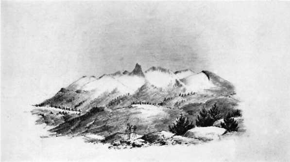 | |
| From Up and Down California by William Brewer | THE OBELISK GROUP (MERCED PEAKS) FROM PORCUPINE FLAT
From a sketch by J. D. Whitney |
| MERCED RIVER, GROVE, LAKE, PEAK (11,722), PASS | [Yosemite, Mount Lyell] |
Merced Grove of big trees was discovered by surveyors for the Coulterville Road in 1871 or 1872 and named by the president of the Turnpike Company, John T. McLean. (Letter from J. T. McLean, 1899.) “In the last two days travelling we have found some trees of the Red-wood species, incredibly large —some of which would measure from 16 to 18 fathom round the trunk at the height of a man’s head from the ground.” (Narrative of the Adventures of Zenas Leonard, Written by Himself, Clearfield, Pa., 1839, reprinted and edited by W. F. Wagner, Cleveland, 1904, p. 180.) Leonard was with Joseph R. Walker’s party crossing the Sierra in 1833. His mention of the big trees is the earliest known and probably applies either to the Merced Grove or to the Tuolumne Grove. (Farquhar: Exploration of the Sierra Nevada, in California Historical Society Quarterly, March, 1925, IV:1, p. 7.)
Merced Lake was called by John Muir “Shadow Lake.” (Scribner’s Monthly, January 1879, p. 416.) “1 first discovered this charming lake in the autumn of 1872, while on my way to the glaciers at the head of the river.” (Muir: The Mountains of California,; 1894, p. 115.)
Merced Peak is also called “Black Mountain” in Whitney’s Yosemite Guide Book, 1870, p. 109. “The last name had, however, been previously given to the highest point of the mass of ridges and peaks at the southern extremity of the range, south of the divide between the San Joaquin and the Merced. All these points, except Gray Peak, have been climbed by the Geological Survey.”
“The range to which it [Mount Clark] belongs is sometimes called the Obelisk Group; but, oftener, the Merced Group, because the branches of that river head around it.” (Whitney: The Yosemite Book, 1868, p. 97.)
“Merced Peak (culminating point of Merced Group).” (Wheeler Survey: Geographical Report, 1889, p. 134.)
Merced Pass was found by Corporal Ottoway while scouting for Lieutenant Denson in 1895 and named by Benson. (H. C. Benson.)
MERCED RIVER, LAKE, PEAK, GORGE, GROVE—The Merced River is the main river in Yosemite National Park, heading on the high peaks of the Sierra Crest and flowing through Yosemite Valley into the San Joaquin River. Merced Lake is located about 13 miles upstream from Yosemite Valley from Happy Isles. Merced Peak is near the southern end of the Clark Range, close to the southern boundary of the Park. The Merced Gorge is the canyon of the river west of Yosemite Valley, while the Merced Grove of Giant Sequoias is the large grove in the southern part of the park.
The name Merced (mercy) is the shortened form of the Spanish name for the river, “El Rio de las Mercedes”, or is sometimes given as “Nuestra Senora de la Merced.” It was named by Gabriel Moraga in 1806.
The Indians called the main branch, “Ahwahnee”. Up to Vernal Fall it was called “Can-o-pah” or “Yan-o-pah”, meaning water cloud. and above Vernal to Nevada Fall, “Yo-wy-we-ack”, the twisting rock branch. The north branch of the Merced, or Tenaya Creek, was called “Py-we-ack” which means “glistening rocks” because of the glacial polish. The south branch, or Illilouette Creek was called “Too-loolo-we-ack” which may have meant “the beautiful.” Yosemite Valley Place Names (1955) by Richard J. Hartesveldt
According to GNIS:
- Merced Gorge
- In Yosemite National Park, extends southwest from Elephant Rock, at mile marker 118 on Merced River to mile marker 114, 2.9 km (1.8 mi) east of El Portal. (US-T121)
- Also called Merced Canyon-Browning, Peter. Yosemite Place Names. Lafayette, California: Great West Books, 1988. p92
- Merced Lake-In Yosemite National Park, on the Merced River at mile marker 140, 1.9 km (1.2 mi) east of Echo Valley and 2.6 km (1.6 mi) north-northeast of Quartzite Peak. (US-T121)
- South Fork of the Merced River
- In Yosemite National Park, heads on the south slope of Merced Peak, flows southwest, west, and northwest to it junction with Merced River, 4.8 km (3 mi) southwest of Trumbull Peak. (US-T121)
- Also called the South Fork of the Merced-Miscellaneous Sources - A brief description and the year of publication (if known) follow: 1871/CA Geological Survey Annual Report
- Also called Illilouette-Miscellaneous Sources - A brief description and the year of publication (if known) follow: 1871/CA Geological Survey Annual Report
- Merced River
- Named by Spanish explorers under Sergeant Gabriel Moraga on September 29, 1806, five days after the feast of Our Lady of Mercey. (US-T121)
- In Yosemite National Park, heads at the junction of Lyell Fork Merced River and Merced Peak Fork, flows west through Lake McClure to the San Joaquin River 45 km (28 mi) west-northwest of Merced. (US-T121)
- Also Called:
- Aux-um-ne
- Aux-um-nes
- Auxumne River: Sanchez, Nellie Van De Grift. Spanish and Indian Place Names of California. San Francisco, California: A.M. Robertson, 1922. p283
- El Rio De Nuestra Senora De La Merced
- El Rio De Nuestra Senora de la Merced: Browning, Peter. Yosemite Place Names. Lafayette, California: Great West Books, 1988. p91
- Noto River: Smith, Jedediah S. The Southwest Expedition of Jedediah S. Smith; His Personal Account of the Journey to California, 1826- 1827. Glendale, California: Arthur H. Clark Company, 1977. p144
- Rio De La Merced
- Rio De Nuestra Senora De La Merced: Smith, Jedediah S. The Southwest Expedition of Jedediah S. Smith; His Personal Account of the Journey to California, 1826- 1827. Glendale, California: Arthur H. Clark Company, 1977. p144
- Rio de la Auxumnes: Browning, Peter. Yosemite Place Names. Lafayette, California: Great West Books, 1988. p91
- Rio de la Merced: Browning, Peter. Yosemite Place Names. Lafayette, California: Great West Books, 1988. p91
- Rio de las Mercedes: The American Guide Series, Compiled and Written by the Federal Writers' Project of the Work Projects Administration. A state by state guide series published by various publishers, in the late 1930's and 1940's. Each book studies and describes each state's history, natural endowments, and special interests. Use code US-T125/Name/YYYY/p#. California/p443
- River of Our Lady of Mercy: The American Guide Series, Compiled and Written by the Federal Writers' Project of the Work Projects Administration. A state by state guide series published by various publishers, in the late 1930's and 1940's. Each book studies and describes each state's history, natural endowments, and special interests. Use code US-T125/Name/YYYY/p#. California/p443
- Wa-kal-la: Gudde, Erwin G. California Place Names: A Geographical Dictionary. Berkeley, California: University of California Press, 1949. p211
Trips:
- May 14, 2014 - Backpack trip to Little Yosemite Valley
- May 15, 2014 - Return trip back to car from Little Yosemite Valley
-
- May 28, 2014 - West Yosemite Valley Loop hike
March 11, 2015 - Hite Cove day hike with Meetup group
April 11, 2015 - Meetup day hike around the East end of the Valley April 15, 2015-Meetup hike from Briceburg to the BLM boundary
October 31, 2015 - Walk around West end of Yosemite Valley with meetup group
November 11, 2015 - Meetup day hike around the East end of the Valley
April 23, 2016 - Meetup hike around the east end of the valley
April 30, 2016 - Meetup hike around the west end of Yosemite Valley
- August 8, 2016 - Start of our JMT attempt with Rose
- October 1, 2016 - Meetup hike around the west end of Yosemite Valley
- November 17, 2017 - Day hike with Sherri and Gary, exploring where the Wawona Arboretum is
- March 27, 2018-Walking west of Briceburg with Sherri, Steven and Gary
- March 28, 2018 - Yosemite Valley Wander by myself.
- March 9, 2019 - Meetup hike from Briceburg to the Sierra NF boundary and back
- March 23, 2019 - Meetup hike from Briceburg going west towards Railroad Flat in the rain.
- November 10, 2019 - Day hike on the Valley Loop Trail with Steven, Andrea, Sherri and Gary
- March 24, 2021 - Walked Incline Road with Betty, Rose, Sherri and Gary
- April 16, 2021 - Walked from Railroad Flat to the North Fork of the Merced-Andrea, Lawrence, Sherri, Korra, and Gary
- May 5, 2021 - Walking the middle portion of Yosemite Valley on the Valley Loop Trail with Rose, Sherri and Gary
- November 2, 2021 - Day hike around the central part of Yosemite Valley
- January 6, 2021 - Afternoon trip to the Valley in the snow. Walked around Leidig Meadow. Spectacular in the snow
- April 28, 2022 - Stroll along the east end of Yosemite, a lot of it along the Merced.
- May 10, 2023 - Same stroll as on April 28, 2022. We walk this with Jessi, Sherri and Gary
- May 23, 2023 - Exploring Yosemite Valley, tourist style, with Connie, Steve, Sherri and Gary
- November 6, 2024 - Walking around the east end of the Valley from Camp Curry to Mirror Lake and over to the Ahwahnee
- November 13, 2024 - Sherri and Gary walked the west side of the Valley from Bridalveil up to the base of El Capitan, down to the Pohono Bridge and back.
References:
Pictures:


 |
| South Fork Drainage near Merced Peak |

 |
| South Fork |
 |
| South Fork |
 |
| Around Briceburg |
 |
| Around Briceburg |
 |
| Around Briceburg |


 |
| May 10, 2023 - From Happy Isles bridge |
 |
| May 10, 2023 -From a trail along the Merced |
 |
| May 10, 2023 -From Valley View |
No comments:
Post a Comment