Hike Info : Description : Extra Photo's : Animals : Flowers and Plants

Type: Hiking
Trail head: Potwisha
Trail: Potwisha Flume
Destination: Unknown
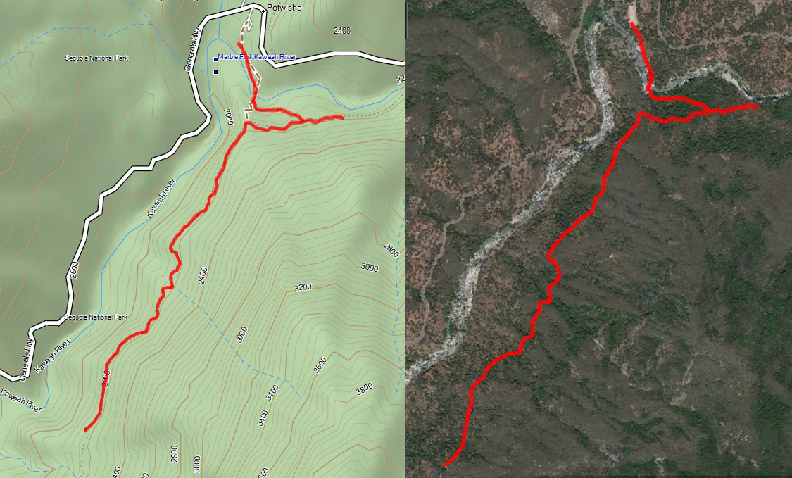
Actual Destination: About 1.25 miles west on the flume
Distance: 3.61 miles
Start Time: 11:04
End Time: 2:26
Travel Time: 3:22 (1.07 mph)
Moving Time: 2:23 (1.51 mph)
Elevation Rise: 966 ' 640
Descent: 954‘ 645
Maximum Elevation: 2,198'
 |
| Bridge across the Kaweah |
Last year Betty and I walked the Potwisha Flume on the south side of the Kaweah. Since that time, the KNP Complex fire swept through the area, ravaging anything which stood in its way. Talking to several people, they indicate that the flume has been damaged, but is still walkable. I am interested in seeing how the area now looks. Fearing the worst that the area will be devoid of trees and hoping that only patches have been damaged.
Betty will meet up at the Potwisha area around 11. We leave right at 9. This is Sherri’s second hike . after her surgery, we will be determining how far we go based upon what she can deal with-not wanting to get too close to the edge like last week. Last week she did well on a trail which proved more than anticipated. Today’s should not be as hard. Sherri and I drive straight to the park. We forgot this was Spring Break, so we were surprised by a couple things: first the line at the SEKI entry station. Second, looking in the mirror, Betty is right behind us. We got to the parking lot a little bit early, about 10:40 and got ready to go. Before we go, we help a father-son who was wondering what trails there are around here.

Spot burn from the KNP Fire
The first part of the trail
leads us to the bridge across the Kaweah. This is probably the worst
part of the whole trail. Lots of river rock in the couple hundred
yards.In the midst of the rock, there are Indian grinding holes.
Also some person thought that by writing graffiti on the rocks in the
area, he is improving the looks of the trail-hardly. The bridge
across is a modified suspension bridge. It swings, sways and bounces
as we walk across it. Once we cross it, the trick is to find the way
over or around the rock-Hint: around the rock on the east. Betty has
to remind me of this.
 |
| Gary walking the flume path |
 |
| As far east as we will go |
When we look into the flume, we think that the measurement of water flow will be superfluous for a while. Not only is there no water in the flume, but a layer of mud at least two inches thick lays at the bottom. We follow the flume towards the east. The going is pretty easy for a short way. And then we see where the fire has damaged a walkway. There is a long walkway, or there was. About 20’ of it is no longer there. I guess we could have climbed up, but there is caution tape warning us away.

The flume as a fire break
This is our trigger to turn around and head west. For the most part, this is a pretty nice walk. Mostly level. We can see where the firefighters have used the flume as a fire break. Most of the fire is on the other side of the flume, the south side. But this has its own issues. That is the uphill side. Whenever we come across a ravine, we see that sand and silt have swept over the edge of the flume, filling it. I would hate to be the person with the shovel scoping out all of this debris.
 |
| Damage to the flume |
After walking a mile and a half, we stop for lunch. The silt has made a nice seat for me. Sherri decides to sit on the ground while Betty also sits on top of the flume-on the other side of a pillar. After a break of 15 minutes, we continue on.. I do not think we will reach the pool at the end of the trail-we have started too late. But we enjoy ourselves in the sun, but not too hot of one. We are able to see the SEKI’s headquarter at Ash Mountain and then beyond to Three Rivers. Across the way are hillsides fully burnt. So sad. And then we look to the snow capped peaks to the east which brings a bit of joy to our hearts.

Lunch Time 
Sherri and Betty walking the flume
Like when we went east, our
trail came to a sudden end. Part of the flume has washed out, taking
out the trail. I think we could have climbed into the flume and
walked further, but we have gone as far to make us satisfied with our
walk. So we will save the rest for the next time.
 |
| End of our walk |
The return trip is pretty much uneventful. I am trailing behind, not because I am tired-surprisingly, but there seems to be alot to stop, examine and take pictures of. Besides, Sherri and Betty look like they do not need me very much. They are moving on nicely. That is until we get to a ravine when I catch up. I go down first, as it turns out more for moral support. After this, it is a short walk to the flow monitor. And then down the trail. It is a bit steep, but not bad-just looks a bit unnerving at first glance.

Real ashes on Ash Mountain 
Flume and Moro Rock
We cross the bridge and then
go the short walk back to the cars. Everything looks good there.
After resting for a few minutes and getting our boots off, we are
ready to go. Betty mentions that she will stop at Reimers
in Three
Rivers. As we drive on, Sherri decides this would be a good stopping
place for ice cream. Then it is off to Fresno. We get in a little
before 5pm. After driving about 4 hours, I am beat, but feel pretty
good. Glad we did this walk.
I began this blog with the fear of complete devastation. But my hope won out as there are definitely places where the KNP Complex Fire burnt and damaged both the flume and the trail. But it is still very walkable and enjoyable.

 |
| Sherri traversing a ravine where the flume broke |
 |
| Trail crosses a plank |
 |
| The Flume Girls-Betty and Sherri |
 |
| Wall flowers?? Baby Blue-eyes along the flume |
 |
| Gary looking out on the Kaweah River |
 |
| Indian Grinding Holes |
 |
| Kaweah River |
 |
| Toys left to play with-NOT! Clean up tools |
 |
| Gary walking the flume |
 |
| Betty and the flume |
 |
| Betty and Sherri beside the flume |
 |
| Sherri and Betty walking the plank |
 |
| Possibly a red fox-thanks Rose |

 |
| Sierra Lizard |
Flowers and Plants
 |
| Common Madea |
 |
| Common Madea |
 |
| Golden Brodiaea, Pretty Face |
 |
| Baby Blue-Eyes |
 |
| Baby Blue-Eyes |
 |
| Baby Blue-Eyes |
 |
| Baby Blue-Eyes |
 |
| Miner's Lettuce |
 |
| Sierra Arnica |
 |
| California Indian Pink |
 |
| California Indian Pink |
 |
| Chinese Houses |
| California Indian Pink |
 |
| Fireweed |
 |
| Fireweed |
 |
| Fireweed |
 |
| Western Wallflower |