

Title: April 7, 2021 - Potwisha Flume
Hike Info : Description : Background : Extra Photo's : Animals : Flowers and Plants

Trail: Flume on South Side of the Kaweah
Destination: End of the Flume
Actual Destination: About half a mile before the end
Distance: 7.36 miles
Start Time: 9:05
End Time: 2:59
Travel Time: 5:53 (1.23 mph)
Moving Time: 4:15 (1.71 mph)
Elevation Rise: 1,687' 1
Descent: 1,687‘1
Maximum Elevation: 2,200'
 |
| Grinding Holes |
 |
| Bridge over the Kaweah |
Don, a friend in my neighborhood, told me a couple of weeks ago about a flume close to Potwisha on the Kaweah River. He was going to hike it soon. That piqued my interest. So before it got too hot, I thought we would hike it today. I found a trail report on it and saw it on Google Earth. Our regular group dropped out on me, except for Betty. I made arrangements to meet Betty in Farmersville at 8:15. Then off to Potwisha which we made a little before 9. A good thing we started earlier than later since there are some exposed places on the southwest side of the flume which started to get a bit hot.
 |
| Locked Ladder |
Betty and my boots hit the ground just a few minutes after 9. Betty is telling me that she has gone for a hike from this trailhead-over to Hospital Rock. But we will be crossing the Kaweah. But first we come to a large rock where we see some Indian grinding holes. After navigating through some river stones, we come to a bridge across the Kaweah. From what I can tell, this was made more for servicing the flume than for us hikers. But there is no reason why we cannot use it. There is a bit of sway which I was not expecting.
 |
| Planks to walk on |
But we miss the pictograph and
head up the trail. Lots of little flowers-mostly from the Miner’s
Lettuce. We also see a little Sierra Newt. When we get to the top,
there is the flume and a tower. The tower I think is a gauging
station as there is a pipe coming out of the flume and a strip having
markings indicating water level. We are wondering if it is in depth
or flow or what? Whatever it is measuring, there is only a couple
inches of water flowing. I am thinking in a couple of weeks, there
may not be any water. (Doing some reading apparently what we saw is
called a
Parshall Flume-used
to gauge the flow of liquid.)
Gauging Station
Of the two ways we can go, we
decide to go east towards where the water enters the flume. The path
is pretty level with only a few ups and downs and nothing more than a
few feet. The places where there is a major dip, boards have been
placed to level the trail. It is my opportunity to walk the plank.
When we hit the end of the path, there is no place to go, even though we are not quite at the place where water enters the flume. There are boards across the rest of the flume and the ladder up to it has been locked. Can we go down and around? Maybe, but for this old body, I am not as anxious to see the end. So Betty and I look at each other and retreat, only just a little disappointed. (Talking with my friend Don, he indicated he and his friend scampered down and around. Did not say if there was much of interest.)


And now we come back to the gauging station/monument. We go past this and it is more of the same. We enjoy the quietness of being alone, even though we are a short distance from anybody else. The sound of the river masks the signs of civilization, except for a few loud cars. But even these pass quickly. But as we pass westward, the trees overhead are replaced with more frequency by lower brush. And the brush opens up to grasses. This lets in more sunlight. Pleasant now, but what will it be this afternoon?

Truck and Bovine
On one of our stop and gawk
places we spy what looks like the path of our flume. But why is it
higher up than us? Can water in this part of the world flow
magically uphill? After all, this place seems to intersect another
world at times.. Also at what looks like an end, there is a truck
sitting up there. Is there a road going there? And why is the truck
there in the first place? There is a large white object just below
the truck. I think it is a goat; Betty thinks it is a rock. (When I
get home, I enlarge a grainy photo and it is of bovine nature-where
is Sherri when there is a cow around?)

A little ways further we stop under a tree-now not nearly as plentiful for lunch. Pleasant just resting here. The body and the mind are saying, “Do I really want to go on?” Of course I do! Also Betty does too. So we will continue on a ways, hopefully making it up to where the truck is.
 |
| Planks by flume outlet |
A short ways further, we hear the sound of rushing water. Sounds like a pretty decent size creek. The path dips down a ways, followed by more planks. It looks like the water is being released from the flume. This is the longest set of planks and it is playing some minor mind tricks on this fear-of-heights person. But we make it across without a problem.

Distance from start of flume
When we get back level to the
flume, we look in and there are only puddles of water in the flume.
Where did that thin layer of water go? Of course! It is being
released, creating the creek we just crossed. Also I notice that we
are now going uphill., not in a major way, but enough that careful observation will notice. This is an Ah Ha! moment. Remember we had
seen something which looked like it was going uphill? Now we know
what we were seeing is the flume. (When we get home, I look at Google
Earth-there is a pond at the upper end of the trail.)
I do not think we will be making it to the end, but at least we can get close by getting around two ridges. We do that. While we want to go on, we also think it is prudent to turn around and leave the rest of the flume for another time.
 |
| Moro Rock |
 |
| Redbud Reflection |
We pass by the people on the bridge quickly-my thoughts are, don’t these people realize there is still a pandemic going on? We get by rather fast. And then it is a short hike back to the car. We get back an hour later than I expected-this is getting habit forming. It has been a good hike. I think I would do it again, either late Winter or early Spring. We take off in separate cars. I get back to Fresno by about 5pm, plenty of time to shower, eat, and have our family Zoom call.

Some References:
CaliSphere - pictures of where a gauging station is
Picryl - Picture of the intake into the flume
SEKI - old pictures of the area and flume
The flume was built by the Mt Whitney Power Company which was sold to Huntington which was bought by Southern California Edison.
Extra Photo's
 |
| Betty looking at the stonework |
 |
| Redbud and the Kaweah River |
 |
| Kaweah River |
 |
| Kaweah River |
 |
| Looking towards Three Rivers |
 |
| Trough to carry creek water over flume |
 |
| Ash Mountain-Park Headquarters |
 |
| Looking east. Also note the flume's path on ridge |
 |
| Dry Flume |
 |
| Path by flume |
 |
| Flume |
Animals
 |
| Possible bobcat scat |
 |
| Arboreal Salamander |
 |
| California Newt |
Flowers and Plants
 |
| Miner's Lettuce |
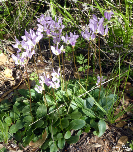 |
| Shooting Star |
 |
| Fiddleneck |
 |
| Whiteleaf Manzanita |
 |
| Golden Yarrow? |
No comments:
Post a Comment