Showing posts with label Crane Flat. Show all posts

Thursday, October 15, 2020

October 15, 2020 - Merced Grove


Title: October 15, 2020 - Merced Grove
Hike Info : Description : Extra Photo's 

Hike Info:
Type: Hiking 
Trail: Merced Grove Trail
Destination: Merced Grove
Actual Destination: a little beyond>
Distance: 4.33 miles
Start Time: 12:49
End Time: 4:07
Travel Time: 3:18 (1.31 mph)
Moving Time: 2:40 (1.62 mph)
Elevation Rise: 642'
Descent: 457‘
Maximum Elevation: 5,903'

GPS Tracks

Description:

I got up a bit later than usual, about 7am. Sherri gets going after I do. But we are pretty pathetic in getting a good start-about 9:45. We had checked the webcams for Yosemite Valley and they were not encouraging. The air quality sensors were even less so. But we have a Yosemite Park pass for a week, so we should use it. This is day number two.


We knew there was smoke towards
Yosemite. The Creek Fire has been puffing along for a month and a half now. Even once we got by the San Joaquin River, there was nothing but smokey skies. I start looking up alternatives to Wawona/Mariposa Grove as that way looks pretty bad-by the way, Sherri is driving. When we top the pass leading into Oakhurst, we see nothing but smoke. Going into Wawona, it is confirmed. We will try the Valley. But the incoming smoke yesterday does not sound too promising. At Chinquapin, we change drivers.

Yosemite Valley is pretty smokey, not as bad as Wawona. We do stop for pictures of the smoke. Sherri wants to see Sequoia trees, which are worth a trip anytime. She talks about Tuolumne Grove. But in my looking around while she is driving, I came across Merced Grove, a place she and I have not been too before. So we decide this is a good destination-Sequoias and a new destination.

Study in an Autumn light

Merced Grove is beyond the Crane Flat cut off, towards the Big Oak Flat cutoff. When we get to the parking lot, we stop and have lunch. Only a couple of cars are in the lot.

The write up both on Redwood Hikes and on the board at the start of the trail says that this is a small grove. Only about 20 trees or so. The sign talks a little bit about the background of the area.

The trail starts out on a dirt road. When I got home, I saw on Google Maps that this is the remnants of the Old Yosemite-Coulterville Road. We travel about half of a mile on the road. Looks like there has been a major fire on the west side of the road-very probably the Rim Fire. We get to a junction where we take the left road down-this is where we depart from the Old Yosemite-Coulterville Road.

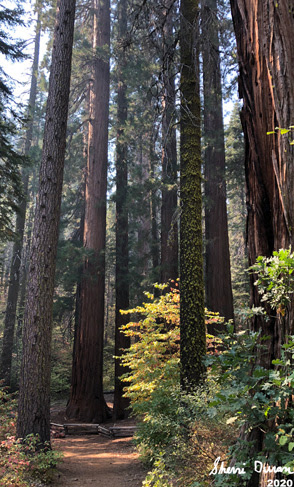
Trail through the Sequoias

The trail down to the grove is on a less maintained road, which is gated at the top. Note the word down as parts of it goes down pretty steeply. But the fall colors are starting to pop-out on some of the broadleaf trees. A pleasant warm afternoon walk down.

There are five Sequoias which mark the entrance to the Grove. These are not the massive trees found in Mariposa Grove or at Giant Forest. But there is a certain majesty reflecting their Creator which strikes you. Also unlike other groves, we are seemingly alone here to enjoy, contemplate and reflect the glory of this world. We stop and rest for a few minutes before going further into the grove.

About a hundred feet further down, a Sequoia grows into the trail. Or should I say the trail has gotten too close to the tree. Either way, we are up close and personal with the tree. A little ways further is the old Yosemite Superintendent’s vacation cabin. This would make it worthwhile going through the heartache of being Superintendent. Now it is used as an educational place for when school children visit the grove.

Us waiting by the cabin


We meet up with the sole other human presence-a husband waiting for his wife, unmasked. We go and sit on the steps of the cabin and wait for them to do their thing. Their squabbling is a jarring contrast to the serenity otherwise experienced in this place of peace.


Standing in Awe

We continue on past the cabin and come to the grove. I have counted 23 Sequoias and wonder if there are others bashful and in hiding. We comment that this would be such a good place to spend overnight and wondering about backpacking in. Maybe during the Spring when the creeks have water in them.

The trail starts to slope down again, so we decide to turn back. We pass through the grove on our return, pausing a few times, not from exertion, but to take in the majestic standing organisms which bring awe to our eyes. If we are in awe of them, how will we be before that which created them?

After passing through the grove, we start on our upward climb, back to the top of the road. But now stopping due to exertion, rather than in awe, even though the arboreal overhang is worth stopping for anyplace else on earth, except in the sight of the Sequoias.

When we reach the trail junction, we wonder where the other road segment goes to. I think it might be some sort of facility, but I am wrong. It is pretty flat and after about a third of a mile, we hit a triangalish junction. We decide that is enough for today. But we do wonder what adventures those roads would lead us to? We find out later that the one on the right, west, would eventually take us down to Coulterville. I wonder, would the stagecoach riders have been in awe of what they were seeing? Or are they like us when we pass by in our cars?

Towering Trees


We head back the way we came. About a hundred yards from the cars, just a curve away from the parking lot, we meet three people walking. Two put on masks, one does not. They ask, how far is it to the grove? I do not know what is going through Sherri’s mind, but in my mind, this is a question which people ask which either have no idea of distances or are in danger of not making it. We answer about a mile and a quarter with a 500’ descent. They do not seem to be too interested in that much effort. They just want to see some Sequoias without the time and energy to appreciate them. We give them some other suggestions-Tuolumne Grove or up in Calaveras Big Trees. And then we speed off back to the car-sort of a funny term for me these days, “speeding of”.

To go back to Fresno, we head down Highway 120 towards Sonora. But instead of going to Sonora, we take a route through Groveland to Coulterville, a route we have not done in 40 years. Once in Coulterville, we go and enjoy the drive down 49 until we get to Mariposa. By now, we are hungry and grab dinner at Burger Kings. For some reason, it tastes pretty good-not gourmet, but it hits the spot. Then it is our normal drive down to Fresno. What a good day!


Extra Photo's

Shadow Hikers


Towering Trees


Superintendent's Cabin

Superintendent's Cabin

Gary trying to capture a tree

Sherri's Selfie

Sherri and a Sequoia


Five Sequoias at the Enterance

Sequoias


Tall Trees

Autumn Light

Start of Trail


Saturday, October 14, 2017

October 14, 2017 - Crane Flat Lookout and Tuolumne Grove


Title: October 14, 2017 - Crane Flat Lookout and Tuolumne Grove
Hike Info : Description :   Extra Photo's : Animals : Flowers and Plants


Trail head: Tuolumne Grove Parking Lot
Hike Info:
Type: Hiking
Trail: Crane Flat Lookout, Tuolumne Grove
Destination:  Crane Flat Lookout, Tuolumne Grove
Distance:  5.56 miles
Start Time:  11:46
End Time:     4:34
Travel Time:  4:48 (1.16 mph)
Moving Time:  4:41  (1.19 mph)
Elevation Rise:  1,343'
Maximum Elevation: 6,658'
GPS Tracks


Description:
This started out with as a trip with Rose and Sonya. But as the date got closer, one by one they acquired other obligations. In the meantime, we had invited our friend Carol to walk with us as well. So today, it is Carol, Sherri and I in Yosemite. Carol comes by at 7:30 and we get off by 7:45. This is my first time up in Yosemite since June. Exciting.
El Cap Rockfall
El Cap Rockfall
It got even more exciting as we got closer to the Valley. As we come through Tunnel View, we should be seeing the grandeur of Yosemite Valley, Half Dome standing at the far end with El Capitan guarding the gate. But what do we see and taste? Smoke. Cannot see Half Dome and Bridalveil and El Cap is barely viewable.  We decide to drive through the Valley and see what we can see. If things improve great, otherwise, we will stop and see the recent rockfall from El Capitan. Then go on up to Tuolumne Grove. Hopefully there is less smoke there.


Empire Fire
The gash left by the rockfall in El Capitan is impressive. Just huge. Anyplace else, it would be an attraction itself. But with El Capitan, it is somewhat like losing a couple hairs off of one's head. Once the new rock exposed ages a winter, it will be hard to see where the rockfall was.
Carol and Tree


One up to Tuolumne Grove. Sherri spots smoke from the Empire Fire. So we  stopped to look and take pictures. When we get to Tuolumne Grove, the parking lot is pretty close to full-but we find a place. Wonder what it looks like on a Summer’s Saturday.
Our first stop, that is after the bathrooms, is Crane Flat Lookout. We head off in the opposite direction as everybody else-westward. There is an old road which we follow until the trail veers off and goes up a hill. No amazing views or anything, just good Sierra dirt underfoot.
Black Bear
About halfway up you hit the paved road to the Crane Flat Heliport. A few steps up up, Carol whispers”Bear”. Sure enough, there is a black blob maybe about 30 yards away. Not too close, but close enough. The bear is just peacefully rummaging around at the base of a tree for some food-bugs and stuff. We take our pictures, trying not to disturb. I then cross the road opposite of the bear and this perks its attention, but does not move. I continue around on the far side of the road, hoping to catch him at a different angle. This spooks the bear and it runs off, not to be seen again, as much as I am on the lookout for it.


Sugar Pine Cone


So off we go. The rest of the way is paved, but with little traffic as the only destination is the heliport and the lookout. We meet nobody. The road is uphill, but not steep. You only get tired of walking on the pavement for the mile and half or so. But there are some splendid sugar pines along the way.

Osborne Fire Finder


Once we reach the helipad, we walk across the parking area to the continuation of the trail. (I think that NPS would prefer you not going straight over because sometimes there are vehicles can come through pretty fast in emergency situations. Last time we were here, we were talking with a pilot and we just followed her and her co-pilot over to the lookout.) So we go around the parking area and hit the lookout from the far side.
Empire Fire
The lookout is of the “rustic” Park Service style. Henness Ridge also is this style. We go up into the tower-it is only two stories and look around. They have an Osborne Firefinder, but it is off of true by about 17 degrees. Maybe it was trued with a compass, rather than true north. We look around and there is a few remnants of its glory in the cab. We also see the Empire Fire continuing to smoke, with a smaller column to the west.Due west of us is Pilot Lookout.  After spending about half an hour up here, we go down for lunch at a picnic table at the lookout’s base. After hearing a noise going on and off, we realize it is the fan on a shipping container holding communication equipment.
Pilot Lookout
Mountains to East of Lookout


Carol and Gary


Now it is time to go back down to the car. we scaddle on down the trail and then the road the way we came up. More stopping to admire the sugar pine cones. It is a lot easier going down to the car than going UP to the lookout. Maybe it is because I am still having some minor effects from this summer. Whatever it is, we make it down to the car pretty well. Well enough that Sherri asks Carol about visiting Tuolumne Grove-she does not ask me.

Carol and Sherri

Since the answer was yes, off we go. The thing which I do not like about this trail is that it is downhill. You might be asking, what is wrong with that? Like Isaac Newton would have said if he was a hiker: whatever goes down, must come back up. But down we go.

Dogwood Berry


There are some subtle differences in the environment from Crane Flat, even though it is the same starting place. The most prominent is that the dogwood are bursting out with a new wardrobe. Instead of green and white, it is red and yellow with some orangish ornaments called berries. We stop every once in awhile to examine a tree or berries. This is definitely not a hike for the record books, but for the eye candy.


Carol peeking around a dogwood
The trail is an old paved road-I sort of remember going down this in a car once when my family came to Yosemite. It gets a bit steep. Also there is a bit of a culture shock from going to Crane Flat-lots more people with the accompanying noise and distractions of rowdiness. Don’t get me wrong, for the most part, people were orderly and following the procedures. But most is the operative word here.
Still the area is pleasant enough. We go on a loop into the Grove, enjoying the scenery. Sort of like a Japanese garden in flavor, but not stature-these are Sequoias after all. A brook goes through the middle of the loop, giving even more of that oriental flavor. Lots of pictures of the dogwoods and their berries. We went through a tunnel tree, but did not get any pictures of us-too many people.
My rest deer
Back to the start of the loop and working our way up. Seemed like a pretty good descent going in. Even more so going out. First really good climb since the summer stuff. A deer is off the side of the road, so it is worthwhile stopping to enjoy her.  But we make it up, going one step in front of the other. Finally making it up to the car by 4:30. Tired but good.


Yosemite Valley
We stopped at Tunnel View-I wanted a picture of the smokey Valley. But was disappointed-it had cleared up magnificently with just enough smoke to catch the evening rays, turning everything a rosy color. When we passed through Oakhurst, stopped at Sugar Pine Pizza-actually called from Wawona. They had the pizza all ready for us, piping hot. After filling ourselves, we go on down to Fresno. We say by to Carol and then jump in the showers. A good day. Not lots of miles, but still an enjoyable one.


Extra Photo's
El Capitan Rockfall
Helicopter at Crane Flat Heliport

Gary and Carol
Rockfall scar on El Capitan

Another view of the scar, plus Clouds Rest and Half Dome

Three Brothers and Bridalveil Falls

Three Brothers and Bridalveil Falls


Animals

Another Bear View

Lizard trying to be unnoticable

Crow

Deer in hiding


Flowers and Plants
Dogwood Berries

Dogwood Leaves in Autumn

Dogwood Berries

Dogwood Leaves in Autumn
Sugar Pine Cone