Showing posts with label Kings Canyon. Show all posts

Friday, October 25, 2024

October 25. 2024 - Giant Forest


Title: October 25. 2024 - Giant Forest

Hike Info : Description : Background : Extra Photo's : Flowers and Plants
Hike Info:

Type: Hiking 

Trail head: Giant Forest Museum parking area

Trail:  Moro Rock, Soldier, Bill Hill Trails

Destination: Lop

Distance:  4.27 miles 

Start Time: 11:48

End Time:    3:42


Travel Time:  3:54 (1.10 mph)

Moving Time:  2;49  (1.52 mph)

Elevation Rise:  1,122'

Descent: 828‘

Maximum Elevation: 6,800'

GPS Tracks


Description:

Happy Birthday to Me! I got up at 5:30. Then I lumbered around for a while, then had breakfast. Sherri gets up at 7:45. Yesterday we got a letter saying that Liberty Mutual is dropping our home insurance. Why? Some outbuilding have either algae, mold, or mildew. I go up to make sure I do not find any of that-I do not. Then phone up Liberty and ordered a copy of the image they are using to make this determination. Guess we will see how this all turns out.

We leave our home at 9:30. Because it is my birthday, Sherri decides to drive. So I settled back and enjoyed the ride. We briefly stop when we get into the Park. Then on to Giant Forest. We arrived about 11:40. As we were getting ready, a man from Kyrgyzstan asked to have his picture taken. First time I have met someone from there. Then a couple from Toronto parked beside us. They asked where would be a good place to go around here/ I recommended Crescent Meadows, then the General Sherman tree. Both are really awesome.


About noon, we are ready to start. That is after using the restroom. Sherri needs to go back and change out her glasses, so I sit on a log and wait. The route which we are going to do today, we have done a couple of times before. This is our Fall hike in the area. I think we are about a week, maybe two early.While there are Fall colors, there is still much green showing.

The first part of our walk is the Moro Rock Trail. This takes us through a forest of burnt trees. I speculate this was caused by the KNP Complex Fire, about three years ago. The burnt forest is there with a backdrop of smoke. I think this smoke is from the Happy Fire, north of Kings Canyon.

As we progress along the trail, we leave the burnt forest behind and go through a couple ravines. We now encounter some of the colors we were hoping for. Mostly the yellowing of ferns with a few touches of red of the dogwoods. Of course, there is the reddish-orange of the bark of my Sequoias. And I say “my” Sequoias. Who really owns them but Him who created them. I am only able to appreciate and love that Creator through enjoying these trees.


Soldier Trail
Along this route I think of another time along here. John and Cathy come to mind by a particular Sequoia. A spot along the trail where Rose and I lightly discussed some of the current topics of our time. It was good to be able to share a trail, a place, a time with others. It is even better being able to share this time with my wife.

We get to the road to Moro Rock and this ends our time on the Moro Rock trail. We walked along the Crescent Meadow Road for a third of a mile, at the Buttress Tree, I took a picture for some Japanese youth-are almost all people younger than me now? Then we reach a favorite trail in the Park, the Soldier Trail-take a look below for why it is called that. We seldom find people on it. And I will not advertise it too much.

A couple hundred feet onto Soldiers Trail, we find a nice rock to sit on and have lunch. Maybe we did not go far enough. Most of what we see is a sea of green, red and yellow. This is why we came this way. But looking a bit to the east I see the glint of a reflection from cars going around the Tunnel Log Tree. But we do not hear them, instead we are able to enjoy a lunch in comparative isolation.

After lunch we continue our climb up and over an unnamed ridge which Bear Hill is on. This takes us out of the area of Fall colors and into an area which had fire a while back. There is one burnt tree which I have been fascinated with called the Burnt Arrow.

When we reach the top of the ridge, we go downhill rather steeply. It is surprising to me how much down we are going as it does not seem like we have gone up all that much. Sherri and I have a discussion about the steepness. I think the Lewis Creek trail in parts is steep; Sherri thinks this is steeper. When I lay down the tracks after we get home, I find out the Soldier Trail has a steeper down hill. I learn something new.

Burnt Arrow
At the bottom of the ridge, we come across a couple of trail junctions. One will lead us back up the ridge, another down to the highway and Round Meadow. But we chose the way to Bear Hill.

This gets us onto an uphill stretch, which seems more uphill than the 120’ it is. It is still one foot in front of the other. We get to the junction of the trail going to the Museum. But we travel a hundred feet further and come to Bear Hill. How do we know? A sign says so. Also there is a RAWS here as well-looks like a large, menacing robot. In the robot’s presence, we rest for a few minutes and greedily gulp down Sherri’s peanut butter cookie.

I had seen that a second trail leads down to the Museum area. This one being 0.5 miles. We decided to take this trail rather than the normal one. Why? Not because it is shorter, but because I could not remember going down it before. That is always a good reason for me to go down a trail.


This one did not disappoint either. It is completely one way-down. There is one place where we get on an overlook to the southwest which has the haze on it. We started off in a strictly pine forest. But then it gives way for a final display of color before emptying us out on the Crescent Meadows Road, a little ways from the Museum.

Even this did not disappoint on the excitement front. The road is narrow and even normally two cars facing each other would have to wait. And now you have two hikers also on the side. But the cars sorted things out and we walked down to the Museum, then across the General’s highway to our waiting car. We got back about 3:40.

It takes about 20 minutes for us and then we are off. Sherri offers to drive, but I could tell, she was not really into it. So I drove back. The discussion we have is do we stop at Bear Mountain Pizza or eat at home leftover chicken marsala and garlic potatoes which Steven made yesterday for my birthday? What kind of fool would turn down the chicken marsala, so that is what we did when we got back at 5:50. This is my kind of birthday

.


Background

Giant Forest RAWS station at Bear Hill
Soldiers Trail. I recently found out why this was called the Soldier’s Trail. Just beyond that, you’ll pass the site of Soldiers Camp, from which this trail derives its name. On this site in 1911, the army set up a camp from which they patrolled the forest to protect the Sequoias. Since most visitors at the time camped near Round Meadow, the army was frequently passing between the camp and what is now the Giant Forest Museum. At first, the soldiers followed the road, but they soon cut their own trail, shaving nearly a mile off of the route. This trail is the one you’ve been following since leaving the Alta Trail. From Modern Hiker blog.

RAWS. RAWS stands for Remote Automatic Weather Stations. This particular station is known as Giant Forest and can be found through Mesowest.


Extra Photo's


Gary and a Sequoia

Dogwood

Red leaves of fall


Deer Ridge


Gary

Fall Leaves

Fall Leaves

Scene off of Soldier Trail

More fall foilage

Top of ridge on Soldier Trail

Sky watching


Flowers and Plants


Dogwood

Dogwood pods

Dogwood

Dogwood pods

Fungi

Wednesday, July 24, 2024

July 24, 2024 - Park Ridge Lookout


Title:  July 24, 2024 - Park Ridge Lookout
Hike Info : Description : Animals 
Hike Info:
Type: Lookout

Description:

I got up a little after 0600 and got ready to go to Park Ridge Lookout. I already did the lightning report last night and today might be exciting in our area with all of the strikes. I get off a little before 0700. As I passed by Centerville, I realized that I forgot the string cheese-only a minor inconvenience. At Yokut/Squaw Valley, there is construction going on-a known quantity-and so I am delayed another 15 minutes. I zoomed through the Park’s entrance station-after all I am sort of like a Park person, not quite, but close enough. Then up the Panoramic Point Road to the Park Ridge Service Road. Then another 20 minutes and I am at the lookout. Not a lot to unload after all I am here for only a day. There is even less than anticipated-I forgot my lunch and snack food. In my day pack there are a couple energy bars and some Life Savers to keep me from dying from hunger, as if my body fat would let me down.

The cab is hot, but starts cooling down once I open the windows and the door. I suppose that is the reason why we do not live in glass houses with a tin roof. I take the weather and go in-service by 0930. I talked with Buck Rock about yesterday and also about the status of radios-we still are under channel restrictions. Then it is the start of a normal day. Still no weather or staffing at 1000. I go about my lookout business, scanning the area and listening to the radio and making sure I remember where things are in the 1,000 square miles of area which I scan.

A couple from Seattle admires the view from the lookout. We talk for a while about prescribed burns and life as a lookout. They are now going to try to find a lookout to rent as a vacation spot for them.

While scans can be routine and a bit mind numbing, if you let yourself be open to what you are seeing, there can be times of wonder and amazement. On one of my scans, I see this magnificent bird approaching. Probably a hawk, probably a red-tail since they are in the area, but the markings looked like a Cooper, not that I am an expert or anything, and it came right towards me proudly showing its breast feathers. This is one of those times in which it is better to stand in awe than try to get a picture.

Around 1045 Patrol 33 calls me. She is wondering about the lightning report and what was reported around Buck Rock. Yesterday when she was in Kings Canyon, she was looking up the south walls and thought she saw some smoke. But nobody else seemed to see it. We talked about where the lightning was. I told her about a strike about a mile north of Buck Rock and gave her the legal location for it. Then talked about importing the report into Avenza. But she had some technical difficulties, so we could not work through it.

But both of these lead up to how the rest of the afternoon is. Patrol 33 goes to the Kings Canyon Overlook. Even though the Overlook is less than three miles away, it has a totally different view than what I see. She spots a great deal of smoke beyond Buck Rock, someplace around Tornado Meadow. That is an area which is blind to Buck Rock. So Patrol 33 starts to make her way towards the area.

There is a hang glider off to the west, I am assuming it launched from Sontag.

Division 3 is concerned about the smoke and starts maneuvering units to vantage points to try to come up with an exact location. Only one unit was able to identify a source, but was having difficulties saying where it was. When a smoke is behind a ridge there is no accuracy in placing the fire. This went on for several hours without success. A helicopter from Trimmer was brought in to see if they could figure something out. They were not successful.

Meanwhile the Park has told Porterville about a fire on top of Poop Out Pass. It is called the Pass Fire. A couple years ago there was a fire on that pass which originally was called the Poop Fire, at least for overnight. I noticed on that one, the name got changed. So calling it the Pass Fire does not surprise me. While the helicopter is in the air, Division 3 has them fly over to the Pass Fire and take pictures and do a size up for him. It is a single tree with little or no vegetation around it. So it is not going anywhere. I could not see the smoke as it was behind a ridge from Shell Mtn.


Now that these areas are not being as much of an issue, I try to put more effort into cab life. To be clear, even while all of this is going on, I have been scanning and doing my lookout stuff, but there is a certain amount of focus on something active like this. But since it is after 1700 and I intended to go home at 1800, I do clean up chores to end the day.

Finally at 1750, I am doing my last scan and as I walk around the catwalk, at the very end of the scan, I see some discoloration looking towards Loggers Poin

First signs of a smoke
t. I stare at it for a while and decide it is smoke. It looks like it is about 2.5 miles from the lookout, just to the south of a direction line to Loggers. I call Division 3 on this as it looks like it may have been part of the Big Stump Rx-turns out it was not. Division 3 wants a bit more info on location. When I looked again, the smoke looked like it moved ¾ of a mile closer. So I revised my location. Division 3 thinks this may be a new wildland fire. Was there lightning in the area? No, not yesterday. Another unit wonders if this is drift smoke from the Park Ridge RX. It does not look like it. But then I look over where I saw the smoke ten days ago. There is the same patch of white through the trees. It is drift smoke, which is a good thing because it is a known quantity. . I have my own “sneaky” smoke.

Smoke is a bit closer
At 1755 I had gone out of service with the Park. Now that my smoke is resolved, I go out of service at 1812. By 1820, I was in the car ready to go down the mountain. The battery on my phone has died, so I finally get enough charge by the time I get to Grant Grove that I send out texts to various people. I got home about 2020, tired. But there is no rest for the wicked as I need to pack for a trip to my daughter's tomorrow. I still manage to take a shower and am in bed by 2200.


Animals


Hawk of some type

Same Hawk

Unknown

Sunday, June 16, 2024

June 16, 2024 - Bearskin Grove, Not quite


Title: June 16, 2024 - Bearskin Grove, Not quite


Hike Info:

Type: Hiking 

Trail head: Junction of 13S02 and 13S45

Trail: 13S45

Destination:  Bearskin Grove

Actual Destination:  On top of a ridge on a different road

Distance:  2.25 miles

Start Time: 2:26

End Time:  4:17

Travel Time: 1:51  (1.22 mph)

Moving Time: 1:17   (1.76 mph)

Elevation Rise:  558'

Descent: 514‘

Maximum Elevation: 6,630'

GPS Tracks


Description:
Sequoia in Bearskin

Today is Father’s Day. As my Father’s Day wish it was to go hiking, particularly to a place I have not been before, Bearskin Grove. I have seen it on the map and heard it on the radio-but more in connection with the campground than the grove. Plus a couple Facebook friends went there a couple of weeks ago, so it is fresh in my mind.

We decided to go after church. But first we need to load up the car. The car had been in for a facelift after its encounter with a deer last month. We just got it back Friday. We reload it with the necessities of life: hiking boots and poles and a few other things. Then have lunch and are off by 12:30.

The drive up is without incident. It is slow though as it seems like a good many people have the same idea of going to the mountains. Also it is Sunday and Hume Lake Christian Camps are getting a new load of their campers. But we make it up to Quail Flat and then down Ten Mile Road about five miles until we see road 13S02. Surprise! A forest service road which is paved and seemingly paved to nowhere. Where it stops being paved, the Redwood Hikes website says to park. But Hume Lake has established a drop off site there for something called Wildwood. After asking about parking there, we decided to move a little ways further down 13S02.


Steven

So I lightly blame Hume Lake for my confusion which exhibited itself when I parked. The confusion you might ask? Is road 13S45 the right road? What is the right one? The right one is road 13S98 and 13S98A. This road is 13S45. Rather than go back, I decide that we can do Bearskin another day and we will see where 13S45 leads us. It looks like on the map that we will be looking across to Bearskin.

We take off at 2:30. It is amazing how late things can be if we get a late start, have slow traffic and am confused at the start. The start of the road is steep, and exposed, and steep. It feels like around a 20% grade. We shall see how long we go, but at the latest, I am looking at a 3:30 turn around time.

The good thing about climbing up steeply is that you get to see things. First, there are the Sequoias of Bearskin Grove. The next best thing to being among them, is being able to gaze at them completely. Almost all of the Sequoias which I have seen are majestic and are worthy of our admiration.

The second thing we see is Buck Rock

Buck Rock Lookout
standing guard over the area of the forest. It is really prominent above us.-about 2,000’ higher than we are. The one thing which is lacking on our trip is a view of Hume Lake. It is out there but not visible.

Once we get close to the top of the ridge, the elevation gain starts to level out. Also we enter into an area where the trees provide shade. The walking becomes a lot more pleasant. It is amazing how the road can be the same, and yet the surroundings change, making such a difference in my outlook. Something to remember that as I continue on this road of life, there will be dry spots, but be sure to have those areas of refreshment.

At the end of the ridge, the road doubles back with a horseshoe bend. We stop here and rest and enjoy the sight. We look across the Kings with a good view of Spanish Mountain. But no view of the closer Hume Lake. There are trees blocking my view of the Mt Goddard area, so we just have to be content with some of the other snow-covered mountains to the east.

We decided that since it is close to 3:30, which is my turn around time, we will turn around now. Going down has a lot less strain on my muscles. But it is a lot more jarring to my bones. The first part back gives me many stops to take pictures of the flowers, but when we reach the section which is exposed to the sun, I am ready to get down the slope a bit quicker-not fast, just quicker than to lally-gagg around.

Sherri on the trail
But Korra has other ideas than a speedy time to the car. She catches the whiff of something, which turns out to be a deer. She gives chase and runs after it. After a minute or two, Steven calls her back, but she is not responsive. We have not heard a yelp so we think she is OK, but the concern is where is she? After ten minutes she comes back to Steven. I wonder what she would do if she actually caught the deer?

We get in the car and leave at 4:30. I drive us back to Big Stump, passing the WildWood people on the way out. At Big Stump, Sherri calls in the order to Bear Mountain Pizza and then Steven takes over driving. When we get to Bear Mountain, and I am getting out of the car, I hear the shout, Gary! Looking around, there is Brianna from Snapps, our car mechanic’s receptionist. We talked for a few minutes. She warns us that it is an hour wait, but we have ordered ahead, so it is only a ten minute wait.

After being fed, Steven takes us home. Road 13S45 is definitely not a must see. Still it was a good enough walk, particularly with the flowers and seeing Buck Rock. Looking at the roads which connect with it, I think there is a connection to some of the Forest areas behind Park Ridge Lookout where we cannot see. Maybe another day when I have more energy.


Trail Lesson:

Know where you are going before you get going.

On the road of life, there will be dry spots; that is part of the journey. Appreciate those areas of refreshment.


Background

The actual directions to Bearskin Grove is: Park on paved road 13S02; there’s a pullout just a few yards past road 13S98.

Two old logging roads run through the grove. Road 13S98A climbs through the best part of the grove. The short road is open to vehicles and is in drivable condition, although it’s a little rough. The road climbs past about 10 or 12 massive sequoias, including two especially large giants on the left that have very little taper. A lot of logs are scattered around from the 2022 fuel reduction program. From Redwood Hikes


Extra Photo's
Garlic Meadow


Sequoia in Bearskin Grove

Spanish Mountain on the right


Flowers and Plants


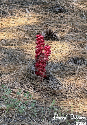
Snow Plant

Mountain Misery

Penstomen


Hartweg Lily

Mariposa Lily