Hike Info:
Type: Hiking
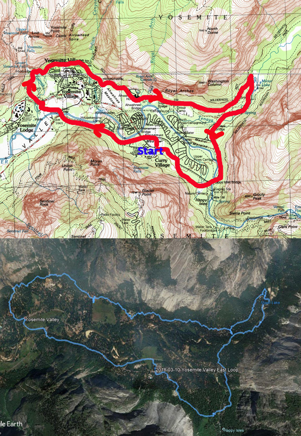
Trail: Valley Loop Trail
Destination: Yosemite Falls, Loop
Actual Destination: Yosemite Falls
Distance: 10.3 miles 1
Start Time: 9:30
 End Time: 5:30
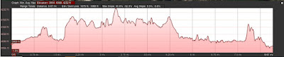
Elevation Gain: 1,676’
1 Looks like the the GPS did not accurately pick up the points, particularly within Tenaya Canyon. Consequently the points recorded were way off and could not be used accurately. The data above is derived from plotting the route on Google Earth.
Description:
 |
| Staircase Falls |
I
got up at 5:15 and we left the house a little after 6:00. 10 out of
11 people show up-the 11th turns out thought she had dropped out of
the hike. We left Fresno at 6:40. Jessi is riding with Sherri,
Steven and I. We get to Oakhurst at 7:25, filling up with Starbucks
and picking up Sonya. Then it is off to Yosemite with a brief stop at
Chinquapin
for taking care of some personal business. The line getting into
Yosemite was surprising short-about a ten minute wait. Pays to go
early. Camp
Curry
comings into view around 9:15.
A
concern which I have is that parts of the Valley can be very wet
during the Spring. With as much water as we have had this year, this
concern can become a reality.
 |
| Merced River from Happy Isles |
After
taking a group picture, the ten of us start off. We went through Camp
Curry and hit the road to Happy
Isles.
Normally when we hit the backpacker’s parking lot, we will take a
back way in. But there is usually some water on the trail, so we just
continue up the road. At Happy Isles, we stop for some personal
maintenance before setting out.
Coming
into Yosemite, we started noticing dogwoods along Highway 41. We were
wondering if it would be too early for them in the Valley. The answer
is NO! They are everywhere, from eye level to 30-40’ off the
ground. The effect is mesmerizing. So many of them and they are at
full bloom. We certainly hit it right for the dogwoods. What a
wonderful year.
 |
| Tenaya Creek |
We
walk on the Valley Loop Trail, on the easternmost side of the Valley.
Already the cameras are coming out. The dogwoods are really putting
on a show. We come to the junction where I know I will need to make a
decision-do we go around Mirror
Lake
or go directly to Mirror Lake up the road? Sherri asks a woman who
just came down the trail if she has gone around the lake? Yes. How
passable is it? My shoes are dry. Maybe taking advice from strangers
may not be a good idea.
 | |
| Washington Column |
So
off we go. I stay back with the photographers. The rest are quickly
out of sight. But the photographers are enamoured by the blossoms and
falls. They are always finding a better perspective.
 |
| Seasonal Water Fall |
 |
| Seasonal Waterfall |
We
pass by Mirror Lake with the obligatory stopping for pictures. By
now, the three of us are well behind the rest of the group. But there
is so many more pictures to be taken.
 |
| Use Trail |
We
get to Ahwiyah
Point
rock fall. And now things get interesting. What I feared occurs. The
trail is flooded. But there is a use trail around this section. This
statement is a bit misleading on two counts. First the around is at
least a quarter mile long. Which leads to the second point. The word
"trail" conjures up an image of a well manicured path
through lovely trees. While others have gone this way and several are
following us, this is a route going over rocks, under fallen trees
and through brush, climbing up about 50' above the real trail.
 |
| Tenaya Creek |
We
successfully scrambled over this, taking awhile to get around the
flooded area. The reason for all the water? The
Tenaya Creek
has found a temporary route down the trail. So with apologies to
Norman
MacLean,
I am titling this hike as A
Creek Runs Through It.
The three of us have a discussion about how far it was-300 yards or a
quarter mile. So what is the difference? 100 yards.
How
far back are we? I hope to catch up to the group at the bridge. But
getting to the bridge, no group. But more pictures. Which means a
bit more waiting. I do voice a concern about how far ahead the rest
of the group is and a nudge to move on.
 |
| Illilouette Falls |
We
pass by the Snow
Creek Trail and
continue on. But there is so much to enjoy our walk is interrupted
with more observations, both of the memory type and the photographic.
We finally come up to Mirror Lake and catch up with the rest of the
group. They have been waiting about 90 minutes.
After
a brief lunch-I had Sherri's and Steven's-we are off again. We
backtracked to the Stables Trail and take off up it. Now it is a bit
up, but not much. It goes over a ridge where Indian
Caves
are-we do not see them, but Jody has been too them. She talked some
about the legends associated with them.
As
we come down the ridge, there is a pit toilet which people makes us
of. The consensus is that they are yucky, but functional.
Now
the question is what do we want to do to finish up the hike? The
Ahwahnee?
Yosemite Falls? Straight back to Camp Curry? Yosemite Falls wins. No
need to stop at the Ahwahnee. 2.5 miles more, according to the sign.
We
make some pretty good progress. After awhile, three young ladies
pass us by and ask me about Royal
Arches.
I give them a general location and tell them that it is better from
across the way. In unison, they say, “Thank you John Muir.”
Sherri had put them up to it.
In a
short order, we go under Royal Arches. Then get to cross Royal Arches
Creek. There is enough water to make things interesting, but not very
dangerous. The worst which will happen is we will get our ankles wet.
But we all make it across safely. The Ahwahnee is close by, but we do
not stop.
But
on the north end of Ahwahnee Meadow, there is a bathroom, which we
stop to give everybody an opportunity to take advantage of it-nobody
does. The three ladies are there and we talk for a few and I direct
them to the south end of Ahwahnee Meadow for a better viewing of
Royal Arches and they scurry off.
 |
| Rattlesnake on trail - Photo by Sonya |
Now
for the big excitement for the day. For those of you who do not know
where we are, we are only about 100-125 yards from Yosemite Village,
the main place where you are going to have visitors-only about 150’
from the medical clinic and are on a paved trail where there is
virtually a continuous stream of people during the summer. Sonya sees
a snake, a cute, baby rattlesnake close to Steven’s feet. Steven is
able to get out of the way when the snake lashes out. But that was
close. I expect something like this in less populated areas, not
here. Just goes to show Yosemite is a wild, even in the more populous
parts.
Now we go behind the village,
but re-emerge in front of the Visitor Center. We do not stop there,
but continue on. But we do stop at the Yosemite
Cemetery-or
more properly known as the Pioneer Cemetery. Here many of the
pioneers of Yosemite are buried: Clark, Hutchings, Lamon-not Muir
though. We are a bit fascinated by the graves.
 |
| Yosemite Falls and Lost Arrow |
Then we move on back up to the
Valley Loop Trail. This brings us to the Falls. While I have seen
more spray than this, it was wet enough for me. Nobody sticks around
for very long to get wet. I think we are beginning to get tired.
Being cold, wet and tired just does not sound fun. But the Falls are
so awesome. Even coming up into the Falls, Lost
Arrow
standing, shining in the sun besides the spray of Yosemite Falls
gives us all pause to appreciate how special this place is. I told
the group to lookout slacklining Lost Arrow for some excitement.
 |
| Yosemite Creek |
Now we come down from the
Falls base towards Northside Drive. But first, it is time for a
bathroom break-flush toilets here. Yipee! After all have gathered, we
go over to where the buses load. When the bus pulls up, I count off
eight people from our group getting on board. Wait! Didn’t we start
with ten? Oh yeah the two photographers are still looking around. I
tell the others to go ahead and I will catch the next bus. One
photographer comes up. Then just before the bus is going to take off,
the other one comes up. We ride around for the next 20 minutes until
we get back to Camp Curry and our cars.
 |
| Yosemite Falls |
Now comes the hardest part of
the whole trip-getting out of Yosemite Valley. Fortunately it is too
early in the season for the Yosemite Gridlock to take place. But we
just get in line and progress through. Until Camp
4, we
move at 10-15 mph, but then it becomes the usually trip out. On the
way back, we stop in Oakhurst at
Plazuelas Mexican Restaurant.
See below for more. We get to Fresno, tired and happy. When I start
to unpack, I find a mysterious wallet in my backpack. Sunday, we
reunite the wallet with its owner. A pretty good trip.
Trail Lesson:
Definitely not one of the one
line spify statements which usually come under “Trail Lesson”.
But definitely something which I am pondering. We have a couple of
photographers on this trip. That is really a good thing. I learn so
much from watching others taking pictures. Both from the standpoint
of the craft, but also seeing things from a different perspective.
But to do the craft right
takes time. A few minutes here and a few minutes there adds up. The
trick to giving people time to do their craft while respecting the
time of the non-photographers, so they do not have to wait a long
time, I have yet to master. I have much to learn as an organizer of
hikers.
Background
Plazuelas
Mexican Restaurant
This is a mixed review and I suspect that with a smaller group than
nine people, the review would have been different. My group came in
after hiking 10 miles in Yosemite, hungry, but jovial. The positive,
the food was delivered fast and it tasted really good. For the food,
I would go again. I had a plain chicken burrito and enjoyed it. But I
suspect that Plazuelas was not accustomed to serving that many people
at once. They seemed to charge extra for each and every item-extra
chips, $2.50. You want sour cream a couple of dollars more. Just put
a damper on how we felt about the place.
Lost Arrow.
During our hike, I mentioned that for a real thrill, to Google
SlackLine Lost Arrow. Two which might be of interest is the first
woman who slackedline-she
falls a couple of times. The other is a person who free
walks the slackline-it
shows how the slackline is set up..
 |
| Staircase Falls and Dogwood |
 |
| Merced River from Happy Isles |
 |
| Mirror Lake and Glacier Point |
 |
| Top of Washington Column |
 |
| Meetup People on Valley Loop Trail |
 |
| Mirror Lake and Staircase Falls |
 |
| Seasonal Falls |
 |
| Seasonal Falls |
 |
| Tenaya Creek |
 |
| Snow Creek on upper wall |
 |
| Work around path |
 |
| Illilouette Falls |
 |
| Wall of Death area |
 |
| Yosemite Falls and Lost Arrow |
 |
| Yosemite Falls |
 |
| Yosemite Falls |
 |
| Gary, as always, pontificating |
Flowers and Plants

 End Time: 5:30