Showing posts with label Ten Mile Creek. Show all posts

Saturday, July 13, 2024

July 13, 2024 - Park Ridge Lookout


Title: July 13, 2024 - Park Ridge Lookout
Hike Info : DescriptionBackgroundExtra Photo's 
Hike Info:

Type: Lookout

Description:

CalFire Warning

I got up at 0530 and did my lightning report. There were some cloud-to-cloud, but none hit the ground. So the report was rather simple. I was done by 0615. Then I started working on getting the car loaded. Not much excitement here. We had decided to go out to the Train Depot for breakfast. We get there by 0850, with a few minute wait. I had a Frankie’s Omelete. Filling and good tasting It was just before 1000 before we got back, in time for Steven’s game time with his friends.

Sherri and I get the finishing touches on what we are going to take up to Park Ridge Lookout. In the meantime, I get an email asking that a couple of people want to be added to receive my lightning report. Interesting that this little niche report which I thought a few people might be interested in has become a useful tool. Anyway, Wendy and I also talked about the concerns of the day. That is lightning. Fire Weather has today with an LAL of 2, then going to 6 this afternoon. See Background below for more.

Park Ridge Lookout
By 1130 we are on our way. But first, we stopped at a furniture store. Sherri orders some sofa pillows there. By the time we leave it is 1230. Sherri drives up to Big Stump and we talk about what today might be like. It is said that normal people run away from danger while firefighters and the police run towards it. I am thinking this is more of an exercise of walking towards danger-we know there are safeguards in the lookout so, we are not too concerned as long as we take care to do our part.


I drive up to
Panoramic Point and then to Park Ridge. There is a spring which turns a small section of the dirt road into a quagmire. But we make it through without trouble. We get to the lookout at 1430. I think Peggy, the lookout which we are relieving, is glad to get out of the tower before the lightning starts. She lets us know what the status is. Seems like it has been a good morning for her. I asked her about a person I had read about in a book, Cool, Gray City of Love. Turns out she will be having lunch with her soon.

After Peggy leaves, I start bringing up stuff and then the wind starts to blow hard and the rain starts in. I am thinking it feels like it will rain hard, but it just sprinkles enough to turn the dust on the car to mud, but not enough to wash it away.
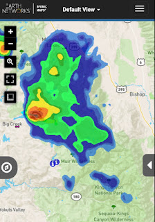
Cells in the Sierra

I hear on the radio that Division 3 and Buck Rock Lookout are talking about the status of Buck Rock. Buck Rock is saying that he is not seeing lightning. But as he says that I lookout and note a strike to the east, a little north of where Buck Rock is located. But I am not sure where the strike is as there are hills and ridges blocking my view. I relay this information to them.

There is activity down south, enough so that Peggy has said the Hume Lake area is using a different command channel than they are usually using. Turns out they got hit hard with lighting which has started several fires. One of them, the Trout, keeps getting mentioned.

On our end of the world, Buck Rock notes there is a cell going up Ten Mile Canyon. But there is no lightning seen. That turns out to be the most excitement weatherwise we have. It generates some wind and rain, but the rain is away from us. Buck Rock and us do discuss the weather and what it looks like on each other's areas.

Then we get into hearing about oddities. Not from Buck Rock, but from Porterville. A smoldering stump has been reported at Jennie Lake. Not one hit by lightning, but somebody had built a campfire into the stump and did not put it out. Maybe they did not realize how hard that would be. It is late in the afternoon, so DIvision 3 says they will send someone up there tomorrow. And then we are back to the normal interesting things like a tree falling across the road into Cedar Grove around Grizzly Falls.


Normally, we would go out of service at 1800, but we will be on extended hours today and tomorrow. Buck Rock has a drive home, so they are leaving at 1800 after checking in with Division 3.
Delilah is going out of service with Sierra, but somehow it gets communicated on Porterville’s channel. I talk with Delilah and they have it straightened out. They also had a shift change about that time and I will be talking with Delilah for the rest of my time at Park Ridge.

The reason why we have extended hours is because of serious conditions. In this case it is the lightning. I usually get to experience it during holiday weekends. After 1800, the shadows make it hard to see too much, but we look, concentrating on where visibility allows us to see. We also have our lasagna dinner-sorry, no pictures. In 2000, we went out of service.

Sherri and I get ready for bed. The light is starting to fade. But we have enough time to go for a short walk down the road, maybe about 100 yards and then turn around. The sunset is good. Between Park Ridge and Delilah, I think Park Ridge has a little bit better sunsets. It may be because Park Ridge has a nice wide catwalk facing west. After getting our reward for being up here, we settle down to our bedtime routine about 2145. I am out by 2215.


Background

LAL. Lightning Activity Level: The idea behind this item is to alert people to the potential for lightning and what type it is. There are six levels, but levels are not like hurricane levels where it designates the strength of the activity. Rather it talks about the likelihood of activity and the types. Such as a 2 says there may be isolated thunderstorms and a 3 says widely scattered thunderstorms. But a 6 says that like 3 there will be widely scattered thunderstorms, but it is likely to be dry rather than having rain associated with it.

 
 Extra Photo's

Moon through Park Ridge's stairs

Magical evening time

Last light of day

Sunday, June 16, 2024

June 16, 2024 - Bearskin Grove, Not quite


Title: June 16, 2024 - Bearskin Grove, Not quite


Hike Info:

Type: Hiking 

Trail head: Junction of 13S02 and 13S45

Trail: 13S45

Destination:  Bearskin Grove

Actual Destination:  On top of a ridge on a different road

Distance:  2.25 miles

Start Time: 2:26

End Time:  4:17

Travel Time: 1:51  (1.22 mph)

Moving Time: 1:17   (1.76 mph)

Elevation Rise:  558'

Descent: 514‘

Maximum Elevation: 6,630'

GPS Tracks


Description:
Sequoia in Bearskin

Today is Father’s Day. As my Father’s Day wish it was to go hiking, particularly to a place I have not been before, Bearskin Grove. I have seen it on the map and heard it on the radio-but more in connection with the campground than the grove. Plus a couple Facebook friends went there a couple of weeks ago, so it is fresh in my mind.

We decided to go after church. But first we need to load up the car. The car had been in for a facelift after its encounter with a deer last month. We just got it back Friday. We reload it with the necessities of life: hiking boots and poles and a few other things. Then have lunch and are off by 12:30.

The drive up is without incident. It is slow though as it seems like a good many people have the same idea of going to the mountains. Also it is Sunday and Hume Lake Christian Camps are getting a new load of their campers. But we make it up to Quail Flat and then down Ten Mile Road about five miles until we see road 13S02. Surprise! A forest service road which is paved and seemingly paved to nowhere. Where it stops being paved, the Redwood Hikes website says to park. But Hume Lake has established a drop off site there for something called Wildwood. After asking about parking there, we decided to move a little ways further down 13S02.


Steven

So I lightly blame Hume Lake for my confusion which exhibited itself when I parked. The confusion you might ask? Is road 13S45 the right road? What is the right one? The right one is road 13S98 and 13S98A. This road is 13S45. Rather than go back, I decide that we can do Bearskin another day and we will see where 13S45 leads us. It looks like on the map that we will be looking across to Bearskin.

We take off at 2:30. It is amazing how late things can be if we get a late start, have slow traffic and am confused at the start. The start of the road is steep, and exposed, and steep. It feels like around a 20% grade. We shall see how long we go, but at the latest, I am looking at a 3:30 turn around time.

The good thing about climbing up steeply is that you get to see things. First, there are the Sequoias of Bearskin Grove. The next best thing to being among them, is being able to gaze at them completely. Almost all of the Sequoias which I have seen are majestic and are worthy of our admiration.

The second thing we see is Buck Rock

Buck Rock Lookout
standing guard over the area of the forest. It is really prominent above us.-about 2,000’ higher than we are. The one thing which is lacking on our trip is a view of Hume Lake. It is out there but not visible.

Once we get close to the top of the ridge, the elevation gain starts to level out. Also we enter into an area where the trees provide shade. The walking becomes a lot more pleasant. It is amazing how the road can be the same, and yet the surroundings change, making such a difference in my outlook. Something to remember that as I continue on this road of life, there will be dry spots, but be sure to have those areas of refreshment.

At the end of the ridge, the road doubles back with a horseshoe bend. We stop here and rest and enjoy the sight. We look across the Kings with a good view of Spanish Mountain. But no view of the closer Hume Lake. There are trees blocking my view of the Mt Goddard area, so we just have to be content with some of the other snow-covered mountains to the east.

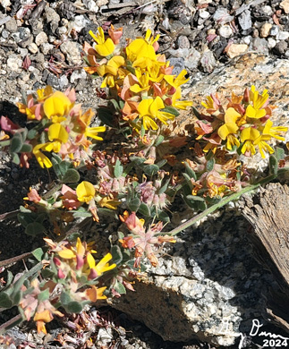
We decided that since it is close to 3:30, which is my turn around time, we will turn around now. Going down has a lot less strain on my muscles. But it is a lot more jarring to my bones. The first part back gives me many stops to take pictures of the flowers, but when we reach the section which is exposed to the sun, I am ready to get down the slope a bit quicker-not fast, just quicker than to lally-gagg around.

Sherri on the trail
But Korra has other ideas than a speedy time to the car. She catches the whiff of something, which turns out to be a deer. She gives chase and runs after it. After a minute or two, Steven calls her back, but she is not responsive. We have not heard a yelp so we think she is OK, but the concern is where is she? After ten minutes she comes back to Steven. I wonder what she would do if she actually caught the deer?

We get in the car and leave at 4:30. I drive us back to Big Stump, passing the WildWood people on the way out. At Big Stump, Sherri calls in the order to Bear Mountain Pizza and then Steven takes over driving. When we get to Bear Mountain, and I am getting out of the car, I hear the shout, Gary! Looking around, there is Brianna from Snapps, our car mechanic’s receptionist. We talked for a few minutes. She warns us that it is an hour wait, but we have ordered ahead, so it is only a ten minute wait.

After being fed, Steven takes us home. Road 13S45 is definitely not a must see. Still it was a good enough walk, particularly with the flowers and seeing Buck Rock. Looking at the roads which connect with it, I think there is a connection to some of the Forest areas behind Park Ridge Lookout where we cannot see. Maybe another day when I have more energy.


Trail Lesson:

Know where you are going before you get going.

On the road of life, there will be dry spots; that is part of the journey. Appreciate those areas of refreshment.


Background

The actual directions to Bearskin Grove is: Park on paved road 13S02; there’s a pullout just a few yards past road 13S98.

Two old logging roads run through the grove. Road 13S98A climbs through the best part of the grove. The short road is open to vehicles and is in drivable condition, although it’s a little rough. The road climbs past about 10 or 12 massive sequoias, including two especially large giants on the left that have very little taper. A lot of logs are scattered around from the 2022 fuel reduction program. From Redwood Hikes


Extra Photo's
Garlic Meadow


Sequoia in Bearskin Grove

Spanish Mountain on the right


Flowers and Plants


Snow Plant

Mountain Misery

Penstomen


Hartweg Lily

Mariposa Lily

Saturday, February 18, 2023

February 18, 2023 - Ten Mile Road - Snowshoeing


Title: February 18, 2023 - Ten Mile Road - Snowshoeing


Hike Info : DescriptionBackgroundExtra Photo's 


Hike Info:

Type: Snowshoeing 

Trail head: Quail Flat

Trail: Ten Mile Road, Road 13S45

Destination:  None-turn around at 2:30


Actual Destination:  End of improved section of 13S45

Distance:  3.28 miles

Start Time:  1:06

End Time:   3:44

Travel Time: 2:37  (1.35 mph)

Moving Time:  1:59  (1.65 mph)

Elevation Rise:  516'

Descent: 499‘

Maximum Elevation: 7,024'

GPS Tracks


Description:

Sherri
Several days ago we discussed going snowshoeing. It was too cold last Wednesday for us valley dwellers and Steven wanted to go up. Saturday looked like a good day. But what had changed in the four days or so since we made this plan? I am not sure that is still the plan. Either way, I walk over to a friend's house to retrieve my wheelbarrow. When I return, we decide it is a “go” to go up to the mountains today. It does not take us long to get ready.
Ten Mile Road

By 11:30, we are on the road. The fiddlenecks and a smattering of poppies are coming out as we approach Yokut (Squaw) Valley. Spring is getting closer. When we reach Big Stump, the parking lot is filled. So we do not even get the opportunity to use the restrooms. Onward to Quail Flat. The road past Quail Flat has not been completely plowed yet. So the parking area instead of being its usual occasional car is packed. Do we go up to Princess I think or go someplace else? Fortunately we do not need to make that decision as we spot a place to park. 


We have lunch and then get our gear on. Usually we go down Burton Road, but today Steven and Sherri head down Ten Mile Road. I am wondering is this a mistake? But the indication is they want to do something different. Steven is on skis and Korra takes off with him. That is the last we see of them for a couple of hours. I convey that I am looking at a 2:30 turnaround time. I do not have a destination objective, but even if I did, a turnaround time is good because we do not always make an objective at a reasonable time.

Gary

We watch Steven and Korra go off down the road, even though Korra keeps returning to check on us slow ones until Steven gets too far ahead. There are a couple large ruts going down Ten Mile Road. They do not look like snowmobile tracks, but I do not know what else it is. It does make snowshoeing more interesting picking our way in and out of these ruts.

We get about a half mile down and see a road going up the ridge. Steven has continued down Ten Mile Road. My thinking is going up this road is preferable, as I like going down coming back rather than slogging up a grade. Sherri and I go up, but first I leave a message in the snow for Steven in case he comes back up before we get back.

The road is Forest Service 13S45. Later on I look at a topo map and see that this is also designated as a Nordic Skiing route. The ruts not only go down Ten Mile Road, but start up 13S45.But then there is another puzzle: the tracks stop just a hundred feet in and from there on is virgin snow. Looks wonderful.

Spanish Mountain

Both from Ten Mile Road and from 13S45 we see across the Kings as well as Buck Rock. But the views for the most part have trees framing the scene or intertwined in it. Still, there is something which is appealing looking out over this section of the Sierra (actually there are very few sections of the Sierra which I feel are not worth looking at.)

We go up about a half mile up 13S45. It has good solid snow, which has been settling for a couple weeks. So walking on it is a pleasure. Even I am able to feel good going up the slope. One drawback: there are no dramatic views. “Only” trees and snow are what can be viewed.

It is getting close to our turnaround time. Sherri is ready to go back, but I would like to go on up a short way to a horseshoe turn. So I leave Sherri and continue on up. I get there in a couple minutes. The road starts to level out and since I have about seven minutes to turnaround, I continue on. I quickly came to the top of the ridge. And lo and behold, there is my view! I can see across the Kings to Spanish Mountain and the Obelisk. Looking more westward, there is the Patterson area. Then closer to me, there is he basin where Hume Lake is. And by Hume is a smoke cloud. Wait Smoke! I remember that the Forest Service was doing some burning in the area. This must be it.

Indian Basin Smoke

After taking a few pictures, I head back down. I got to the place where I left Sherri. I see her tracks heading back. I just follow these tracks down. And about a quarter mile later I caught up with Sherri. Down we go. Sherri and I both think this is a trail we will be doing again.

We get to the junction with Ten Mile Road. I check the ski tracks to see if Steven has been by. I only see his tracks going down. So I erased my message. Sherri goes on ahead while I lag behind to see if Steven will come around the bend. By my calculations he is anywhere between right behind us to 45 minutes.

There is a reason why I wanted to go UP 13S45 rather than further down Ten Mile Road. From the junction we back up to the car. I stop every so often to look behind, but no Steven=it also gives me a chance just to take a small break. After a while I hear a mechanical sound. A minute later, a Toyota ForeRunner comes into view. This is an ah ha moment. Now I understand the mystery of the tracks. They are vehicle tracks, not snowmobiles. They pass by and I go on. Shortly before the parking lot, I caught up with Sherri.

We get to the car around 3:45 and start putting away our equipment. Steven gets in as we put stuff away. And then it is off to go back to Fresno. It is a pretty easy drive back and we get back home at 5:20. Another good day.


Background

Smoke. The smoke was from a pile burn in the Indian Basin area which Sequoia National Forest had set. This was part of an effort to clear fuels from around Sequoia groves throughout all forest lands. Indian Basin close to Princess Campground. We would have been right in the middle of the smoke if we had gone there.


Extra Photo's


Snow and Pine Cones

Patterson and Spanish Mountains

Stack of rocks by Ten Mile Road

Buck Rock and its lookout

Looking to the northeast


Sunday, September 25, 2022

September 25, 2022 - Princess Campground and Big Stump


Title: September 25, 2022 - Princess Campground and Big Stump
Hike Info : DescriptionExtra Photo's
Hike Info:

Type: Hiking 

Trail head: Princess Campground

Trail: Indian Basin Interpretive Trail

Destination: Loop

Distance:  1.0 miles 1


Type: Hiking 

Trail head: Big Stump Parking Area

Trail: Big Stump

Destination:  Loop

Distance: 1.52 miles 2

Start Time:  2:10

End Time:    3:19

Travel Time:  1:08 (1.34 mph)

Moving Time:  0:56  (1.63 mph)

Elevation Rise:  503'

Descent: 203‘

Maximum Elevation: 6,381'

GPS Tracks

 1No GPS track. Just an estimate 

 2The GPS got turned on about an eighth of a mile along the trail after descending a ways. So the proper distance is about 1.67 miles

Description:

Gary getting ready for breakfast
It is our 46th anniversary! What better way to spend it but by doing something which both Sherri and love-camping! Well maybe backpacking might top it.

Last night was cold. Sherri was up a lot last night-I only got up once to relieve myself. But my mattress had deflated. I got up at 7:30 while Sherri got up at 8:15. I read and had my quiet time. It is pancakes for breakfast. We discovered that the eggs were left behind. That may put a damper on french toast tomorrow. But the mix can be used without eggs, just a bit more satisfying. I mixed up the batter and discovered I had put too much, way too much, mixture in. We will be substituting pancakes for bread at lunch and probably have enough for breakfast tomorrow. It could be worse.


Clouds rising above a ridge
In August we took John and Cathey on the Indian Basin Interpretive Trail by the campground-we have also snowshoed this a couple of times as well. We did this walk just to get our legs stretched out and to enjoy the morning without much of a strain on us. We heard a couple of gunshots to the northeast of us-we are on Forest Service land and deer hunting season started this weekend. While we feel pretty safe here, the pop’s can be a bit disconcerting.

As mentioned, Sherri was up last night, so our mile walk was enough for her. When we got back to camp, she was OK sitting in a camp chair, then taking a short nap in the tent. I had some hammock time. I do not have it set up right. I am missing a carabiner, so I have improvised. My butt is rubbing against the ground. We had our pancake, peanut butter and Nutella lunch. Now to decide what to do.


Gary crossing a downed Sequoia


I am not terribly energetic and Sherri is even less so. We will save doing the North Boundary trail up to
Panoramic Point for another day. The Big Stump loop sounds like a good walk and just about what we need to do. We go back to the Big Stump Parking area where the Dark Sky viewing was held last night.. We grumble about a van with high school students who decide to park in a red zone next to the bathroom-you would think they would have more ability to walk a few steps than a couple who are a year from seventy.

Enough grumbling. It is a good day and we start down the trail. We notice that a new trail is being put in. Maybe next year it will be usable. We quickly get to the reason for the name of this area. We wander around, coming to Big Stump Meadow. Even get to walk across a fallen Sequoia. We come to the far end of the area and see the Mark Twain Stump. This stump is huge. I wonder what it looked like before the loggers got to it (just saw from the link, it was not the logger, but the US Army which wanted to prove how big these trees were.).

Sequoia


We cross the highway to continue on with the loop. This takes us above the area, where we can catch glimpses of the grove. Once the trail does its short rise, we more or less follow the mountain contour. It is a bit more sunny and a bit more warmer, but pleasant. We stop and sit on a pine stump to enjoy and relax a bit. A short way further, we descend to go under the highway, through a tunnel. This leads us back to the parking area.


Mark Twain Stump

Instead of just going back, we took a drive down Burton Road. I was hoping to make Little Boulder Creek and see if the trailhead is now open-it is not and will be closed at least until August 2023. But it is a long drive and when I see a sign saying 5 miles further, we decide to turn around. I had forgotten how long of a drive it was. Still this is a very pretty drive with to die for views of Kings Canyon and beyond. When we got back to Quail Flat, we returned via 10 Mile Road. This will be closed until next year starting tomorrow. We descended and drove by Hume Lake. Then onto Princess Campground.


Night sky-with false coloring, from Indian Basin
We got back to our site just before 5. I start off by blowing up my air mattress. After 45 minutes, it still is not firm. Sherri makes us dinner of grilled cheese sandwiches and soup. Hits the spot. We wait until it gets almost dark and then take Celeste down to the Meadow. She is decent at seeing things a bit closer. While last night, we were spotting far away clusters and galaxies, tonight we are into planets and stars in general. Saturn is already up. Then Jupiter rises above a ridge in the east. We enjoy the night sky for 45 minutes before we head back to our little cloth abode.


Our 5 star room
We manage to climb into bed by 9. My mattress is already deflated. I read until 9:30 and then close my eyes for the night.


Extra Photo's

Night Sky

Did Jupiter really move that much in 20 seconds?

Gary on the Big Stump Loop

Big Stump Meadow

More of Gary walking the Big Stump Loop