Showing posts with label Mineral King. Show all posts

Friday, July 4, 2025

July 4, 2025 = Park Ridge Lookout


Title: July 4, 2025 - Park Ridge Lookout


Hike Info:
Type: Lookout
 
Description:

Chuck's Flag
Maybe I learned my lesson from yesterday. I got up a few minutes earlier. But that was futile as there was no lightning to report. I am glad of that. I got up and started packing as today is my last day in the tower. I get about a third of my stuff down. At least that is a start. Wendy had asked for a new US flag to be put up. Her late husband had wanted that to occur each 4th of July and I am happy to be the one this year to carry on that tradition. I wanted to get a picture of it at sunrise with the wind unfurling it. But the wind did not cooperate. Later it unfurls.

I am able to go for a short walk, maybe a third of a mile. But this feels good. Then back to the tower where I have my breakfast. At 0800 I went into service with both Porterville and Ash Mountain Fire. About 30 minutes later I realize I have not heard either Buck Rock or Delilah go into service. I phoned over and had a conversation with Jeff. Both have gone into service. Maybe they got lost in the static. Or maybe I need to clear ear wax out of my ears. Then it is off the normal duties of a lookout.


Early Morning light
 

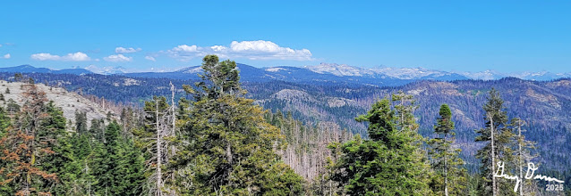
Bluebird sky days are a joy to a lookout. When you have haze, it is tough to make out anything and your eyes strain to discern objects. The white of the smoke blends in with the dinginess of the air. But today is a day which I can see almost forever. I can see the foothills of the Coastal Range plainly along with its tops. I suspect if I was at Delilah, I might be able to see into Yosemite. A day to love being up here.

On this kind of weekend you get to hear interesting stuff. At the Crystal Springs Campground a cooler and trash can was impounded. I am assuming that foodstuff was not put away and people were not around. Sounds like a bear hazard to me. Or then there are maybe too many people in a place at one time. The Wolverton Road was closed to traffic due to both congestion and too many people parking alongside the road. Just heard that Lodgepole road is closed as well, except for those going into the campground.

Then this morning as I was doing a scan, I noticed a marmot eyeballing my car. It seemed hesitant to approach it. Yesterday someone asked about marmots and I talked about how cars over in Mineral King had to take preventative measures. So I watched him pretty closely. When he goes under my car, I hurry down the stairs to scare him off. But he emerges from the other side and eyeballs me, like he should be the one who is concerned about me. He runs off to some rocks and I resume my lookout activities.

Coastal Range


Wendy called me up and told me that my relief is expected to be here around 1700 or 1800. He will call me up. Also talked about some wildlife Buck Rock saw this morning. Things could get interesting if this sighting is verified.


My Favorite Marmot

Fuzzy's Bench

Now I am hearing a woodpecker tapping out his staccato beat on a tree. Another joy of being up here is seeing and hearing the sounds and sights of nature. I wonder what the woodpecker is going to hide and will he remember where he has hidden it?

Lunch, or dinner, is the remains of a couple enchiladas which Sherri made for lookout. I cleaned up the dishes in preparation for leaving this afternoon. This is just the start of cleaning up the cab, not that I had created a huge mess or anything. Still crumbs fall and things get spread out.


Yesterday there was a fire near Marvin Pass. Yesterday when I looked on WildCAD I saw it as the Gammon Fire. Usually fires are named after some landmark around it. But there was nothing in the area we saw with Gammon nor could I find it on GNIS. Today I was hearing the Incident Commander Trainee calling himself the Gannon IC Trainee-with two N’s. I looked on WildCAD and it said Gannon. There is a Gannon Creek there. When I looked on GNIS, it had been named in 2000. Most of our maps are pretty old, so it is no surprise that we could not find why it was called the Gannon fire.

The last two hours of a shift, particularly on leaving day, are the longest. I am expecting that call saying when my relief is coming. And as that is not coming, the time is even longer. Still there is only 7,200 seconds to count. During that time I get the fire indices, clean the floor and countertops and pack the last of my stuff.

This has been an unexpected day. It is the Fourth of July. I was expecting a ton of visitors. Instead, there was not a single one. At 1800, I go out of service, and start back. I meet my relief on the road. We exchange greetings and I relay some information to him. And then we are both on our way. A short way further I realize there were a couple more things to tell him and leave a voicemail. It is an uneventful drive back home, arriving shortly before 2000.


Menu

Breakfast

Lunch

Dinner

Snacks

Granola

Enchilada

Peanut Butter and Nutella Sandwich

Ritz Cracker, Granola, Jelly Belly


Saturday, September 5, 2020

September 5, 2020 - Delilah


Title: September 5, 2020 - Delilah
Hike Info : Description : Background : Extra Photo's 
Trail head: Delilah Lookout
Hike Info:
Type: Lookout

Please note: This is not a record of the Creek Fire. We were at Delilah Lookout, 25-30 miles away from the action. Below is a combination of my recollection, Forest Service radio communications, text and e-mail conversations with those who know fire. Consequently, this blog entry should be read from the perspective of a person who had a narrow, but interesting window into fighting the Creek Fire and the rescues which all the first responders achieved.

Description:

Got up at 0615. Looked around and saw smoke, lots of smoke. Also did my lightning report which came back negative. Buck Rock and I talked some. He has some pretty clear air, I cannot even see McKenzie Ridge, which is just across a valley from us. This may be a long day.

Went down out of Delilah for a few minutes. Made sure we had enough water for the day. Then back up. Sherri also goes down, but needs to stay down a bit longer. You know the bugs I talked about from yesterday? They have invaded the lookout cab. So we spend some time exuviatingg them as we find them.
Pumpkin Bugs


I go into services at 0800 with 3-4 miles of visibility. Also this bodes ill for today: the RH is 18%-getting pretty low. I can taste a bit of the smoke in the air from the SQF Complex fire. But that is not the excitement. Even before I go into service, Buck Rock and I are talking about the Creek Fire. He has a fabulous picture of the cloud from it. I get my view in. They both look awesome and ominous. I would guess the pyrocumulus rises up at least 6,000’ up in the area. Later we hear this guy is huge, maybe the biggest pyrocumulus cloud in the United States, ever! That cloud continues to morph, shapes and grows all day until it gets hidden by, ironically of all things, smoke. Eventually it goes up to being 50,000’. We have heard that the fire is now 500 acres.

There are a couple of different threads on the fire which I was participating in. The first is to the OSHER book group. You know this is the one I talked about yesterday. Kay was wondering if there were any suggestions about the Zoom meeting. Well I just noted that if anybody was thinking of going to Shaver or Huntington, don’t. This helped one of the people’s granddaughter to get prepared to evacuate even before the warning was given. And then for the next several days, there was concern about us and the fire. We are over 30 miles away.

Even before the Creek Fire gets going, Sherri is wondering ab

out the smoke. Our friend and fellow lookout, Judy, offers to come up and take Sherri back to Fresno. After a couple of hours, Sherri decides it is not getting worse, so she will stay.

That will pretty much be the story of the morning and actually most of the day. But most of the afternoon we are voyeurs. We listen to the happenings going on across the way. We heard them fighting the Creek Fire, calling in air drops. By 1020, the reports were that the fires had leapt up to 2,000 acres. A little after noon time, the fire is at 6,000 acres. We are getting winds up to 25mph from the south. And we are hearing that the air tankers are having to back off due to turbulence.

That is wild. Then the winds start to pick up. This starts to drop fire six miles away at Clearwater and Hogue Ranch. The first responders try to get as many people out as they can. Both sides of Road 81 are burning. Tees are falling, blocking access and more importantly, ways of escape.

Then smoke is reported from the Cascadel Woods area. First responders are sent to that area and evacuations are started there as well. Then another spot fire is north about five miles. More first responders are called in. Now the first priority is to get people out of Mammoth Pool. But when the first rescuers get there, the road is blocked with burning trees having fallen across the road, fire raging on both sides. They cannot get in that way, and there is only one way in or out.


There are a couple law enforcement officers controlling this phase of the rescue. They understand that the first rule of rescuing people is do not make the situation worse by putting yourself in complete danger so that you now need to be rescued. So the controller knows there are others who need to be rescued and that even if they could get to Mammoth Pool, there is no way they could get these people out. The best they can tell the people is to get into the water.

The rescuers retreat and continue on up Road 81 They are directed up and down these little dirt roads, telling people to get out. There are dispersed campsites where people are staying, there are people out hiking. There are people coming in on horseback. The first responders are searching them all out. Now roads are getting closed down because the fire is rapidly expanding. 


Smoke Main fire on right and spot fires

To complicate the matter, there is a bridge under reconstruction near Bowler, so they cannot take people out the best way and the way mostly away from the fire. So they need to go over Grizzly Meadow Road, through Lower Chiquito Campground. But that quickly gets shut off by a spot fire surrounding a small segment of the road. There is one other dirt road which skirts the fire, road 6S44. But you hear comments to make sure they have a high clearance vehicle. Evidently it makes an already nerve-wracking experience even more so.

We hear of the fire’s expanding range. Now it is on both sides of Mammoth Pool. Also it seems to be following the San Joaquin River and route 81. The first responders are not keeping ahead of the fire. Occasionally you hear of someone being reported that someone does not want to evacuate. The law enforcement officer says, take a picture of them. That sounds rather ominous.

Lightning map around Mammoth Pool

If that is not enough, you know that pyrocumulus cloud we saw earlier? It is creating its own weather with lightning strikes just to the north of Mammoth Pool. Truly a dangerous situation. Turns out the strikes were between 1430 and 1500

One of the rangers knows there are backpackers up at Lillian Lake and beyond. He is given permission to hike in and notify them to get out. A couple of hours later you hear that the majority of them do come out. But a couple of them feel they can go further away from the fire. We are only hoping that they made a good choice as there will not be many options open to them otherwise.

The chaos of getting people out and getting in front of the fire is starting to calm down. This is only a relative term. Sierra’s radio continues to crackle on both channels. The air attack has been trying to lay down retardant to slow the growth and to redirect the fires away from places where there are people and structures.

Meantime, lots of people need to get out of Huntington. The fire is threatening to cut off the exit via 168. They have some people at China Peak and plotting how to get them out.

In the middle of the afternoon, Wendy heard of a report of a plane going down in Sequoia. Looking at WildCad, It turns out the plane went down close to Mineral King, around Eagle Lake. Not that everybody did not have enough to do. Found out later the occupants died.

A friend of ours is the campground host for Chilkoot Campground along Beashore Road. This is where our family stayed last June. We text him and tell him what is happening. He says that he will be leaving soon.

By 1735 the fire was 36,000 acres. The conversation thinks it is more. By 2039, it is 73,000 acres. We heard at one point a plane was trying to map the fire. There was so much heat being given off, it sounded like he was giving up mapping it and would return with the data he collected.

Looking towards Pinehurst

By the way, we still did our lookout responsibilities. Taking weather, doing scans, listening to the radio, … But frankly, even during a normal year, Delilah is known for its solitude, broken only infrequently by guests. On the other hand, Buck Rock, close to Big Meadow, can be a hive of activity. He does relays of radio messages from patrols to patrols or Porterville, he has eyes on activities, mostly legals, but sometimes, not so. The patrols in the area are called to break up an argument. Such as a group thought it would be cool to drive on top of Wedding Rock, past barricades and have a good time with a campfire. Buck Rock spotted them and let those in the area know.

Fading Sun


Our day gets done at 2000. But we are slow to turn off Sierra’s radio as I would hesitate to say entertaining, more like mesmerizing and addicting. The activity, the intensity, the calmness they all approach their job with. But with the fading sun, comes darkness. And with the darkness, we look north and see flames surrounding
Musick Mountain 27 miles away.


Fire around Musick Mountain

Before I go to bed, I have a text conversation with Kathy. She was wondering how we were doing today. It is exciting to hear the goings on. Also it was hot, but not bad enough for us to leave.

Reflection: Sherri and I have hiked and driven a lot back where this fire is raging. There is a lot of sadness. There is the hope that the land will come back, there is a hope that in a decade it will be restored. But there are also the people who are being devastated. Some have only been there for a few years. But many go back five, six, seven or more decades. Much sadness. We will only know when things open up again, probably next Spring.


Background

Apparently this is not the first large fire in that area. Back in 1994 Buck Rock was able to look down into Big Creek and pick out a smoke. She reported it.


Extra Photo's

Afternoon smoke columns


Pyrocumulus

Pyrocumulus

Pyrocumulus

Bear Mountain-Fresno

Bear Mountain-Tulare

Fire on Musick Mountain

Fire on Musick Mountain


Sunday, October 13, 2019

October 13, 2019 - Delilah Lookout


Title: October 13, 2019 - Delilah Lookout
Hike Info : Description : Background : MenuAnimals 


Trail head: Delilah Lookout
Hike Info:
Type:Lookout
Description:
Deer in the morning
Seemed like whichever way I turned my head last night, I ended up with a headache. Eventually got up at 0645. Just sort of mozied around until Sherri got up. Then we had breakfast and got ready for the day. It is the usual stuff as we take our stuff down to the truck-today is the last day of our three day stint up here. It might be the last day at Delilah for the season.


To back up a bit, while I said I mozied around a bit, I did enjoy the morning light coming over Park Ridge. The shadows from the ridges recede from the golden sides. The air is still and all is quiet. It is a good time to be up here, even if it is a bit cool. Or maybe the coolness helps to enliven my senses.
Deer Love
At 0929 we go in service with a low RH : of 15 to both Sierra and Porterville. We then settle down to our routine of scanning, radio listening, and identifying places. Sherri and I talk a bit about our experiences, or lack thereof, of identifying smokes. As you go through this, you learn the terrain better, so that part is faster in figuring out where the fire is. Also you understand it is good to get an approximate location out to the Forest, then give them more details. We are still working through what is a real smoke and what is an illusion.


Is there a smoke close to Nelson?
As if right on cue, Sherri sees something suspicious. Is it a smoke? Or is it a haze or something else. We start figuring out where this is-the South-Southeastern flank of Mt Nelson, probably about 17-18 miles from us. Whatever it is, looks like it is behind Poison Ridge, probably past the McKinley Grove area. But it does not look like anything is really showing. So we monitor it and continue to try to figure out what we are seeing. We get Celeste involved, but Celeste only sees trees and granite. Then Kathy calls, our expert in all such things. She gives us some recommendations, including talking to Buck Rock and Sierra’s Battalion Chief 42. Sherri calls Buck Rock, but does not see anything, so we are content to monitor. As time goes on, the haze clears out and the white rock gets more visible.
By this time, it is lunch and we have our sandwich, between scans. Our looking around continues, with not much exciting. To tell you what keeps us “entertained” is we are listening to an incident way to the south, beyond Mineral King in the Sherman Pass area. A SPOT message was received and an ambulance is sent and keeps asking for directions about where to pick up the victim. We keep wondering, where is Sherman Pass? We figure out where it is and start thinking about visiting it one of these days.
It is getting close to quitting time. As the days shorten, so does our duty houses. We will be going out of service at 1630 today. But at 1600, we hear a report off of Dinkey Road at the Bald Mountain Trailhead that there is an out of control campfire. It will be named the Glen Fire. A passing contract logger calls it in. can we see it? No, but we do look for it. Sierra is on it right away. It will take the next 7 hours to put it out, but they caught it early.
A bit of orange close to Garlic Meadow
At 1630, we go out of service, getting packed up. Sherri notes that it took awhile for us to get out of the lookout today, about 40 minutes. But thinking about it, the Glen Fire got us occupied close to quitting time, so we did not get things ready before the end of our shift. We meet Steven in Fresno and go out to Sweet Tomato’s for dinner.
This may be our last time at Delilah for the season. The next weekend is unstaffed. We are over at Park Ridge Thursday and Friday, but have told folks that if they want us over at Delilah, we are willing to shift over, whichever is more important and is harder to staff.

Background
RH. What is an RH? it is a measurement of how much humidity there is in the area. Less than 20%, the forest wants to know about it. At this level, any spark can take off, particularly in the dry grass we have at this time of year. More than about 60-70% it is awfully hard to start a natural fire


Menu


Breakfast
Lunch
Dinner
Snacks
Oatmeal and add-ins, such as dried peaches, strawberries, nuts, granola. Tang.
Sandwich: Peanut Butter, Nutella
Sweet Tomato’s in Fresno
Almonds and String Chees

Animals

I see you

Not a salt lick
More deer love

Monday, September 2, 2019

September 2, 2019 - Delilah Lookout


Title: September 2, 2019 - Delilah Lookout
Hike Info : DescriptionMenu : Extra Photo's : Animals 


Trail head: Delilah Lookout
Hike Info:
Type: Lookout

Description:


I have said many times that the evenings are worth being a volunteer up at Delilah, but the mornings are really not worth waking up to. Usually the sun just pops out in back of one of the ridges with little or no fanfare.
But this morning was different! First, I wake up entirely too early at least by 0515. I am trying to convince my eyes to close and go back to sleep. But there is a flash of light in the north west corner of lookout’s cab. Who is down below flashing lights at us? So I quietly get up look around from the catwalk-there is a sturdy gate between us and anything down there, so I am not concerned about an intruder. Then another bright flash of light happens, this time from the southeast-lightning! (The flash on the northwest was a reflection.) I see several more flashes about two minutes apart. It looks like it is in the Giant Forest/Alta Peak direction. Later when I looked at a lightning map, I see that most of the strikes are to the east of Mineral King. Now that is how a morning in a lookout should start.
Clouds glowing
But wait, there is more! Now that the lightning is done with its fireworks, I can observe the clouds. And the clouds are the second act in this morning’s entertainment. There is gray clouds spread in bands to the east. Even with the dark skies, I can see that clouds have accumulated all around us. Last night around 0230 I had woken up-overhead was stars, all around us was clouds.But now, there are hints of the sun coming turning clouds golden. Each minute more clouds get bathed in light, even the showers of rain in the distance have a light to them.

Sunshine and Rain
Now the sun is up, much of the color fades. But in a little while we have an encore act. Kathy has told me that it has rained in Pinehurst. But from here, we can look out around us and see where rain is falling. Then the sun breaks through and shines in what looks like smoke, but is mist on Mill Flat Creek. The light just shimmers across it. Then a bit of water falls on us, but nothing which registers in the rain gauge. Not a bad encore.
Sherri wakes up around 0730 after most of the excitement happens-she is there for the falling moisture. But we start getting ready for the new day. By now you know, we fix breakfast, get cleaned up and ready to go. The radio goes on at 0900. I talk with Buck Rock about the lightning. Then we go into service around 0930. I also talk with Park Ridge about the lightning after they go in-service.


Just before 1000 rolls around, the phone rings. It is Patrol 33-the real Patrol 33, not the voice we have been hearing on the radio the last couple of days. The voice is a ride-along person who is usually on horseback. Patrol 33 would like us to do a relay to a work crew to meet up with them. Because of our location and height, we can reach places which coming out of Big Meadows is hard to do. So I use channel R5 Project to try to get a hold of the work group. No success. But about half an hour later, I hear Patrol 33 on the radio and they do meet up. It was good to hear that voice.
Haze view vs haze filtered out. Looking up the Middle Fork of the Kings
It is getting close to lunch time, but then we hear a smoke has been spotted along the Dinkey Road, close to Swanson Meadow, at the end of Blue Canyon. We can see into some of that area. So we start scanning the area but cannot see it. Several Sierra Forest Service personnel are now searching for this smoke and not finding it. We at Delilah ask for clarification about the location. We also communicate we do not have visual on the smoke. Then an engine going up the four-lane to Shaver spots a smoke on the other side of Pine Ridge-the one close to Shaver. It is on the far side of the ridge, so even if the air was cleaner, we could not see it. Turns out this was the smoke-so we feel better that it was not us being blind.
Hummingbirds
That little episode gave us a half-an-hour of excitement. Then we had lunch for a few minutes. Then the afternoon was more of what we had been experiencing this weekend. Except it seemed that a lot more abandoned campfires were being found. We continued to do our scans and listen to anything relevant for our area of interest.
Sherri, the hummingbird whisperer
That is Sherri is the official hummingbird feeder for our team. She has already cleaned and refilled it once this weekend-it is amazing how much those birds will drink. But now the bees are taking over. So Sherri has the feeder taken down and put away until the bees go off someplace else-that will probably be a couple of days.
I will admit I was feeling a bit tired this afternoon. After doing a scan, I would lay down-could not really nap. Then talk with Sherri or read a book. Then back to doing a scan. Glad we did not find a smoke. But also hoping that if there is one out there, that we would find it. Someplace in there, we do some cleaning, like mop the floor. Looks better.
It is getting close to 1800, our normal quitting time. But do we go to 1900? Sierra does their checkout routine and so both Buck Rock and us go out of service. I call up Buck Rock to find out what the plan is. She is going out of service, and so will we. But we are slow in packing up and it takes us about half an hour to get things cleared and cleaned out. It seems like we keep on finding new things that needs to be taken care of before we leave.
Having been to Delilah often enough, we know that we can phone into Bear Mountain Pizza at a certain place and say we will be there in 45 minutes. We are feeling rather tired so that is a good option for us. Food always rejuvenates. We get back to our house around 2100, ready for a shower and a good night’s sleep.

Tuesday Note: Kathy called me up and asked if we had any unusual visitors? Nope. We had a pair of two legged types on Saturday who came over from Buck Rock. There has been a couple low life four legged types hanging around the tower-not sure that I trust them. They look cute, but you can never tell. Then we have seen these bandits with busy tails-definitely do not trust them. How about the flying type? Nope. The person who came in Tuesday, when he opened the cab door, out flew a bat!  

When did the bat get in the lookout? We do leave the doors open all night, along with the windows-gets really stuffy in there. But we did not see the bat hanging around. We also cleaned up so it was not in an obvious place. Guess next time I will be a bit more careful.


Menu
 Breakfast Lunch Dinner Snacks
Oatmeal and add-ins, such as dried peaches, strawberries, nuts, granola. Tang. Ritz Crackers, Tortillas, Peanut Butter, Nutella
Clif Bar, GORP, Propel, CytoMax, Scratch, Coffee Candy, Jelly Belly


Extra Photo's
Morning Skies


Virga

Sunshine through the Rain
Clouds to our Northeast

Verplank and Hoist Ridges

Hummingbirds and Rodgers Ridge

Space ships disguised as linticular clouds

Animals