
Hike Info : Description : Extra Photo's : Animals
 |
| View of Delilah from the road in |
We begin our last time at Delilah for the season. The schedule is for us to be here for three days. With a friend coming up Sunday and having dinner with us. But until then, we need to get up there. I am a bit concerned with the cold which we might face. I think I have enough clothes.
I got up at 0525 and got myself ready. Had my normal breakfast. Sherri gets up at 0600. I have the car loaded by 0700. But we do not leave until 0715. I am thinking we are running late, so I do not suggest a stop at Clingan’s Junction. The road to Delilah has improved during the past year. Instead of taking 45 minutes from getting off of 180, we make it in just over 30, About 0850. Then it is the usual, hauling stuff up, both on our back and through the pulley system.
At 0928 we go in-service to both Porterville and Sierra. About this time I see where Richard, who is the Delilah lead, says that with the storm coming in Monday, Delilah will close a day early. Now to figure out arrangements with our friend.
At 1000, Sierra catches me a
bit off-guard. At 1100 they do their lookout check in, but I guess
with shorter hours, it is 1000. But I recover fast enough and answer
their call. Shortly after this, I hear Porterville trying to reach
the Happy
Fire IC.
I offer to do a relay and they take me up on it. But after several
call outs, I saw No Contact and told Portville this. A few minutes
later, there is a faint call from the Happy IC, but I cannot get a
response from him. 
Haze from the Happy Fire
Shortly after this, I hear
Patrol 33 is going for a walk up to Weaver
Lake.
There is a small fire going through up there. An hour later we hear
that the Weaver Training IC and two of his co-workers are also going
up there. A couple hours later, the IC is at Weaver and notes that
the fire is about 0.1 acres from a campfire. They dug a ring around
around the fire.
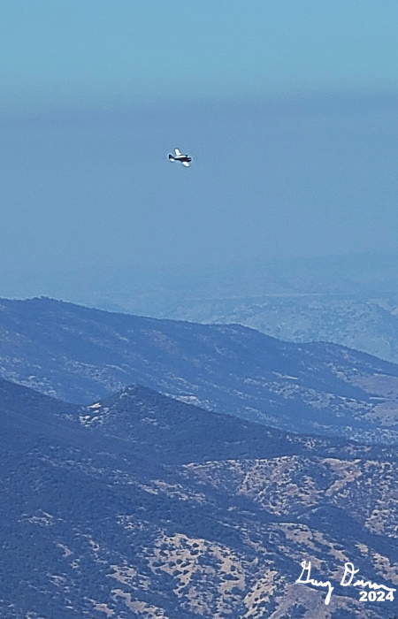
Mystery Plane
Back to the Happy Fire. The IC initiated a test fire. This is to see if the area they want to burn will do what they want. It was successful. So they proceeded with today’s burn just before 1500, we hear that today’s burn was completed and that about 155 acres were burnt.
On our side, it was just good
to be up here. We did our lookout stuff. In addition, we were asked
to count the visitors we have had this year. The grand total was 219,
assuming none come up tomorrow, from countries like the Netherlands,
Germany, Denmark, Iowa, Washington--well those last two are states,
It is interesting that somebody will come half way around the world
to get a view from this tower.
Afternoon Happy Fire Smoke
 |
| White Deer Road |
While doing one of my scans, I hear a noise like a truck engine. I look around and do not see anything. But a little while later Sherri is doing her scan and is following a hawk. Then hears a sound like a helicopter. But when she points out where it is coming from, I see a very quiet plane. It leaves the area. But later on Sherri sees it again and it just goes over Pine Flat and turns back towards Reedley. Finally an hour later, I see it and it does the same thing. We are left wondering, what is it doing? My first impression was that it was helping with the Happy Fire. But after the other two patterns, it looks like it was either training somebody, mapping the area, or looking for marijuana plants. We will never know, so we are free to speculate.
 |
| Ravioli Dinner |
Because of the shorter daylight time, we go out of service at 1530. Shortly afterwards, we go for a walk, down the hill Delilah is on. Normally we walk up the Delilah Road, but the White Deer Road looks like it is available and we only have gone down this road once and only for a short way. It is westward facing, so it catches a bit more sun in the afternoon.The one disadvantage to this road is that it goes down. But we go down the road, descending maybe 300-400 feet. When it gets to the place where it rounds the ridge, it continues the descent. Sherri and I looked at each other and said we have had enough downhill. We return and get back to the cab around 1700.
We read and talk and read some
more. I am looking at one of Sherri’s books, Francis Collins, The
Road to Wisdom.
This is the optimal use of being alone, in the quiet of the
lookout-to read, to think, to meditate, to pray. Unfortunately I am
only good with the first. By the time I look up, it is dark. I have
missed that moment of transition between day and night, that time
which the setting sun exits. But we still have the moon.
Around 1800, Sherri fixed us the ravioli we were going to have Sunday with Judy. Tastes good. It is leisurely. Usually dinner at Delilah is looking out over the fading sunlight. This is darkness, a bit more intimate. We just enjoy each other’s company.

Down to the outhouse we go, then lock ourselves in. Even with the moon shining pretty good, we enjoy a bit of stargazing. Then around 2100, we turned in.

Extra Photo's
 |
| Star over Fresno |
 |
| Autumn Leaves |
 |
| Fence Meadow Lookout |
 |
| Autumn Leaves |
Animal
 |
| Outhouse Spider |


