Showing posts with label Davis Flat. Show all posts

Friday, May 19, 2023

May 19, 2023-Delilah


Title: May 19, 2023-Delilah

Hike Info:
Type:Lookout

Description:

Slept well last night. I woke up to an early morning light around 0500. The subdued orange and pinks of the early morning is always pleasant. The other good thing is, I do not need to get up to enjoy. I just can lay in bed and look out of my glass house. Just before the sun comes up, the area behind Split Mountain gathers light with intensity.

Around 0530 I start gathering information for the day’s lightning report. I know there was some activity because of the clouds I was seeing and the alerts I got. But it turned out there was only a single cloud-to-cloud which nobody cares about. So I do not need to send a report.

I mosey around the rest of the morning. Mich had sent out an email about Delilah which others responded to. Since I am the only one on scene, I take this time to respond. Also I talked with Greg about the water situation. Breakfast is granola and lemon bread, which Wendy gave to me yesterday.


Patterson Falls

Rancheria Falls


I took the weather for the morning. Nothing alarming. Wendy alerts me through a text that I will be doing a relay for Patrol 33. Not five minutes later, P33 summons me and I do it. Yeah! One of those radio things I feel I can easily screw up. I hear Engine 32 go into service to Delilah LO. Company today! And all of this is before I go in-service


At 0933 I go into service with both Porterville and Sierra. Then I start washing windows between doing scans. P33 lets me know that her crew will be raising dust along Davis Road. And I see her convey of trucks heading down, marking areas for drivers to be cautious of. At 1000 Porterville gives the weather forecast. P33 and her gang gets close to Sampson Flat, taking care of some logs and trees. Then at 1100, is the Sierra Lookout check in. Another lonely day-I would not trade it lightly.


Hillside shift above Davis Flat
This gives me a chance to review my area of the world. Usually when I am up here, there is so much which is dry. As I look across the Kings, I am seeing several waterfalls. There is Patterson Falls, at least a significant drop from Patterson Creek. Also Rancheria Falls. Then I am not sure if it is a fall or just a long descent, there is water coming down the ridge into Dinkey Creek. Several places have had mud slides. You can see the scaring in several places, including over on White Deer area, the hills above Davis Flat and on McKenzie Ridge.


Mt Nelson
Lonely not for long as Engine 32 did show up with batteries for our repeater. I got to talk with the head of Engine 32. Most of the time I only hear these disembodied voices over the radio. So it is a pleasure to greet them in person. Not only have they brought batteries, they also brought a replacement fire alarm. We talk for awhile. One of the things he said was that yesterday some Forest Service staff snowmobiled into Buck Rock with batteries. That explains why tone 2 is available.
Engine 32
He then goes down to help move the batteries. Another person comes up, a first year person and we talk for awhile, but he does not seem too interested. Engine 32 moves on and I am left by myself again.

I have my lunch and then settle into the normal routine. That is until 1334. Porterville tones out a fire and it is in my neighborhood. Unfortunately it is behind Pine Ridge, so I cannot help. But I did report I cannot see it. P33 did not catch the address, so I told her what I heard. Also we have a third radio now so we can listen to CalFire when something breaks. That is what I did. That all was worth about 20 minutes of excitement.

And back to the routine. P33 wants a few more items relayed and Division 3 notifies Delilah that our repeater tone should go in service sometime tomorrow. I had my dinner after Sierra 1600 check-in. Then cleaned the floors and generally cleaned up. Not much of a mess on my part.

As 1700 hits everybody is going out of service, except me. I do some more scans and enjoy a bit of quietness. And at 1720, Sierra calls with status of Delilah. I said I would go out of service with dispatch. And now I put the final touches on cleaning up and packing. At 1754, I go out of service with Porterville.

It takes a few minutes to get everything put away and my stuff taken down the stairs. But at 1815, the tire on my car starts to move. I get home a few minutes before 2000. A good, but tiring, couple of days.

 
Flowers and Plants


Thursday, May 18, 2023

May 18, 2023 -Delilah Lookout

 Title: May 18, 2023 -Delilah Lookout
Hike Info : Description


Hike Info:
Type: Lookout


Description:

I will be opening Delilah for the season today.

Delilah, my home for two days
And I will be the only one up there. But I will not be alone. Both Greg and Wendy were there as I bounced issues off of them. It is great to have such a support team.

But first, I need to get up. That a do at 0550. This should give me enough time to have breakfast, get the remains of stuff packed and be on my way. I had gotten most of my stuff ready to go last night, so this morning is making sure I did not forget anything.


Delilah with Mt Nelson
 

I leave my house at 0705. Traffic is not bad and I make it to the Hume Lake Ranger District’s office a little before 0800. Wendy is there waiting for me. I am being the mule to take stuff up to Delilah. Things like a handheld radio and weather instruments. She also gives me stuff for others to pick up.at the lookout. Before I left, Wendy introduces me to the new information officer for the HLRD, Farrah. And then I am on my way for two days. 


Source of the leak
Not much traffic on the way in. Even though when I turned off on Millwood, a whole line of pickups followed me up to McKenzie Heliport. I am assuming they are part of the team working on the Davis Road. Most of the Delilah dirt road has been graded and is even better than last year. But then there are places which had have some pretty heavy runoff which I had to pick my way through. I past by Sequoia Highlands, not seeing anybody there. When I got to the Delilah Springs Road junction, there is a black car parked there with nobody in it, but the back is open. I noticed that the car is from Louisiana.


Looking up the Middle Fork of the Kings

I make to Delilah a few minutes before 0900. I retrieve the keys and start gathering my stuff to take up. And then there is the black car parked close by. A woman is driving it and has two kids.. I ask her to give me about ten minutes to get set up, which she is more than willing to.


I get Delilah open and now try to go in-service with Porterville. We have a new radio set up, but on the first cut, it was not working. At least I do not get any response. I eventually get it set up the old way and go in-service with Porterville. I tried to do the same with Sierra-also no response. But I now have the first visitors for 2023. Turns out her husband will be a firefighter on a strike team out here. She is doing a tour of the Western states. This is the first lookout she has gone to which is open-just barely. We talk and she is happy she came up here. She is the Louisiana car I saw earlier.

Mt Nelson to the north of Delilah


End of Park Ridge
When they leave, I am back to trying things and getting situated. Eventually I change tones for Sierra and get them to respond. I think I heard that one of their repeaters(a piece of equipment which relays radio signals) is out. So I switch tones and voila! I can reach Sierra and go in-service.


Rancheria Falls
But in-between all of that, a couple from Visalia come up. They are interested as they have not come here before. But I think they are really more interested in going down Davis Road. But when that did not work out, my new friend Farrah directed them up here.

 At 1101, Sierra did a lookout check in and staffing. Let me say, it was a pretty lonely feeling when the only lookout called was Delilah. On the other hand, I was pretty prominent. A bit later I heard three beeps-that means a fire is being announced. I do not recognize the name and so do not follow up very closely until I hear the fire is projected to go to 500 acres and go down to the Kings. Wait! A fire that big I should be able to see the smoke from here. I frantically scan, and still no smoke. I follow the Kings past Pine Flat-Nada! I give. So I phone Sierra’s dispatch and asked for a location of the fire. What fire? I hear aircraft being called in on R5. I can feel the dispatcher breaking into a smile. He gently lets me know that a group is doing a practice over in Blue Canyon. I should have known as it would be unusual for them to use R5 as a Tactical channel.


Little speck of the Kings River


And then relative quietness for awhile. I settle down and have my lunch, take scans, and listen to the radio (think Nancy Griffith). I then notice that my phone is not charging on the electrical outlet by the bed. And then the same at the other outlet. But the radio works, so does the inside light, but the outside light does not. Now what! Also I get some alerts that there is lightning activity in the Buck Rock territory. There is enough clouds over there that there should be. I get into a conversation with Greg who directs me to an inverter. It was off. When I flip it on, the outlets come on magically.
Clouds over Park Ridge


Delilah
But I have missed both the afternoon weather-no loss, the indices-some loss, and the Sierra lookout check in-disappointing. But on the last item, there are two reasons. First, I was on the phone with Greg resolving some issues. Second, the handheld radio’s battery had gone dead, so I did not hear it. Still, usually I check things like that before 1600. I call Sierra and check in with them, a bit late.

I am still fiddling around with the radio and using channels. I do a radio check on Group 4, Channel 4, Tone 12. Porterville hears me, but has low volume. The theory is that our output volume control also controls the mic’s volume control. But that does not seem to make any difference.


Pine Ridge, and Delilah Mountain


I hear that Tone 2-Buck Rock’s repeater-is back online. Now I wonder how they got into Buck Rock to put in new batteries? Buck Rock last I heard had 8’ of snow on the ground? (I did find out on Friday what happened.) That just leaves my repeater down.

At 1718 I hear Sierra going through their status before their dispatch goes out of service. When I say I will be in-service until 1800, they note their dispatch goes out of service at 1730. So I tell them go ahead and take me out of service then.


Sunset over Pine Flat
Greg and I have another discussion about the radio, but come to no conclusion. But it is heartening that at least Porterville is hearing us on the proper channel. I go out of service at 1754-a few minutes early.

I am beat. It has been a full day. I make myself a quesadilla. Simple and filling. A bit later I remember to take down the flag. Usually I go for an evening walk. But tonight, I just feel like getting my sleeping bag, go to the outhouse and resting up in the cab. I lock myself in for the night and read for a bit. Sherri and talk. But I am starting to fall asleep, as I enjoy the stars.


Wednesday, March 2, 2022

March 2, 2022 - China Creek


Title: March 2, 2022 - China Creek
Hike Info : Description 

Hike Info:

Type: Hiking

Trail head: China Creek County Park Entrance

Trail:  China Creek Interpretive Trail

Destination: Loop 

Distance:  1.85 miles

Start Time: 2:06

End Time:  3:21

Travel Time: 1:15  (1.48 mph)

Moving Time:  0:56   (1.98 mph)

Elevation Rise:  146'

Descent: 135‘


Maximum Elevation: 388'

GPS Tracks


Description:

We had things going on in the morning, so we could not go out. We also have Korra which limits where we can walk. By 1:30, we were ready to leave. We are thinking about going up and walking to Delilah or maybe Davis Road depending on how soon we get up there. But then, computing how long it will take to get up there, we realize it would be a short walk. So we decided to go to Centerville’s China Creek County Park. It is only about 25 minutes to the Park.

Drainage ditch on east side of park


Around 2pm we got there. Even though it is not needed, we get on our boots-more for the conditioning than the roughness of the terrain. Korra is excited to get going and is pulling me along-I think my arm will have lengthen by 6” by the end of the hike.


"Trail"
The first leg is across a field, which I can see used to be a pasture. Korra stops to investigate each hole in the ground. She does not find anything and neither do I let her find anything. At the end of the pasture is what I think is part of China Creek-which looks more like a drainage ditch. Still the water is running nicely. I barely get a picture in before Korra is tugging me onward. The reason why she is urging me on is that Sherri has gotten ahead of us and Korra wants to be in the lead. 


Looking east

Sherri is waiting for us because our path comes close to a group of cows with a couple of calves. Sherri figures it is better to walk by together. The cows watch us, making sure we do not do anything with the calves.

We shortly came to the paved road which bisects the park. A fisherman engages us and asks us if we know where the South Pond is. No, but we have a map. We look it over and point in the general direction. He takes off , only to discover there is barbed wire between us and the pond.

Sycamore

But our path does not depend on going to South Pond, so we contiu]nue on around the perimeter of the park. We find a couple of the park’s sycamore trees and do a proper amount of gazing at them. We head towards North Pond, which is accessible to us. It looks a bit dry.

There is a trail heading west called the Woodlands Loop. Like all the trails at China Creek, this is pretty short-less than a half of a mile. We think we are following it, at least we think we are. But the path we are following disappears into grass. It is not like we are lost-we just do not know where the trail is. But we head over towards the trees-you get it, woodlands-and pick it up. A pleasant diversion of a trail.

Back to the main trail and it is a short 50 yard walk back to the car. We get home around 4:30, to find Steven in his hammock. Korra is delighted to find him


Saturday, March 13, 2021

March 13, 2021 - Davis Road


Title: March 13, 2021 - Davis Road
Hike Info : DescriptionExtra Photo's : Animals : Flowers and Plants

Trail head: Mill Creek Campground
Hike Info:
Type: Hiking
Trail:  Davis Road
Destination:  Davis Flat
Distance:  8.70 miles1
Start Time:  10:02
End Time:     4:25
Travel Time:  6:23 (1.36 mph)
Moving Time:  5:12  (1.67 mph)
Elevation Rise:  1,350'
Descent: 1,343‘
Maximum Elevation: 2,085'  
GPS Tracks
 1I carried both of our GPS’: Garmin 60CSX and Foretex401. After adjusting a bit for the location wobbles when we were stationary, they both came out very close together. Rose’s phone registers a little above 9.5 miles

Description:

Gary at the start


Our first “real” hike in awhile, even though it is on a road. We have Rose with us; Betty has other obligations. But more important than me?

Even though it is less than 60 miles from our house, it is almost two hours of driving. So we meet at 8:00am and get on the road pretty quickly after that. We go through a maze of foothill roads until we reach Pine Flat Reservoir. Our destination is on the other side of Pine Flat at Mill Flat campground. We reach that at 9:50. The temp is 51o at the start. But the sun is shining on us, so I go down to a T-shirt and shorts. There is a feeling of coolness, not cold. A great feeling to hike with.


Poppy Field
And now onward with our hike. During the summer and fall when Sherri and I are in Delilah Lookout , the area seems so brown, dry and hot. But during the Winter and early Spring, it is a magical wonderland full of emerald colored hills, flowers and water flowing. This is Rose’s first time in the area and we stop every couple of minutes to examine some new marvel, such as a newly blossomed plant. The road will go gradually up for the first two miles. But, not evenly, it is on a rolling incline. So I am thankful for these small breaks to enjoy these mirific times.

We shortly come to the first checkpoint: the unnamed creek, maybe about half a mile up the road. I told Rose this is a creek I have called Disappointment Creek, mostly because every time I have taken a picture of it I have been disappointed. But on the topo map there is no name so I can call it what I want. I think Rose is drawing the line on me calling a cement water drain a natural formation.


Rose and Sherri at "Disappointment Creek"

  We continue to enjoy the 
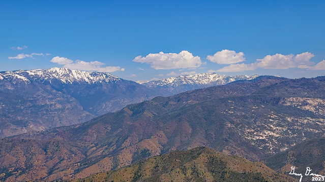
emerald colored hills. But beyond them, we are seeing snow, looking like it starting around 3,000’. This is from a recent storm, so it may melt off quickly.

The road now turns east and we stop at Crabtree for a break time-it is way past elevenses. I devour a Clif bar; Sherri has an Access bar. Three bicyclists pass us-of course we chit-chat with them (Sherri might say it was more of a chinwag on my part. At least it could be a step up from pontificating.) They may be reaching their limits on hill climbing as this is their first outing.


Delilah Lookout from Davis Road
Even though this is our first hike of the season, we will not be stopping here. I figure another hour and a half until we reach my turn-around time. This part of the road, we start rising up really good. But the previous couple of miles I think has loosened my muscles so we can even talk a bit while doing this climb. Another bicyclist passes us-we see him a short ways up chatting to the other three bicyclists. He will pass us again later on.


Davis Flat
One benefit about climbing is that those snow covered mountains are even clearer to see. Even around the Converse Mtn area-not sure if we see the mountain or not-is showing, inviting us to come back and snowshoe, but that is another day.

We now change to the Davis Creek drainage-definitely a smaller creek than Mill Flat Creek. Still there is beauty there. The creek is far beneath us allowing for us to get a good view to the north. Even though we go up pretty good, the creek rises faster. We go around a hill while the creek goes another way. 


Whose Pants?
When we meet up again, the creek is at our level. But there is something else which I start looking for: Delilah Lookout and I found it! Today it seems a lot clearer than when I have seen it before from this road. Also I know that we are close to Davis Flat.


This is good, because I really would like to sit, eat and rest. You can probably guess why. We cross Davis Creek and find the rocks we are familiar with. Time to enjoy lunch, which we do. As we look around us, there is a pair of jeans neatly laid out. The mystery, where are the legs which went into these pants? I do wander to look at the old mine and the shack which we have seen there before.


Rose and Sherri walking the road
It is 2:00pm and now it is time to head back, I am a bit stiff, but as I start walking, the stiffness works out. I fall back as I stop and examine things and even try taking a few pictures. Even with it being easier going down, I fall behind Rose and Sherri. That is OK as I enjoy my time of quiet. With my hiking I enjoy time of friendship, being among those whom I care for. But I also enjoy walking through beauty with my own thoughts and ponderings. On this hike I am getting both-I am blessed. By the way, my thoughts are not great, just enjoying.


Gary in search of a newt


The bike who passed us earlier comes down. We chat for a few minutes. He made it to the approach to Goat Saddle before going through snow got to him. That is a pretty good journey up-about a 2,000’ climb. He goes on and I catch up to Rose and Sherri at Crabtree.

On our final 2+ miles, it is time for some wildlife. No not that kind. First we see a Sierra Newt. This time living. We have seen several dehydrated and squashed-not sure which happened first. Always fun to see them. Then a large bird is circling overhead. It might be an eagle. Or it could be a raven. To me it could be either. An eagle sounds so much better. Then another newt. When I get up from my picture taking, my shovel easily slides down between my underwear and skin. You do not know how thrilling that can be.

We end up at the car with it still being light, around 4:25. We say goodbye to Rose and head off with her following. It has been a good day, tiring though. When we get home after 6:30, Sherri goes out and gets what is becoming our traditional after hike meal, Habit Burger. When I lay down for a few minutes, the next thing I know, Sherri is waking me up to go to bed. I guess I really was tired.


 Extra Photo's

Mill Flat Creek


Davis Road a bit lower at start

Looking north across the Kings

Flowers at Gary's "Disappointment Creek"

Looking towards Converse Mountain

California Golden Poppies

Poppies on a hillside

Flower Photographers


Hills of green

Hillside earth strata

Entrance of Davis Mine

Shack at Davis Flat

Delilah Lookout

Top of where Delilah Lookout sits
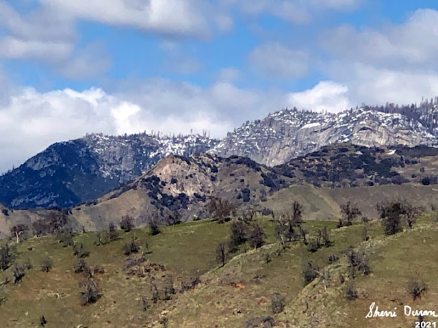
Patterson Bluffs

 Animals

Newts


Eagle or Raven


Flowers and Plants


Lupine

Phlox

Wood Fern-down a canyon and across Davis Creek


Mountain Monkey Flower

Fern


California Golden Poppy


Redbud


Liveforever


Henderson Shooting Star


Baby Blue Eyes