Showing posts with label Nevada Falls. Show all posts

Monday, August 8, 2016

August 8, 2016 - Little Yosemite Valley


Title: August 8, 2016 - Little Yosemite Valley
Hike Info : Description : Trail Lessons : Background : Menu : Extra Photo's : Animals 


Trail head: Illilouette Creek
Hike Info:
Type:  Backpacking
Trail:John Muir Trail
Destination: Little Yosemite valley
Actual Destination: Sunrise Creek
Distance:  5.61 miles 1
Start Time: 9:22
End Time:  4:35  
Travel Time:  7:13 (0.74 mph)
Moving Time:  4:19 (1.30 mph)
Elevation Rise: 1,179'
Maximum Elevation: 6,844' 

 1Usually I figure anything less than a half a mile an hour is GPS error. But because we were going through brush, I lowered that threshold down to a tenth of a mile per hour.

Description:
Today's start is a quote from Tolkein's The Lord of the Rings:  "Short cuts makes long delays." 2 This is where Frodo tried to elude the Black Rider and take off across a bog. Our route did not include a bog, but a good amount of brush. On the other hand, it could also be a title of a book which I will never write: My Life in Buck Brush. As if this walk today does not have enough titles, I could christen it "The Cranberry Girls".

Rose breaking camp
Got up at 6:30. It is was between 30 to and 35 degrees. It was a cold last night. I kept warm enough until I would roll over. Then I would need to warm up the spot which had been on underneath me. But Sherri had difficulty sleeping last night so I suspect tonight we will have a tent. Apparently we were not the only ones who felt a bit cool as when I grab my clothes, a lizard bolted out from there, wondering why in the world are we waking up when it so cold.

As it turns out today will be a turning point in our JMT adventure. If we can make it at least to Sunrise Creek, near the Clouds Rest trail junction, then we should be in good shape to reach Sunrise Meadows tomorrow. I am hoping to make it beyond that, maybe to the upper part of Sunrise Creek.

We did not get started until 9:20. Since the trail is only about a third of a mile above us with a climbable slope-maybe 300' to go up. The trail would take us about a mile with 500' of climbing. Sounded like a good bet even though there was brush, we could find a path through it. And for awhile this was a good strategy. But with about 50 yards of brush in front of us, we could no longer find a way around and had to go through. The manzanita was not too bad, but the buckbrush came up to about my chest. Poor Rose had it at head level. At one point looking back, I see a sea of green manzanita with Sherri and Rose just floating in it looking like the guys in the Ocean Spray cranberry commercials of a few years ago.

The Cranberry Girls

So the "short cut" cost us about an hour and a half and took a lot of our energy. By the time we break through the brush, it is past 11 and we are only a third of a mile from our camp. In retrospect, this may have been the central event of our trip.

Once we are on the trail, I take my rear position and following both Sherri and Rose. We walk pretty good. But it is hot and we are on an exposed part of the trail. By the time we reach the top of the rise, 600' above our campsite and about 2 1/2 miles travel, we are ready for lunch, even though there is no water, we make due.

Rose with Clouds Rest before her


Sherri and Half Dome
There is something refreshing about trail junctions. Maybe it is because of the signs telling us where we have been or where we are going. More than likely it is also  means a marking of a passage. In this case, we meet the horse trail coming in from the upper part of Illilouette Creek, which is nothing really big. But a little ways further we hit the Panorama Trail. Here we wonder, has Kate and Sonya already been by here? Have we been that long in getting here? On the one hand, with the heat and exposure, we really want them to be past the real hot part. On the other hand, it would be somewhat deflating to know that they just started out this morning and have already passed us. See what I mean about trail junctions marking passages?

Grizzly Peak
Liberty Cap
The good part is because of the openness, we are able to have some really good views. Half Dome does loom in front of us, along with its little sibling, Liberty Cap. Clouds Rest soars majestically along a far ridge and Mt Starr King is at our side. Below us towards Yosemite Valley is Grizzle Peak. I love views like this.

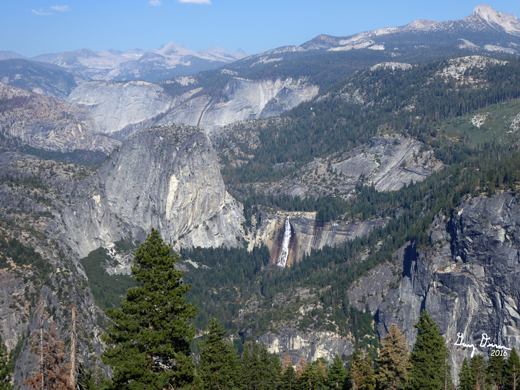
And now that we have lost all of the elevation we climbed up this morning and more, we get to Nevada Falls.  It is time for a pee (not over the Falls) and water break, along with shade from the hot sun. I rest in the shade on the south side of the river while Sherri and Rose go off for their business. Earlier Sherri had talked with some musicians who travel the parks playing their music. I talk a bit more with them-never learn what their names are or where they are from-just enjoying the chit-chat as I sit against my rock.

But the afternoon is progressing and we are not. So off we go. The stretch from Nevada Falls to Little Yosemite Valley starts with a bit of a climb, about 250' as it goes over a shoulder of Liberty Cap. What makes this a particularly wicked trudge is the heat, openness and what you have done just to get to this point. When we come down, I sense that this has just about done us in. So I take off, hoping to get a resting place in Little Yosemite Valley, find Kate and Sonya, and be able to come back and grab a pack. I only succeed on the first task. After wandering around the camp area, I drop my pack and start to go back when Rose and Sherri come up the trail.

We set up camp and I go down to the Merced to draw water. And there I see a couple of blondes-Sonya and Kate. They are flabbergasted to see me and wonder what is going on. I just say that Rose and Sherri are close to their camp and I am drawing water. While we are starting to put together our camp, we discover we are squatters on someone's camp and start to move when they come back. No problem-this is sort of a everybody-loves-everybody-else camp. We end up staying with Kate and Sonya.

As you might have guessed, we are staying the night here rather than trying to make Sunrise Creek, about 1,300' above us. We are beat. After eating and talking for a little while, it is time for bed, or should I say for the bag. And yes Sherri did put up a tent.

Before I end this post, one thing which I have been contemplating is that experience itself does not make you better, but learning from experience does.  So the big question is, what did I learn today?
  • First, just because a map shows a direct route does not mean that it is.
  • Second, scout out your route. Maybe I could have gone around the area if I had been more alert.
  • Third, remember the rule of thumb: a mile of cross country is about the same as three miles of trail.


Trail Lesson:
  • Short cuts may not be the shortest or quickest ways-either on the trail or in life.
  • Experience itself does not make you better, but learning from experience does


Background
 2From Tolkein's Lord of the Rings, Chp 4, A Short Cut to Mushrooms

Menu

 Breakfast Lunch Dinner Snacks
Oatmeal and add-ins, such as dried peaches, strawberries, nuts, granola. Tang. Ritz Crackers, Tortillas, Peanut Butter, Nutella Mountain House Lasagna Clif Bar, GORP, Propel, CytoMax, Scrytch, Coffee Candy, Jelly Belly


Extra Photo's


Gary with his full pack


Half Dome


Half Dome

Animals

Mangy coyote

Same coyote, different view


Sunday, August 7, 2016

August 7, 2016 - Illilouette Creek


Title: August 7, 2016 - Illilouette Creek
Hike Info : DescriptionMenu : Extra Pictures 


Trail head: Glacier Point
Hike Info:
Type:  Backpacking
Trail:Illilouete Creek
Destination: Illilouete Creek
Distance:  3.34 miles1
Start Time: 4:26
End Time:   6:42 
Travel Time:  2.15 (1.49 mph)
Moving Time:  1:48 (1.86 mph)
Elevation Rise:  286'
Maximum Elevation:7,165'
 1I thought I had lost the tracks for my Garmin Foretex 401-I had not. But in digging around to see if I could find replacement information, I found a very promising web site called Sierra Mapper. With Sierra Mapper you can put in two points along a trail and voila! lots of trail information appears, including distances, maps and elevation profile. With Sierra Mapper, the distance it calculates is  3.23 miles and an elevation rise of 125'.

Description:
As Dylan once sang, it's been a long time a-coming. From when Rose and Shawn proposed going on the Trail right after Sherri and I got off of it to us inching towards saying yes. Then Shawn needed to drop out of this journey but Sonya, Kate and Kim got added on. During the last 7 months. its been one of the top things on Sherri and mine mind, and today it comes to life!

Yesterday Rose, Sonya and I went to Wawona to see if we could rearrange our permits, but so far it is the best we can do. But Rose, Kim, Sherri and I will probably come into the trail at Silver lake instead of Parker Pass. The pass after Parker looks scary-that would be Koip Peak Pass.

Am I all packed? I think so. My pack certainly feels like it is. Including food and water, my starting weight is 47 lbs; Sherri's is 26. But it will get heavier when we pick up our restock in Tuolumne.http://gary-summer.blogspot.com/1970/01/place-ca-tuolumne-meadows.html I expect it to be around 55 lbs and Sherri's to 32. Then even heavier at Edison. By the way, my starting weight is 267. I hope to lose 15 lbs before we end this trip.

Sherri and Rose in the Glacier PT parking lot
We are slowly in leaving Fresno. I need to take care of a stack of stuff-mine, my parents and Sherri's cousin Vera. So we get to Rose's house a little after 1:20 o'clock. And take off around 1:30. Jeff, Rose's husband, takes us up to Oakhurst where we get our dinner:  that would be a turkey sandwich.  Rose procures a sandwich from Deli Delicious. Then it is off to Glacier Point, with a brief bathroom stop at Chinquapin.

By this time it is the bit after 4 o'clock and 4:30 by the time we say our farewells to Jeff and get our pictures taken for the trail. The first mile is just an assortment of wonders. We looking over Half DomeNevada and Vernal Falls. Much of the country we will be passing through for the next couple of days is before our eyes. 


Half Dome from Glacier Pt
Rose and Sherri and Liberty Cap


Rose and Sherri and Half Dome
As we go down the trail, the path goes through buck brush, chinquapin, manzanita, and a bush with a heavy soda smell-at one time I knew what the plant was, but I cannot think of it now. This is the same plant we saw last May coming back from Deer Camp-I did not know it then and I still do not.

But I am also living in the memory of the last time I went down this trail-a year ago July. Keirnan had forgotten her id at the start of the JMT hike. I chased after her for a mile-I timed it this time and it really was a mile. Then I got to go up this trail the same mile. But today, it is down the slope.

The trail is all downhill-well, almost all 99 percent of it is down. So we make pretty decent time are packs field a bit heavy because we are not quite used to them yet.  When we hit Illilouette Creak, we feel like it is time to to make camp. But we still travel about a half mile to find a suitable, unused campsite. A couple of other places already have people. We see a camp across the way across the creek and with an easy creek crossing. Illilouette is not high so we an easier crossing than what I have feared.

Crossing the Illilouette
The campsite site looks nice from across the creek and its  even somewhat flat. When we examine it, there is some picking and choosing of spots as there is a bit of a slope. Sherri and I decide to sleep under the stars since it seems a bit warm, while Rose puts up her tent.

We have our dinner-on our part a turkey sandwich-and then make ready for bed as it is starting to get dark. We are moving a bit slow,  but there's no need to rush. By the time which we get to bed it's around 9 o'clock and the stars are coming out. Mars is hanging there just really wonderful looking, along with the Milky Way being just amazing.

Illilouette Creek


Menu
 Breakfast Lunch Dinner Snacks
Granola at home Peanut Butter Sandwich at home Turkey Sandwich from Pete's Place in Oakhurst, ate at Illilouette Creek Jelly Belly, GORP


Extra Pictures


Illilouette Creek Drainage

Backcountry from Glacier Point
 

Thursday, May 15, 2014

May 15, 2014 - Sub-Dome and back to car


Title: May 15, 2014 - Sub-Dome and back to car
Trail head: Little Yosemite Valley
Hike Info:
Type:  Hiking
Trail:  Half Dome
Destination: Sub-Dome
Distance:  7.10 miles
Start Time:   8:55
End Time:    2:50
Travel Time: 5:54 (1.20 mph)
Moving Time: 3:57 (1.80 mph)
Elevation Rise: 2,259'
Maximum Elevation:  8,100'

Description:

I slept well, albeit the bag seemed a little cold. But that was remedied by putting my socks on. By the time I got up Brian was already pacing about, the sun was shining and the hour hand had already passed by 7. It is a bright and beautiful morning. We decide that hoofing it up towards Half Dome was in our future. Brian is thinking about trying Clouds Rest. So we had our breakfast of oatmeal and toppings, along with Tang, coffee, tea and chocolate before getting to the trail around 9.
Half Dome and Sub Dome
Clouds Rest
By this time Brian had already decided to charge forward to do Clouds Rest. I realized there was no way I would keep up with him, so I decided to adopt the role of chief encourager to Bill and Jerry on our trip toward Half Dome. We realized that we would not make it that far, but would try to go at least as far as the base of Sub Dome. At the Clouds Rest junction, I walked a little ways with Brian, but then turned back around. We did see some scat, which we did not identify, but looking at a book I have, I think it was something like coyote.
Side of Tenaya Canyon courtesy of Bill
Jerry, Bill and I continue on our climb up the ridge leading towards Half Dome. Slowly the Quarter Domes come into view on our right, with the promise of more scenic glory to come. There is the appropriate sounds coming from our lips when we reach the ridge top and see out across Tenaya Creek. Pywiack Cascade takes center stage for his act with Mt Watkins across the way. We see Brian's objective, Clouds Rest in back of the Quarter Domes. Then further back, is the country towards the Tioga Pass Road. So good.
But the trail leads even more upward from here. Fortunately, the scenery only gets better. We stop often to take pictures and enjoy the sight before us. Not only to the north do we see, but towards the south and east. Mt Starr King directly to the south with the Merced River drainage to the east. There is a snow pack back there, but not for long.
Snow Creek courtesy of Bill
As we reach Sub Dome, we do see spots of snow in the shade, but not much. We turn aside and have a snack looking across the Tenaya Creek canyon. Snow Creek Falls is right across the way from us. You can see the trail zig-zagging down, just being glad we are not on it right now, but I our hearts wishing we could be. North Dome and Basket Dome are a pair facing us. It is wonderful to be here.
Tenaya Canyon


Half Dome from the side
I induce Jerry to go a little ways up Sub Dome. The ranger stationed at the bottom says that they are almost done putting up the cable on Half Dome. But we are only interested in seeing a little more of a view above tree level. Climbing up another 150' we get that view. The stairs are rather unnerving, so we do not go very far. But the view is so open to make things worthwhile.
We descend, enjoying the views retreat from  our view. But we savior them as they leave us. I finally find the spring I was looking for on the way up. Another tree had fallen and some rounds had been cut, block it from view. Also, the spring was more mud than bubbly, not nearly as appealing as it had been in previous years. 
View From from Sub-Dome
We also meet two backcountry rangers on a training hike. Ranger Kahn will be north of Tuolumne Meadows along the PCT. I pick her brain about places to go for later on this summer. The other ranger is stationed out of Merced Lake. Fun seeing these rangers up
here.
Clouds Rest from Ridge
We get back to camp close to 3. Lunch is PB, Nutella and crackers, plus leftover goodies. The water filter is almost coming to a stop. Later on when I open it up, it really has a lot of stuff on it. So it is time to replace it. Bill goes to the river and wets his feet and fills his bottle. Brian comes in at 3:15 after successfully conquering Clouds Rest.
Half Dome From Clouds Rest courtesy of Brian


Brian on top of Clouds Rest courtesy of Brian


Trail head: Little Yosemite Valley
Hike Info:
Type:  Backpacking
Trail: John Muir Trail
Destination:  Return back to car
Distance:  5.73 miles
Start Time:   4:04
End Time:    7:03
Travel Time: 2:58 (1.93 mph)
Moving Time: 2:35 (2.22 mph)
Elevation Rise:  326'
Maximum Elevation:  6,237'

Description:
After our semi-morning hike, it is time to return to the car. For the most part, the route is a repeat of our trip up. That is except for about half a mile right at the start. Instead of going by the river, go north and then take the diagonal. Brian and I see our Liberty. Cap path, about half-way on the diagonal, at its high point. Bill and Jerry have zoomed ahead while Brian and I lolly gag in back.
We hit the bridge over Nevada Falls, which confirms our thoughts that more water is flowing down the Merced than yesterday. The turbulence of the waters is mesmerizing, the violence of its rush over the side has a pull, but not an attraction. The rush contrasts with the stillness of the backdrop.
Liberty Cap courtesy of Bill
Jerry, Gary, Bill, Brian
But we need to go on since the hour is getting late and we want to be down before dark. Still Brian and I accosted some out of state folk and explained some of the wonders of Yosemite for about a mile. We even gave them some decent advice about what to do on a limited amount of time when close to Glacier Point. Wonder if they will ever come back to the Golden State? But just to show that I am a serial trail chatterer, I started talking with an English girl. She wanted to know about various parts of the Valley since she only had the next day to move on.
Brian was starting to feel the length of his hike, so he started to speed up. So I hiked with Bill and Jerry the rest of the way down. The car was a welcome sight when we come in around 7. On homeward we went, but nit before stopping at that Mecca of Oakhurst-Todd's! Perfect way to end our hike. Pleasantly content to make it back to Fresno by 10. The shower and bed felt good.

Wednesday, May 14, 2014

May 14, 2014 - Little Yosemite Valley

Title: May 14, 2014 - Little Yosemite Valley
Trail head: Happy Isles
Hike Info:
Type:  Backpacking
Trail: John Muir Trail
Destination: Little Yosemite Valley
Distance: 5.55 miles
Start Time:  11:16
End Time:     3:42
Travel Time: 6:26 (0.86 mph)
Moving Time: 2:55 (1.90 mph)
Elevation Rise: 2,589'
Maximum Elevation: 6,192


Bill
Description:
Got up a bit before 6 and had my quiet time until waking Sherri at 6:15. Then it is meal prep for our breakfast with Brian, Jerry and Bill. Sherri is making waffles for the hikers who arrive at 7. Everybody feels content and we leave Fresno by 7:45. So far a good start. We grab sandwiches at Oakhurst, where Heather waits on us-remember Heather? She is the one who finished cleaning up Sherri's and mine wine mess a month ago. Anyway, off we go to Wawona to pick up our permit and be off. But unfortunately Wawona cannot issue the permit-they are not fully open yet-Heidi is not here. So off we go to Yosemite Valley where we quickly get our permit from the Wilderness Office. 
But the end story on this, we do not get walking until 11:00-a lot later than I was hoping for.  The sun is already warming the Valley, but out walk from the backpackers parking lot to Happy Isles is under the shade of trees, which keeps down the heat and makes for easier walking. The first mile gets us to the foot bridge below Vernal Falls. This is a well known paved path for all of us. We are in pretty good shape.
Lunch Break courtesy of Brian
Half Dome, Mt Broderick, Liberty Cap


Here we start climbing up the John Muir Trail. None of us are interested in going up the Mist Trail, particularly with packs on. But the JMT has its scenic advantages as well. For one, as you climb, you get to enjoy the same scenes from different perspectives. Such as Yosemite Falls framed through trees or both Vernal and Nevada Falls  from side views with Half Dome, Liberty Cap and Mount Broderick all looking at you. Plus, the climb up is gentler, if you can call a 2,000' climb gentle. So it is at least easier on the body.
Nevada Falls
Top of Nevada Falls
At Clark's Point, we stop for our lunch. It is hot, but we have been mostly shaded. Most of our climb is out of the way. Still there is a two mile push to the top of Nevada Falls. Just about as you despair of reaching the top, you notice that you are almost level with Nevada. Then a gentle rise brings you to the cooling drip of the cliff where you enjoy the best view of Nevada which I have seen. As we pass the junction with the Panorama Trail, we drop down to the top of the Falls and enjoy a few moments of rest and energy bars under the shade of a tree.
Entering Little Yosemite Valley
Merced River
Now for a short 200' rise up past the junction of the Mist Trail and we are in Little Yosemite Valley. Brian wonders where the path up Liberty Cap is? We speculate about every little opening in the manzanita. But none of these are it. The comment is made that that is not something to do in shorts. The trail follows close to the Merced River, giving us both cooling to the skin and refreshment to the eyes. Before long, we cut off to the campground area. Our camp spot is #16.


Camp Courtesy of Brian
 The other men pitch their tents, but since the weather is good and the mosquito's are not out, I decided to sleep under the stars. It is still early, around 4:30, so we go to the beach to enjoy the cold Merced waters and the warmth of the sun. I had scooped up some water in my Base Camp filter, when it was noticed the filter was leaking. The "O" ring had gotten stretched and no long fit nicely. But we still got filtered water, but just several more trips to the river. After the last of our Subway sandwiches, Jerry breaks out the cards and we play hearts, well past when we should have. At 10, fold up and hit the sleeping bags and watch the almost full moon come out before going to sleep.