Showing posts with label Indian Canyon. Show all posts

Wednesday, May 5, 2021

May 5, 2021 - Middle Yosemite Valley


May 5, 2021 - Middle Yosemite Valley
Hike Info : DescriptionExtra Photo's : Animals : Flowers and Plants
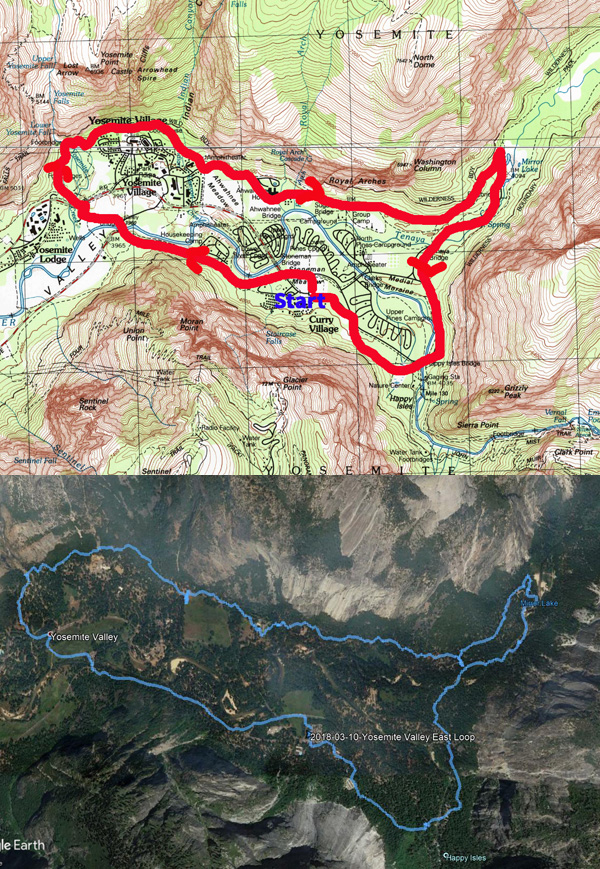
 
Hike Info:
Type: Hiking
Trail:  Valley Loop
Destination:
Actual Destination:
Distance: 8.53 miles 1
Start Time: 9:51
End Time:  3:59
Travel Time: 6:07  (1.39 mph)
Moving Time:  4:34  (1.87 mph)
Elevation Rise: 568 '
Descent: 585‘
Maximum Elevation: 4,060'  

GPS Tracks

  1There was a wide range of mileage readings. This particular one is from our Garmin 60CSX. My Garmin Foretrex401 9.94. While Rose’s InReach was above 10 miles. The 8.53 is more in line with the expected mileage. The Valley walls can sometimes play havoc with GPS signals.

Description:

Rose and Sherri examining a climber's van


It has been a couple of weeks since we have hiked with The Sisterhood. First Betty had a commitment. Then Carol had a hard week at work. So she begged out. So Rose is stuck with Sherri and I.

It has a potential of being a long day, so we get off to an earlier start than usual. We had planned on leaving Fresno at 7:15, but got off a few minutes late. We will meet Rose at Chinquapin. But first, we need to get through a couple of construction sites, but we get to Chinquapin only five to ten minutes after Rose. We continue onto the Valley. I had suggested that we park at the lower end of the Valley so we walk downhill on the way back.

El  Capitan and the Perced
We found a place to park right before the El Capitan Road on the south side of the Valley. We will go clockwise on the theory that with it being predicted to be warm today, we should be a bit more in the shadows in the afternoon.

We get ready to go just before 10. We head north along El Capitan Road. Just before the bridge, we see a climber’s van. How do we know that it belongs to a climber? There are routes drawn on the side of the van up El Capitan. We stop and look with interest.

Dead Tree Disguised as a Rope

But as much as we want to wonder about the owner, we have miles to go. Off we go. We turn east along the north side of the Merced. We move pretty good. After a short way, we met a couple. We talk and wonder if there are climbers on El Capitan. It does not look like it. I think I see a rope hanging from an overhang-Rose points out that it is a dead tree. Imagine a dead tree disguising itself as rope.

A short distance later, we hit the Valley Loop Trail and continue east. The trail follows the road, but then it leaves the road, following the river. But there is a need for some personal necessity. The El Capitan Picnic Area is a short ways ahead, so we continue to follow the road.

Gary meets a friend
 

The picnic area was a bit further away than imagined in my mind. The principal attraction of the picnic area is the outhouse, but not the only attraction. As we leave we see a lone redbud, but looking pretty nice. Looking around, there is El Capitan and Sentinel Falls, and of course, all of Yosemite Valley.

Sentinel Falls
We find a path back to the Valley Loop and continue on. The path is still pretty level. We come to a parking area and see a few more people. A bit beyond is a tree which has split--I call it the Tree of Doom. We need to walk right under it. I approach a bit apprehensive and proceed to scurry below it. Rose and Sherri come after me with none of that apprehension. A short way further we cross the Northside Road.

Now we pass by the site of the old Indian village. There is construction going on. But there is also a sign talking about an event taking place. We go past the SAR village and into a deserted Camp 4. We decide this is a better place to have lunch rather than going on to the

Tree of Doom-Rose and Sherri walkign
Yosemite Falls picnic area. Lunch is our normal stuff. But the bathrooms are not open, so we continue on.

It is a short walk to the Falls. They are beautiful like always. Maybe not as full as it should be in mid-Spring, still a thing of beauty. Also it is not too crowded, at least by Yosemite standards. Even with the decreased amount of water coming down, there is a nice wind being generated. Evidently it is enough of a breeze that if a person is not attentive, they may lose her hat. I do grab mine, but Sherri is not as quick. Her hat goes over the bridge onto the rocks before-at least not into the creek. Then yours truly, your faithful narrator, a chance to play super-hero. So he does an old man type of waddle around and down and picks up the hat. He gets a hero welcome.

Lower Yosemite Falls

The Dogwood patrol


We continued on going the long way back to the Falls bathrooms.Maybe I should say this was the scenic route. Usually not as many people, but today there is a fair number of people. There is a slight mix up at the bathroom-we were looking for each other and not finding us. Eventually we hook up and are off.


Gary Rescuing a hat


There is a decision that we should do the shorter route back to the car. So we cut through the Yosemite Lodge area. Even here we are blessed. I think we come across the epitome of what a dogwood should look like-unfortunately our pictures are not of the same quality as this tree. It seems like everywhere we look there is a dogwood gracing our vision.

And there is a fireplug. And what is one of those things good for?


Wow! Such a nice shaped dogwood
The next point of interest is the Swinging Bridge. Here we meet a guy who wants to know about some of the floods as well as landmarks in the Valley, also where is it-we are standing on it. But this is not the original which got wiped out during floods. I spend some time giving my impression of a tour interpreter. Seems to impress the guy enough. But I do think this bridge and a bit of the area gives one of the better views of the Valley. Half Dome and Clouds Rest, not to mention North Dome, Washington Column, and Glacier Point are all in view. Looking the other way, El Cap and Cathedral Rocks all dominate view to the west. What a place! I like to think that God created this place to perfection. It is up to us not to spoil it.


Fireplug


View From Swinging Bridge
 

Sherri and Rose spot a set of falls to the side of Indian Canyon. I do not know what creek that it-I do not think it is Indian Creek as that runs down the canyon. Later when I get home and look at a topo map, I figure out that it is Lehamite Creek which has a pretty good size falls, even if it is ephemeral.

The south side of the Valley Loop Trail greets us. We know that we are on the home stretch-even though we know we have a ways to go. I am beginning to feel my legs want an end soon. I do not hike as well in warm temperatures and it is over 800 today. My theory about walking on the south side is not true, at least during the Spring, and probably the Fall. Still there are miles left in them.

Crossing Sentinel Creek


We come to the Four Mile Trail, and pass by it. Then it is up and down some small ridges-this does not do much for my legs. And then I hear what looks like a chainsaw. What is one doing in the Valley? A few minutes later, we spot a fire crew working on bringing down some of the dead trees. We briefly talked with the leader and he said it was OK to go through-the guys (and gal) will pause when we are near. 


Valley Loop on the Southside


A ways later we come across a couple who we talked with earlier (I do not recognize them, but they do us.) They have also picked up a person as well. We tell them about the crew ahead. They seem to have enjoyed the trail as much as us-always a good thing.

And now we come to the trail junction which leads us back to the El Capitan Road. And then a short walk back to the car! Glad to get back. After getting our hiking stuff stowed, The three of us talk-seems like we do not want to part. After 45 minutes we do seperate, going our own ways. We stop in Oakhurst for a bite to eat before heading home. Another good day.


Extra Photo's
Yosemite Falls

Where are the people?

El Capitan

El Capitan

Gary with Rose and Sherri looking at Manzanita

Yosemite Falls

Sentinel Falls

Looking east up the Merced

Flowers on a rock

Yosemite Falls-Rose and Gary

Middle Yosemite Falls

Dogwood

Dogwood and Sentinel Point

Lower Yosemite Falls

Dogwood and Yosemite Falls

Gary and the Falls


Sherri and Rose admiring the view

Rose crossing Sentinel Creek

Gary and the Gunsight

El Capitan

Yosemite Falls

Animals

Mallard


Flowers and Plants

Manzanita


Dogwood


Redbud

Saturday, March 10, 2018

March 10, 2018 - Yosemite Valley East Loop


Title: March 10, 2018 - Yosemite Valley East Loop
Hike Info : Description : Trail Lessons : Background : Extra Photo's 
Hike Info:
Type: Hiking
Trail: Valley Loop Trail
Destination: Loop
Distance:  8.74 miles
Start Time: 9:37
End Time:  3:01
Travel Time:   5:24 (1.62 mph)
Moving Time:  3:41 (2.37 mph)
Elevation Rise:  958'1 
Descent: 871‘
Maximum Elevation: 4,241'

 
1I have some doubts about these figures. On a FitBit, one person recorded 650’
 of climb, another recorded 550’ on a SmartPhone tracking device.

Yosemite Falls from Stoneman Meadow
Description:
This is a Meetup hike, but with the idea which Sherri and I are getting ready to walk the half marathon at the California Classic. The idea is that each week leading up to the half marathon on April 8th, we will go on longer and faster hikes. So the schedule is to do the loop around the eastern Yosemite Valley.
But, the week before, the weather forecast ranged from rain to snow to sun and back to rain. So there is some concern about the weather for the hike. On the morning the of the hike? The forecast is for a good amount of rain with a light rain starting at 11am.
Sherri, Oz and Half Dome
We gather at 6:45 five of us, waiting for a person who never shows. We briefly stop in Oakhurst for coffee and then hurry on, hoping to beat the rain. There is another brief bathroom stop at Bridalveil Falls. Going along the south side of the Valley, we see snow, lots of snow. This affects my thinking of how to do the hike-rethink about going around Mirror Lake and going clockwise around the loop instead of the traditional counter-clockwise.


Oz and Half Dome At Sentinel Bridge


We get to Camp Curry at 9:30 and start walking soon afterwards. We quickly get the benefits of going clockwise as we get good views of Half Dome and Yosemite Falls-Stoneman Meadow has such good views. Then we pass by the employee housing, The first mile or so is paved for bicycles. When we get to Sentinel Bridge, we cut over towards Yosemite Falls. But not before stopping at this huge granite boulder. What is so special about the boulder? There are a couple of iron rings planted in here. The question is, why? But we also talk a bit about the old village which used to be around here.


Map of Old Yosemite Village from  Eldon Grupp

Yosemite Falls


Then it is time to cross Cook’s Meadow on the way to Yosemite Falls. Of course, I cannot help but to talk a bit about the hotel which used to be here. A sign already lets the group know about the use of the meadow. Then onwards to the Falls, with a brief stop at the bathrooms. When we do go over Yosemite Creek Bridge, it is time for another talk explaining that there are eight (now seven) historic bridges in Yosemite Valley on the National Historic Landmark Registry.
Gary, the Tour Guide
Lost Arrow
Yosemite Falls does not disappoint us. Sometimes the falls are running so strong, you cannot walk across the bridge because of the spray; other times you think that NPS may have forgotten to pay their water bill. But today, the Falls have enough water to go over and create some pretty good eye candy. There is an ice cone at the bottom of the upper falls, but none at the lower. From the viewing area, we can also see Lost Arrow. Here I go into an abbreviated, unpoetic version of the story of Lost Arrow. After looking for a few minutes, we continue on the northern part of the Valley Loop Trail.

This part of the loop goes about a hundred feet above the current Yosemite Visitor Center and along the northern wall. We meet a couple from Visalia along this section, exchanging greetings. While in most places, there are too many trees for a good view-strange complaint isn’t it-we do get glimpses of the Valley floor. Still it is enjoyable, even though I huff and puff a bit. After the stretch, we come down the trail into the Ahwahnee Meadow area. There is all the luxury you would want on a hike and for lunch: picnic tables and flush toilets. You got to admit, Life is Good!
After we finish lunch-mine the traditional sandwich of the Duran’s, we continue on. Nobody was interested in going into the Ahwahnee Hotel, so we continue on towards Mirror Lake. The tricklets we see on the Royal Arches combines up into a nice little creek which we are thankful for stones placed strategically along the trail for a dry crossing. Earlier I had talked about Indian Canyon and the escape routes which the Native Americans had to escape the Army. The other place is the Indian Caves close to the foot of Washington Column.
Mirror Lake Ice

Mt Watkins and Ahwiyah Pt

Ahwiyah Pt and Half Dome


After that, it is, easy walking until we reach the bathroom at the foot of the Mirror Lake grade. We stop for a break here. A group from Notre Dame comes by and we talk with them for a while. They are part of a group going on to the Bay Area to study entrepreneurialism.
We say goodbye to them and continue on the stable trail to Mirror Lake. I do a bit more huffing and puffing. Because the area is pretty sheltered, snow has stayed on the trail, which in itself, is not too bad. But since we are going up and down a small ridge, there are these rock steps which the packed snow makes a bit more dicey. But we all get over it and drop into Mirror Lake.
Now for decision time. Do we go around Mirror Lake? Or just return down the road and meet the trail at the bottom? After consideration, we felt we were being fortunate with the rain not falling, why chance being stuck 45 minutes away from any shelter? We meet the Notre Dame group again and get a chance to talk with a couple from the group. We share different parks which we have been too. Acadia National Park gets added to the bucket list.

So down the road we go. But not before taking many pictures of places like Mt Watkins and Half Dome reflecting in the Lake. Some beautiful reflections of the walls of Tenaya Canyon. The trail and then road down is non-eventful. When we get to Tenaya Creek Bridge, we leave the road and rejoin the Valley Loop Trail. This takes us just off the road on the most eastern side of the Valley. Few people use this trail, even though we are passed by a trail runner. Soon we come to Happy Isles, and its bridge. We take the last bathroom break of the day before heading on the backside of the area. There is a trail which goes to the backpacker’s parking lot. This is all covered with snow, so it makes a bit of a slower pace. Also we feel a few drops as we go along. Then it is off to our car.
Hidden Half Dome
We get back to the car about 3:40 and take a few minutes to change out and get ourselves all situated for the drive back. We stop in Wawona for the bathrooms as well as phoning in our pizza order to Sugar Pine pizza in Oakhurst. Good eats. The conversation is a bit muted, I think we are all tired, and just want to enjoy being with each other. By the time we get back to Fresno, it is about 6pm. Another one of those good days in Yosemite.


Trail Lesson: 
Leadership in a hike consists of convincing people that where you are taking them is where they want to go. (Actually, what was said was a lot better, but cannot think of what was said then.)

Background
Historical Bridges of Yosemite Valley
  • Yosemite Creek Bridge 
  • Ahwahnee Bridge 
  • Clark Bridge
  • Pohono Bridge
  • Sugar Pine Bridge
  • Tenaya Creek Bridge
  • Happy Isles Bridge
  • Stoneman Bridge


Extra Photo's

Lower Yosemite Falls

Yosemite Falls From Cooks Meadow

Yosemite Falls

Mt Watkins and Mirror Lake

Gary in thought