Title: July 26, 2015 - Lassen Peak and Cold Boiling Lake
John and Cathey need to figure out a better sleep schedule. They are sleeping a cabin about a half an hour down the road, so they must have gotten up even earlier than my 5:15 time. Sherri and I have a couple hard boiled eggs given to us by Sharon M. Much faster and less noisy than the oatmeal we were planning on having.

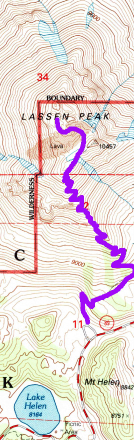
Hike Info:
Type: Hiking
Trail: Lassen Peak
Destination: Lassen Peak
Distance: 5 miles 1
Start Time: 6:40am
End Time: noon
Elevation Rise: 2,000'
Maximum Elevation:
1My GPS was low on batteries. The mileage and elevations are based upon the standard information for the Lassen Peak Trail.Right at 6 they come by the campground and we drive up to the trail head. which is another half an hour away. It is much cooler and winder this morning than yesterday. Of course, we are starting 2+ hours earlier. Still, I start off with a T-shirt, I have my windbreaker in my pack. But I suspect I will be sweating soon enough.
 |
| Cathey and Sherri at start |
 |
| John and Lassen Peak |
We go up and John and I talk a lot on the way up. John plays a conversation game with me. As we reach each switchback, we talk. Then he will say, and there is one more thing, which he will tell me at the next turn. Certainly makes the trail go faster, and keeps up the interest. John's stories, though, does not need too many devices to maintain interest.
We make it to the end of the NPS trail on top of Lassen. When I describe the "trail" to the high peaks of Lassen, it was decided we have had a good hike, why spoil it? So we rest, take pictures, and try to stay out of the cold by hiding behind a rock outcropping. Then it is time to do the descent.
We were within the first ten people on top of Lassen. But now starting to come down, there are hoards of people.. Guess it is a good thing to be early-John and Cathey may be wise in this matter, even though I sort of would have liked to have been in the sleeping bag a little bit longer.
The good thing about going down is that all of the sights we had coming up, we can now enjoy. Brokeoff Mtn shows a bit of grace in front of us; Lake Helen with its cool blue waters looms larger as we come down. Even though the trail is steep, there is something refreshing about this descent this morning.
When we get down, we say our goodbye's to John and Cathey. It has been awhile since I have hiked with them and it was good being with them. They are heading to Stockton to be with their daughter, but we are going back up the road to look for a hike.
 |
| Cathey and Sherri at Top |
The good thing about going down is that all of the sights we had coming up, we can now enjoy. Brokeoff Mtn shows a bit of grace in front of us; Lake Helen with its cool blue waters looms larger as we come down. Even though the trail is steep, there is something refreshing about this descent this morning.
When we get down, we say our goodbye's to John and Cathey. It has been awhile since I have hiked with them and it was good being with them. They are heading to Stockton to be with their daughter, but we are going back up the road to look for a hike.
 |
| Wise Ones (or Guys) |
 |
| Sherri on remains of a glacier |
 |
| John and Brokeoff Mountain |
 |
| On way down |
 |
| Brokeoff Mountain |

Trail head: Kings Creek Picnic Area

Type: Hiking
Trail: Cold Boiling Lake Trail
Destination: Cold Boiling Lake
Actual Destination: Crumbaugh Lake
Distance: 2.58 miles 2
Start Time:
End Time:
Travel Time: ( mph)
Moving Time: 1:05 ( mph)
Elevation Rise: 200'
Maximum Elevation: 7,200'
2The mileage is based upon trackings by PDF Maps.
After leaving John and Cathey, we went back up the road looking for a lunch place. Found the picnic area at Kings Creek. So we grabbed a table and had our peanut butter, Nutella, and Ritz crackers. Afterwards, I take a quick nap. I cannot say I felt terribly more refreshed and definitely not energetic-actually Sherri looks more energetic than I am. But I would also like to explore the area.
So since we are at this area and Kate and gang were talking about Cold Boiling Lake, we might at well see it for ourselves. We move the car so that someone else can park in the picnic area and then start out. But a few steps later someone asks a few questions about the area, and of course, when has a lack of knowledge ever stopped me from answering? After giving the lady some wonderful advice, I am sure, we go ahead and start on. The trail is not too bad and Sherri and I enjoy the walk over to Cold Boiling Lake.
The thing about this lake is not so much that it is boiling, but more has a flatulence problem. There is a lot of gasses escaping through the water causing the bubbling effect. Also at one time this lake must have been a lot larger and the gasses would have been coming through the lake. But now there are more ponds or puddles surrounded by grass getting gassed-sorry, just could not resist.
We pick a nice place to watch some ducks on the lake, while others go by. It is quite enjoyable just laying by the lake, relaxing. There is one group of about 15 going on to Bumpass Hell. So after a quick discussion, we decide to go the other direction: Crumbaugh Lake.
The trail down is a moderate, but short downhill. We pass by some meadows and enjoy the freshness of them before they turn brown for the summer. A couple of people come up the trail, but not many. When we get to the, we have it all to ourselves.
For so little effort, we have hiked harder for worse places. The grasses blowing in the wind, corn lilies framing the lake and you through in a mountain background, you have a nice place to stop and enjoy a snack. And that is what we did, along with just lie down for awhile.
So since we are at this area and Kate and gang were talking about Cold Boiling Lake, we might at well see it for ourselves. We move the car so that someone else can park in the picnic area and then start out. But a few steps later someone asks a few questions about the area, and of course, when has a lack of knowledge ever stopped me from answering? After giving the lady some wonderful advice, I am sure, we go ahead and start on. The trail is not too bad and Sherri and I enjoy the walk over to Cold Boiling Lake.
 |
| Bubbling water in a grassy pomd |
 |
| Cold Boiling Lake |
 |
| Crumbaugh Lake |
The trail down is a moderate, but short downhill. We pass by some meadows and enjoy the freshness of them before they turn brown for the summer. A couple of people come up the trail, but not many. When we get to the, we have it all to ourselves.
For so little effort, we have hiked harder for worse places. The grasses blowing in the wind, corn lilies framing the lake and you through in a mountain background, you have a nice place to stop and enjoy a snack. And that is what we did, along with just lie down for awhile.
 |
| Corn lily and lake |
 |
| Grass, wind and lake |
The trip back is just a retreating along the same trail. Except it is not the same. We get to be treated to the scene of a cinnamon-blonde bear scrounging along a log, looking for food. When he notices us, he wanders away, but we see him again just on the other side of the tree. At that point, even though we are a ways away, he tires of us and runs away.
 |
| Brown Bear Friend |
After dinner, we sit/stand around and talk for a while I notice at sunset that there are clouds gathering and put out the alert that it may rain tonight. So we batten down the tents, clean up the camp and hit the bags. Just after I get settled in, it starts to rain. It rained pretty good for about 20 minutes and then stopped-just enough to make sure I was not lying.