
Title: November 13, 2021 – Movie Drive, Bishop and Bristlecone Pine

 |
| Car route |

Hike Info:
Type: Hiking : Car
Trail: Mobius Arch Loop Trail
Destination: Loop-arch
Distance: 0.62 miles 1
Elevation Rise: 129'
Descent: 126‘
Maximum Elevation: 4,689'


Hike Info:
Type: Hiking : Car
Trail head: Bristlecone Pine Visitor Center
Destination: Loop
Distance: 0.95miles 1
Elevation Rise: 366'
Descent: 349‘
Maximum Elevation: 10,357'
1Hike data plotted from Google Earth. Also GPS tracks are plotted with Google Earth

 |
| Lone Pine Peak |
Got up at 7:30 after laying around for an hour. Last night I put out an alternative to going to Death Valley today. The reason being Sherri had wondered a few days ago if we would be able to get a campsite at Texas Springs. After our breakfast at Best Western-I had two pancakes and a bowl of cereal-we discussed staying or going. In this case, it is an approach-approach conflict. Staying won. Sherri contacted the front desk and we can stay in our room.
 |
| No Name Rock? I call it Walrus Rock. Mt Whitney in background |
We did not need to pack up, not that we have unloaded much-this is Sherri’s system of only bringing in a minimal amount of stuff. No suitcases, just the clothes to change into and a couple bags of medicine and toiletries. Of course, I have my bag of electronics-where would I be without them?
Gary on Arches Loop
Anyway,
we take off about 10 and head south a couple of miles to the Eastern
Sierra Visitor Center. We came here a couple of years ago and it was
a good place to start an adventure. Today was no different. We looked
over the exhibits, then bought a few trinkets. We asked Davis, a
ranger on duty about what would he do with the remainder of the day
to see and experience the area. He listed out several things-the
usual tourist stuff:

- Alabama Hills and Movie Road
- Whitney Portal
- Manzanar
- Anciet Forests/Bristlecone Pines
- Eastern Sierra Museum
- Salbrina Trailhead area
We decided to do the Alabama Hills and Bristlecone Pines (the actual name is Ancient Bristlecone Pine Forest). But first, we stop at a market to pick up a few things.
 |
| Schat's Bakery |
We travel up the Whitney Portal Road a couple of miles. Then we come to Movie Road and start down it. I have found a brochure where the various movies have been shot (There is another web site, California Through My Lens, which has some other movie spots with many arches of the area.) . But we pass by all the sites before we knew it. But we come to a place where several cars are parked, so we stopped. What we find is a trail, Mobius Arch Loop Trail. We decided to walk it, it does not seem too far. There are several other people who are walking this. In the distance we see a hole in a rock, shaped like a heart-actually this is only a matter of perspective.
Bristlecone Pine Cones
The
trail goes up and down, giving us good views of the Sierra to the
west of us. They have a covering of snow. A delightful backdrop. We
come to the Arch which the trail is named after. I get one good shot
before people get into the arch. While waiting for the shot, talked
with a couple with a couple of kids. They climb the rock besides me.
Sherri talks with them and finds out that they just came from Death
Valley.
The lady tells us about a place by Panamint
Springs
called Darwin
Falls.
Sounds really interesting. We may just go on that hike while we are
there.

 |
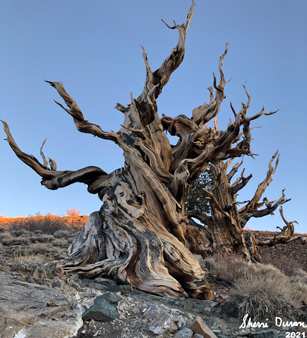
| Worn out Bristlecone Pine tree |
After we finish up with the loop, we continue with the drive down Movie Road. The road is dirt, but well graded. It winds around. We take it slow and enjoy the ride. Eventually, it gets out onto 395. From there, we travel north. At Big Pine, we intend to cut over on Highway 168-same highway number as the one in Clovis, but does not continue over-and go up to the Bristlecone Pine area. But Sherri also would like to get some pastry from Schat’s Bakery in Bishop. It is another 15 miles north. So off we go.
We see a place with Schat’s on the side, so I park and I let Sherri go in. But this is not the place. It is a ways up the road. So Sherri walks up there-I drive, beating her to the bakery. Even at 1:30, there is a long line, but well worth it. Sherri gets us sandwiches: mine is a pastrami; Sherri a white turkey . We go across Main Street to a park and enjoy half of the sandwiches. They are big enough that half is satisfying. We will have the other half for dinner.
Gary on the trail
After
lunch, Sherri goes back over and gets her pastries. Then we take off
to go up the White
Mountains to see the Birstlecone
Pines. The road is interesting. Very winding
and pretty steep. But also interesting in that as we climb the
vegetation changes from grasses to shrubs, to scrub trees. Not the
towering trees we have on the western side of the Sierra, but pines
about 10-20’ tall.

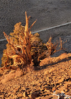 |
| Sunlight catching a tree |
We get to the Schulman Grove area where the visitor center is, but the visitor center is locked up for the season. There are three trail loops which go out of this parking lot. We pick the shortest, the Discovery Trail, about a mile long. We think that is about all we have time before the sun goes down.
 |
| Towards the end of our hike |
Just because it is a mile long, does not mean that it is easy. This trail rises up 350’ and starts about 10,000’. For those of use going from close to sea level up that high, the lung capacity is not great. Fortunately there are a lot of signs to stop and read and ponder. After all, this is a Discovery Trail, so we should be told what we are seeing, or maybe just to discover. We go counter-clockwise around the trail. But as we read the signs I wonder if we are meant to go clockwise. It is a good trail and one which we are glad to go around

When we get back to the car, the skies are darkening and turns to night on the way down. At least now, I have warning when I see car lights that a vehicle is coming up the road. We stop outside of Independence for gas-cheaper than the area around us. By the time we get back to the hotel, it is almost 7pm. We have the other half of the Schat’s sandwiches. The rest of the evening is spent reading till we go to bed around 10.

Extra Photo's
 |
| Gary on Arches Loop Trail |
 |
| Sherri waiting for Gary |
 |
| Looks like a heart =more of a matter of perspective |
 |
| Walrus Rock and Mt Whitney |
 |
| View from our hotel |

 |
| Sherri on the Discovery Trail |
 |
| Gary pondering a couple of trees |
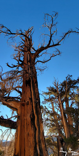 |
| Looking up an old tree |
 |
| Same tree as above |
 |
| Hill to the south of the Schulman Visitor Center |
 |
| Bristlecone Pine Cones |
 |
| Coming down the Discovery Trail |


 |
| Gary approaching the parking ot |


