Tuesday, September 30, 2014

October 1, 2014 - Chain Lakes

Title: October 1, 2014 - Chain Lakes
Trail head: Quartz Mountain
Hike Info:
Type:  Hiking
Trail: Chain Lakes
Destination: Chain Lakes
Distance: 10.33 miles
Start Time:  9:25
End Time:   4:59
Travel Time: 7:33 (1.37 mph)
Moving Time: 5:04 (2.04 mph)
Elevation Rise:  2,174'
Maximum Elevation: 9,152'


Description:
Today's theme is a combination of the Beetles and a bit of serendipity. We start the day  at  6am, in the dark in the Kohl's parking lot.  I have the lively, and if I may say perky, group of Jean, Ellen and Kate in my car. We stop briefly at Starbucks in Oakhurst then we are on our way to the Quartz Mountain trail head. Wayne successfully leads us through the maze of Forest Service roads. But there are other discomforts to along the road which has me thinking of the Long and Windy Road-note the gratuitous Beetles reference. Beside the long and winding way, I add bumpy and dirty to the list of discomforts. Even with the jostling my passengers had to endure, all arrived in good spirits. It takes about an hour and a half to traverse this 20 or so miles. But we get in about 9, ready to hike.
It is cool. My car temperature says 44. Which means it is warm enough for shorts and T-shirt. I am the only one in that attire. I have hiked to Chain Lakes twice before, both over nighters, the last time on a Labor Day weekend about eight years ago. Pleasant memories of friendship, beauty and lostness.
Seventeen of us set off with Jerry J leading us-in this case sheparding us from the rear. Actually Jerry K is even back further, enjoying moments of solitude. I take my accustomed place at the back. Walking is at a swift pace at the beginning, but the initial mile is mostly downhill until we get to the Chiquito Pass, the boundary of Yosemite. It is here which the memories of lostness takes hold. There are four trails which come together at the border. On one of our times where a group went down the wrong trail and each time I have had to figure out which one to take-confusing. Later on the name Chiquito will be noted on another sign in the feminine form Chiquita. Some discussion about this ensued, but apparently these have been used interchangeably over the years.
Lonely Tree
But we choose the right way and go on towards Chain Lakes. The forest is grand to walk through with some rise. Conversations abound. I talk with Kay and her husband Richard B. While I worked at Freano Unified, Kay was engaged as to figure out ways to improve transfers and enrollments-she was enjoyable to work with then and it was fun seeing her now. Another set of conversations was with Kevin. It turns out he is from El Cerrito where my daughter lives. And of course there were talking with others whom I have hiked with before-Richard M about Gene from Copper Creek or Jerry J about things in general. Of course Dennis and I talked about mutual friends.


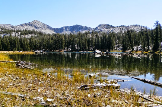
Lower Chain Lake
 While the conversation is good, the miles and the elevation fly by. We come to the last junction and start the final 300' climb and mile and a half to the lakes. There is some tiredness in the group after going 4.5 miles, but others encourage them. No great sights and it is too late in the season for flowers, so I am content with the the interplay of the morning light with the Forest greenness. But this does not last long as we climb over a low ring of rock and dirt; the lower lake pops into view with a ring of mountains in the background. There is the appropriate oohs and aahs. But like the last of the Narnia books might say, further up and farther in.
Gale Peak
We walk up another half mile to the middle of the Chain Lakes. A large island captures the view front and center. This is a good place for lunch. We drink in the sight of Gale Peak as well as munch on the food.


Islands in Middle Chain Lake


 Some of the group decide going up to the Upper Chain Lake sounds good. I stay behind to enjoy the area. Jean, Wayne, Art and Jerry K also stay back. Jean, for some reason, thinks I know how to take pictures. So she poses in several place for new ones of her. I will admit that they do come out, but I sort of think that between the human and natural subjects, it is hard to take a bad picture.
South Fork of Merced Drainage
Jean and I go out on a ridge in front of the lake. There we find a good view of the South Merced River drainage. We can see Merced and Red Peaks. And follow the river until is disappears on the south-west of us. Jerry K camels back from walking around the lake while Art turned back where there was a place which required a bit more advanced mountaineering skills. So Wayne, Jean and I decide to make  our way around the lake. We get to a place and Wayne decides to climb the ridge towering about us. He says that once on top the view is good and the top is flat, as in not rounded. But Jean and I continue around. We then understand why Art turned back and the skill which Jerry K possesses to go around a granite cliff. But the walk has been good, the sun is nice when we spot that the rest of our group has come back from the upper lake.
Tree starting Daniel Talk
Now it is time to come back to the car. Why does the trip back always seem longer than the one coming out? I hike down with Daniel and Max where we talk about a variety of stuff-car buying, house financing, how we consume food and drink from the waste of others, ... Then Jerry J and walk together and Jean joins us until we get to the dreaded boundary of Yosemite.
At this point Jerry J surges ahead, but we are joined by Kevin. We start on the wrong trail for five steps but then go to the trail leading to our cars. We stop often to rest now. On one of these breaks, Kevin sees three of our group. But how could that be? We are the last of the group. Well these three decided to take a scenic, unintentional  tour of Chiquito Lake and now working their way up the hill. We around at the cars around 5, happy. 
Now for the long, bone jarring trip to a Highway 41. The hour and a half which it takes us to do this trip  gives us plenty of time to laugh and be amazed with our conversation. At times it is sort of hard keeping the car on the road from the laughter. We stop at South Gate Brewery for dinner and get back to Kohls after 8. Another good day of hiking.

Trail Lesson:


Middle Chain lake
Lower Chain Lake

Saturday, September 27, 2014

September 27, 2014 - Mariposa Grove to Wawona

Title: September 27, 2014 - Mariposa Grove to Wawona


Trail head: Mariposa Grove
Hike Info:
Type:  Hiking
Trail: Wawona to Mariposa Grove
Destination: Wawona
Actual Destination: Mariposa Grove
Distance: 7.41 miles
Start Time:  9:18
End Time:    1:00
Travel Time: 3:42(2.00 mph)
Moving Time: 3:14 (2.29 mph)
Elevation Rise:  2,272'
Maximum Elevation: 6,029'


Description:
Today is a day of changes. I am going to be hiking with Karol, of Snow Creek fame, and I am really looking forward to it. The idea is to do a nice hike starting at Mariposa Grove in Yosemite and go down to Wawona with shuttle service provided by Yosemite. Such a plan. I had not been on this trail before and was looking forward to doing this connector trail. There is some weather coming through today and Sunday which may bring snow at the higher elevations and definitely some wind and rain.


But first, there was a few things which happened even before going to the 7am meeting place at Kohl's. The first is I could not sleep past 4am-not sure why. But at least I am at Kohl's by 7, but without my iPad. Why is that important? Well, that is where I had loaded my maps of the area. But that is ok since I am just a passenger on this hike, not the captain. Jody and Dana  indicate they are interested in doing a round trip on the hike instead of a one way. That sounds interesting, but it makes more sense to start at Wawona and hike up instead of hiking down and trudging back up again. So John joins us on this and we also pick up Kurt and Alec as they decide to accompany us, but Scott and Julia's family decide to stick to the original plan. 

In Oakhurst, Karol hears of our "mutiny" and considers that she will be going on a hike on Sunday and she has some need to be back in Fresno in the afternoon (looking at Facebook, those "needs" were cute and young), she decides to go back to Fresno and appoints me the leader of the hike. After she leaves, I realize a couple of things:
  1. I have never hiked this trail.
  2. I think I know where to start on the Wawona side, but am not completely sure.
  3. My maps are on my iPad-you know the iPad I forgot.
  4. I hope I can remember the trails from me looking over the map last night.


Incoming Clouds
When we get to Wawona we separate out between the round-trippers and the one-wayers. The one-wayers go to the shuttle bus while I have five people following me, like I know where we are going. I start by going in back of the historic Wawona Lodge and find the Moore Cottage. Sure enough, there is a sign which says Mariposa Grove. How easy it is to look like I know where I am going.


The trail starts off a bit steep. But the conversation keeps everybody's minds off of going up. As it turns out we average about 500' per mile climb. Sometimes the trail does level out and sometimes it goes up enough to cause some perspiration on my part. But the day is cool, actually a bit cold like just before a storm is going to hit. Clouds cover the sky with the sun peeping out occasionally. I do not think it is that cold, probably low to mid 50's, but compared to Fresno a few days ago, it is cold enough. It does keep up hiking well.
Wawona Meadow

Also there is good tree cover with low manzanita.  After about 2 miles, we get to a trail junction with no markings. Both sides look equally probable and I cannot remember exactly what the map says. So I go up the trail 100 yards and say to go follow me towards the road. The trail does come close to the road, but then starts back up the ridge we have been climbing-I choose wisely! The other trail goes down to a 7th Day Adventist camp close to Swinging Bridges.

This is not a trail with great views. It's pleasantness comes more in the form of appreciating the surroundings of pine and cedars with manzanita growing along the path. We also see steam from an earlier sprinkle rising from a downed tree as it warms up. But we do come to some openings where we can look across the valley to a ridge. Also Wawona Meadows shows what a little moisture will do for it, as there is now touches of green while three weeks ago it was all brown then.

Grizzly Giant
As we travel up and around the ridge leading towards Mariposa Grove, the woods change to feature more dogwoods. Dana comments that this area would look pretty with flowers; my return reply is come back in May when the dogwood blossoms are out. Along in this section we meet Scott and Julia and their family and enjoy crossing paths with them.

The sky continues to threaten, but so far no rain. The others are bundled up, but I am down to shorts and T-shirt. The hiking keeps me warm enough. We get to the Mariposa Grove Outer Loop Trail. Yipee, we are at the top. Now it is just an up and down walk for a ways. We make another choice. Since we are going to come back again, we decide to go to the California and Grizzly Giant Trees, about the same distance as to the parking lot.

I feel the awe which I get whenever I come in contact with these big trees, even though there is enough people around that any semblance of solitude is lost. Just enjoying the oldness and largeness of them, wondering what they have seen through the ages and if they could think, what would they think of us? I suspect it would be similar to what we think of ants.

But now we feel a few drops and there is sentiment to take the shuttle back. But instead of going down from the Grizzly Giant, we go back to the junction and take the Outer Loop trail to the parking lot, just short of a mile, From there we wait for about 15 minutes for the next shuttle and enjoy the ride back to Wawona. We realized how much we walked today and how enjoyable, but tiring it was. At the car we say farewell to Kurt and Alec and then depart ourselves to Kohl's. It was a bit early for stopping in Oakhurst.

It has been a good day and glad I have not mislead the group on my virgin outing with the Central Valley Hiking Meetup Group.  I felt strong and enjoyed the experience. I think the group did as well. Not bad for a junior organizer.


Trail Lesson:
We hike to enjoy, speed is secondary.

Wednesday, September 10, 2014

September 10, 2014 - Taft Point and Sentinel Dome

Title: September 10, 2014 - Taft Point and Sentinel Dome

Trail head: Glacier Point
Hike Info:
Type:  Hiking
Trail: Pohono Trail
Destination:Taft and Sentinel Dome
Distance: 7.13 miles 1
Start Time: 10:05
End Time:     3:57
Travel Time:    5:52 (1.22 mph)
Moving Time: 4:17 (1.66 mph)
Elevation Rise:  1,867'
Maximum Elevation: 8,114'
 1I forgot to turn on my GPS on the leg between Taft Point and the Sentinel Dome parking lot. I substituted the GPS data from our June 2014 hike, modifying the time and date of the hike on the spreadsheet. The rest of the data is from the Sept 10, 2014 hike.

Description:
Fire! Smoke! Sweat! Aircraft!  Companionship!
 The story of our hike today.

Got up at 4:45am, not needing to get up that early. After having my quiet time, I noticed that the calendar said to meet at Kohl's at 7. But that cannot be! John's hikes always start at 6. But after going back and reading the particulars, yep, I have an hour to be lazy this morning. At Kohl's I acquire John P and Lewis as riders-later on in Fish Camp we will also add Sonya to our collection. Many interesting discussions on the way up: state law and appeals, hiking-of course, and pharmaceutical customer research. It is always amazing what you learn on these hikes.

The Pohono Trail
We get up to Glacier Point just before 10 and by the time our feet hit the dirt, it is 10. I do not know why, maybe it is doing a 600' slope in the first mile, but whenever I walk the Pohono Trail starting at Glacier Point, I feel like I could die as we climb up this part of the trail. It is not as bad as other trails I have been on. Maybe it is psychological or something. For the most part of our hike, it is a fairly easy walk, once we get beyond the first mile. Later on as I was talking with one of my fellow hikers, I pointed out that when I think something will be really hard, it usually is an easier climb than I prepared my self mentally for; the converse is true too.A bit of rolling over ridges with some great scenes opening up on the valley and the backcountry. What more could a boy want?

Smoky West End of Yosemite Valley
Once we do get beyond that first mile, the hiking gets fun. We get to the trail junction from Sentinel Dome. Do we climb that first? Or go on to Taft Point. Wise hikers will do this counter-clockwise; masochists go to the left. By going to Taft Point first, you get to do your ascension gradually. I am all for that.
Right before Sentinel Creek, we get our first good view of the Valley. But I am waiting till we get to the creek as there is one of the better views in my book there. A well worn social trail of about 50 yards goes on the east side of the creek. After the creek starts falling, there is a flat stone-our family has had lunch there before. This view looks down and up the valley-not a view found in the guidebooks I have read. We stop for a few minutes and then continue on, because, in Yosemite, there is ever so much more to see.

And one of those things is coming up soon as we crossed over Sentinel Creek and climb a ridge or two. But along the way, we see squirrels and deer. The deer seemed a bit unusual, in fact there is two of them. When they spot us, they do not run, but they climb up about 20 yards up from us and then it stalks us as we go along.

Taft Point
Fissures
We top a small ridge and drop onto Taft Point. The smoke from the Meadow Fire is clearing out with the Valley air heating. We pass by the Fissures-always a good thing to gawk at. At times I think of them as cracks into doom-but they do not glow red like Tolkein's Crack of Doom. A good sight we see, being able to see most of the north drainage into Yosemite Valley. From El Cap to  the Three Brothers to North Dome. Just a good sight.


Clouds Rest and Half Dome


Sentinel Dome
Now it is onward to Sentinel Dome, via its parking lot along the Glacier Point road. Once we re-climb the 200' up the ridge we descended, the walking turns easy as it is a gentle three-quarters mile walk to the parking lot. Most of us make use of the facilities and then it is onward to the base of Sentinel Dome.  While I have climbed this several times, it is always exciting to see the 360 degree view. It is even more exciting to go up it with a person who has never been up here. To see a friend through new eyes is always a blessing. I do fold up my hiking poles, as well as Becky's. On the granite like the dome is, they tend to get more in the way, at least that is what I think.

Meadow Fire-Sept 10, 2014
The Meadow Fire is what draws my attention. Sherri and I saw it a week ago when it was just in back of the Mt Starr King-it was only 4 acres then and just puffing out a bunch of smoke. But now is a thousand times bigger, making national headlines. We have seen helicopters flying overhead all day long, about one ever 15 minutes or so. They are serious about this mission. I understand that about 570 people are on the ground fighting the fire.

Meadow and Clarence King Fire on Sept 2, 2014


But the hours is getting late, so down we come. Somehow going back to the car is so much easier. Of course it all downhill. But even downhill can be a strain. For some in our group, today was just a walk in the park; to others it was stretching them to their limits. But by the smiles on all of our faces when we got down to Glacier Point, all had a good time. Even better was the smiles we had in Oakhurst when we stopped at Reimer's for some mouth watering ice cream. We did get back a bit later than John anticipated, but I did not hear anyone complaining.


Trail Lesson:
Imagine conquering the hard hike-the trail turns do-able.


Fire Fighting Helicopter

Fire Fighting Helicopter

Fire Fighting Helicopter


Meadow Fire = John Muir Trail

Meadow Fire - towards Mt Clarence King


Wednesday, September 3, 2014

September 3, 2014 - McLeod Flat/Chilkoot Creek

Title: September 3, 2014 - McLeod Flat/Chilkoot Creek
Trail head:
Hike Info:
Type:  Hiking
Trail: McLeod Flat 4WD Road
Destination: Willow Creek
Distance: 2.13 miles
Start Time:  8:17
End Time:  10:36
Travel Time: 2:15 (0.92 mph)
Moving Time: 1:15 (1.70 mph)
Elevation Rise:  434'
Maximum Elevation: 4,503'

Description:
Sherri, Jerry J, John, Cathey and I walked this trail in August, sort of a pre-hike. Today is much cooler, we also get an earlier start. We meet at Kohl's at 6am, then pick up a couple people in Oakhurst before making our way to Chilkoot Campground and Jerry J. After dropping off the food for our pot luck, we go to McLeod Flat 4WD road. Well sort of. Our car fell behind as we waited for one of the passengers. So we found the road and went down it, but no other cars were there. We turned around and the rest of the hikers came down the road-they were concerned about the roughness of the road and their vehicles.
DD and the Old Car
So we  all walk down the 4WD road, as it descends steeply.  I am thinking that my opinion of the trail is highly conditioned on the trails I have been on the last couple days; dropping into Yosemite Valley and climbing out of Kings Canyon. The dustiness and exposures a bit overbearing. But it is broken up by an abandoned car-it is the most noted thing in the area and our group plays around on it.
Log Crossing


Then we further descend to Willow Creek. We all walk the log bridge across-none fall in. There is not much water to fall into. Then we follow another, near level, dirt road about a half mile until it ends. It is nice to be under a canopy of leaves. But we come to the end of the road and find a little foot path to a large granite sheet. Here Willow Creek drops through a series of holes, eventually down to Bass Lake, but we stop here and enjoy the sight. I wonder what this would look like with water.
Willow Creek

 Our return trip takes us across the creek and up the other side. We navigate a combination of tracks and shelves. Not hard as all we have to do is gently rise up while curving around a ridge. We come out at the old car, then head up the dirt road until we reach our car. Others have to go a bit farther to Beasore Road to pick up their cars.


Willow Creek Valley
Crossing Willow Creek


Trail head: Chilkoot Campground
Hike Info:
Type:  Hiking
Trail: Chilkoot Creek
Destination: Chilkoot Creek
Distance:  .60 miles
Start Time:   12:35
End Time:      2:07
Travel Time:   1:31 (0.41 mph)
Moving Time: 0:32 (1.13 mph)
Elevation Rise:  177'
Maximum Elevation: 4,730'

Description:
Chilkoot Creek
After our potluck, and we did have a lot of luck with that pot, Jerry J leads us on a short walk to Chilkoot Creek. While not short, the trek down is steep. Once we get down, there are some slippery rocks to navigate then a dirt and rock embankment to going sharply down and avoid a degringolade. But all make it down, even though some do go around.

A couple of pools await us. Several frolic in them, but I being sort of stuffy, just lay on the rock, enjoying the sounds of splashing and the sun soaking my skin. After half an hour, we return back to camp. Another place which would be interesting in late Spring.


Jerry K by Willow Creek

Enjoying the shade

Tuesday, September 2, 2014

September 2, 2014 - McGurt Meadow-Dewey Point-Pohono Trail-Artist Point

Title: September 2, 2014 - McGurt Meadow-Dewey Point-Pohono Trail-Artist Point


Trail head: McGurt Meadow Trail Head
Hike Info:
Type:  Hiking
Trail: McGurt Meadow, Pohono Trail, Old Wawona Trail
Destination: Bridalveil Parking Lot
Distance:  10.81 miles
Start Time:  10:06
End Time:     4:53
Travel Time:  6:47 (1.59 mph)
Moving Time:  5:13 (2.07 mph)
Elevation Rise: 1,323'
Elevation Decrease: 4,115'
Maximum Elevation: 7,389'

Description:
Fresh eyes on a much visited place opens the eyes which are jaded. That is what today's travel is about for me. Sherri met Kevin on the LoseIt site. He is from the Boston area and brought his adult son Connor with him to visit a California and more particularly, Yosemite, our stomping grounds.
Kevin

Connor


We met Kevin and Connor at the Bridalveil parking lot. Kevin asks, where are we going? I only point at a high cliff directly above us-he thinks I am kidding, but that is Dewey Point. But first, we take them up to Glacier Point for an initial view of Yosemite. But to our surprise, there are two small fires burning in back of Little Yosemite Valley. Unbeknownst to us, in less than a week later, the little 4 acre Meadow Fire would blow up to a 4,000+ acre fire! Closing down the JMT and Half Dome trail. But today, all which it is doing is spewing out smoke and choking the Valley.

We then do a brief stop at Washburn Point, which normally is one of my favorite views. But between the smoke covering the landscape and the drought drying up the Merced, the view is sadly degraded. So we take a look and continue on our way to the McGurk Meadow trail-head, just a little west of Bridalveil Campground.
Now our hike begins. We move quickly along the trail, passing McGurk's cabin. The meadow, which I think on older maps is called Peregoy, there is a sense of serenity cast by is meadow. It stretches on for about a mile, but being Fall, the vibrant greens is being replaced by the drying yellows and gold.
Gunsight and Royal Arches
At the Pohono Trail junction, we turn west towards Dewey Point. We go through a series of rolling ridges before dropping down to Dewey. I am half expecting to see a falcon, which we do not-several years ago, we were blessed with a falcon sighting at Dewey Point. When I see something unusual in one place, I somewhat always expecting to be there. Kevin and Connor are amazed by the view. There is a photographer in Kevin and he gets his camera going. And there is good reason for this. This is a view which people will do an eight mile round trip for, with El Capitan facing us and Cathederal Rocks so close. When looking at a topo map, one name pops out, The Gunsight, and so it is, taking aim on Royal Arches, as if we were not smart enough to find it on our own.
El Capitan from the south
El Capitan from the west


Crocker Point


We do decide to continue on with our hike-the alternative is to go back the way we did. One thing this hike will not be and that is pointless. In 3/4 of a mile we come to our second point-Crocker Point. Here we see the Valley from a slightly different perspective. We are a bit more out into the Valley, so we have a little longer view to the east. When exiting this point, I take the trail back to Dewey, but only for a hundred yards or so. But then I realize my mistake and we go the next two-thirds of a mile to Stanford Point. More drop-dead gorgeous views.
Now to a place of historic significance and I get to pontificate on it-Old Inspiration Point. This is where the first white men saw Yosemite and where Ayers if sketched the Valley and showed its wonders. But the area has gotten a bit overgrown so the views are inferior to the three others we have seen.
Yosemite Valley
The Pohono Trail does a nose dive and starts a steep downhill. It has been over 30 years since I walked this part and I am anticipating it to be hot and dry and some what exposed, as well as a knee jarring drop. But there is a nice forested cover bringing temperatures down.  So the walking is enjoyable, as much as a prolonged descent can be. Kevin and Connor have moved ahead of us so Sherri and I hike alone. 

Slowly we change from the conifer forest into more of the chaparral oaks and manzanita brush. But the trail is clear and the walking good. Eventually we get to the current Inspiration Point. I will say I am not too impressed with the view. After stopping and resting-Kevin and Connor were waiting for us there- we continue on down. I find a little social trail and follow it for 40-50 yards when I come out onto the classic Yosemite Valley View. Just so good! Too bad everyone else missed it. But it is enough to take it all in.
Classic Yosemite Valley View
A little ways further we come to a junction where the Pohono Trail continues on to Tunnel View. But our route is to follow the Old Wawona Road. From what I can tell, this junction is close to the old Ft Monroe. I will need to find out more of this. 

Old Wawona Road
End of Old Wawona Road
 Going along the  Old Wawona Road has been a desire of mine for the past several years. I keep seeing this road just above Bridalveil parking lot and have been wondering what it looks like. We will be exiting here after walking down the old road. The trail down is pretty good. Most of the road is there, but in a few places we climb over downed trees or follow a narrow path. One place close to Artist Point, we get another good view of the Valley.

When we get back to the car at Bridalveil, we realize how tired we are. But it is an enjoyable hike. Kevin and Connor take us back to our car where we say farewell. Sherri and I return back to Fresno, but not before stopping at Todd's in Oakhurst.

Sentinel and Half Dome
Tenaya Creek area, Clouds Rest and Half Dome

Clouds Rest and Half Dome
Yosemite Valley
Connor

Sherri

Old parsley