
Title: October 1, 2014 - Chain Lakes

Hike Info:
Type: Hiking
Trail: Chain Lakes
Destination: Chain Lakes
Distance: 10.33 miles
Start Time: 9:25
End Time: 4:59
Travel Time: 7:33 (1.37 mph)
Moving Time: 5:04 (2.04 mph)
 Elevation Rise: 2,174'
Maximum Elevation: 9,152'
Today's theme is a combination of the Beetles and a bit of serendipity. We start the day at 6am, in the dark in the Kohl's parking lot. I have the lively, and if I may say perky, group of Jean, Ellen and Kate in my car. We stop briefly at Starbucks in Oakhurst then we are on our way to the Quartz Mountain trail head. Wayne successfully leads us through the maze of Forest Service roads. But there are other discomforts to along the road which has me thinking of the Long and Windy Road-note the gratuitous Beetles reference. Beside the long and winding way, I add bumpy and dirty to the list of discomforts. Even with the jostling my passengers had to endure, all arrived in good spirits. It takes about an hour and a half to traverse this 20 or so miles. But we get in about 9, ready to hike.
It is cool. My car temperature says 44. Which means it is warm enough for shorts and T-shirt. I am the only one in that attire. I have hiked to Chain Lakes twice before, both over nighters, the last time on a Labor Day weekend about eight years ago. Pleasant memories of friendship, beauty and lostness.
Seventeen of us set off with Jerry J leading us-in this case sheparding us from the rear. Actually Jerry K is even back further, enjoying moments of solitude. I take my accustomed place at the back. Walking is at a swift pace at the beginning, but the initial mile is mostly downhill until we get to the Chiquito Pass, the boundary of Yosemite. It is here which the memories of lostness takes hold. There are four trails which come together at the border. On one of our times where a group went down the wrong trail and each time I have had to figure out which one to take-confusing. Later on the name Chiquito will be noted on another sign in the feminine form Chiquita. Some discussion about this ensued, but apparently these have been used interchangeably over the years.
 |
| Lonely Tree |
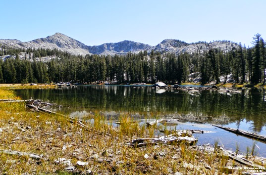 |
| Lower Chain Lake |
 |
| Gale Peak |
 |
| Islands in Middle Chain Lake |
Some of the group decide going up to the Upper Chain Lake sounds good. I stay behind to enjoy the area. Jean, Wayne, Art and Jerry K also stay back. Jean, for some reason, thinks I know how to take pictures. So she poses in several place for new ones of her. I will admit that they do come out, but I sort of think that between the human and natural subjects, it is hard to take a bad picture.
 |
| South Fork of Merced Drainage |
 |
| Tree starting Daniel Talk |
At this point Jerry J surges ahead, but we are joined by Kevin. We start on the wrong trail for five steps but then go to the trail leading to our cars. We stop often to rest now. On one of these breaks, Kevin sees three of our group. But how could that be? We are the last of the group. Well these three decided to take a scenic, unintentional tour of Chiquito Lake and now working their way up the hill. We around at the cars around 5, happy.
Now for the long, bone jarring trip to a Highway 41. The hour and a half which it takes us to do this trip gives us plenty of time to laugh and be amazed with our conversation. At times it is sort of hard keeping the car on the road from the laughter. We stop at South Gate Brewery for dinner and get back to Kohls after 8. Another good day of hiking.
Trail Lesson:
 | |||||||||||||
| Middle Chain lake |
 | |
| Lower Chain Lake |


