
Hike Info:
Type:
Hiking
Trail:
Big Baldy
Destination:
Big Baldy
Distance:
4.28
miles
Start
Time: 1:23
End
Time: 5:28
Travel
Time: 4:04 (1.05
mph)
Moving
Time: 2:41
(1.59
mph)
Maximum
Elevation: 8,232'
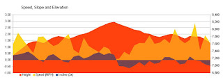 1The GPS shows a climb of
1,236’, but starts at an elevation of 7,223’. The ending
elevation is 7,603’ which is what the topo map shows. The
difference is 380’ which equates to the rise above. As a note, the
GPS shows we descended 1,000’ even.
1The GPS shows a climb of
1,236’, but starts at an elevation of 7,223’. The ending
elevation is 7,603’ which is what the topo map shows. The
difference is 380’ which equates to the rise above. As a note, the
GPS shows we descended 1,000’ even.
 |
| Sherri and Gary at Trail Head |
Description:
So what are we going to do for
a hike today? We are going to Grant Grove. But where? We leave Fresno
about it 11, still with that question. Also, where is the snow? As
we approach the entry station, there is a little bit of snow along
the side of the road. Definitely not enough to snowshoe for.
snowshoes on for.
I have a short discussion with
the entry ranger. He is with the Forest Service rather than NPS and
is on loan as a temporary seasonal person.
We decided to see how
Big Meadows
look. Quail
Flat-does
not have snow and the Little Boulder Creek Road is barred. On to Big
Meadows. A little bit of snow there, but no Winter fun-there is
nothing to put snowshoes on for. So on to the Big
Baldy
trail head.
 |
| Park Ridge Lookout |
 |
| Delilah Lookout |
 |
| Park Ridge Lookout |
 |
| Buck Rock Lookout |
 |
| Buck Rock Lookout |
 |
| Buck Rock Lookout and Beyond |
 |
| Buena Vista Peak |
Out and back is less than 4.5
mile, which is just about right for the remaining time. So we put on
our boots. Then eat our sandwiches before hitting the trail. Right
off the bat, there is a little bit of snow on the trail-maybe an inch
and pretty spotty. So we should not have much trouble as a lot of the
trail is in the sun.
 |
| Looking out over cloud surf |
We have had our usual
pace-going uphill, Sherri is a lot faster. But when we are on the
level or on the descent, I speed up. So the combination is that we
are not walking real fast. Just enough to keep warm-it is in the
mid-50’s. Once we get out of the shade, the temp is comfortable and
we take off a layer of clothes.
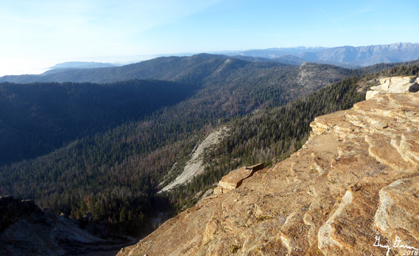
At various places along this
trail, we are able to look down into Redwood
Canyon
and over to Redwood Mountain. Buena
Vista Peak
stands below us. Then following the ridgeline up Park Ridge, I see a
speck where Park
Ridge
lookout is. Cool! It is like, we have been there. Really good to be
able to see the ridge lines from 90o
of Park Ridge. it
is a different perspective. Such as from the lookout, we are looking
straight down the ridge Logger’s
Point is
on. You sort of lose how far away it is. But from here, we see the
whole ridge and see why it is a point.
 |
| Buck Rock with Finger Peak and Mt Goddard |
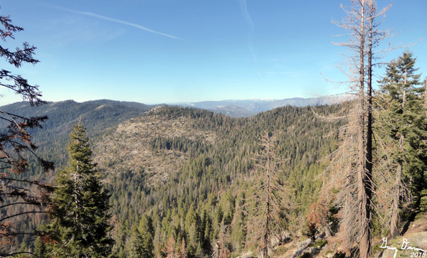
Looking beyond these ridges I
see McKenzie
Ridge
and following Pine
Ridge,
there is a little stick on the north side of the ridge-Delilah
Lookout.
So far away. When at Delilah, we put our binoculars on Big Baldy, we
can pick out individual trees. Fun seeing things in reverse.
There is only one other couple
we see on the trail today. I think they came from Sequoia-Montecito
Lodge as there is no other cars parked by the trailhead, and I see
them right by a trail junction to the lodge. But it does make you
wonder as they are heading away from the lodge trail.
Around 3:15 we get to the top
of Big Baldy. We spend the appropriate amount of time gawking at the
surroundings, about 40 minutes. From here we can see all three of our
lookouts as Buck
Rock has
joined the group. That was a discussion we had-could Buck Rock see
Big Baldy-I could not remember, while Sherri thought it could.
 |
| North Looking |
 |
| East Looking |
 |
| West Looking |
 |
| Two islands in a cloudy ocean |
I should mention the clouds.
It was overcast when we left Fresno but once you get out of the
Valley, it is pretty clear and sunshiny. Now that we are looking
across the Valley, we see an ocean of puffy white stretching as far
as we could see. Occasionally we would see an island in the middle of
a this ocean. These are the hilltops which normally rise above the
Valley, but today they are a set as an oasis in a sea of white.
 |
| Sunset coming on the trail |
We could stay up here for a
long time but it is starting to get late. Sunset should be someplace
around 5 so we take off. We stop often to take pictures and to
navigate a bit of the small patches of downhill snow. The shadows are
lengthening and the light is fading. But we make the car around 5:30,
just as the light fails.
It has been a good hike. The
question now is, where to eat? Bear Mountain? Instead we decide to
see if the restaurant at Grant Grove is open. It is, so we stop here
for dinner. Christine serves us-we have had her as our server before.
She says that Bear Mountain Pizza is in new owners, the pizza people
who used to serve pizza at Grant grove a couple of years ago. We make
it home by 8:00pm, tired and ready for a shower.
 |
| Park Ridge |
 |
| Sherri on trail going towards Big Baldy |
 |
| Big Baldy from North |
 |
| Sherri making it to the top |
 |
| Cloud Creep to the southwest of Big Baldy |
 |
| Spanish Mountain |
 |
| Spillman and Alta Peaks |
 |
| South from big Baldy |
 |
| Redwood Canyon and Park Ridge |
 |
| Fading sun and cloudy ocean |
 |
| Mists invading the valley |
 |
| Sunset on a cloud ocean |

 1The GPS shows a climb of
1,236’, but starts at an elevation of 7,223’. The ending
elevation is 7,603’ which is what the topo map shows. The
difference is 380’ which equates to the rise above. As a note, the
GPS shows we descended 1,000’ even.
1The GPS shows a climb of
1,236’, but starts at an elevation of 7,223’. The ending
elevation is 7,603’ which is what the topo map shows. The
difference is 380’ which equates to the rise above. As a note, the
GPS shows we descended 1,000’ even.


No comments:
Post a Comment