
Hike Info:
Type:
Hiking
Trail:
Wurr Trail, Sequoia Trail, Mount Ellen Trail, Pomponia Trail
Destination:
Mount Ellen
Distance:
5.10 miles
Start
Time: 11:11
End
Time: 3:46
Travel
Time: 4:34 (1.12 mph)
Moving
Time: 4:01 (1.27 mph)
Elevation
Rise: 1,050'
Maximum
Elevation: 912'
Description:
 |
| David and Andrea |
We
were scheduled to go backpacking for an overnighter at Pt
Reyes.
But the forecast kept getting gloomier and gloomier. Going from a
chance of rain to possible thundershowers. So we decided that since
Tuesday looked OK, we would go for a hike someplace. But where? I
suggested Pescadero,
which was agreed upon. Now to decide on what trail.
Yesterday,
I kept feeling like I wanted to take a nap, feeling weakness like
being sick. I am feeling better today. We were to leave around
9:00am, but when I wake up at 8:00am and most of us gets up
afterwards, well it is hard to leave at that time. As a note, David
was up well before us. We get ready and leave around 10:00am. Steven
is taking care of my Mom today. So it is David, Andrea, Sherri and
myself who are in the car. We arrive a little after 11:00am and get
our shows on the trail by 11:20.
 |
| Forest |
 |
| Wurr Trail |
But
which trail? Andrea had found an interesting write up on Redwood
Hikes.It
talks about a loop with a Mount
Ellen.
So that is what we do. We park outside of the San
Mateo Memorial County Park-turns
out because we are seniors, we can park inside for free,
Monday-Friday. Our parking place is by the Hoffman
Trail-not
that we are doing the Hoffman Trail. We park just by that gate.
 |
| Sherri's First hardhsip |
 |
| David in style |
The
first order, once we get our shoes on, is to find the trail. Andrea
and David find a little opening with packed dirt, so we follow that
trail to the Wurr Campground. Here we wander around until we hit the
Wurr Trail. The Redwood Hikes says that the route we are going is the
Summer Route. But it really has not rained that much, so this should
not be a problem, right? After a quarter mile, the Wurr Trail splits
and we go down the Sequoia Trail and need to cross the Pescadero
Creek. Should be simple right?
 |
| Pescadero Creek |
Remember
the Summer Route comment? Well crossing Pescadero Creek is what they
were talking about with the Summer Route. When we got down to
crossing it, while not the fast waters of the Sierra, it was pretty
wide. We may get our toes wet. There were some sticks laid across
the creek and I was able to get ⅔ of the way without mishap-I think
I could have made it all the way across OK.
 | | | |
| Gary on Pescadero Creek |
It
looked like David and Andrea had found an easier way-so let’s go
for it. The way they found included scaling a steep clay hillside,
then coming down, crossing a plank and finally a log. They already
had Sherri doing a batman(woman?) crawl up the slope, so it was too
late for her. I found an easy way across and waited on the other
side, watching the drama. Sherri crossing the plank, a bit hesitant
and then working on a log crossing. Andrea and David helped her. They
finally made it across without a splash.
 |
| Route to the easy crossing |
 |
| Hugging the side of the hill |
Placeholder for a video of the crossing
We
take a brief respite among a stand of redwoods-largest in the park. All exclaim, this is
beautiful. Now it is onward to go and find this Mount Ellen. We pass
the Memorial County Park entrance station and cross the road. There’s
the trail.
 |
| Largest Tree in Park |
 |
| Largest Tree in Park |
 |
| Walking through a stand of Redwoods |
And
now we start our climb. Will I experience the same ascent weakness I
have had since Summer? The first part of the trail is a nature study
trail. We come across lettered posts, but no key to figure out the
meanings. So I supply my to own. We take a left at the first divide.
Turns out the choice did not matter. The nature trail does an
elongated figure eight. So we take the diagonal across and end up on
the east side of the eight, going up the ridge. Probably the gentlest
way up. As we go up, we pass a series of banana slugs, bringing back
fond memories of scouting.
I
do OK, but I am the slow link on the way up. There are only a few
places which gives me a credible “stop and take pictures of this
incredible view “ excuse for stopping. But we are all enjoying the
walk, so their is not a reason to be too macho. On the other hand,
my daughter called me a “fun guy”-I think that is what she said.
(Think about it, or look at some of the pictures at the bottom of
this blog.)
 |
| Enjoying a view |
The
actual top of the trail sort of comes and goes with us wondering if
this was really it-it was not. Since it is 1:15pm, time to take a
lunch break. PB&Nutella sandwiches. We stop for about 20 minutes.
Only a small view towards the north.
 |
| Pomponia Canyon Trail |
 |
| Looking down on Mount Ellen |
 |
| Sherri and Andrea enjoying view |
A
short way along the trail down, we meet up with a trail junction for
the Pomponia
Canyon Trail.
This will take us up along the ridge, adding about two miles more.
All of us were agreeable to the extension, so off I charge up the
ridge. Turns out, about a third of a mile up this trail is Mount
Ellen. So one way or another, we conquered it.
This
part of the trail is a single track trail. It climbs the ridge which
Mount Ellen is part of. We wade in and out of brush, all of which is
cut well away from the trail. While we spot some poison oak, we may
have rubbed against it only incidentally. On the other hand, there
are a ton of berry plants around the trail. I can only imagine the
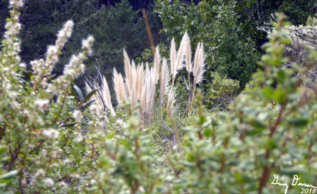
scents when they are ripe. We also see some plants which look out of
place-more wet ground plants-Pampas Grass. David says these are
symptoms of cracks where there are earthquake faults.
 Towards
the end of the ridge we can look down on Mount Ellen, about 200’
below us. Just like in the Redwood Hikes picture. Also there are
signs warning that the trail is in a dangerous condition. But it
looks like a trail crew has come in and repaired the damage.
Towards
the end of the ridge we can look down on Mount Ellen, about 200’
below us. Just like in the Redwood Hikes picture. Also there are
signs warning that the trail is in a dangerous condition. But it
looks like a trail crew has come in and repaired the damage.
 |
| Life from a stump |
Now
it is time to return back to the car. Our trail turns into a narrow
two track road. As we descend, the vegetation turns lush, with
redwoods lining the road. While not wet, the dampness of the area is
evident. Ferns grow along with an assorted bunch mushrooms and fungi,
and, of course, more banana slugs. To me, what is amazing to me is
that the area has the stumps of lumbered redwoods. Out of several,
stumps arise new trees. How can something dead give life? That is a
question these trees pose to me.
 |
| Little waterfall |
We
hit the road again and cross it. Here, we spot a nice little
waterfall, before entering the campgrounds for this county park. I
have seen few better campsites than these and several a lot worse.
After walking the length of the campgrounds and picnic area, we
resist the temptation to do the log crossing of this morning, and
return the last quarter of a mile via a road.
We
get back to Mountain View where Steven has been taking care of my
mom. He has dinner all prepared and ready to be cooked. After
showering, it was good to eat a good dinner.
 |
| Sherri, Gary, Andrea and David towards last of hike |
============
 |
| Andrea, Sherri and Gary in San Francisco |
 |
| Our greeter at Steinhart |
Wednesday
we decided to go to the City and spend time at the California Academy
of Science. We spent about three hours there, viewing a planetarium
show on Dark Matter. Then, going through a hands on lab where you
could see and touch fur and bones. Then up to the roof to see their
living roof. Because of lines at the rain forest and earthquake
exhibits, we decided to for go those areas ans visit Steinhart
aquarium-well worth the venture. We wrapped it up by seeing the
African penguin feeding. Fun day. Then dropped Andrea off after
eating at a Salvadorian restaurant in El Cerrito, Taqueria
El Salva Mex Pupuseria. (Good food, small)
 |
| Living Roof |
Background
San
Mateo Memorial County Park. 673 acres with camping. Environment
ranges from lush surroundings along the canyons up to open areas with
nice visits along the ridges. The park was acquired in 1924. During
the Depression, it housed workers from the Works Project
Administration. After World War II, it was named for the men who lost
their lives during the war.
 |
| Gary Waiting |
 |
| The Easy Route |
 |
| Andrea looking up at the Park's largest tree |
 |
| Sherri among the leaves |
 |
| Stand of Redwoods and light |
 |
| Looking down on Mt Ellen |
 |
| Sherri on the Pomponia Canyon Trail |
 |
| Moss covered tree |
 |
| Gary gone wild |
 |
| What is this building? |
 |
| Tree on stump |
 |
| Hiking Gary |
 |
| David on a stump |
 |
| Sherri's last obstacle |


 Towards
the end of the ridge we can look down on Mount Ellen, about 200’
below us. Just like in the Redwood Hikes picture. Also there are
signs warning that the trail is in a dangerous condition. But it
looks like a trail crew has come in and repaired the damage.
Towards
the end of the ridge we can look down on Mount Ellen, about 200’
below us. Just like in the Redwood Hikes picture. Also there are
signs warning that the trail is in a dangerous condition. But it
looks like a trail crew has come in and repaired the damage.


No comments:
Post a Comment