Title: June 19, 2018 - Vanderberg Lake to Fernandez Trailhead
Hike Info : Description : Trail Lessons : Menu : Extra Photo's : Flowers and Plants
Trail head: Vanderburg
Lake
Hike Info:
Start
Time: 10:31
End
Time: 3:10
Travel
Time: 4:39 (1.01
mph)
Moving
Time: 2:43
(1.73
mph)
Elevation
Rise: 446
'
Descent: 1,637‘
Maximum
Elevation: 8,232'
1Because of some confusion of where I was in relationship
to Rose and Sherri, I backtracked about a quarter mile to see if I
had missed them. Also as a note, someplace on this hike, the
elevation readings were dropped. So the elevation information is off
of Google Earth’s estimates.
Distance: 5.15
miles
Travel Time:
4:39 (1.11 mph)
Moving Time: 3:01
(1.71 mph)
Elevation Rise: 571'
Descent: 1,762‘
Description:
Got up 7:45. I must have been somewhat rested as I woke
up several times last night and stayed awake for awhile. Nothing
profound. I had a short quiet time and then went exploring about how
to get across Madera
Creek. Had our breakfast and then
got things packed. Evidently breaking camp is not our specialty as it
took us until 10:30 to hit the trail.
 |
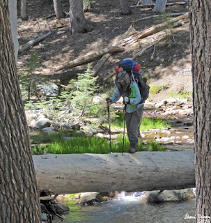
| Rose Log Crossing |
From my earlier scouting of the area, I thought I had a
plausible way across the creek without taking off boots. But I seem
to have misplaced it. Am I getting that old? This is the third time
this summer which I was not on the ball in my navigational skills.
 |
| Rose and Sherri and a steep place |
We do cross Madera Creek safely: Sherri and I rock
hopping; Rose doing a high log balancing act. We are downstream a
little ways from the trail, So I propose we head up the slope and
then angle over to get to the trail. We do this without too much
struggle, and nor buck brush or manzanita. The trail comes up shortly
and we are almost at the top of a ridge.
From the top of the ridge, we lookout over where the
waters drain into the San
Joaquin River. This includes the
areas where we have hiked, but also views all the way to the crest of
the Sierra. After returning, we see that there was a fire called the
Lion’s Point fire straight across from us. But we do not see any
smoke with our naked eyes or later on our the pictures. Mt
Ritter is still with us, but not
for long.
 |
| Lion's Point Fire Location |
As we descend, we realize how steep the ascent was. We
also get into more the meadows which we passed up earlier. There are
two things which really impress us about these meadows, first is the
variety of flowers in bloom, Particularly the Hartweig Iris seem to
be all over the place. The second is the abundance of mosquitoes
which have found us so quickly
 |
| View of the Sierra Crest |
After a quick stop to film the flowers and meadows
before the mosquitoes get to me, I take off and catch up with Rose.
She wants me to pass her-I guess it is a bit intimidating to have
this huge person pondering dirt right behind you. I think Sherri is
in front of me, so I hurry a bit to catch up with her. It feels good
to stretch out my legs a bit and the general direction is down, not
steeply. So I do pretty good. After going on close to an hour, there
has been no sign of Sherri, which gets me to thinking, where is she?
I hit the junction with Lillian
Lake and decide to continue on
down to the Norris Trailhead junction. Still no Sherri. So I drop my
pack and head backpack and head back to the previous junction and
wait.
 |
| One of many meadows |
We had a few snacks. A few pictures on top of a small rise and we got our final view of the tip of the Sierra Crest. Just a good way to say goodbye to the area. And then we were off. It was about another mile and a half down to the trailhead. But it seemed like it took us awhile to o this easy downhill. May have been the heat. But we got back to Rose’s vehicle at Fernandez Trailhead in good shape and good spirits.
The drive back was long, but not as eventful as the
drive to the trailhead. We stopped at El
Cid’s for dinner. Sonya met us
there and we had a pleasant conversation. Then went across the
parking lot to Remier’s
for ice cream. A good way to end a
trip.
Trail Lesson: You never know how bad of a climb it was until you come
down it. Sherri
Menu
| Breakfast | Lunch | Dinner | Snacks |
| Oatmeal and add-ins, such as dried peaches, strawberries, nuts, granola. Tang. | Ritz Crackers, Peanut Butter, Nutella |
El Cid restaurant
Reimer’s ice cream
|
Clif Bar, GORP, Propel, CytoMax, Scratch, Coffee Candy, Jelly Belly |
Extra Photo's
 |
| Mt Ritter |
 |
| Gary, the missing hiker |
 |
| Unnamed meadow |
 |
| Unnamed meadow |
 |
| Snow patch |
Flowers and Plants


No comments:
Post a Comment