
Title: May 19, 2016 - Ft Monroe
Hike Info : Description : Background : Extra Photo's : Flowers and Plants

Trail head: Bridalveil Falls Road
Hike Info:
Type: Hiking
Trail: Old Wawona Road
Destination: Ft Monroe, maybe beyond
Actual Destination: Ft Monroe
Distance: 6.91 miles
Start Time: 10:19
End Time: 2:09
Travel Time: 3:49 (1.81 mph)
Moving Time: 3:16 (2.12 mph)
Elevation Rise: 1,760'
Maximum Elevation: 5,581'

Sherri and Steven want to bike ride around Yosemite Valley, so this gives me about three hours to go hiking and wandering. The biggest challenge is where? What am I in shape for? What is of interest to me? What is the meaning of life? Oops, not the last. So after doing a fair amount of pondering, I decide to walk the Old Wawona Road to Ft Monroe. With a little bit of effort, I might be able to go beyond where Ft Monroe is and explore a bit. But this might be optimistic.
We leave Fresno around 7:45. I need to stop at Kaiser to pick up a prescription. While I am doing that, Sherri and Steven pick up gas for the car at Costco. Then it is off to Yosemite and adventure. We get to Bridalveil after a brief stop at Chinquapin for their bathrooms. Instead of parking in the Bridalveil Falls Parking Lot, we have to park along the road a couple hundred yards away. By the time I start walking, it is 10:15.
 |
| Beginning of Old Road |
 |
| Downed Trees |
 |
| Ribbon Falls |
 |
| View from Artist Point |
After properly gawking here and trying to find the benchmark-which I don't see, I continue my walking. On the way up, I see a couple looking for Artist Point and I point the way and continue on with mine. Instead of going directly up to New Inspiration Point, I continue on the more gentler route with the road. It goes up and gives a good, but not the greatest, view of the Cascade Falls area. After that, and a few more trees to go over and around before I hit Inspiration Point.
 |
| Cascade Falls From Ft Monroe |
 |
| Old Pipe |
 |
| Cascade Falls |
 |
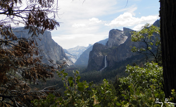
| Yosemite Valley from Inspiration Point |
But now it is time to return. The first bit is down the road I just came up. But then it is downhill, sol I make good time. I stop at Inspiration Point to get the "standard" photo from there. The view is good and Yosemite looks fabulous. Also Bridalveil is good looking. One can stay up here forever with a mouth open, gaping at this. But I need to go on.
 |
| Bridalveil Falls from Inspiration Point |
Why you might ask? First, because Sherri and Steven will be waiting for me at the parking lot. But also because there is another view which I like a lot better. I call it "Gary's Point". But I know I am not the first to find it, only one of many who has come across it because there is a path to it, away from the Pohono Trail-which ends at Tunnel View. I found this view a few years ago when I was walking this trail with a few other people and came across the path. I took it to see where it went and saw the best view of the Valley. As a bonus, the path points straight to Silver Strand Falls
 |
| Yosemite Valley from "Gary's Point" |
 |
| Silver Strand and path to Gary's Point |
 |
| Trees across road |
I get to the car without incident around 2:10. Sherri and Steven have been waiting for me for about half an hour. They had made two loops around the Valley floor and enjoyed their time. So off we go to Oakhurst and the Southgate Brewery before heading home.

Background
See my write up on Artist Point, Ft Monroe and the Old Wawona Road for more information on these items.
Extra Photo's
 |
| Yosemite Valley |
 |
| Ribbon Falls and El Capitan |
 |
| Cascade Falls and the Devils Dance Floor |
 |
| Afternoon shot of the Valley from Artist Point |
Flowers and Plants

 |
| Puffball Fungi |
 |
| Phlox |
No comments:
Post a Comment