Title: June 16, 2024 - Bearskin Grove, Not quite

Type: Hiking
Trail head: Junction of 13S02 and 13S45
Trail: 13S45
Destination: Bearskin Grove
Actual Destination: On top of a ridge on a different road
Distance: 2.25 miles
Start Time: 2:26
End Time: 4:17
Travel Time: 1:51 (1.22 mph)
Moving Time: 1:17 (1.76 mph)
Elevation Rise: 558'
Descent: 514‘
Maximum Elevation: 6,630'
 |
| Sequoia in Bearskin |
Today is Father’s Day. As my Father’s Day wish it was to go hiking, particularly to a place I have not been before, Bearskin Grove. I have seen it on the map and heard it on the radio-but more in connection with the campground than the grove. Plus a couple Facebook friends went there a couple of weeks ago, so it is fresh in my mind.
We decided to go after church. But first we need to load up the car. The car had been in for a facelift after its encounter with a deer last month. We just got it back Friday. We reload it with the necessities of life: hiking boots and poles and a few other things. Then have lunch and are off by 12:30.
The drive up is without incident. It is slow though as it seems like a good many people have the same idea of going to the mountains. Also it is Sunday and Hume Lake Christian Camps are getting a new load of their campers. But we make it up to Quail Flat and then down Ten Mile Road about five miles until we see road 13S02. Surprise! A forest service road which is paved and seemingly paved to nowhere. Where it stops being paved, the Redwood Hikes website says to park. But Hume Lake has established a drop off site there for something called Wildwood. After asking about parking there, we decided to move a little ways further down 13S02.
 |
| Steven |
So I lightly blame Hume Lake for my confusion which exhibited itself when I parked. The confusion you might ask? Is road 13S45 the right road? What is the right one? The right one is road 13S98 and 13S98A. This road is 13S45. Rather than go back, I decide that we can do Bearskin another day and we will see where 13S45 leads us. It looks like on the map that we will be looking across to Bearskin.
We take off at 2:30. It is amazing how late things can be if we get a late start, have slow traffic and am confused at the start. The start of the road is steep, and exposed, and steep. It feels like around a 20% grade. We shall see how long we go, but at the latest, I am looking at a 3:30 turn around time.
The good thing about climbing up steeply is that you get to see things. First, there are the Sequoias of Bearskin Grove. The next best thing to being among them, is being able to gaze at them completely. Almost all of the Sequoias which I have seen are majestic and are worthy of our admiration.
The second thing we see is Buck Rock
 |
| Buck Rock Lookout |
Once we get close to the top of the ridge, the elevation gain starts to level out. Also we enter into an area where the trees provide shade. The walking becomes a lot more pleasant. It is amazing how the road can be the same, and yet the surroundings change, making such a difference in my outlook. Something to remember that as I continue on this road of life, there will be dry spots, but be sure to have those areas of refreshment.
At the end of the ridge, the road doubles back with a horseshoe bend. We stop here and rest and enjoy the sight. We look across the Kings with a good view of Spanish Mountain. But no view of the closer Hume Lake. There are trees blocking my view of the Mt Goddard area, so we just have to be content with some of the other snow-covered mountains to the east.
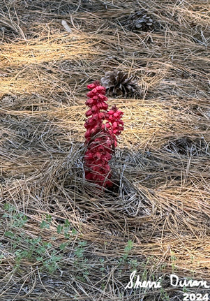
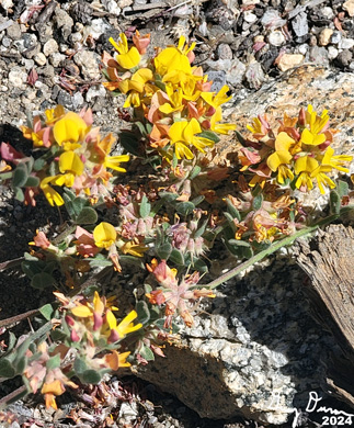
We decided that since it is close to 3:30, which is my turn around time, we will turn around now. Going down has a lot less strain on my muscles. But it is a lot more jarring to my bones. The first part back gives me many stops to take pictures of the flowers, but when we reach the section which is exposed to the sun, I am ready to get down the slope a bit quicker-not fast, just quicker than to lally-gagg around.
 |
| Sherri on the trail |
We get in the car and leave at 4:30. I drive us back to Big Stump, passing the WildWood people on the way out. At Big Stump, Sherri calls in the order to Bear Mountain Pizza and then Steven takes over driving. When we get to Bear Mountain, and I am getting out of the car, I hear the shout, Gary! Looking around, there is Brianna from Snapps, our car mechanic’s receptionist. We talked for a few minutes. She warns us that it is an hour wait, but we have ordered ahead, so it is only a ten minute wait.
After being fed, Steven takes us home. Road 13S45 is definitely not a must see. Still it was a good enough walk, particularly with the flowers and seeing Buck Rock. Looking at the roads which connect with it, I think there is a connection to some of the Forest areas behind Park Ridge Lookout where we cannot see. Maybe another day when I have more energy.
Trail Lesson:
Know where you are going before you get going.
On the road of life, there will be dry spots; that is part of the journey. Appreciate those areas of refreshment.
Background
The actual directions to Bearskin Grove is: Park on paved road 13S02; there’s a pullout just a few yards past road 13S98.
Two old logging roads run through the grove. Road 13S98A climbs through the best part of the grove. The short road is open to vehicles and is in drivable condition, although it’s a little rough. The road climbs past about 10 or 12 massive sequoias, including two especially large giants on the left that have very little taper. A lot of logs are scattered around from the 2022 fuel reduction program. From Redwood Hikes
Extra Photo's
 |
| Garlic Meadow |
 |
| Sequoia in Bearskin Grove |
 |
| Spanish Mountain on the right |
Flowers and Plants
 |
| Snow Plant |
 |
| Mountain Misery |
 |
| Penstomen |
 |
 |
| Hartweg Lily |
 |
| Mariposa Lily |


No comments:
Post a Comment