Mount Hoffmann-10,771' (Yosemite Falls) (37.8465899, -119.5101635)
Hoffmann Creek-7,831' (Yosemite Falls) (37.8093683, -119.5182184-Mouth)
 |
| From Up and Down California by William Brewer
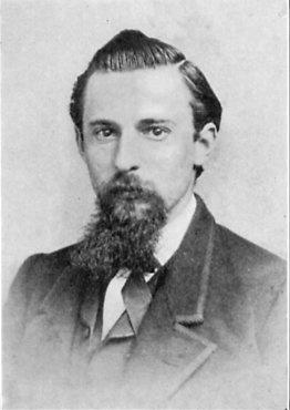
Charles F. Hoffmann |
Charles Frederick Hoffmann was born at Frankfurt-am-Main, Germany, 1838, and was educated in engineering before coming to America. In 1857 he was topographer for Lander’s Fort Kearney, South Pass, and Honey Lake wagon-road survey. He came to California in 1858. Next to Whitney himself, he had the longest connection with the California State Geological Survey, remaining through all vieissitudes until its discontinuance in 1874. During a hiatus in the Survey, 1871-72, he served as Professor of Topographical Engineering at Harvard. In 1870 he married Lucy Mayotta Browne, daughter of J. Ross Browne. For many years he was associated with his brother-in-law, Ross E. Browne, in the practice of mining engineering, for a time at Virginia City, Nevada, later at San Francisco. He also managed mines in Mexico, and at Forest Hill Divide, California, and investigated mines in Siberia and in Argentina. During the latter part of his life he lived in Oakland, where he died in 1913. The importance of his work on the California Survey and its influence upon the development of topography in the United States have been mentioned in the introduction to this volume. From Up and Down California: The Journal of William H. Brewer, 1860-1864 Book II, Chapter 1, Footnote 5
 |
| From Up and Down California by William Brewer
Charles F. Hoffmann |
====
Ramble to the summit of Mt. Hoffman, eleven thousand feet high, the highest point in life's journey my feet have yet touched. And what glorious landscapes are about me, new plants, new animals, new crystals, and multitudes of new mountains far higher than Hoffman, towering in glorious array along the axis of the range, serene, majestic, snow-laden, sundrenched, vast domes and ridges shining below them, forests, lakes, and meadows in the hollows, the pure blue bell-flower sky brooding them all, --a glory day of admission into a new realm of wonders as if Nature had wooingly whispered, "Come higher." What questions I asked, and how little I know of all the vast show, and how eagerly, tremulously hopeful of some day knowing more, learning the meaning of these divine symbols crowded together on this wondrous page. From John Muir, My First Summer in the Sierra
====
This is a frequently climbed peak and there is an outstanding view from the summit (if you ignore the radio repeater installed there. South Slope. Class 2. First ascent June 24, 1863 by Josiah Whitney, William Brewer and Charles Hoffmann. The south slope can be easily reached either from May Lake or Tioga Road. From R.J. Secor's High Sierra Peaks, Pass and Trails. Second Edition
=====
Named by the Whitney Survey in 1863 for Charles F. Hoffmann, principal topographer of the survey. (Whitney Survey: Geology, 1865, p. 424.)
Charles Frederick Hoffmann (1838-1913); born at Frankfurt-am-Main, Germany; educated at an engineering school; topographer with Frederick W. Lander on Fort Kearney, South Pass, and Honey Lake wagon-road survey, 1857; came to California, 1858; member of California State Geological Survey, under Josiah Dwight Whitney, throughout its existence, 1860-1874; professor of topographical engineering, Harvard, 1871-1872; married Lucy Mayotta Browne, daughter of J. Ross Browne, 1870; associated with brothers-in-law, Ross E. Browne and Alfred Craven, in mining engineering at Virginia City, Nevada, 1874-1876; managed mines in Mexico, and at Forest Hill Divide, California, 1878-1886; investigated mines in Siberia and in Argentina; associated with Ross E. Browne in practice of mining engineering, with offices in San Francisco, 1888-1906. (Ross E. Browne.) Portrait in S.C.B., 1923, XI:4, plate cxi, and S.C.B., 1925, XII:2, plate XLIV.
Whitney says in a letter to his brother, May 3, 1862: “Hoffmann does as well in his place as anyone could possibly do. He is a German, twenty-four years old, formerly topographer to Lander’s wagon-road expedition, with a capital eye for hills and orography in general, and no vices.” (Brewster: Life and Letters of Josiah Dwight Whitney, 1909, p. 214.)
Whitney, Brewer, and Hoffmann were in the vicinity of Mount Hoffmann in 1863, and one or all may have climbed it. The summit and the view are described in the report. (Whitney Survey: Geology, 1865, p. 424.) Clarence King climbed it in October, 1864. (King: Mountaineering in the Sierra Nevada, 1872, pp. 144-145.) In 1867 a photograph was taken of the summit by W. Harris, showing Hoffmann himself with his transit. This photograph is among the plates accompanying The Yosemite Book, issued by the Whitney Survey in 1868. (See, also, S.C.B., 1923, XI:4, plate CXIII.)
John Muir climbed Mount Hoffmann, July 26, 1869. “Ramble to the summit of Mount Hoffmann, eleven thousand feet high, the highest point in life’s journey my feet have yet touched.” (Muir: My First Summer in the Sierra, 1911, p. 199.) From Place Names of the High Sierra (1926) by Francis P. Farquhar
=====
From GNIS about Mount Hoffman.
- In Yosemite National Park, at the head of Hoffmann Creek and 1.6 km (1 mi) west of Mayb Lake.
- Original decision card for Mount Hoffmann
- Also called:
- Hoffman Peak: U.S. Board on Geographic Names. Geographic Names Post Phase I Board/Staff Revisions. 01-Jan-2000. Board decisions referenced after Phase I data compilation or staff researched non-controversial names.
- Mount Hoffman: U.S. Geological Survey. Geographic Names Phase I data compilation (1976-1981). 31-Dec-1981. Primarily from U.S. Geological Survey 1:24,000-scale topographic maps (or 1:25K, Puerto Rico 1:20K) and from U.S. Board on Geographic Names files. In some instances, from 1:62,500 scale or 1:250,000 scale maps.
Trips:
References:
- Yosemite Hikes
- Wikipedia
- Peak Bagger
- DeAnza College annual trip notes
- Kevin Gong's hiking page. Pretty good description of his hike
- Gilroy Dispatch July 11, 2015 hike challenge
- Ted Muller's hike description-another good description
- John Muir, My First Summer in the Sierra


No comments:
Post a Comment