East Fork Kaweah River-1,283' (Case Mountain)
(36.4791130, -118.8384322)
Marble Fork Kaweah River-2,028' (Giant Forest) (36.5138344, -118.8023207)
North Fork Kaweah River-807' (Kaweah) (36.4474474, -118.9023224)
South Fork Kaweah River-758' (Kaweah) (36.4235589, -118.9195448)
Kaweah Camp-6,466' (Giant Forest (36.5657782, -118.7745430)
Kaweah Basin-11,283'(Mt Kaweah) (36.5452157, -118.4814817)
Kaweah Peaks Ridge-13,789'(Mt Kaweah) (36.5260268, -118.4785312)
Kings-Kaweah Divide-12,313' (Triple Divide Peak) (36.5978644, -118.5529965)
Kaweah Gap-10,689' (Triple Divide Peak) (36°33′23″N 118°33′04″W)
Mt Kaweah-13,796' (Mount Kaweah ) (36.5260491, -118.4784256)
Red Kaweah-13,619' (Triple DIvide Peak ) (36.5396605, 118.5056486)
Black Kaweah-13,586' (Triple Divide Peak) (36.5452164, -118.5156489)
Kaweah Queen-13,366' (Triple Divide Peak) (36.5546554, -118.5085537)
Kaweah Post Office (Unknown) (Unknown)
Description:
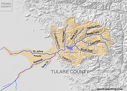
The Kaweah River has four principal forks: North, Middle, East, and South. The Marble Fork is a branch of the Middle Fork
.
“Kaweah River is named after a Yokuts tribe called Kawia, or probably more exactly, Gā'wia. They lived on or near the river where it emerges from the foothills into the plains. The name has no known connection with the almost identically pronounced southern California town Cahuilla.” (Kroeber: California Place Names. of Indian Origin, 1916, p. 44.)
Colonel George W. Stewart, an authority on the Indians of this region, considers the translation sometimes given, “I sit here,” to be incorrect.
“The next stream we came to was the Pi-pi-yu-na, or Kah-weé-ya, and very commonly known as the Four Creeks. Immediately upon leaving the mountains, like the Kings River, it divides itself into several streams; but, unlike those of that river, they do not unite, but continue to diverge, forming a delta, whose base is over fifteen miles long.” (Williamson: Report of Explorations in California, Pacific Railroad Surveys, 1853, V:1, p. 13.)
Place Names of the High Sierra (1926) by Francis P. Farquhar
The Kaweah Peaks are called, from east to west: Mount Kaweah (13,816), Second Kaweah (13,728), Red Kaweah (13,754), Black Kaweah (13,752).
“Mt. Kaweah is the form which has long been used locally for the round-topped peak in the Kaweah group,—not ‘Kaweah Peak.’ As the collective name ‘The Kaweah Peaks’ is so often used, ‘.Mt. Kaweah’ is more distinctive.” (William R. Dudley, in S.C.B., 1903, IV:4, p. 306.)
The first ascent of Mount Kaweah was made in September, 1881, by J. W. A. Wright, of Hanford, F. H. Wales, of Tulare, and W. B. Wallace, of Visalia— (Elliott: Guide to the Grand and Sublime Scenery of the Sierra Nevada, 1883, pp. 47-49, 59.) They named the peaks, from left to right: Mount Abert (for Colonel John J. Abert, one time Chief of Topographical Engineers, U. S. Army); Mount Henry (for Professor Joseph Henry, of Princeton); Mount Le Conte (for Professor Joseph Le Conte, of the University of California) and Mount Kaweah. The first three names were not given sufficient publicity and have lapsed from use.
First ascent of Red Kaweah, July, 1912, by Charles W. Michael. (S.C.B., 1913, IX:1, p. 48.)
First ascent of Black Kaweah, August 11, 1920, by Duncan McDuffie, Onis. Imus Brown, and James S. Hutchinson. (S.C.B., 1921, XI:2, pp. 131-134.—See, also, S.C.B., 1922, XI:3, pp. 311-312; S.C.B., 1923, XI:4, p. 440.)
From Place Names of the High Sierra (1926) by Francis P. Farquhar
The great black masses of the Kaweah Group were blacker still with a formida ble thunder storm slowly gathering about its peaks. From The Pass by Stewart Edward White, chapter We Fall Back
Above the frozen monster towered the bleak and forbidding peaks of the Kaweah Group abruptly down to where a bend in the canon concealed what must have been the beginning of the pine country.
From The Pass by Stewart Edward White, chapter The Side Hill Camp
From The Pass by Stewart Edward White, chapter The Side Hill Camp
From GNIS:
- Red Kaweah
- In Sequoia National Park, on the west side of Kaweah Peaks Ridge, 1.1 km (0.7 mi) southeast of Black Kaweah and 2.9 km (1.8 mi) northwest of Mount Kaweah
- From the decision card: Climbed in 191£, by Charles W. Michael, Sierra Club,
Bull., vol. IX, if, p. 48, 1913. - Also called Mount Henry-Gudde, Erwin G. California Place Names: A Geographical Dictionary. Berkeley, California: University of California Press, 1949. p171
- Black Kaweah
- In Sequoia National Park, on the west side of Kaweah Peaks Ridge,1.1 km (0.7 mi) northwest of Red Kaweah and 1.3 km (0.8 mi) southwest of Kaweah Quen.
- Also Mount Abert: Browning, Peter. Place Names of the Sierra Nevada. Berkeley, California: Wilderness Press, 1986. p115
- Mt Kaweah
- In Sequoia National Park, on the southeast end of Kaweah Peaks Ridge, bound on the north by Kaweah Basin and 4.5 km (2.8 mi) west of Red Spur.
- Kaweah Queen
- In the Sierra Nevada, in Sequoia National Park on Kaweah Peaks Ridge 1.1 km (0.7 mi) north-northeast of Black Kaweah.
- Kaweah River
- Heads in Sequoia National Park at the junction of Marble Fork Kaweah River and Middle Fork Kaweah River, flows southwest through Terminus Reservoir, to the junction of Mill Creek, Packwood Creek, and Oakes Ditch.
- Also called:
- Caweea-Durham, David L. California’s Geographic Names. 31-Dec-1998. Clovis, CA : Word Dancer Press.
- Cawia-Browning, Peter. Place Names of the Sierra Nevada. Berkeley, California: Wilderness Press, 1986.
- Cow-eer-Browning, Peter. Place Names of the Sierra Nevada. Berkeley, California: Wilderness Press, 1986.
- Kah-wah-Browning, Peter. Place Names of the Sierra Nevada. Berkeley, California: Wilderness Press, 1986.
- Kah-wee-ya *-Gudde, Erwin G. California Place Names: A Geographical Dictionary. Berkeley, California: University of California Press, 1949.
- Keweah River
- Middle Fork Kaweah River
- Pi-pi-yu-na-Browning, Peter. Place Names of the Sierra Nevada. Berkeley, California: Wilderness Press, 1986.
- Rio De San Gabriel-Gudde, Erwin G. California Place Names: A Geographical Dictionary. Berkeley, California: University of California Press, 1949.
- River Frances-Gudde, Erwin G. California Place Names: A Geographical Dictionary. Berkeley, California: University of California Press, 1949.
- San Gabriel River-Browning, Peter. Place Names of the Sierra Nevada. Berkeley, California: Wilderness Press, 1986.
- The Four Creek-Browning, Peter. Place Names of the Sierra Nevada. Berkeley, California: Wilderness Press, 1986.
- East Fork Kaweah River
- Also called East Fork of Kaweah River
- 21 miles long. Partialy in Sequoia National Park, heads between Vandever Mountain and White Chief Peak, flows west-northwest to Kaweah River 7.2 km (4.5 mi) northeast of the village of Three Rivers.
- Marble Fork Kaweah River
- 16 miles long. In Sequoia Natoinal Park, heading 2.1 km (1.3 mi) northeast of Moose Lake, flowing southwest to the Middle Fork Kaweah River 28.8 km (18 mi) northeast of the city of Woodlake.
- Also called:
- Marble Fork Creek
- Marble Fork of Kaweah River
- North Fork Kaweah River
- 20 miles long. Heads on the boundary between Kings Canyon and Sequoia National Park at the junction of Dorst Creek and Stony Creek, flows south-southwest to the Kaweah River 0.8 km (0.5 mi) north of the village of Three Rivers.
- Also called North Fork of Kaweah River
- South Fork Kaweah River
- Also called South FOrk of kaweah River
- Kaweah Basin
- In Sequoia National Park, on the southeast base of Kaweah Peaks Ridge.
- Kaweah Gap
- In Sequoia National Park on the Great Western Divide, west of Big Arroyo at Nine Lake Basin and 1.4 km (0.9 mi) northeast of Eagle Scout Peak.
- Kaweah Peaks Ridge
- In Sequoia National Park, highest elevation at Mount Kaweah, extends northwest from Mount Kaweah to the most northern point of Nine Lake Basin on the southeast end of the Great Western Divide; [northwest end] 363430N1183140W, [southeast end] 363134N1182839W.
- Kings-Kaweah Divide
- Highest elevation is Triple Divide Peak; in the Sierra Nevada, in Kings Canyon and Sequoia National Parks, forms the divide between the King River drainage on the north and the Kaweah River drainage on the south, extends northwest from Triple Divide Peak on the Great Western Divide to Shell Mountain, 14.5 km (9 mi) east-southeast of Wilsonia.
- Also called Sillman Crest-
- Kaweah Post Office
- In operation from 1879 to 1890.
- Hoover, Mildred B., et al. Historic Spots in California. 3rd edition. Stanford, California: Stanford University Press, 1966. p564
Trips:
- March 12, 2014 - Meetup group along the south fork of the Kaweah, going on the Ladybug Trail
- March 29, 2014 - Meetup group hiking the Marble Fork from Potwisha to Marble Falls
- June 23, 2014 - Ten day trip along High Sierra Trail and Colby Pass. Went through Kaweah Gap
- July 30, 2014 - Watchtower and Topokah Falls Hikes. Topokah Falls is on the Marble Fork of the Kaweah River
- August 27, 2014 - Meetup hike up to White Chief Mine
- May 9, 2018 - Ladybug Trail with meetup group along the South Fork of the Kaweah
- April 7, 2021 - Hike along the flume on the south side of the Kaweah-Gary and Betty
- April 6, 2022 - Early season Meetup group hike to Topokah Falls
- April 13, 2022 - Sherri, Betty and Gary hiked a bit of the Potwisha Flume looking over the damage the KNP Complex Fire did to it.
References:
- Wikipedia
- CA Creeks River Guide
- Sequoia Gateway attraction guide
- Wikipedia-Kaweah Gap


No comments:
Post a Comment