
Title: March 10, 2018 - Yosemite Valley East Loop
Hike Info : Description : Trail Lessons : Background : Extra Photo's
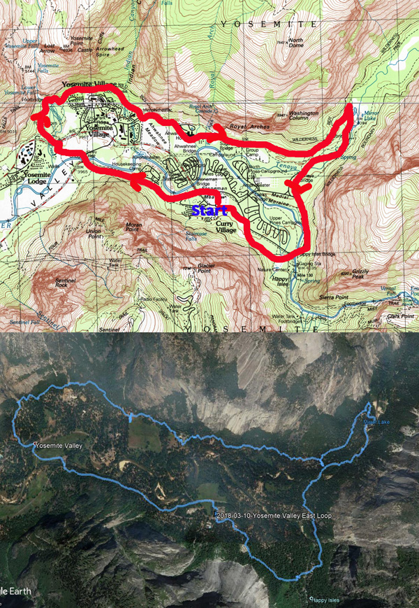
Hike Info:
Type: Hiking
Trail: Valley Loop Trail
Destination: Loop
Distance: 8.74 miles
Start Time: 9:37
End Time: 3:01
Travel Time: 5:24 (1.62 mph)
Moving Time: 3:41 (2.37 mph)
Elevation Rise: 958'1
Descent: 871‘
Maximum Elevation: 4,241'

1I have some doubts about these figures. On a FitBit, one person recorded 650’
of climb, another recorded 550’ on a SmartPhone tracking device.
 |
| Yosemite Falls from Stoneman Meadow |
This is a Meetup
hike, but with the idea which Sherri and I are getting ready to walk
the half marathon at the California
Classic.
The idea is that each week leading up to the half marathon on April
8th, we will go on longer and faster hikes. So the schedule is to do
the loop around the eastern Yosemite
Valley.
But, the week before, the
weather forecast ranged from rain to snow to sun and back to rain. So
there is some concern about the weather for the hike. On the morning
the of the hike? The forecast is for a good amount of rain with a
light rain starting at 11am.
 |
| Sherri, Oz and Half Dome |
 |
| Oz and Half Dome At Sentinel Bridge |
We get to Camp Curry at 9:30 and start walking soon afterwards. We quickly get the benefits of going clockwise as we get good views of Half Dome and Yosemite Falls-Stoneman Meadow has such good views. Then we pass by the employee housing, The first mile or so is paved for bicycles. When we get to Sentinel Bridge, we cut over towards Yosemite Falls. But not before stopping at this huge granite boulder. What is so special about the boulder? There are a couple of iron rings planted in here. The question is, why? But we also talk a bit about the old village which used to be around here.
 |
| Map of Old Yosemite Village from Eldon Grupp |
 |
| Yosemite Falls |
Then it is time to cross Cook’s Meadow on the way to Yosemite Falls. Of course, I cannot help but to talk a bit about the hotel which used to be here. A sign already lets the group know about the use of the meadow. Then onwards to the Falls, with a brief stop at the bathrooms. When we do go over Yosemite Creek Bridge, it is time for another talk explaining that there are eight (now seven) historic bridges in Yosemite Valley on the National Historic Landmark Registry.
 |
| Gary, the Tour Guide |
| Lost Arrow |
This part of the loop goes about a hundred feet above the current Yosemite Visitor Center and along the northern wall. We meet a couple from Visalia along this section, exchanging greetings. While in most places, there are too many trees for a good view-strange complaint isn’t it-we do get glimpses of the Valley floor. Still it is enjoyable, even though I huff and puff a bit. After the stretch, we come down the trail into the Ahwahnee Meadow area. There is all the luxury you would want on a hike and for lunch: picnic tables and flush toilets. You got to admit, Life is Good!
After we finish lunch-mine the
traditional sandwich of the Duran’s, we continue on. Nobody was
interested in going into the Ahwahnee Hotel, so we continue on
towards Mirror Lake. The tricklets we see on the Royal
Arches
combines up into a nice little creek which we are thankful for stones
placed strategically along the trail for a dry crossing. Earlier I
had talked about Indian
Canyon
and the escape routes which the Native Americans had to escape the
Army. The other place is the Indian
Caves
close to the foot of Washington
Column.
 |
| Mirror Lake Ice |
 |
| Mt Watkins and Ahwiyah Pt |
 |
| Ahwiyah Pt and Half Dome |
After that, it is, easy walking until we reach the bathroom at the foot of the Mirror Lake grade. We stop for a break here. A group from Notre Dame comes by and we talk with them for a while. They are part of a group going on to the Bay Area to study entrepreneurialism.
We say goodbye to them and
continue on the stable trail to Mirror Lake. I do a bit more huffing
and puffing. Because the area is pretty sheltered, snow has stayed on
the trail, which in itself, is not too bad. But since we are going up
and down a small ridge, there are these rock steps which the packed
snow makes a bit more dicey. But we all get over it and drop into
Mirror Lake.
Now for decision time. Do we
go around Mirror Lake? Or just return down the road and meet the
trail at the bottom? After consideration, we felt we were being
fortunate with the rain not falling, why chance being stuck 45
minutes away from any shelter? We meet the Notre Dame group again and
get a chance to talk with a couple from the group. We share
different parks which we have been too. Acadia
National Park
gets added to the bucket list.
So down the road we go. But not before taking many pictures of places like Mt Watkins and Half Dome reflecting in the Lake. Some beautiful reflections of the walls of Tenaya Canyon. The trail and then road down is non-eventful. When we get to Tenaya Creek Bridge, we leave the road and rejoin the Valley Loop Trail. This takes us just off the road on the most eastern side of the Valley. Few people use this trail, even though we are passed by a trail runner. Soon we come to Happy Isles, and its bridge. We take the last bathroom break of the day before heading on the backside of the area. There is a trail which goes to the backpacker’s parking lot. This is all covered with snow, so it makes a bit of a slower pace. Also we feel a few drops as we go along. Then it is off to our car.
 |
| Hidden Half Dome |

Trail Lesson:
Leadership
in a hike consists of convincing people that where you are taking
them is where they want to go. (Actually, what was said was a lot
better, but cannot think of what was said then.)
Background
Historical Bridges of Yosemite Valley
- Yosemite Creek Bridge
- Ahwahnee Bridge
- Clark Bridge
- Pohono Bridge
- Sugar Pine Bridge
- Tenaya Creek Bridge
- Happy Isles Bridge
- Stoneman Bridge
Extra Photo's
 |
| Lower Yosemite Falls |
 |
| Yosemite Falls From Cooks Meadow |
 |
| Yosemite Falls |
 |
| Mt Watkins and Mirror Lake |
 |
| Gary in thought |
No comments:
Post a Comment