Monday, April 14, 2014

April 14, 2014 - Redwood Canyon via Sugar Bowl Grove

Title: April 14, 2014 - Redwood Canyon via Sugar Bowl Grove
Trail head: Redwood Saddle
Hike Info:
Type:  Backpacking
Trail:  Sugar Bowl Grove Trail
Destination: Redwood Canyon
Distance: 5.24 miles
Start Time:  11:31
End Time:     3:41
Travel Time: 4:09 (1.26  mph)
Moving Time: 2:27 (2.14 mph)
Elevation Rise: 962'
Maximum Elevation: 6,928'
Description:
Despite starting close to when we wanted to start, we are getting a late start of 11:30. Jerry J, Steven, Sherri and I left Fresno a little after 8:30. We were merrily going along until Sherri says, were we stopping at Subway? So off we go to Reedley to find a Subway for our lunch and dinner. We then head out Hill Valley Road to meet Highway 180 close to Squaw Valley.picked up the Wilderness Permit at Grant Grove went to the trail head at a Redwood Saddle.
Sherri, Gary, Steven and Jerry at start
But we are not finish with our slow start. We were putting on our packs when Sherri reached into her pocket and pull out a goob of lotion. The lid has come off her sunscreen messing up her pocket, her inhaler an other stuff. But we got things mostly cleaned up and we are ready to start.
Today we will go up towards the Sugar Bowl Grove and then drop into the canyon. The first two miles we ascend up what I think is Redwood Mountain but I cannot find that name on the map. But we go up about 800' from the car during this climb. It is good looking across the canyon to see Buena Vista Peak and Big Baldy. There are some vistas, but you when you do get a chance to see, it is worthwhile stopping to gawk and catch ones breath. 
Walking in the redwoods
Around the two mile mark we start coming down. But we first stop for lunch, with a view and enjoy those Subway sandwiches. Not only do we get to enjoy the view, but we are surrounded by Sequoias. Sugar Bowl Grove is reported to have 50+ sequoias in the groves acre. Then we start our 1500' descent. Our pace makes a noticeable improvement. I lag behind, pondering the redwoods I see below, as well as taking some pictures. When I do lag behind, I easily catch up, which makes me feel good. 
Results of controlled burn


The tops of the sequoias always invoke a sense of being a crown on the king of the forest. We go down as these majestic trees ascend. These trees which were here long before I came will be here after I leave.


Big Baldy

Edge of Sugar Bowl Grove

Jerry contemplating the view


Once down to the canyon floor, it is a short distance to the Hart Tree Trail junction and the area where we will camp. There is a nice place there, but it is right on the trail and bit too much traffic for my tastes. So I scout out places, but do not see anyplace obvious. So I go down the canyon, maybe an eighth of a mile and find a good place, maybe not as nice as the first one, but still good. So we camp there.we have our tent; Steven his hammock; and Jerry his new tent. His tent looks ok and should keep him warm tonight.
Tops of trees
We lounge around camp, enjoying the sunlight and the warmth. Jerry, Sherri and I go for a small wander about, visiting the Sequoia's. It is much different than the more popular groves. Here you can come and touch these long-last trees. I do not think Tolkein thought of these trees with his Ents, but they are what I think Ents would look like.
We come back and have the rest of our Subway sandwich and play games-Hearts and Clubs. Then with the light fading and the coolness creeping we decide it is a night. Jerry J did pretty well today. I think he knew he had more than a day pack on, but looked like he enjoyed himself.


Wednesday, April 9, 2014

April 9, 2014 - Rim Trail and Back to Foresta


Title: April 9, 2014 - Rim Trail and Back to Foresta
Trail head: Cascade Creek
Hike Info:
Type:  Hiking
Trail: Old Big Oak Flat Road and the North Rim Trail
Destination: El Capitan
Actual Destination: Ribbon Meadow
Distance: 7.54 miles
Start Time:  8:08
End Time:   1:21
Travel Time: 5:12 (1.45 mph)
Moving Time: 4:25 (1.71 mph)
Elevation Rise: 2,256'
Maximum Elevation: 7,791'

Cascade Creek

Description:
At end of Trip
I woke up cold and I had slept cold last night. But I do not think it got too much below freezing. Usually I sleep pretty snug, but last night with my new sleeping bag, I definitely did not sleep well. So when it became somewhat light, I got up and just walked around a bit. Went up and down the Old Big Oak Flat Road. Not very far either way. The snow where we walked yesterday on the other side of the bridge had refrozen and the melted snow on the bridge had frozen. But on our side of the bridge, there was water trickling down from melted snow.

After awhile Andrea got up. We had our breakfast of oatmeal and stuff. Then off we went after telling Sherri, who was still warm in her bag that we were gone, and me going back to get fresh batteries for the GPS and camera. Oh yeah, the camera, had to go back and get that as well. Andrea could have committed me to an institution dealing with memory issues then.

Andrea's Good Side
But despite my mental capabilities, Andrea and I start off on our trek to El Capitan. If we make it, it will be a 16 mile day with our return trip to Foresta. The first half of a mile is down the Old Big Oak Flat Road until we hit the trail junction for the Rim Trail at Gentry Station, not that Gentry Station is there anymore, but it was at the site. Actually, looking at some old books, I think this is where a toll station for gentry's was.

  
Snow and Andrea

Anyway, we start up on the Rim Trail. The first quarter of a mile, not too bad. And then it goes up and up and up. Looked like in places there is a 24% grade. It is still cool, but we start to shed our outerwear. Glad I did not bring my jacket along. Even so, Andrea eventually puts my stuff into her pack. At 6,000' we start to hit patchy snow, mostly in the shade. We also get some views of the Cascade Creek drainage. 

I quickly realize that with Sherri not being with us, I am the weakest link. Not so much in being able to keep up the pace, but in being able to take a breath.  But I still do pretty well and Andrea patiently slows down for an old man. Early I had mentioned that I thought at 7,000' we would hit snow pretty continuously, and we do. Not deep, maybe about a foot or so, maybe two feet in the shade. Just enough to make us work at it. We cross the ridge at the top of our climb, about 500' above El Capitan.
Andrea at Ribbon Mdw

But it is getting to be elevenish an we still have over two miles to go. We get to Ribbon Meadow and see nothing but a field of snow. With our trip back, we decide that it is time to turn around and head back to camp. But first, we rest and take in some energy bars at Ribbon Meadow. The sun feels good enough to stay here for a long time, which we do. But reluctantly we get up and head back down the trail we came up.

Andrea and Gary on morning hike
Our trip back to camp is a lot quicker and easier--most of it downhill. But we do realize how steep we came up as we walk down. My legs are starting to feel the deadness which the climb induced. Andrea, who did a half-marathon a couple of weeks again, still looks strong. Even with the faster pace, there is delight in looking around and seeing the west end of Yosemite Valley and Cascade Creek area. I will say the last little bit from Gentry's to our camp showed how much the climb took out of me. Even though we go up maybe 150', the legs were aching. I was glad to get back to camp and sit for a bit. Also having lunch there was not bad either.


Hike Info:
Type:  Backpacking
Trail:  Foresta to Cascade Creek
Destination: Foresta
Distance: 4.00 miles
Start Time:  2:28
End Time:   5:00
Travel Time: 2:31 (1.59 mph)
Moving Time: 1:55 (2.09  mph)
Elevation Rise: 363'
Maximum Elevation: 6,149'


Description:
After lunch, we retrace our steps from yesterday. We are returning back to the car. Seems a bit cooler than yesterday-whether it is an illusion or reality, I am not too concerned with. We will be going through the part where we felt it was hot yesterday.
Stream Crossing

We pretty much walked the trail non-stop, with the exception of the Tamarack Creek crossing. Sherri and I took off our boots, while Andrea decided to do some gymnastics with a log and some rocks and made it across--even with her pack on today.

The difference between yesterday and today is that we have a perspective of traveling in reverse. Instead of heading towards the Valley, we get to see the burn area in front of us. There is a sense of ghostly beauty to it. The burnt out hulks of trees standing upright; the shrubs just starting to come back again. The demarcation after Wildcat between burn and green is startling-where before it was going from the heat to refreshment; today it is going from a friendly world to something of a deadscape-but not quite dead.
Andrea

We are glad to get back to the car. After discussing plans, we realize that we all are tired. Andrea has a three hour drive back to the Bay Area; we have two and half hours. So we part ways. It has been a joy to hike with Andrea this past couple of days. We stop at Todd's in Oakhurst before reaching home around 8pm.


Bridalveil

Gary and Andrea hiking

Ragwort?

The Dance Hall


Snow Plant
Sherri and Andrea

Tuesday, April 8, 2014

April 8, 2014 - Cascade Creek

Title: April 8,2014 - Cascade Creek
Trail head: Foresta
Hike Info:
Type:  /Backpacking
Trail: Parts of Rim Trail
Destination: Cascade Creek
Distance:  4.65 miles
Start Time:  11:31
End Time:     3:46
Travel Time: 4:14 (1.10 mph)
Moving Time: 2:50 (1.64 mph)
Elevation Rise:  1,709'
Maximum Elevation: 6,144'
Description:

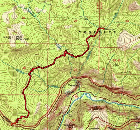
We started out planning this hike to take people who have not been backpacking before. But things did not work out, so the remaining sojourners are Andrea, Sherri, and myself. But that is good too because we get to spend time with our daughter.  The other change in plans was the location. Almost no snow all winter. But last week a couple of feet dumped in the Sierra's-which is a good thing. But our original destination up Alder Creek has more snow than I want to camp in. For years I had been eyeballing a trail out of Foresta. This is not a summer-time trail as there is a lot of exposure to a sun. Even today with it being 90 in Fresno, it will be warm on the first part.
On the way up to meet Andrea, we had an incident. We stopped in Oakhurst to pick up a Subway sandwich, which by the way, we have had good success in stopping here. This time is no different. But when I open up the bear canister to put the sandwiches in, a strong scent of wine, along with a bit of light purple appeared. Our wine bag had sprung a leak. Lots of stuff in the canister was wet and some of it leaked onto my shirt and pack. After using the Subway bathroom to clean up the mess-thanks Subway-we were able to leave. At the entrance station we examined the pack. We just needed to clean up a bit more, but most everything, except for the pack had not been affected. So we are off to meet Andrea.
We got to the trail-head a little after 11, over an hour late. Andrea had gotten here at 9, so she has had a long wait. The first order of business is to repack my backpack after making sure there was nothing affected by the wine flood of 2014. Then we are off, around 11:30.
Dead Forest
Tamarack Falls
After crossing the road, we started our climb. While today is warm, this trail could have been a lot hotter. We sweat a lot-some of it gets into my eyes. But we continue on up this initial climb. The A-Rock fire1 of 1990 came through this area and the area is still recovering (since writing this, I found out that a fire came through in 2009). For the first miles, there are only burnt tree trunks still standing. There is old dried up manzanita bushes which show some signs of life-that is besides the grasses and a few wildflowers. Maybe as compensation, we see some falls by Tamarack Creek in the distance.
After a mile and a half of this, being under the noon sun, we see the first signs of forests, firs it looked like with some incense cedars. Wildcat Creek is close by. We see the Dance Hall and the Devil's Dance Floor at the end of Wildcat. Now this trail is looking a bit more like a Sierra trail. After crossing Wildcat Creek, we stop for lunch. Not too bad of a place, just enjoying the mountain air to enjoy our Subway sandwiches.


Andrea&Gary after Tamarack Creek

Tamarack Creek


Enjoying the hike
But now it is onward. We have down the major part of our climb so it is more of a relaxed pace. With us being under the trees, the walking is nice, the uphill is moderate, conversation flows freely, but being the afternoon, we are a bit warm. But that changes in a few minutes. Except for the slope of the hillside, you would not realize you are just a quarter-mile above some of the falls of Yosemite-not the famous ones, but the ones Wildcat, Tamarack and Cascade Creeks create.


Sherri
But this comes to an end-not the conversation or steep hillside, but the warmth. We need to cross Tamarack Creek. As much as we scout around for a place to cross, Andrea only finds a suitable place to cross-without her pack. Sherri and I take off our boots and wade across. That snow-fed creek is COLD! Certainly no thought about how warm the air is. We get dried off and start on our way again. Now it is less than a mile to Cascade Creek. I am a bit concerned about crossing this creek, just because of its size and I think I have read in a blog how this guy had to travel a ways to find a way around it.

Cascade Creek
But we come to Cascade and find a bridge, and snow. It is getting later in the afternoon. A bit too soon to stop. But looking at the map the next water is four miles away after a pretty good climb. Also this snow is spooking me so I think it is better to camp here. There is a nice spot to stay, with a good fire pit, close to the creek. So camp we do.


Wanderings
After pitching the tent and looking around a bit, we go for a short wander up towards Tamarack Flat along an old road. It turns out this is part of the historic Old Big Oak Flat Road. We do not get very far, maybe a third of a mile when we are stopped once again by Tamarack Creek. With snow all around it, we decide to cross it, but to head a bit towards Cascade Creek on our way down. Just wandering, nothing spectacular.


Sherri, Andrea, Gary enjoying the fires
Dinner is the other half of our Subway sandwich. Andrea brings along split pea soup, which tastes good warm. A fire is started and the evening air turns chilly with the setting of the sun. We wait until we can see stars--well I do not wait, but fall asleep while seated by the fire. But it is nice just being here, enjoying the companionship of wife and daughter.

Hike Info:
Type:  Hiking
Trail: Tamarack Flat Road and wandering
Destination: Cascade Creek
Distance: 1.12 miles
Start Time:   4:46
End Time:    5:39
Travel Time: 0:52 (1.29 mph)
Moving Time: 0:41 (1.64 mph)
Elevation Rise: 265'
Maximum Elevation: 6,261'

 1There are several interesting references to this fire. It appears that not only did A-Rock fire burn this area in 1990, but also the Big Meadow controlled burn in 2009. For more references, see the following links:


  • Tributary
    Falls along tributary


Saturday, March 29, 2014

March 29, 2014 - Marble Falls

 
Title: March 29, 2014 - Marble Falls
Trail head: Potwisha Campground
Hike Info:
Type:  Hiking
Trail: Marble Falls
Destination: Marble Falls
Distance:  6.75 miles
Start Time:  9:28
End Time:   3:00*
Travel Time: 5:31* (1.22 mph)
Moving Time: 4:37* (1.46 mph)
Elevation Rise: 1,583'
Maximum Elevation: 3,810'
*My GPS batteries died about a third of the way on the return trip. The mileage and elevation should be close, but the time is off.

Description:
We arrive at Kohl's at 7 and it is another long drive to Three Rivers. Like our two previous hikes, this destination is a first for us. So with that in mind, Nat and Jeffery pile into our car and we start out with about 18 other intrepid hikers for a location just outside of Ash Mountain. We stop in Farmersville for a break and hit Potwisha a little after 9.
Canal

The trail head is on the far side of the Potwisha Campground. The first part of the trail is a dirt road which goes besides a canal. Where this canal goes, John's conjecture is to Kaweah Reservoir. And that is a good guess. looking at a topo map, the canal skirts the campground, then crosses the road and the Middle Fork of the Kaweah. From there it meets up with a flume and heads towards the reservoir. Someplace in this area is a Parshall Flume. This may be to measure the river flow.  You can see pictures from 1955 at the Huntington Digital Library showing this flume. Now, what the use is it? I do not know. My speculation is it might be used for water for the campground and visitor center.  


Up the Marble Fork
About a quarter mile up the road is the official start of the trail. You make a right turn and start heading up a short series of steep switchbacks. This gets us up our first 150' and steps the tone for the next two miles. Fortunately, there are many places for the more thoughtful and philosophical minded person to stop and ponder what he sees-not being sexist here, just I am a he. "Shes" have equal opportunity to take advantage of being thoughtful and ponder any philosophical implications of this trail.

Back towards Three Rivers


Yucca Plant
Sherri and Admiration Point
While this is not a wildflower year, there are some redbuds out, along with the miner's lettuce sprouting their petite white flowers. Oh yes, and how can I forget the yucca plants, one of which is just about ready to bloom and stood higher than me! These are a pleasure to observe as we walk along. Today I pretty much stick with Sherri on the way up. And up we continue on, climbing pretty far above the Marble Fork of the Kaweah. The canyon this water is cutting is a steep V. On the other side of the canyon is Panorama Peak. Jerry K says that he and John want to take us-the group--up to another point, Admiration Point. This Point towers above Marble Falls with Switchback Peak between them on our side of the river. The trail calms down and continue a climb which does not seem as steep. But we may have just gotten used it. About 2/3's of a mile from the end of the trail, a couple of people have had enough and will wait until people start returning.


First Falls


But we continue on. I will say this trail is not one of NPS' better maintained trails. One place your get the fun of clinging to a rock and going from one ledge to another-this is not as bad as it sounds. Still for a popular trail, I am a bit surprised. At the end of the trail is another opportunity to climb up a rock about 5'. Here, you find a marble rock bowl which eon's of water has scoured out and is still working on. Several places around the falls have these scooped out bowls.

Middle Falls


Marble Falls themselves are really three sets of drops. The first is down the river about half of a mile and we saw them coming in. Then we are sitting on top of the middle set. Then according to the map, the falls actually labeled Marble Falls is about a third of mile and 400' up from where we are. 


We sit on top for about an hour, soaking in the sun and fellowship. I pass out some of my cookies. And this is where, as John and Cathey say, it is not a hike without a fall happens. I was really hoping the Falls would suffice for a fall. but alas, it was not meant to be. As I was sitting down on what I thought was flat rock, I rolled backwards. Legs going up, camera knocking off my glasses and my pride bruised. But everything else, including the cookies were intact. 

We then start back along the same trail, after all this is an in-and-out type of a hike. I manage to go out without falling. Someplace along the return trip, the batteries in my GPS gives out-I have extrapolated our mileage and elevation from our incoming trip. A bonus is that one of the new people in our group is starting to train to climb Mt Whitney this summer. I talked with her for a most of the way down. At least on my end, it was a pleasant conversation and it made the walk back go fast. She actually did pretty good coming back and we got to wait about 15 minutes for the rest of the group to catch up with us.


Gary, the hiker
Our post hike meal was in Three Rivers at the Pizza Factory. Still enjoyable. Got back to Fresno before 6.