Title: March 13, 2021 - Davis Road
Hike Info : Description : Extra Photo's : Animals : Flowers and Plants
Trail head: Mill Creek Campground
Trail: Davis Road
Destination: Davis Flat
Distance: 8.70 miles1
Start Time: 10:02
End Time: 4:25
Travel Time: 6:23 (1.36 mph)
Moving Time: 5:12 (1.67 mph)
Elevation Rise: 1,350'
Descent: 1,343‘
Maximum Elevation: 2,085'
1I carried both of our GPS’: Garmin 60CSX and Foretex401. After adjusting a bit for the location wobbles when we were stationary, they both came out very close together. Rose’s phone registers a little above 9.5 miles

Gary at the start
Our first “real” hike in
awhile, even though it is on a road. We have Rose with us; Betty has
other obligations. But more important than me?
Even though it is less than 60 miles from our house, it is almost two hours of driving. So we meet at 8:00am and get on the road pretty quickly after that. We go through a maze of foothill roads until we reach Pine Flat Reservoir. Our destination is on the other side of Pine Flat at Mill Flat campground. We reach that at 9:50. The temp is 51o at the start. But the sun is shining on us, so I go down to a T-shirt and shorts. There is a feeling of coolness, not cold. A great feeling to hike with.
And now onward with our hike.
During the summer and fall when Sherri and I are in Delilah
Lookout
, the area seems so brown, dry and hot. But during the Winter and
early Spring, it is a magical wonderland full of emerald colored
hills, flowers and water flowing. This is Rose’s first time in the
area and we stop every couple of minutes to examine some new marvel,
such as a newly blossomed plant. The road will go gradually up for
the first two miles. But, not evenly, it is on a rolling incline. So
I am thankful for these small breaks to enjoy these mirific times.
Poppy Field
We shortly come to the first checkpoint: the unnamed creek, maybe about half a mile up the road. I told Rose this is a creek I have called Disappointment Creek, mostly because every time I have taken a picture of it I have been disappointed. But on the topo map there is no name so I can call it what I want. I think Rose is drawing the line on me calling a cement water drain a natural formation.

Rose and Sherri at "Disappointment Creek"
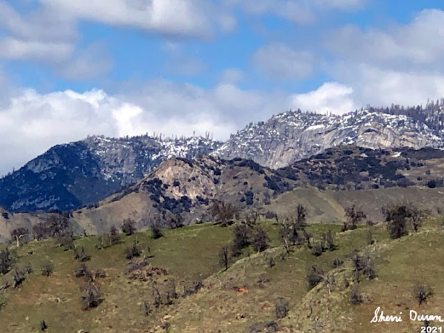
We continue to enjoy the emerald colored hills. But beyond them, we are seeing snow, looking like it starting around 3,000’. This is from a recent storm, so it may melt off quickly.
The road now turns east and we stop at Crabtree for a break time-it is way past elevenses. I devour a Clif bar; Sherri has an Access bar. Three bicyclists pass us-of course we chit-chat with them (Sherri might say it was more of a chinwag on my part. At least it could be a step up from pontificating.) They may be reaching their limits on hill climbing as this is their first outing.
Even though this is our first
hike of the season, we will not be stopping here. I figure another
hour and a half until we reach my turn-around time. This part of the
road, we start rising up really good. But the previous couple of
miles I think has loosened my muscles so we can even talk a bit while
doing this climb. Another bicyclist passes us-we see him a short ways
up chatting to the other three bicyclists. He will pass us again
later on.
Delilah Lookout from Davis Road
 |
| Davis Flat |
We now change to the Davis Creek drainage-definitely a smaller creek than Mill Flat Creek. Still there is beauty there. The creek is far beneath us allowing for us to get a good view to the north. Even though we go up pretty good, the creek rises faster. We go around a hill while the creek goes another way.
When we meet up again, the
creek is at our level. But there is something else which I start
looking for: Delilah
Lookout
and I found it! Today it seems a lot clearer than when I have seen it
before from this road. Also I know that we are close to Davis Flat.

Whose Pants?
This is good, because I really
would like to sit, eat and rest. You can probably guess why. We cross
Davis Creek and find the rocks we are familiar with. Time to enjoy
lunch, which we do. As we look around us, there is a pair of jeans
neatly laid out. The mystery, where are the legs which went into
these pants? I do wander to look at the old mine and the shack which
we have seen there before.
It is 2:00pm and now it is
time to head back, I am a bit stiff, but as I start walking, the
stiffness works out. I fall back as I stop and examine things and
even try taking a few pictures. Even with it being easier going down,
I fall behind Rose and Sherri. That is OK as I enjoy my time of
quiet. With my hiking I enjoy time of friendship, being among those
whom I care for. But I also enjoy walking through beauty with my own
thoughts and ponderings. On this hike I am getting both-I am blessed.
By the way, my thoughts are not great, just enjoying.

Rose and Sherri walking the road

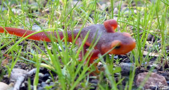
Gary in search of a newt
The bike who passed us earlier
comes down. We chat for a few minutes. He made it to the approach to
Goat
Saddle
before going through snow got to him. That is a pretty good journey
up-about a 2,000’ climb. He goes on and I catch up to Rose and
Sherri at Crabtree.
On our final 2+ miles, it is time for some wildlife. No not that kind. First we see a Sierra Newt. This time living. We have seen several dehydrated and squashed-not sure which happened first. Always fun to see them. Then a large bird is circling overhead. It might be an eagle. Or it could be a raven. To me it could be either. An eagle sounds so much better. Then another newt. When I get up from my picture taking, my shovel easily slides down between my underwear and skin. You do not know how thrilling that can be.
We end up at the car with it still being light, around 4:25. We say goodbye to Rose and head off with her following. It has been a good day, tiring though. When we get home after 6:30, Sherri goes out and gets what is becoming our traditional after hike meal, Habit Burger. When I lay down for a few minutes, the next thing I know, Sherri is waking me up to go to bed. I guess I really was tired.
Extra Photo's
 |
| Mill Flat Creek |

Davis Road a bit lower at start 
Looking north across the Kings 
Flowers at Gary's "Disappointment Creek" 
Looking towards Converse Mountain 
California Golden Poppies 
Poppies on a hillside 
Flower Photographers

Hills of green 
Hillside earth strata 
Entrance of Davis Mine 
Shack at Davis Flat 
Delilah Lookout 
Top of where Delilah Lookout sits 
Patterson Bluffs
Animals
Newts
 |
| Eagle or Raven |
Flowers and Plants
 |
| Lupine |
 |
| Phlox |
 |
| Wood Fern-down a canyon and across Davis Creek |
 |
| Mountain Monkey Flower |
 |
| Fern |
California Golden Poppy
 |
| Redbud |
Liveforever
Henderson Shooting Star
Baby Blue Eyes


No comments:
Post a Comment