Wednesday, November 19, 2014

November 18, 2014 - Trails Around Shaver Lake

Title: November 18, 2014 - Trails Around Shaver Lake
Trail head: Balsam Snow Park
Hike Info:
Type:  Hiking
Trail: Bear's Highway Trail, near Shaver Lake
Destination: North Fork Stevenson Creek
Actual Destination: Below the Creek
Distance: 2.55 miles 1
Start Time:  9:15
End Time:  11:22
Travel Time: 2:07 (1.21 mph)
Moving Time: 1:21 (1.89 mph)
Elevation Rise: 833'
Maximum Elevation: 6,785'
 1Two things made this longer. The first is  the GPS did not sync up and determine an accurate location for about a third of a mile. Second is that from Stevenson Creek, there was about .9 to .95 miles of tracking down a group of hikers which was going the wrong way. I think the actual mileage from the Balsam Snow park to the North Fork of Stevenson Creek was about 2 miles.
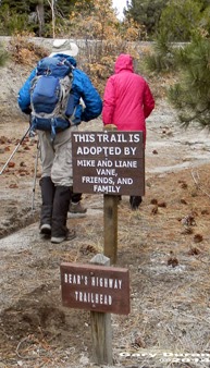
Trail Maintenance Crew
Description:
Another meetup hike. This one being lead by LiAne and a Jerry J. She lives in the area and will be showing us many of the trails she enjoys. But to add to the fun, it looks like we may get some rain today. So we show up at Kohl's at 7 and then are off with a full car load of people. But first our car needs to stop at home to pick up some medicine. We get up to Shaver Lake around 8:40 and meet LiAne there. From there, she takes us to the Balsam Snow Parking area for the first of our hikes. Along the way, these little flying white balls of frozen water start hitting my windshield. But this stuff seems to be more wind driven than falling: outside temperature is 42o.


Going down the trail
This first hike is relatively short-but we manage to make it a bit longer-more on that later. The Balsam Snow Parking area is a few miles above Shaver Lake. LiAne and her husband Mike maintain this trail, called the Bear's Highway Trail.  But the temperature is in the 40's. Pretty walkable. That will be the last of the moisture we feel until we finish our day and are safely in the cars.  The first third of a mile is a gradual downhill, along what looks like an old firebreak. Not too bad of walking.
Hikers and Scenery

Then comes the downhill part. Jerry K and I, being in back start muttering that this will be a real bear to go back up. It's steep and neither of us are looking forward to coming back up it. We descend about 600' in a half of mile. But there is some compensation for this: the area is just really good looking. The leaves are all a light tan with some gold and yellow mixed in. The trail itself does wander down, at least not straight down. We do come out into a rock overlook and Shaver Lake spreads out before us.


Shaver Lake and Tree

A few minutes later, we cut off the trail and head down a granite slab to the North Fork of Stevenson Creek. When it is warm, there will be a lot of pools to play in. But today, it is cold. Lee F has a probe and measures the water temperature as being 44 degrees-the air is 47. So definitely not a time to jump in.


North Fork of Stevenson Creek


 After milling around the pools for about 20 minutes. We come back up to the trail junction-where we left the trail. And this is where confusion reigns. We should go right and head back up the dreaded hill. But a group has taken off downward, as if we are heading to Shaver Lake. Lee F, Sherri and I catch up to a group who is wondering about the wisdom of continuing down. But others have leaped ahead of them. A couple of the forward group returns and after a discussion, Lee F and and I take off after the lone errant hiker. We send the rest back to the car.

Autumn Leaves

Lee and I wonder if there really is a hiker in front of us or not. But after awhile and looking at marks in the dirt, we decide there really is someone in front of us. Note to Gary: I need to get a lot better at tracking. After a half of a mile, we stop and whistle and shout. A returning call confirms that the hiker is below us. He returns and now for the 800' trudge back up the dreaded hill. I think I am the weak link in the three of us, but we each welcome our brief stops for breath and leg relief. 


Tire along trail

The last part of the trail runs right below Highway 168. We noticed a Subaru wheel complete with a strut laying 10' off the trail. There must be a story here. When we get to the group, we razz LiAne about the inadequacy of her trail cleanup-they really do a good job. She said she saw the wheel and that it has only been laying around about a week now.

But now on to further adventures.


Trail head: Balsam Snow Parking
Hike Info:
Type:  Hiking
Trail: Dogwood Trail
Destination: Ely Mountain
Actual Destination: Southern California Edison
Distance: 4.01 miles
Start Time:  11:28
End Time:     3:02
Travel Time: 3:34 (1.13  mph)
Moving Time: 2:11 (1.84 mph)
Elevation Rise: 585'
Maximum Elevation: 6,912'
Description:


 Now that we are all at Balsam Snow park, we head across Highway 168 and start walking down a dirt road towards Balsam Forebay. A short time later , there is a fork in the road and we spy the Forebay. Our section of the road veers left around the western part of the Forebay and then to the right before we observe a chain-link fence guarding the Forebay's dam. But being a keen observer, I note, it really is not designed to keep us out as there is a two foot gap under the fence where even I can crawl under.


Tractor in Buck Brush
A short ways later we see a caterpillar tractor ripping away buck brush. Later on, LiAne says that Southern Cal Edison does experimental programs to see how best to regenerate an environment. This is one of them. 

After following the road a ways, we veer off again, onto the Dogwood Trail. Many ducks line this trail and for the most part they are helpful. But this get Say, Jean and I into a discussion on why are ducks called  ducks?

Kaiser Peak in middle; Kerkoff Dome

But we are getting close to the top of Ely Mountain. I cannot say this is the best view ever. But when we descend a little down from there onto its western flanks, we do get to see Shaver Lake-if it was only full. Right now, it does look like it has a brown bathtub ring. We get to stop and enjoy things for about ten minutes.


Shaver Lake with bathtub ring


Now comes a fateful decision. There is a proposal: LiAne will return back the way we came and pick up her vehicle and drive around to the heliport. We will continue on for a short 20 minute walk down to the heliport.At least that is the plan and the start of the fun.

Are we really going down here?
I do not know where the trail went, but I do not think we followed it. I was in the back, so I was not really watching out for possible trail diversions-more watching to see where people went. Where we went was down the spine of Ely Mountain. The top of the spine consisted of several dome-like granite slabs, each being concave. Most of the time I enjoy walking down granite slopes, but today's granite had a fair amount of scree. So in some places you get the effect of trying to pick your way through a field of ball-bearings on a slope, while not falling. Sherri and I were pretty successful at this, but we know of one person who did fall and bent their pole.

This kind of slope is not Sherri's cup of tea, so we were rather slow in picking our way down this. By the time we got down this 700' granite field, we definitely were the last. But this had a bit of advantage. Most people, except for Lee J, Say and Jean had already scampered on and were coming back to say they could not find the trail. They wanted to go back up a ways. At this point, looking down, I thought I could find a route down. So off I went, crashing through the manzanita brush and down the hill side.

Sherri and Lee on the descent
Some people followed the way I was heading-actually Richard, Lee F, Sherri and I were the only ones who did. It turned out our team's way was relatively easy compared to others. We arrived at the heliport first. LiAne had already arrived a while back and was off looking for people. She came back with Jerry K. Slowly the rest of our group arrived and everybody was accounted for.
Sherri on the rocks

LiAne  drove us to retrieve our cars and then we all meet at LiAne 's place. She has opened her cabin for this group of sweaty people and prepared a nice after hike meal: chili beans, chipotle mix and minestrone soup. So good! We spend several hours at her place, just enjoying things before we realize we have a drive back. I vote that all after hike meals be held here.


Trail Lesson:
1) Good instructions to hikers helps make everybody know where they are going.
2) When going off-trail or cross-country, keep together. If not possible, split into distinct units.
3) Know where your path leads.


Duck Note:
North American trail marks are sometimes called "ducks" or "duckies", because they sometimes have a "beak" pointing in the direction of the route. The expression "two rocks do not make a duck" reminds hikers that just one rock resting upon another could be the result of accident or nature rather than intentional trail marking. From Wikipedia

The upside of ducks is that they are very easy to construct, and where used you are likely to find many of them. The downside of ducks is that they are very easy to construct and where used you are likely to find many of them. Because so little effort is involved in creating a duck, and because lost people seem to love to make them, they may not provide you the desired level of confidence. In fact, in some areas, they are more like graffiti than trail marker. From HowToWilderness
Hikers and Autumn Leaves

Looking down onto Stevenson Creek

Playing around the pools
Shaver Lake
Say, Jean and Lee J
Shaver Lake in Autumn


Wednesday, November 12, 2014

November 12, 2014 - Old Wawona Road (Ft Monroe)

Title: November 12, 2014 - Old Wawona Road (Ft Monroe)
Trail head: Bridalveil Falls Parking Lot
Hike Info:
Type:  Hiking
Trail: Old Wawona Road
Destination: Ft Monroe
Distance: 5.09 miles
Start Time:  10:32
End Time:     2:44
Travel Time: 4:09 (1.23 mph)
Moving Time: 2:44 (1.86 mph)
Elevation Rise: 1,413'
Maximum Elevation: 5,391'

Description:
Old Wawona Road
A Wednesday without a meetup hike. How novel. But we did join with our friend Rose for a day in Yosemite. Around 8 we picked up Rose and went on up to Yosemite Valley. It was time to buy our annual permits-maybe for the last time since next year we turn 62. But it goes to our parks so that is not a bad thing. We arrive at the Bridalveil Falls parking lot a little before 10:30. Actually we park about a quarter mile up from the parking lot, just a 100' from the W1 milepost. 
Old Wawona Road
Across from us we see the remnants of the Old Wawona Road. There are some branches and boulders across the road's entrance. The road has a nice grade up, not too bad, but enough to let you know you are walking up. We quickly slip to a forested area and see the numinous of Autumn in the golden and red leaves around us. Between the yellowing leaves of the dogwoods to the occasional reds in the maples, we are confronted by color, the color of the earth turning to rest.
Then we pass both Meadow and Artist Creeks before coming to Artist Point. Those old artists had the right idea. The view is just so good. Of course, we stop and gawk and take pictures. But there is more than just a mile and a half of walking today. We shortly get to the junction with the Pohono Trail going to Inspiration Point. But our route continues along the gentler Old Wawona Road. While the scenery is good, it is not classic Yosemite Valley view, but the road is enjoyable.
Artist Point View
Artist Point View


I should have described the Old Wawona Road before now. The road itself used to be paved. But over time, the asphalt has worn look. In places you think a car, a small car, could still drive it it-only for a very short way. Then the pavement gives way to where water has worn small gullies to rock. Or a tree has fallen across our path-this is an unmaintained trail after all. Rocks have fallen on the pavement. But the road is very walkable. You just need to be able to pick up your feet.
We hit a couple switchbacks which raises up a a couple hundred feet and brings us to a shoulder and view across the Valley, or gorge at this location. We see the Fireplace Bluffs and the Cascade drainage.  In this clearing we think stood Ft Monroe, our destination. There is a 3" pipe coming out of the ground close by and it matches a slide we saw on a Tony Krizan slide. We did not realize this was the place until after we left. But about 75' away, there should have been a garbage dump. We will need to come back another day to do a closer examination.
Instead we continue on the Old Wawona Road. This part for the next third of a mile is a bit overgrown. One large fallen log forces us to circumnavigate it, but the going is still pretty easy. A bit a ways we come up over a small ridge and are greeted by a group of college students playing Frisbee. How did they get here? We quickly realize we have come up on the back of New Inspiration Point. This is a lot easier than charging straight up the hill to it.
Inspiration Point
Not only is it easier, but as we wander around, we come to a ledge which has been used as a campsite. And what a campsite this would make! The view from a tent in the morning would be spectacular. Sun rising over Half Dome, sunset colors playing on El Capitan. Just thinking about it makes me want to camp there now. Instead, we ate lunch and enjoyed what we saw.
Instead of returning back via the road, we of follow the trail down to the Old Wawona Road. It is steep. But there is one more view we gather in before hitting the road. It rivals our lunch view, but I give the lunch view an edge on beauty. We follow the Old Wawona Road back down, stopping again at Artist Point.here we see the difference of morning and afternoon lighting the Yosemite walls.
Artist Point of View
We get back to the car around 2:45pm. Then head back to Fresno. But first we stop in Oakhurst at Remiers for ice cream. After all, it was too early for dinner and we needed something to reward us. A good day and a good hike.
At Inspiration Point: Sherri, Rose, Gary

Gary and Rose

Sherri
Rose and Sherri


Rose and Sherri returning

Old Inspiration Point
Inspiration Point
Inspiration Point

Wednesday, October 29, 2014

October 29, 2014 - Yosemite Valley West

Title: October 29, 2014 - Yosemite Valley West
Trail head: Valley Chapel
Hike Info:
Type:  Hiking
Trail: Valley Loop
Destination: Complete Loop from Valley Chapel to Pohono Bridge to Yosemite Falls and back
Distance:  12.23 miles 1
Start Time: 9:521
End Time:  16:06
Travel Time: 6:13 (1.97 mph)
Moving Time: 5:32 (2.21 mph)
Elevation Rise: 1,670'
Maximum Elevation: 4,164'
 1The mileage and time is a bit understated. The first quarter to a third of a mile the GPS did not pick up a signal. Also by its nature a GPS has a certain amount of inaccuracies which I try to compensate for. Another GPS on the trip obtained a reading of 12.8 miles. On a previous trip, I had a reading of 12.48 miles.

Jerry, Carly, and Eli
Description:
This is the complement of the trail I hiked on Saturday, Oct 18th. Instead of heading towards Happy Isles and Mirror Lake, we go westward to Bridalveil Falls, the Pohono Bridge and El Capitan. It is a good hike to do in the Fall when the dogwoods, maples and cottonwoods are turning colors. We have done this same hike the past coupe of years and it has become our favorite Fall hike. This is my first hike as a meetup organizer. So we shall see how things are at the end of the day.
Gary back to pontificating
 At 6:40, I got to Kohl's where we are gathering. First ones there. Amazing! People started coming in and all had arrived by 7. So we were able to leave by 7:05. I think that is a record for any meetup hike I have been on. Then it us up to Starbucks in Oakhurst. We meet Sonya, Jerry, Carly and Eli there and are away by 8:15. I am looking at the coordinates on my car's GPS for remnants of the Old Wawona Road. Don't think I found anything so I will need to go back and piece everything together. But we do get to the Valley Chapel at 9:30. We are 17 adults plus Eli, Jerry K's two-year old grandson. It will be a good group.
Autumn along the trail


The excitement of our hike starts even before our feet hit the trail. A coyote pays us a visit. It seems unperturbed by our group, that is until some of us turn a camera lens on him. He turns camera shy and trots off. 

We start out at 9:45 with the trail right in back of the Valley Chapel. We quickly turn west and get a fine view of the Cathedral Rocks through a break in the trees. The weather is cool-I start with my pants legs and a SmartWool shirt on. I hike with Eli, his grandfather and his mother. It is fun watching him walk along this gentle path. He experiences this path for the first time.
Gary on the trail


As I mentioned, the air is brisk, but the skies are clear allowing us to enjoy the Valley experience the best. Almost all of this trail is a gradual down or gradual up.  On the average, less than a hundred feet of gain or loss a mile. As we pass along the south side of the Valley walls, semi-paved path is an easy walk, mostly sandy gravel or pine needle covered. Pine trees line the side with a few broad-leaves, such as dogwood. Just a most excellent time to walk.

As we come close to Cathedral Rocks, the trail does grow more rocky and we experience an incline. This is said sort of tongue in cheek as it is only an incline of maybe 150'. Still when a 2 year old is doing it, I had better buck up and look strong. We all look at the climber's routes up to the Rocks. Each of us says that those routes are not for us, but evidently this is right up Carly's husbands alley.

El Capitan
Our first rest stop happens at Bridalveil Falls parking lot. I think this is rated as the smelliest outhouse on our trail today. Most of us gather a safe distance away from the outhouse. This parking lot is where I almost always lose the trail. While today I did not lose the trail-I knew right where it was-I just did not want to go through a tangle of thorn-covered vines to regain the trail. So we walk an eighth of a mile along the roadway where we find good access to the trail. From here, we walk along the Merced. Most of the time this river is rushing long its long journey to the ocean. But today, it is pretty laid-back. We see the reflection of the trees and rocks in the shallows. This is what the end of year will do to a mighty river, particularly the third year of a drought.

Our Path


Around noon, we round the west side of the Valley on the Pohono trail. I really like the section we just passed through, between Bridalveil and Pohono. The trees drape over the trail, the river flowing beside us, the colors and reflections are there for me to enjoy. Just so good to be alive and experiencing all which God gives us during this season.
Merced River
  

But now we are past noon and it is time for lunch. We go along on the return trip. With the afternoon sun, while not hot, the shadows have disappeared under the more direct light. Still there are the Fall leaves still being attractive. The pace is still good and conversations still flow-a good sign that people are still enjoying the hike and it has not become a trudge.


El Capitan
Climber Tent suspended in space
Under El Capitan, we stop for lunch. Most of us take up the time-honored occupation: watching for climbers. Sure enough, there is one party going up the west side, under a heart-shaped overhead.  Later on some of us will see a tent hanging from the east side of the nose. In the meantime, I am learning a secret to being a good organizer: cookies! I brought some Golden M&M Bar cookies and Black Cat cookies. They were enjoyed. Long time ago Sherri and I learned that a well fed group is a content group.


Sentinel Rocks, not Dome
With two-thirds of the trail behind us, we still need to continue on. Now our eyes are focused on the big rocks of Yosemite: El Capitan, Half Dome, the Three Brothers, Glacier Point, and on and on and on.  Seeing them is always awe-inspiring. Makes me feel so privileged to live so close to this beauty. Even with the grass golden, not green, Yosemite has a magical air to it.

Now that we are under a mile of Yosemite Falls, we are seeing people-something which we have only seen around the parking lots and road. Sort of jarring to have voices besides our own. Still, it is not nearly as much as it would have been just a month ago. We cross Northside Drive again and come to the Native American exhibit area. We see a couple TeePee's on the hill side and where they are building a roundhouse. Then we come to Camp 4-where most of the great climbs of the Valley started out from. It is always a good thing to breath that air. But we do notice a few campers giving us side-glances: Are they thinking what is this trail rift-raft doing here? We only stop to use the bathroom and enjoy watching someone climbing a large boulder.


Fawn in meadow
Now it is off again and we shortly come to the Yosemite Falls area-no Falls today so we fore go the side trip and cross back over for the final leg back to the Chapel. Some sharp-sighted people in our group spot some deer in Cooks Meadow. Then we head over Sentinel Bridge and finally into the Chapel parking lot.

So good to be back after 12 1/2 miles. All hikers accounted for and there is even smiles on faces-so I think I have passed the first test of being a meetup organizer. About half the group needs to be getting back home so they take off. But we stop at Todds in Oakhurst. Not only do we get good food, but we even get to  root for the Giants in the World Series. What a day! Sherri and I get home at 7:30.


Half Dome

Trail Lesson:
A well fed group is a content group.

Autumn and Cathedral Rocks

Autumn Trees
Gary on trail

El Capitan
Merced River