Sunday, February 24, 2019

February 24, 2019 - Corrine Lake


Title: February 24, 2019 - Corrine Lake
Hike Info : Description :   Extra Photo's 


Trail head: Corrine Lake Road
Hike Info:
Type: Hiking
Trail: Corrine Lake Road
Destination: Corrine Lake
Distance:  6.07 miles
Start Time: 12:53
End Time:     3:34
Travel Time:  2:41 (2.26 mph)
Moving Time:  2:09 (2.83 mph)
Elevation Rise:  705'  1
Descent: 712‘
Maximum Elevation: 2,541'
  1The GPS did not register the elevation. The elevation information is from Google Earth.
Description:
Sherri’s and mine first time organizing a Meetup hike since April. So I am a bit apprehensive about doing this event. The route is not an issue-just follow a dirt road. But just doing this. Fortunately it is a small group whom I have hiked with most of them before.
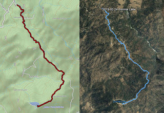
Our path
We go to church, then get ready. We leave our house at 11:05 and get to the parking lot at 11:20. Lori is waiting for us. John, Tom and Daniel shortly afterwards. We wait until 11:40 before leaving-missing one person. The trip up to the trailhead was pretty quick, about an hour. We see Pam parked at the Road 222 and Corrine Lake Road-she had gone up and down the road to Corrine Lake. She wants to only walk the road again, not drive it. A little while later Daniel drives up-he has gone all the way down the road aways. We are missing one other person, but Pam says that that person is not coming because their dog ended up in Emergency. I should say we have four dogs on this hike. They pretty much are well behaved.
It is approaching 1:00pm and we are all ready to move on. The weather is clear and crisp, just right to start walking. We follow a flume along-this flume comes from ManzanitaLake and feeds the PG&E lake we are going to. We will follow it pretty much all the way. Sometimes it hides in the hills or decides to meander away, but it will always come back to us.

North looking

But the meandering is part of the fun of this walk. Green hills, blue skies with a background of white mountains. Good hiking eye candy. Sherri, Pam and I sort of lag behind everybody. On my part, it is comfortable walking. The rolling hills do not seem to tax me too much, unlike a few previous hikes I went on this year.
Most of the way is on dirt road with ranch houses towards the side. I think there is forest service land around us as well. Soon we come to a gate with pavement. This seems like it is PG&E land. The dirt road is a bit easier on the legs, but the paved is still pretty good. The water seems to be moving faster-probably an optical illusion. But we turn a corner and head the quarter mile more to the lake. I make a pit stop at the outhouse by the power station, then join the group at the lake.
Flume
Corrine Lake is small, maybe just slightly larger than a pond. While easy to get to, we are the only ones there today. Nice to spend a few minutes relaxing by the lake, looking out at the snow covered mountains-actually the snow is a lot closer, maybe at the 4,000’ elevation or lower. Restful. Evidently, not all that restful as Pam, Daniel, Tom and John decide to walk around the lake with the dogs.

By the time they get back, it is time to start heading back to the cars. We retreat down the same road we came in on. This time, I am walking with John, Tom and Daniel. Not a fast walk, but one which I can sustain. We talk about different things. Along the way, we admire the work of over-achieving woodpeckers on some fence posts-sorry no pictures. The walk back is just as pleasant as going out.
Bass Lake and ice

We get back to the cars around 3:30. Usually it is a time for an after hike meal. But the only place I know of in North Fork is closed on Sundays. So we all congratulate each other on a good hike and head off towards home.
Well not all of us. Sherri would like to see the iced over Bass Lake, so we go through North Fork and come to Bass Lake through the back way. The northern part of Bass Lake has ice on it. Definitely do not want to be out with skates on the feet-even if I could ice skate. We decide to have dinner in Oakhurst. We choose El Cid and get stuffed. Now it is time to head back to Fresno.


Extra Photo's


View to the east

 
Southwest looking


More snow covered mountains


Boots and water

Still more snow

 
Flume

 
More of the flume


Bass Lake


Thursday, February 7, 2019

February 7, 2019 - Little Yosemite


Title: February 7, 2019 - Little Yosemite
Hike Info : DescriptionExtra Photo's : Animals 
Hike Info:

Type: Hiking
Trail: Canyon View Trail, Geary Road
Destination: Little Yosemite
Distance:  5.06 miles 1
Start Time:  10:15
End Time:      2:18
Elevation Rise:  1,329'
Descent: 1,329‘
Maximum Elevation: 854'
GPS Tracks
 1The GPS was not working properly. There was no track for the first mile and a half. Also the elevation never showed up. The mileage and elevation is based upon Google Earth’s calculations. The times are my approximate start and stop times.

Description:
Not that Little Yosemite! Last year we discovered another Little Yosemite. This one is in the Sunol Wilderness. While it is not as spectacular as the Yosemite, it is a pleasant find.
We were to go backpacking Thursday and Friday but between the predictions of rain for Friday and appointments scheduled, we decided to do a day hike. Andrea suggested going to Little Yosemite. Sounds about right. But we discovered that we had two different trails in mind. We shall see how we do about which to go on. Her’s is a 7+ mile look of over a thousand feet gain. Mine is 5+ with about 600+ of gain. With how I have been lately, I have some serious qualms of the longer more strenuous trail.
Crossing the Alamedda
We plan to get to the parking lot around 10:00. But we were both a few minutes late. The visitor center is closed, so after taking care of a few things we head out. We cross over the green and then cross a bridge over Alameda Creek. We come to the start of the Canyon View Trail.
The first quarter mile is pretty easy, then we start our climb. The thing about these trails in this Wilderness area is that there is little grading of the trails. So we just go up to the top of a ridge, then climb along its spine with maybe a short downhill and start it all over again. I make steady progress, but I am hoping that we are getting close to the top of the hill. My lungs particularly are being well used. The legs ache, but seem to be OK with the climb.


Cirrus Clouds

We get to the McCorkle Trail. This is about halfway to Little Yosemite. Now it gets easier as we are mostly going downhill. With the recent rains, the hills are all green with new grass. The air is clear and a few mountains a ways away are topped with a fresh coating of white. It is a good time to be out hiking.
Looking down into the Sunol area


We come to the spot where last April we joined this trail-can tell because of the fence. We know that right beneath us is Little Yosemite. But we decide to continue on the Canyon View Trail until it meets Camp Ohlone Road. Not much exciting to report, just pleasant walking-except we did venture off onto a cow path for a short distance.
The "W" Tree
There is a short, sharp descent into a small, unnamed creek bed. Only thing notable is that on each side of the trail is poison oak. We hit the Camp Ohlone Road and decide to continue on up it a ways. There is an interesting tree shaped like a “W”. So it is a little wonder that there is a sign saying the “W” Tree which is beside the “W” Tree Creek. After a half of a mile walking along the road, we come to a rock outcropping which Steven and Andrea climb. David and I walk a hundred yards farther and come to the other end of the McCorkle Trail. Also a trail marker indicates that we have almost come to the end of the park area. So we head back.

Little Yosemite
Walking down the road is a lot easier than before. I am able to even loiter and take a few pictures and then catch up. We stop at Little Yosemite and have lunch. I note that I am thinking of going back via the road. Some have talked about heading up to the McCorkle Trail and making that loop. But everybody decided to head back down the road.
Alameda Creek
I will admit the road is not very exciting. We meet a few people walking their dogs, also a few trucks which are servicing the project up at Calaveras Dam. But we walked pretty well, relaxed. Even a bit slow for me.
Around 2:00, we got back to the main part of the Sunol Park area and by 2:15 was back at the car. A pretty delightful family hike. Now to decide what to do.
Sherri’s cousin likes Niles Ice Cream Sweets and Eats. Sherri and I split a brownie sundae. Totally rich, totally enjoyable. I will say that I it did affect the tummy some-not that it was bad. But just caused me to feel a bit like I will never have to eat again. And this is with about eating only a third of the sundae. Enjoyable, but be careful is the moral of this story. Andrea is returning to Oakland and we go back to Mountain View. A good day.


Extra Photo's

Sign Post

Rest Stop-Sherri,, Andrea, David and Steven

Up a Hill-Steven, Andrea, Sherri, and David

Following the path-Steven, David, Gary
More Cirrus Clouds

Looking into Little Yosemite

Show on some far hills

Path goes ever onward-looking into Little Yosemite

Andrea and Steven on a rock outcropping
Peak 1,699'

Coming down the road into Little Yosemite-David, Andrea, Sherri and Steven

Entering Little Yosemite

More of Alameda Creek
Alameda Creek

What passes for a mammoth stone in this Little Yosemite

Alameda Creek
Steven and Andrea

Gary, Sherri, Steven and Andrea

Alameda Creek

The Brothers-David and Gary

Alameda creek


Animals
Vultures on high

More Vultures

Large Bird a quarter mile away

Downey Woodpecker and acorn

Downey Woodpecker