Showing posts with label Camp Curry. Show all posts

Thursday, April 30, 2026

April 30, 2026 - East Side of Yosemite Valley


Title: April 30, 2026 - East Side of Yosemite Valley
Hike Info : Description : Background : Extra Photo's : Flowers and Plants

Hike Info:

Type: Hiking 

Trail head: Camp Curry Parking Lot

Trail: Valley Loop

Destination: Loop

Distance:  5.83 miles 1

Start Time: 11:26

End Time:    4:10

Travel Time:  4:44  (1.23 mph)

Moving Time: 2:42   (2.16 mph)

Elevation Rise: 591 '

Descent: 595‘

Maximum Elevation: 4,072'

Minimum Elevation: 3,992'

GPS Tracks

 1The actual GPS track includes two times on the tram. I have removed those times from these figures.


Description:

Looking up the Merced from the Fens
I got up at 6:20 wondering if I was going to go on today’s hike in Yosemite Valley. Reason why I am unsure? Yesterday I had my COVID-19 vaccine. Usually this only leaves me with a sore arm. But last night I was really sore and tired.

Sherri comes in and wonders if I am going. I have a weak Yes. It will be just Sherri and I. We take off at 8:15 with me driving. It goes pretty smoothly until after Oakhusrt. Hazardous trees are being removed from along the side of the road. Looked like a guy is just about to fall one when we pass by. But this puts us behind a long line which plays into when we get to the entrance station. We get into a line which is about half an hour long, finally entering the Park at 9:40. Lesson learned is to start earlier. There is a stop at the Glacier Point Road. The lot is full with bicyclists as the road is closed to motorized traffic, but bikes are allowed. We finally get to Camp Curry’s parking lot at 11:05.


Gary, the Hiker
Our boots hit the dirt at 11:25. Our first stop will be Happy Isles. We walk to the backpacker’s parking lot, then take off on a trail which leads us away from the road, not that there is traffic on it. A backpacking couple with a foreign accent came upon us. We talk-they are heading up to Cloud’s Rest with the goal of Sunrise Creek tonight. That is adventuresome, particularly since they are starting around noon. But they are in the same situation as what I have been in: wondering if they are on the right trail? Yes. I tell them how to get on the JMT.


Tenaya Creek Bridge

Lost Arrow

We stop briefly at Happy Isles before going on. There is the obligatory stop on the bridge to look up the Merced. Then we continue on the Valley Loop on the east side of the Valley. While eyeballing a dogwood, another hiker passed by, and we exchanged greetings. Then he stopped and we talked for a time. He talks about his wandering, having visited several national parks in California. He is from Illinois and has been on this wander for over a month.. I am surprised that he is in his 50;s. He explains that he is retired military and just in his 50’s. We probably talked for about 15 minutes when I realized that Sherri had gone on. My new friend told me to tell her that Lyle is to be blamed for holding me up. In reality, we both enjoyed talking and exchanging stories.*

When I catch up with Sherri, she is at the Tenaya Creek Bridge. We crossed it and found a nice log by Tenaya Creek to have lunch. Around 1:15, we started walking again. The big decision is do we go to Mirror Lake or go further around the Valley. We chose to go further around the Valley. 


Base of Yosemite Falls
We got off on a paved path which will run us around past the backpacker’s camp. A few steps later a bicyclist comes by and says there are a couple of bear cubs ahead. Oh, be still my heart! Will we actually see a bear? We walked aways and there was no bear. But about ten minutes later a couple more people told us about a bear. And then we see the crowd gawking-a sure sign something is up. And there are two cubs and a mama bear scurrying away. I guess we are really too late for a good sighting.

We walk under the Royal Arches and its falls. This takes us past the Ahwahnee cottages and to the hotel itself. There we relaxed for a little while, enjoying Glacier Point to the south and contemplating how much more we wanted to do. Sherri would like to get close to Yosemite falls. We missed the tram, so we started to walk towards the Falls. We got to the Village. Sherri’s foot was starting to bother her and there was a tram bench for us to sit on. While we wait, I study a tram map-remember this because it gets into play later on.

The tram lets us off at the start of a quarter mile walk to the Falls. We go counter-clockwise to get to the falls-it is a bit dryer this way as well as a gentler incline. The spray is not too bad and we cross the bridge without getting soaked. Standing in the viewing area, we get to talking with a couple from upper Michigan. Fascinating how hiking we can talk with people, finding out different things. It just reinforces that talking with strangers can be good for us.


Yosemite Falls

We leave Yosemite Falls and walk back to the Northside Drive. Instead of waiting for the bus-it goes all the way around the Valley as far as the Pohono Bridge before getting back to Camp Curry, about a 45 minute trip. Even with that time, maybe we should have taken it.

But we did have a good walk through Cook Meadow. Looking east gives us a great view towards Half Dome. Plus the walk is relaxing. I thought I had seen where there was a tram stop at Sentinel Bridge. But when we got there, we did not see a sign for the tram. There was a guy dumping trash. So we asked him about the tram. He said no, but gave us directions to the nearest tram stop-over at the other large parking area.

We walked over there and a few minutes later, we were resting ourselves on the tram as it went past Housekeeping to Camp Curry. It is good to be back at the car. We shed our boots and take off. There is not a whole bunch of traffic, except around Wawona where we follow a pretty slow car. The next question is where to eat? I suggested El Cid in Oakhurst. Sherri did not object. It was a filling dinner. We made it back to our house by 7:30, a bit tired, but glad we went.


Background

*A few days after our walk, the New York Times asked the question, Do you talk with strangers? My kids would say when do I not talk with strangers?


Extra Photo's


Half Dome from Cook's Meadow 

Lower Yosemite Falls

Sierra Point

Lower Yosemite Falls


The Ahwahnee and Glacier Point

Upper Yosemite Falls

Sierra Point from Cook's Meadow


Flowers and Plants


Dogwood

Dogwood


Sunday, May 11, 2025

May 11, 2025 - Yosemite Valley


Title: May 11, 2025 - Yosemite Valley
Hike Info : Description : Extra Photo'sFlowers and Plants


Hike Info:

Type: Hiking

Trail head:  Yosemite Parking  Area

Trail: Cook Meadow, Valley Loop Trail

Destination:  None

Actual Destination: Mirror Lake 

Distance:  4.21 miles

Start Time:  11:15

End Time:     2:45

Travel Time: 3:40  (1.15 mph)

Moving Time: 2:05 (2.02 mph)

Elevation Rise: 784 '

Descent: 620‘

Maximum Elevation: 4,247'

GPS Track


Description:

It was the typical Spring day in Yosemite

Ribbon Falls
, with some exceptions. First, this is Mother’s Day. Second, all five of us were planning to go to Yosemite to celebrate this day. Third, Yosemite is not as crowded as expected. One of those did not play out. That would be Rachel did not go with us-Friday, the dog, was not doing well. So she stayed home.

Like I said, it is Mother’s Day. I got up around 5:45 and made pancakes for all of us. By 8:00, we were already ready to go. I am driving. Nothing exciting happens on the drive. Except Sherri does realize she forgot her phone. So no picture taking for her today. There is only one car in front of us at the entrance station. So we get in quickly. We do stop at Chinquapin. There was a German couple and we talked. They are going to Glacier Point. For the first time today, I played tour guide and told them about things they can see on the road. Then off we go into the Valley.

There is a lot of parking in front of Bridalveil Falls. We parked and walked up towards the Falls. There are dogwoods in bloom. We look up towards the Falls. They are coming over the lip and catching the sunlight. Not only that, mist is flying upwards, swirling around in the winds the falling water makes. This is one of the things which make Yosemite Valley special. Sherri and I go only part way up; Andrea and Steven go all the way up and get drenched. But by the time we get down to the car they are dry. It is that kind of day.


Bridalveil Falls


Then along Southside drive we go. A year and a half ago, Andrea and Lawrence got married at Cathedral Beach. The Merced River is up close to being full. The beach they were married on is covered. Andrea looks like she is going out, but her wisdom prevents her and she is content to gaze at the area.


Then it is onward. I am anticipating parking at
Curry Village, but it is full and traffic control waves us on to the Yosemite Parking Area. Time to recalibrate today’s walk. Sherri wants to go past Yosemite Falls. This makes route planning a bit easier.

Bridalveil Mist

We head towards Cooks Meadow. This gives us a view of the eastern end of the Valley-nothing like it in my 71 years of experience. Half Dome to the east, Yosemite Falls to the North and Glacier Point to the South. So much natural splendor.

We cross the Meadow going towards Yosemite Falls. The walking is leisurely. We climb up to the bridge over Yosemite Creek. Once we get to the bridge, there is some spray, but not really a lot-at least by Spring’s standards. Usually at this time of year, we are drenched with spray. We look and take pictures. We are now on the Valley Loop Trail. We leave the paved trail and have dirt under our feet. We start to head upward.


As we headed up, there were two couples who appeared lost and wanted a place to eat. I tell them to continue on this trail until they come to a parking area. When they get there, they are behind Degnans where they can get lunch. They are appreciative. I guess I cannot help but being a tour guide. Turns out the instructions are slightly off, but they are in the vicinity.

Now I am able to give our own group some instructions about where we will eat lunch. But somehow what I thought I was saying did not get conveyed. We still ended up looking at Ahwahnee Meadow as our lunch time location.


After lunch, we headed towards the
Ahwahnee, but did not go in. Just on the other side of the hotel, the Valley Loop Trail is closed. Why? There is some loose rock on the Royal Arches, so they have blocked off the area. But there is a route around the danger area.

Andrea and Steven travel ahead on the way to Mirror Lake

. We get to the section of trail which the horses use. There is an outhouse by the road going up to the Lake. I told Sherri that I would wait for them there. As a bonus, there is a whole forest of dogwood which I enjoy.

Steven, Sherri, Andrea
For 45 minutes I enjoy them until Andrea wonders where am I at? We coordinate and in a few minutes, I see them.We walked further on to the Mirror Lake tram stop. The tram is packed. We stay on until we reach our parking area.

We drove home after considering stopping for dinner in Oakhurst. Glad we waited as Rachel had a delicious spread waiting for us. This is a good Mother’s Day dinner. Thanks Rachel. Oh yeah, and Friday’s problem was that there was a pine needle in her paw.


Extra Photo's


Royal Arches Falls

Bridalveil Falls Mist

Sun through mist and leaves

Top of Bridalveil Falls

 
Flowers and Plants


Dogwood

Dogwood

Wednesday, November 6, 2024

November 6, 2024 - Yosemite Valley


Title: November 6, 2024 - Yosemite Valley
Hike Info : Description : Background : Extra Photo's : Animals : Flowers and Plants


Hike Info:

Type: Hiking :

Trail head: Curry Village Parking Area

Trail: Valley Loop Trail, Mirror Lake Trail and a few others

Destination: None

Actual Destination: Ahwahnee Hotel 

Distance:  5.74 miles 

Start Time: 10:56

End Time:    3:23

Travel Time: 4:27  (1.29 mph)

Moving Time: 3:33   (1.62 mph)

Elevation Rise:  616'

Descent: 691‘

Maximum Elevation:4,192'

GPS Tracks


Description:

Start of our Walk
I got up at 5:30. Trump won. Sherri got up at 7. We left Fresno 8:20, a bit despondent, maybe more than a bit, with me driving. Sherri wanted to stop at Judy’s Donuts, but good me as I am, we were just passing by it as she indicated this. As we looked at Judy’s through the rear window, Sherri said to keep driving. At the Park entrance, the entrance station person chats with me for a few seconds and notes that she likes my beard. Our next stop was at Glacier Point Road for a break. We arrived at Camp Curry 10:40./

Wood Rat
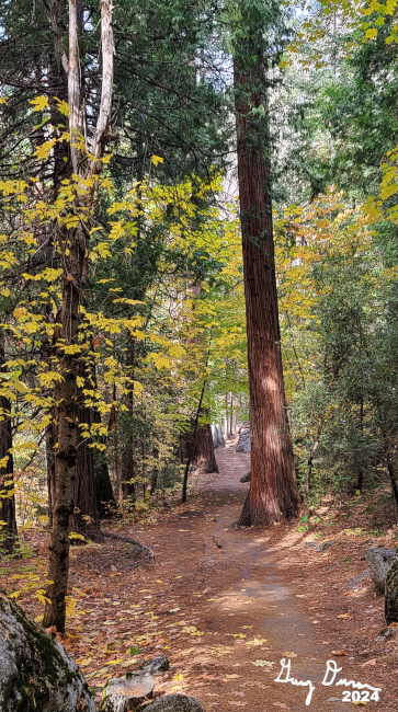
Sherri and I started hiking at about 11. We walked through Curry Village to the backpacker's parking lot. Then picked up a trail, away from the road. It is peaceful back here. With the trees changing colors, I am filled with the joy of Creation. Muir said something like this: Nature's peace will flow into you as sunshine flows into trees. The winds will blow their own freshness into you, and the storms their energy, while cares will drop off like autumn leaves. With the Trump victory yesterday, this experience or joy is a bit jarring. But joy wins out here-at least for awhile. I think happiness it is not. Happiness seems like it is an emotional response to something. While I think joy is something deeper. First, from a negative, I would not have responded to Trump’s victory with joy-maybe anger, depression or disbelief, but not joy. I am wondering if joy is the response to beauty? Or is this something even deeper than that? Maybe the closer we are to the Creator we can get a residual of this deep touch.

 Back to the trail. We go a little ways on it when we are joined by a hoard of school children. Not sure whom they are with. I was talking with someone and they said school age kids were being sponsored by the Sierra Club and another organization. They look like they are enjoying themselves and are well-behaved. And yet, it is a bit jarring seeing them along this rarely used trail. Still, I am glad I am seeing them there, soaking in the Valley and its wonders.


We get to
Happy Isles and only stop long enough to use the restroom-who know when the next one will be. After crossing the Happy Isles Bridge, we hop on the Valley Loop trail. The trail follows the road, but with only the trams and bicycles on it, we rarely hear it. But what we do start to see is an abundance of Fall colors. When we get to the Tenaya Bridge, we usually go up Tenaya Creek to the end of the trail. But we need to make use of an outhouse on the road to Mirror Lake. So we went up the road. I see an area which is completely enclosed by trees turning color. Mesmerizing.

Sherri on way to Mirror
After walking the road for a ways-to the outhouse--we turn and find the horse trail or Vslley LoopTrail up to Mirror Lake. It is a lot easier going the other way, down. Still we climb and enjoy the hike. It is a bit rocky. We meet only a few people going this way while the road has a number of people who are looking for the mirror-sort of like Taran in Lloyd Alexander’s Taran Wanderer
Ahwiyah Point
. The mirror will not be found today. But you will need to wait a paragraph or two to find this out. There are two young men who work for the concessions which we meet. They are appreciative of a few points which I can name.

By now it is 1:00 and we are ready for lunch. There is a nice area to eat which can be beside the water-no water today. Still there is enough of the Autumn environment to enjoy the surroundings. Normally when going to Mirror Lake, we would go up the canyon and loop back around Tenaya Creek. But calculating our rate of travel and the distance says this would not be a good idea. We would be coming in the dark. But as an alternative, Sherri suggests we walk on Mirror Lake. While the idea of walking on water appeals to me, it is not to be so. The Lake is dry with not even the creek running through it. We cross over to the the trail back to where we left it-we have done a loop.


Lunch Time
We decided to go along Tenaya Creek for a way. There is water in it! Where did it get the water after being dry at Mirror Lake? Something to investigate on another day. We follow the trail until it hits the Merced. Then go down the Merced. We visited the Upper Pines Campground and its bathrooms. We feel like hiking some more and end up at the Ahwahnee. There we treat ourselves to an ice cream sandwich-with it being so cold, why? But it felt so good, it was right. We also talked to a couple who had visited the park several times before and were looking for places to go. I do not think I added too much to the collective knowledge.


At this point, we decided that the two plus miles back to the car was not in the cards. So we hopped on the tram at the Ahwahnee. Evidently the tram has changed its routes. This one takes us all the way down to
El Capitan before coming back up the Southside Drive. Eventually we get back to Camp Curry and get let out there with a school group.That book ends our hike, I guess.

Where to Walk on Water-Mirror Lake in the Fall

The eternal question then is, where do we want to eat? We have been to El Cid the last two times and going to Southgate without Steven just does not seem right. So Sherri searches for a place and comes up with a place which is in where DiCicco;s used to be. Mountain Oaks Cafe is a place specializing in large quantity foods. I would say the food is good and hearty. I had a pastrami burger which was more than I wanted to eat. After dinner, it is home. But first we stop at REI to get a few things. Then it is home by 8:00pm. I am one tired puppy and am glad to take a shower.


Background

John Muir Quote: Our National Parks, 1901, page 56.


Extra Photo's


Washington Column and Tenaya Creek

Looking towards Yosemite Falls

North Dome from Mirror Lake

Half Dome From Mirror Lake

Tenaya Bridge

Valley Loop Trail

Autumn

Two rats face off

Sherri climbing steps

Autumn

Autumn on Tenaya Bridge

Autumn

Autumn

Autumn

Autumn

South Fork of the Merced


Animals


Flowers and Plants


Dogwood