Showing posts with label Camp 4. Show all posts

Wednesday, May 10, 2023

May 10, 2023 - Yosemite Valley-Dogwood Chasing


Title: May 10, 2023 - Yosemite Valley-Dogwood Chasing
 

Hike Info : DescriptionBackground : Extra Photo's : Flowers and Plants

Hike Info:

Type: Hiking

Trail head: Camp Curry

Trail: Glen Trail,  Merced River, Mirror Lake Road, Valley Loop

Destination:  None

Distance: 6.85 miles 1

Start Time:    11:00 

End Time:      6:24

Travel Time: 5:15  (1.31 mph)

Moving Time:  3:41  (1.86 mph)

Elevation Rise:  820'

Descent: 868‘


Maximum Elevation: 4,168' 

GPS Tracks in Two Parts; Camp Curry to Mirror Lake and Yosemite Falls 
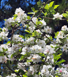
Dogwoods


Tram Riding:

Distance: 6.3 miles

Time: 0:37

 1The above information is computed from the actual hiking. There were times we jumped on a tram. Also Gary forgot the GPS and had to retrieve it. The distance, elevation and Travel and moving time on the Hike information is only for the walking time. The Start and End Time is for the entire journey.


Description:

Jessi is a lookout friend. Last year she asked about dogwoods in Yosemite. Evidently I did not lead her too far astray because she is interested in going up to Yosemite with us. Of course, Sherri and I are always looking for an excuse to visit Yosemite.


Jessi arrives a little after 8:30 and we are shortly on our way. Sherri starts off driving and I get a few minutes of rest. In Oakhurst, we change drivers. One of the good things about traveling with someone is that you find out a bit more about them. The lookout is good for meeting and enjoying people, but we really only see them twice a year. It is good just to have the time to talk. Oh yeah, Jessi is a delightful person.

Merced River
After stopping at Chinquapin, then Tunnel View. Tunnel View is in its full glory. Water is coming off the walls everywhere, not just the named falls. We do not spend much time there, but enough to appreciate possibilities for the day.

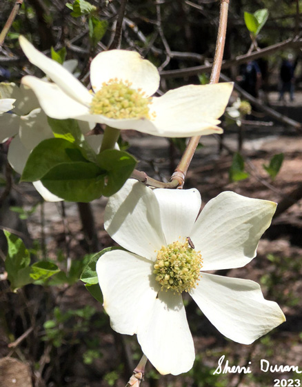
Dogwoods are what we are hunting for today. We are hoping that they are still vibrant and fresh. We get the first taste of them as we drive along Southside Drive. Looks like our hunting will be successful. We wheel into Camp Curry about 10:15. But we do not get boots onto the ground until after 10:30.

We walk up the road towards Happy Isles, Lots of dogwoods, which means that we stop every couple of yards and admire. Isn’t that why we came to Yosemite-well there are the falls and the walls and everything else.


Sherri and Jessi beside the Merced

When we get to the backpackers parking lot, we veer off to a trail which goes a bit south of the road, For being just a hundred yards away from the more traveled road, this trail is really quiet, I am concerned about this trail just because of all of the runoff and there is a section already swampy, I wonder how passable it is.

Suddenly an epiphany hits! I have left the GPS on top of the car. I told my companions to go ahead and I would meet them at Happy Isles. On the way back I wonder whom I can blame and the conclusion is that I only can blame myself. Sigh. Fortunately the GPS is still right where I left it.

I go up the road, rather than the trail,since it is slightly shorter and quicker. I probably went about 3/4 of a mile further than Sherri and Jessi. When I got there, there was no sign of them. But Sherri comes along and we meet up with Jessi. Lunch is the next topic. There is a little island-that stands to reason given the area’s name. We find a log and enjoy our lunch watching the Merced roar by.

Mirror Lake and Mt Watkins

We then start on our trek, crossing the Happy Isles Bridge. Here instead of following the Valley Loop Trail, we follow a trail which takes us along the Merced. This once paved trail is uneven with the constant water lapping against it season after season. Today it is dry and a joy to walk on. Like before we constantly stop and gawk. There is enough here for us to stay all afternoon.


Yosemite Falls
We are still energetic enough to climb the hill up to Mirror Lake. We see the other trail of the loop. Not for us today. Later on we find out that there are fallen trees across the trail and as I was suspecting, a bit wet. Jessi must be mesmerized by the trail because as slow as Sherri and I are, we can see her stopping often, finding the perfect way to shoot a flower, a tree or the walls of the Valley.

When we get to Mirror Lake, there is no reflection. But there is such a great view that I forgive it. Mt Watkins rises mid-canyon. Across from there is Ahwiyah Point. While not reflective, Tenaya Creek flowing through a full Mirror Lake makes the scene close to perfect.

Going to Yosemite Falls
When we leave the lake, Sherri and I get into a discussion with two couples. It can be a pleasure to exchange places with fellow backpackers about places where there is mutual connection. In this case, it was the Rae Lakes loop. Good to compare notes. I am afraid we have left Jessi to her own ways. But we find her waiting patiently a little ways further.


Horsetail Falls
We make a connection with a trail the horses use to get from the stables to Mirror Lake. I enjoy this section as few people actually walk it. Plus there are more flowers, more plants and, of course, dogwoods. Jessi asks if this will meet us at the road going up to Mirror Lake? I answer no, but am proven wrong. I usually continue on the Valley Loop to the Ahwahnee

 Today we head down the road to the Mirror Lake tram stop. Here, we pick up the Green bus which does the entire Valley. But we will get off at Yosemite Falls. It does hit the Ahwahnee. There the bus thins out and we can grab a seat. Who walks in? Several friends. Betty is the first one whom we recognize with her husband Randy. Theme there is John and Cathey, Rebecca and Keith, and a few others. It is always a good thing to meet friends unexpectedly.


Bridalveil Falls from Valley View


They get off before we do. Jessi, Sherri and I continue on to Yosemite Falls. It is running full, but with little wind. So the spray makes it down to the bridge over Yosemite Creek in small amounts. We hardly feel it. Our return trip gets us back to Yosemite Village. There we hunt out the suitable bus stop, number 2 if you really want to know. And then it is a long wait. Long enough that we all sit down on the ground to wait. After about 25 minutes, the Purple tram line comes and takes us back to Curry Village.

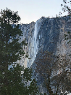
By this time, it is almost 6:30 and time to head home. But first, we stop at a turn out after Camp 4. Horsetail Falls is running nicely, but it is a bit late in the day, so the sun does not show off its splendor. But the Valley has one last parting gift for us. At the west end of the Valley is a popular turn out called Valley View. Today it shows us why it is so popular. With the deepening evening shadows, the sun draws lines of dark and light across the walls with Bridalveil just glistening there.

Fern Springs

Actually there was one more parting gift. We stopped by Fern Spring-Jessi, I had the wrong name. Black Spring is across the Valley from Fern Spring. Fern Spring is a quiet little pool of water which most people pass by. Today it is gushing. And now this is the way to leave the valley.

We get to Oakhurst about 8 and all of us are ready to eat. So we stop in at El Cids-the first time Sherri and I have been here in three or four years, The burritos hit the spot. In appreciation for the day, Jessi pays for our meals-she probably overpaid the tour guide in this regard as we enjoy Yosemite and would enjoy going up even without her. But with her, it just made it that much better. We get back to Fresno about 9:30. Poor Jessi has a bit more of a drive. I am tired but have enjoyed the day.


Background


Extra Photo's

Jessi and Gary on the trail

Merced River

Indian Canyon Falls

Stair Step Falls

Silver Strand Falls

Yosemite Valley from Tunnel View

Flower Child Gary
Yosemite Falls

El Capitan, Bridalveil Falls and the Merced from Valley View

Fern Spring

Fern Springs

Coyote seeking attention


Flowers and Plants


Dogwoods


Unknown


Wednesday, May 5, 2021

May 5, 2021 - Middle Yosemite Valley


May 5, 2021 - Middle Yosemite Valley
Hike Info : DescriptionExtra Photo's : Animals : Flowers and Plants
 
Hike Info:
Type: Hiking
Trail:  Valley Loop
Destination:
Actual Destination:
Distance: 8.53 miles 1
Start Time: 9:51
End Time:  3:59
Travel Time: 6:07  (1.39 mph)
Moving Time:  4:34  (1.87 mph)
Elevation Rise: 568 '
Descent: 585‘
Maximum Elevation: 4,060'  

GPS Tracks

  1There was a wide range of mileage readings. This particular one is from our Garmin 60CSX. My Garmin Foretrex401 9.94. While Rose’s InReach was above 10 miles. The 8.53 is more in line with the expected mileage. The Valley walls can sometimes play havoc with GPS signals.

Description:

Rose and Sherri examining a climber's van


It has been a couple of weeks since we have hiked with The Sisterhood. First Betty had a commitment. Then Carol had a hard week at work. So she begged out. So Rose is stuck with Sherri and I.

It has a potential of being a long day, so we get off to an earlier start than usual. We had planned on leaving Fresno at 7:15, but got off a few minutes late. We will meet Rose at Chinquapin. But first, we need to get through a couple of construction sites, but we get to Chinquapin only five to ten minutes after Rose. We continue onto the Valley. I had suggested that we park at the lower end of the Valley so we walk downhill on the way back.

El  Capitan and the Perced
We found a place to park right before the El Capitan Road on the south side of the Valley. We will go clockwise on the theory that with it being predicted to be warm today, we should be a bit more in the shadows in the afternoon.

We get ready to go just before 10. We head north along El Capitan Road. Just before the bridge, we see a climber’s van. How do we know that it belongs to a climber? There are routes drawn on the side of the van up El Capitan. We stop and look with interest.

Dead Tree Disguised as a Rope

But as much as we want to wonder about the owner, we have miles to go. Off we go. We turn east along the north side of the Merced. We move pretty good. After a short way, we met a couple. We talk and wonder if there are climbers on El Capitan. It does not look like it. I think I see a rope hanging from an overhang-Rose points out that it is a dead tree. Imagine a dead tree disguising itself as rope.

A short distance later, we hit the Valley Loop Trail and continue east. The trail follows the road, but then it leaves the road, following the river. But there is a need for some personal necessity. The El Capitan Picnic Area is a short ways ahead, so we continue to follow the road.

Gary meets a friend
 

The picnic area was a bit further away than imagined in my mind. The principal attraction of the picnic area is the outhouse, but not the only attraction. As we leave we see a lone redbud, but looking pretty nice. Looking around, there is El Capitan and Sentinel Falls, and of course, all of Yosemite Valley.

Sentinel Falls
We find a path back to the Valley Loop and continue on. The path is still pretty level. We come to a parking area and see a few more people. A bit beyond is a tree which has split--I call it the Tree of Doom. We need to walk right under it. I approach a bit apprehensive and proceed to scurry below it. Rose and Sherri come after me with none of that apprehension. A short way further we cross the Northside Road.

Now we pass by the site of the old Indian village. There is construction going on. But there is also a sign talking about an event taking place. We go past the SAR village and into a deserted Camp 4. We decide this is a better place to have lunch rather than going on to the

Tree of Doom-Rose and Sherri walkign
Yosemite Falls picnic area. Lunch is our normal stuff. But the bathrooms are not open, so we continue on.

It is a short walk to the Falls. They are beautiful like always. Maybe not as full as it should be in mid-Spring, still a thing of beauty. Also it is not too crowded, at least by Yosemite standards. Even with the decreased amount of water coming down, there is a nice wind being generated. Evidently it is enough of a breeze that if a person is not attentive, they may lose her hat. I do grab mine, but Sherri is not as quick. Her hat goes over the bridge onto the rocks before-at least not into the creek. Then yours truly, your faithful narrator, a chance to play super-hero. So he does an old man type of waddle around and down and picks up the hat. He gets a hero welcome.

Lower Yosemite Falls

The Dogwood patrol


We continued on going the long way back to the Falls bathrooms.Maybe I should say this was the scenic route. Usually not as many people, but today there is a fair number of people. There is a slight mix up at the bathroom-we were looking for each other and not finding us. Eventually we hook up and are off.


Gary Rescuing a hat


There is a decision that we should do the shorter route back to the car. So we cut through the Yosemite Lodge area. Even here we are blessed. I think we come across the epitome of what a dogwood should look like-unfortunately our pictures are not of the same quality as this tree. It seems like everywhere we look there is a dogwood gracing our vision.

And there is a fireplug. And what is one of those things good for?


Wow! Such a nice shaped dogwood
The next point of interest is the Swinging Bridge. Here we meet a guy who wants to know about some of the floods as well as landmarks in the Valley, also where is it-we are standing on it. But this is not the original which got wiped out during floods. I spend some time giving my impression of a tour interpreter. Seems to impress the guy enough. But I do think this bridge and a bit of the area gives one of the better views of the Valley. Half Dome and Clouds Rest, not to mention North Dome, Washington Column, and Glacier Point are all in view. Looking the other way, El Cap and Cathedral Rocks all dominate view to the west. What a place! I like to think that God created this place to perfection. It is up to us not to spoil it.


Fireplug


View From Swinging Bridge
 

Sherri and Rose spot a set of falls to the side of Indian Canyon. I do not know what creek that it-I do not think it is Indian Creek as that runs down the canyon. Later when I get home and look at a topo map, I figure out that it is Lehamite Creek which has a pretty good size falls, even if it is ephemeral.

The south side of the Valley Loop Trail greets us. We know that we are on the home stretch-even though we know we have a ways to go. I am beginning to feel my legs want an end soon. I do not hike as well in warm temperatures and it is over 800 today. My theory about walking on the south side is not true, at least during the Spring, and probably the Fall. Still there are miles left in them.

Crossing Sentinel Creek


We come to the Four Mile Trail, and pass by it. Then it is up and down some small ridges-this does not do much for my legs. And then I hear what looks like a chainsaw. What is one doing in the Valley? A few minutes later, we spot a fire crew working on bringing down some of the dead trees. We briefly talked with the leader and he said it was OK to go through-the guys (and gal) will pause when we are near. 


Valley Loop on the Southside


A ways later we come across a couple who we talked with earlier (I do not recognize them, but they do us.) They have also picked up a person as well. We tell them about the crew ahead. They seem to have enjoyed the trail as much as us-always a good thing.

And now we come to the trail junction which leads us back to the El Capitan Road. And then a short walk back to the car! Glad to get back. After getting our hiking stuff stowed, The three of us talk-seems like we do not want to part. After 45 minutes we do seperate, going our own ways. We stop in Oakhurst for a bite to eat before heading home. Another good day.


Extra Photo's
Yosemite Falls

Where are the people?

El Capitan

El Capitan

Gary with Rose and Sherri looking at Manzanita

Yosemite Falls

Sentinel Falls

Looking east up the Merced

Flowers on a rock

Yosemite Falls-Rose and Gary

Middle Yosemite Falls

Dogwood

Dogwood and Sentinel Point

Lower Yosemite Falls

Dogwood and Yosemite Falls

Gary and the Falls


Sherri and Rose admiring the view

Rose crossing Sentinel Creek

Gary and the Gunsight

El Capitan

Yosemite Falls

Animals

Mallard


Flowers and Plants

Manzanita


Dogwood


Redbud