Showing posts with label Grizzly. Show all posts

Saturday, July 13, 2024

July 13, 2024 - Park Ridge Lookout


Title: July 13, 2024 - Park Ridge Lookout
Hike Info : DescriptionBackgroundExtra Photo's 
Hike Info:

Type: Lookout

Description:

CalFire Warning

I got up at 0530 and did my lightning report. There were some cloud-to-cloud, but none hit the ground. So the report was rather simple. I was done by 0615. Then I started working on getting the car loaded. Not much excitement here. We had decided to go out to the Train Depot for breakfast. We get there by 0850, with a few minute wait. I had a Frankie’s Omelete. Filling and good tasting It was just before 1000 before we got back, in time for Steven’s game time with his friends.

Sherri and I get the finishing touches on what we are going to take up to Park Ridge Lookout. In the meantime, I get an email asking that a couple of people want to be added to receive my lightning report. Interesting that this little niche report which I thought a few people might be interested in has become a useful tool. Anyway, Wendy and I also talked about the concerns of the day. That is lightning. Fire Weather has today with an LAL of 2, then going to 6 this afternoon. See Background below for more.

Park Ridge Lookout
By 1130 we are on our way. But first, we stopped at a furniture store. Sherri orders some sofa pillows there. By the time we leave it is 1230. Sherri drives up to Big Stump and we talk about what today might be like. It is said that normal people run away from danger while firefighters and the police run towards it. I am thinking this is more of an exercise of walking towards danger-we know there are safeguards in the lookout so, we are not too concerned as long as we take care to do our part.


I drive up to
Panoramic Point and then to Park Ridge. There is a spring which turns a small section of the dirt road into a quagmire. But we make it through without trouble. We get to the lookout at 1430. I think Peggy, the lookout which we are relieving, is glad to get out of the tower before the lightning starts. She lets us know what the status is. Seems like it has been a good morning for her. I asked her about a person I had read about in a book, Cool, Gray City of Love. Turns out she will be having lunch with her soon.

After Peggy leaves, I start bringing up stuff and then the wind starts to blow hard and the rain starts in. I am thinking it feels like it will rain hard, but it just sprinkles enough to turn the dust on the car to mud, but not enough to wash it away.
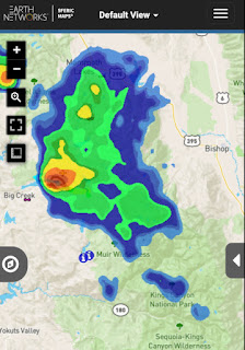
Cells in the Sierra

I hear on the radio that Division 3 and Buck Rock Lookout are talking about the status of Buck Rock. Buck Rock is saying that he is not seeing lightning. But as he says that I lookout and note a strike to the east, a little north of where Buck Rock is located. But I am not sure where the strike is as there are hills and ridges blocking my view. I relay this information to them.

There is activity down south, enough so that Peggy has said the Hume Lake area is using a different command channel than they are usually using. Turns out they got hit hard with lighting which has started several fires. One of them, the Trout, keeps getting mentioned.

On our end of the world, Buck Rock notes there is a cell going up Ten Mile Canyon. But there is no lightning seen. That turns out to be the most excitement weatherwise we have. It generates some wind and rain, but the rain is away from us. Buck Rock and us do discuss the weather and what it looks like on each other's areas.

Then we get into hearing about oddities. Not from Buck Rock, but from Porterville. A smoldering stump has been reported at Jennie Lake. Not one hit by lightning, but somebody had built a campfire into the stump and did not put it out. Maybe they did not realize how hard that would be. It is late in the afternoon, so DIvision 3 says they will send someone up there tomorrow. And then we are back to the normal interesting things like a tree falling across the road into Cedar Grove around Grizzly Falls.


Normally, we would go out of service at 1800, but we will be on extended hours today and tomorrow. Buck Rock has a drive home, so they are leaving at 1800 after checking in with Division 3.
Delilah is going out of service with Sierra, but somehow it gets communicated on Porterville’s channel. I talk with Delilah and they have it straightened out. They also had a shift change about that time and I will be talking with Delilah for the rest of my time at Park Ridge.

The reason why we have extended hours is because of serious conditions. In this case it is the lightning. I usually get to experience it during holiday weekends. After 1800, the shadows make it hard to see too much, but we look, concentrating on where visibility allows us to see. We also have our lasagna dinner-sorry, no pictures. In 2000, we went out of service.

Sherri and I get ready for bed. The light is starting to fade. But we have enough time to go for a short walk down the road, maybe about 100 yards and then turn around. The sunset is good. Between Park Ridge and Delilah, I think Park Ridge has a little bit better sunsets. It may be because Park Ridge has a nice wide catwalk facing west. After getting our reward for being up here, we settle down to our bedtime routine about 2145. I am out by 2215.


Background

LAL. Lightning Activity Level: The idea behind this item is to alert people to the potential for lightning and what type it is. There are six levels, but levels are not like hurricane levels where it designates the strength of the activity. Rather it talks about the likelihood of activity and the types. Such as a 2 says there may be isolated thunderstorms and a 3 says widely scattered thunderstorms. But a 6 says that like 3 there will be widely scattered thunderstorms, but it is likely to be dry rather than having rain associated with it.

 
 Extra Photo's

Moon through Park Ridge's stairs

Magical evening time

Last light of day

Tuesday, September 6, 2022

September 6, 2022 - Delilah


Title: September 6, 2022 - Delilah
Hike Info : Description : Background  Animals 
Hike Info:
Type:Lookout

Description:

My last day on this stint at Delilah, and what is predicted to be the hottest. I am not sure what it is, maybe heat. maybe old age-i hope it is heat, not old age-but I feel like I want to go home. I guess I am tired. These are long days. I am looking forward to getting off at 1800

I get up at 0520 and start my lightning report. There were six strikes all west of Florence Lake, but several cloud to cloud east of Buck Rock. She heard them last night.

Watts and Burroughs Valley-where the fire was yesterday
I go into service at 0700-for once on time at Delilah, I go in-service when the Forest thought I was going in. I finish up the lightning report on Forest time at 0720. After doing a few scans, I have my breakfast. By 0900, it is 90 degrees inside of the cab and by 1000 it is 91 outside and 94 inside. When I take the weather, the RH is 20%. This catches the Forest’s attention. I now go into my wet T-Shirt and cap mode. Any bets on if and when the cab will reach 100 degrees?


By the way, in an earlier blog, I talked about the birds at Delilah. Add sparrows in as well. Usually there are turkey vultures, but so far I have not seen them. Also several times dragonflies have entered into my binoculars field of vision. Talking about objects being closer than they appear. The first time, I wonder what is going to devour me.


Along the lines of birds, I made hummingbird water for the first time. Sherri usually does that. Now to see if the hummingbirds like my attempt.

It must be a rule of mine: there must be at least one fax paus each day I am in a tower. Today’s attempt at mucking up is that I missed the 1100 Sierra lookout check-in. Why you might ask? I am usually pretty regular with that one. While my hand-held radio battery decided it had lost all of its energy. I cannot blame it as with this heat, I have lost a lot of energy myself. Thanks to Buck Rock, I found out that I had been missed. So I called in that I was all safe and sound.


Clouds and the Kings River
 

Otherwise, life continues on. I scan and practice placing locations in my range. I have in my notes for the next person: be careful of the railings. They get scorching hot. Also I listen in on conversations. Such as the Forest is getting ready to release water from Hume Lake to do repairs. There is a lot of coordination. First between the contractors and the Forest. Then getting the personnel at Hume Lake to make sure everybody is safe in the Lake and down stream. Then finally to open the valve. Also the Forest personnel try to take care of the visitors. Such as a lady had a flat tire down by Grizzly Falls. Patrol 33 was sent down to assess and try to help. Patrol 33 ended up taking the lady into Cedar Grove to phone for assistance.

Just before 1500, I heard of a smoke being spotted at Redinger Lake. It is outside of where I can see, but I look anyway in case I can see it. Nope-too big of a ridge between Delilah and the San Joaquin River.


Water Gate opened at Hume Lake

Porterville notes that Forest personnel are on from 0730 to 1930 this week. I talk with Buck Rock and she is in agreement that I can still go out of service at 1800. I am thankful for that. The only other thing which happens is Richard calls up. He is coming in tomorrow and wants to know about anything he should be concerned about. Not really. There was a fire, but it was cleared up. But I tell him, be prepared for it to be hot. I then clean up the cab-disinfecting the counter tops, mopping the floor, getting rid of the trash. At 1813 I go out of service with both Sierra and Porterville.

The drive home is uneventful. I got home a few minutes after 2000, tired but feeling good. Particularly after taking a shower and having some ice cream.

I would be remiss in leaving without calling out people who called to check in, or have conversation with me. These people include Kathy, Wendy, Doug, and, of course, Sherri-my wife. Thank you!


Background

Time

Outdoor Temp

Indoor Temp

0600

82

83

0900

87

90

1000

91

94

1100

93

95

1200

91

93

1300

92

93

1400

93

93

1600

93

95


Animals


Monday, July 26, 2021

: July 26, 2021 - Cedar Grove


Title: : July 26, 2021 - Cedar Grove
Hike Info : DescriptionMenu : Extra Photo's : Flowers and Plants


Trail head:  Gate on Road 13S07
Hike Info:
Type: Hiking : Car
Trail: Road 13S07
Destination: Indian Basin Grove
Actual Destination: Junction with Road 13S50
Distance:  2.25 miles
Start Time:3:02
End Time: 4:46
Travel Time:  1:44 (1.30 mph)
Moving Time:  1:19  (1.71 mph)
Elevation Rise:  317'
Descent:  344'
Maximum Elevation: 6,253'
GPS Tracks

Description:

Neither one of us are feeling too energetic. Must be a sign that we have not gotten out enough if a drive up here and preparation has us depleted.So we have decided to take a car trip down to Cedar Grove and just do some short stuff around there.

Grizzly Falls

But first, we must get up. I got up at 6;00 and walked to the Grant Grove Visitor Center for their WiFi. No lightning was picked up, but I did load my email. I get back to camp at 7:30. Sherri gets up a little before 8:00. We have french toast for breakfast. It is a slow morning. We read until 11:00.


We get into the car and take off to Kings Canyon, Our first stop is
Grizzly Falls. This is a falls right off the road which until looking at Anne Marie Brown’s book, California Waterfalls I did not know about.We find a parking place right in front. When we stop out of the car, the heat hits us-the upper 80’s. The waterfall is only 50 yards off the road. I am expecting only a trickle, but there is enough water to make it a worthwhile walk.


Gary and Sherri at Roaring River Falls
 We head into the Canyon proper. We stop at the Cedar Grove Visitor Center to see if they have WiFi-no-so we do not even step out of the car. It is warm. Then we get to Roaring River Falls. It is a bit down from the last time we saw it. But I do not think I have ever seen it not worth the 200 yard walk. The firefighters from Engine 337 walk by us before we realize who they are. We have lunch and then I take a 20 minute nap.

Onward to Zumwalt Meadows where we intend to take a walk around the meadow-about 2 miles or so. But the parking area is full so we continue on to Road’s End. The lots there are pretty full, except for the ones at the very end. It is 92o. So we decide we are not really interested in trudging through the hot sand to the Bailey Bridge and back.


Middle Fork of Kings from Vista Point


 We turn around and drive out of the Canyon. It is Sherri’s turn to take a nap. We had said we wanted to take a look at the Princess Campground. Looks like it is well taken care of-some friends of ours like to camp here. With our Senior discount, Sunset is a bit cheaper and closer to many of the places we like to go to.


Across Highway 180 is Forest Service Road 13S07. Ordinarily, I am only moderately interested in Forest Service roads like these-they are more to get to someplace than a scenic drive. They usually are a bit rough for an enjoyable drive. But I had spotted that there was a Sequoia Grove, Indian Basin Grove, up this road. After we go up it a ways, there is a gate closing further travel via car.


We are up higher than the Canyon and the temperature has cooled a bit. We are both interested in a short walk, so off we go. It is a moderate rise up. It feels good to be out stretching our legs. We see a few signs of tree bases having been scorched. But I wonder what fire? (From CalTopo, it looks like the Rough Fire). Will need to look it up when we get back home. After half of a mile we see what looks like a young Sequoia-by young let's say 150 years old (only a guess on my part). Even young there is a burgeoning majesty to them. We think we see a trail, more like an old road which we follow for a ways. There is a sign saying Giant Sequoia Grove Boundary. Evidently we are on the right track. Our old road is getting more overgrown and starting to head down into a ravine, so we just look around, then return to 13S07.


We continue heading up the road, not intending to go very far. But we do find a couple of places where we can look down into the Grove. Fun trying to pick out what are Sequoias and what ones are cedars. The road climbs up gradually, or flattens out. We hear the sound of thunder rippling across the sky. Will there be more? (Turns out when I checked the lightning report the next day, there was no lightning in this area. Did we hear the sound of a tree falling? If so, it was a large tree.)

We come to the junction with road 13S50. Here we look around, catching glimpses of the mountains across the Kings River. We walk back down the road to the car. No more excitement. We stopped at Grant Grove Visitor Center, but were not able to pick up an Internet connection there.

When we get back to camp, Sherri fixes us a chicken-cheese sandwich for dinner. But we run into a problem-no more propane! I thought I had brought a nearly full one-guess not. So we have a cold sandwich.


Greg had left a text about a problem getting to a web site and do I have any thoughts about what it could be? Yes I do, so I called him back. We talked about the problem. Then I ask him if the stores in the area sell propane canisters? He does not know, but he has a couple new ones which we can have. We make arrangements to meet at the Delilah turn off tomorrow. Yippee! This is so good.


Road 13S07

Sherri and I play Cribbage some more. Then it starts to sprinkle, so we throw things into the tent. When we get into the tent, discover that several of the Cribbage pegs have broken. That ends the game, that and the solar light keeps going out on us. Time to read and go to sleep


Menu

Breakfast

Lunch

Dinner

Snacks

French Toast, Syrup, and butter.

Peanut Butter, Nutella sandwich and chips


Chicken-cheese sandwich, cold


Clif Bar, GORP, Jelly Belly


Extra Photo's

Road 13S07


Ridge off of Converse Mountain

Mountain Misery looking better than it actually is

Gary wondering, "Are we lost yet?"


Looking down into Indian Basin Grove

Ridge off of Deer Spur with Spanish Mountain in background

Edge of North Dome

Roaring River Falls

Grizzly Falls

 
Flowers and Plants

Aster of some type, I think

Wednesday, January 7, 1970

Places: CA-Grizzly Falls

 
Grizzly Falls-4,692' (Cedar Grove) (36.8049428, -118.7459348)

Location is really the picnic area
Legal: T__S, R__E, Sec__


DegMinVertical DegMinutesDistance
Delilah


Park Ridge


Buck Rock


East Fork Grizzly Creek-6,227' (Cedar Grove) (36.8254977, -118.7287126)
Legal: T__S, R__E, Sec__


DegMinVertical DegMinutesDistance
Delilah


Park Ridge


Buck Rock


Grizzly Lake-9,659' (Cedar Grove) (36.8643343, -118.7213287)
Legal: T__S, R__E, Sec__


DegMinVertical DegMinutesDistance
Delilah


Park Ridge


Buck Rock


Grizzly Creek-4,219' (Cedar Grove) (36.8024428, -118.7448236)
Legal: T__S, R__E, Sec__


DegMinVertical DegMinutesDistance
Delilah


Park Ridge


Buck Rock


Description : Trips : References : Pictures 


Description:

On GNIS:

  • East Fork Grizzly Creek. Also known as East Fork Grizzley Creek


Trips:


References:

Pictures: