Showing posts with label Mt. Watkins. Show all posts

Wednesday, May 10, 2023

May 10, 2023 - Yosemite Valley-Dogwood Chasing


Title: May 10, 2023 - Yosemite Valley-Dogwood Chasing
 

Hike Info : Description :  Background : Extra Photo's : Flowers and Plants

Hike Info:

Type: Hiking

Trail head: Camp Curry

Trail: Glen Trail,  Merced River, Mirror Lake Road, Valley Loop

Destination:  None

Distance: 6.85 miles 1

Start Time:    11:00 

End Time:      6:24

Travel Time: 5:15  (1.31 mph)

Moving Time:  3:41  (1.86 mph)

Elevation Rise:  820'

Descent: 868‘


Maximum Elevation: 4,168' 

GPS Tracks in Two Parts; Camp Curry to Mirror Lake and Yosemite Falls 

Dogwoods


Tram Riding:

Distance: 6.3 miles

Time: 0:37

 1The above information is computed from the actual hiking. There were times we jumped on a tram. Also Gary forgot the GPS and had to retrieve it. The distance, elevation and Travel and moving time on the Hike information is only for the walking time. The Start and End Time is for the entire journey.


Description:

Jessi is a lookout friend. Last year she asked about dogwoods in Yosemite. Evidently I did not lead her too far astray because she is interested in going up to Yosemite with us. Of course, Sherri and I are always looking for an excuse to visit Yosemite.


Jessi arrives a little after 8:30 and we are shortly on our way. Sherri starts off driving and I get a few minutes of rest. In Oakhurst, we change drivers. One of the good things about traveling with someone is that you find out a bit more about them. The lookout is good for meeting and enjoying people, but we really only see them twice a year. It is good just to have the time to talk. Oh yeah, Jessi is a delightful person.

Merced River
After stopping at Chinquapin, then Tunnel View. Tunnel View is in its full glory. Water is coming off the walls everywhere, not just the named falls. We do not spend much time there, but enough to appreciate possibilities for the day.

Dogwoods are what we are hunting for today. We are hoping that they are still vibrant and fresh. We get the first taste of them as we drive along Southside Drive. Looks like our hunting will be successful. We wheel into Camp Curry about 10:15. But we do not get boots onto the ground until after 10:30.

We walk up the road towards Happy Isles, Lots of dogwoods, which means that we stop every couple of yards and admire. Isn’t that why we came to Yosemite-well there are the falls and the walls and everything else.


Sherri and Jessi beside the Merced

When we get to the backpackers parking lot, we veer off to a trail which goes a bit south of the road, For being just a hundred yards away from the more traveled road, this trail is really quiet, I am concerned about this trail just because of all of the runoff and there is a section already swampy, I wonder how passable it is.

Suddenly an epiphany hits! I have left the GPS on top of the car. I told my companions to go ahead and I would meet them at Happy Isles. On the way back I wonder whom I can blame and the conclusion is that I only can blame myself. Sigh. Fortunately the GPS is still right where I left it.

I go up the road, rather than the trail,since it is slightly shorter and quicker. I probably went about 3/4 of a mile further than Sherri and Jessi. When I got there, there was no sign of them. But Sherri comes along and we meet up with Jessi. Lunch is the next topic. There is a little island-that stands to reason given the area’s name. We find a log and enjoy our lunch watching the Merced roar by.

Mirror Lake and Mt Watkins

We then start on our trek, crossing the Happy Isles Bridge. Here instead of following the Valley Loop Trail, we follow a trail which takes us along the Merced. This once paved trail is uneven with the constant water lapping against it season after season. Today it is dry and a joy to walk on. Like before we constantly stop and gawk. There is enough here for us to stay all afternoon.


Yosemite Falls
We are still energetic enough to climb the hill up to Mirror Lake. We see the other trail of the loop. Not for us today. Later on we find out that there are fallen trees across the trail and as I was suspecting, a bit wet. Jessi must be mesmerized by the trail because as slow as Sherri and I are, we can see her stopping often, finding the perfect way to shoot a flower, a tree or the walls of the Valley.

When we get to Mirror Lake, there is no reflection. But there is such a great view that I forgive it. Mt Watkins rises mid-canyon. Across from there is Ahwiyah Point. While not reflective, Tenaya Creek flowing through a full Mirror Lake makes the scene close to perfect.

Going to Yosemite Falls
When we leave the lake, Sherri and I get into a discussion with two couples. It can be a pleasure to exchange places with fellow backpackers about places where there is mutual connection. In this case, it was the Rae Lakes loop. Good to compare notes. I am afraid we have left Jessi to her own ways. But we find her waiting patiently a little ways further.


Horsetail Falls
We make a connection with a trail the horses use to get from the stables to Mirror Lake. I enjoy this section as few people actually walk it. Plus there are more flowers, more plants and, of course, dogwoods. Jessi asks if this will meet us at the road going up to Mirror Lake? I answer no, but am proven wrong. I usually continue on the Valley Loop to the Ahwahnee. 

 Today we head down the road to the Mirror Lake tram stop. Here, we pick up the Green bus which does the entire Valley. But we will get off at Yosemite Falls. It does hit the Ahwahnee. There the bus thins out and we can grab a seat. Who walks in? Several friends. Betty is the first one whom we recognize with her husband Randy. Theme there is John and Cathey, Rebecca and Keith, and a few others. It is always a good thing to meet friends unexpectedly.


Bridalveil Falls from Valley View


They get off before we do. Jessi, Sherri and I continue on to Yosemite Falls. It is running full, but with little wind. So the spray makes it down to the bridge over Yosemite Creek in small amounts. We hardly feel it. Our return trip gets us back to Yosemite Village. There we hunt out the suitable bus stop, number 2 if you really want to know. And then it is a long wait. Long enough that we all sit down on the ground to wait. After about 25 minutes, the Purple tram line comes and takes us back to Curry Village.

By this time, it is almost 6:30 and time to head home. But first, we stop at a turn out after Camp 4. Horsetail Falls is running nicely, but it is a bit late in the day, so the sun does not show off its splendor. But the Valley has one last parting gift for us. At the west end of the Valley is a popular turn out called Valley View. Today it shows us why it is so popular. With the deepening evening shadows, the sun draws lines of dark and light across the walls with Bridalveil just glistening there.

Fern Springs

Actually there was one more parting gift. We stopped by Fern Spring-Jessi, I had the wrong name. Black Spring is across the Valley from Fern Spring. Fern Spring is a quiet little pool of water which most people pass by. Today it is gushing. And now this is the way to leave the valley.

We get to Oakhurst about 8 and all of us are ready to eat. So we stop in at El Cids-the first time Sherri and I have been here in three or four years, The burritos hit the spot. In appreciation for the day, Jessi pays for our meals-she probably overpaid the tour guide in this regard as we enjoy Yosemite and would enjoy going up even without her. But with her, it just made it that much better. We get back to Fresno about 9:30. Poor Jessi has a bit more of a drive. I am tired but have enjoyed the day.


Background


Extra Photo's

Jessi and Gary on the trail

Merced River

Indian Canyon Falls

Stair Step Falls

Silver Strand Falls

Yosemite Valley from Tunnel View

Flower Child Gary
Yosemite Falls

El Capitan, Bridalveil Falls and the Merced from Valley View

Fern Spring

Fern Springs

Coyote seeking attention


Flowers and Plants


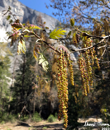
Dogwoods


Unknown


Saturday, March 10, 2018

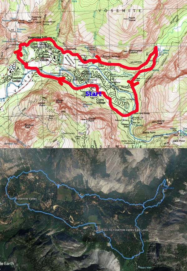
March 10, 2018 - Yosemite Valley East Loop


Title: March 10, 2018 - Yosemite Valley East Loop
Hike Info : Description : Trail Lessons : Background : Extra Photo's 
Hike Info:
Type: Hiking
Trail: Valley Loop Trail
Destination: Loop
Distance:  8.74 miles
Start Time: 9:37
End Time:  3:01
Travel Time:   5:24 (1.62 mph)
Moving Time:  3:41 (2.37 mph)
Elevation Rise:  958'1 
Descent: 871‘
Maximum Elevation: 4,241'

 
1I have some doubts about these figures. On a FitBit, one person recorded 650’
 of climb, another recorded 550’ on a SmartPhone tracking device.

Yosemite Falls from Stoneman Meadow
Description:
This is a Meetup hike, but with the idea which Sherri and I are getting ready to walk the half marathon at the California Classic. The idea is that each week leading up to the half marathon on April 8th, we will go on longer and faster hikes. So the schedule is to do the loop around the eastern Yosemite Valley.
But, the week before, the weather forecast ranged from rain to snow to sun and back to rain. So there is some concern about the weather for the hike. On the morning the of the hike? The forecast is for a good amount of rain with a light rain starting at 11am.
Sherri, Oz and Half Dome
We gather at 6:45 five of us, waiting for a person who never shows. We briefly stop in Oakhurst for coffee and then hurry on, hoping to beat the rain. There is another brief bathroom stop at Bridalveil Falls. Going along the south side of the Valley, we see snow, lots of snow. This affects my thinking of how to do the hike-rethink about going around Mirror Lake and going clockwise around the loop instead of the traditional counter-clockwise.


Oz and Half Dome At Sentinel Bridge


We get to Camp Curry at 9:30 and start walking soon afterwards. We quickly get the benefits of going clockwise as we get good views of Half Dome and Yosemite Falls-Stoneman Meadow has such good views. Then we pass by the employee housing, The first mile or so is paved for bicycles. When we get to Sentinel Bridge, we cut over towards Yosemite Falls. But not before stopping at this huge granite boulder. What is so special about the boulder? There are a couple of iron rings planted in here. The question is, why? But we also talk a bit about the old village which used to be around here.


Map of Old Yosemite Village from  Eldon Grupp

Yosemite Falls


Then it is time to cross Cook’s Meadow on the way to Yosemite Falls. Of course, I cannot help but to talk a bit about the hotel which used to be here. A sign already lets the group know about the use of the meadow. Then onwards to the Falls, with a brief stop at the bathrooms. When we do go over Yosemite Creek Bridge, it is time for another talk explaining that there are eight (now seven) historic bridges in Yosemite Valley on the National Historic Landmark Registry.
Gary, the Tour Guide
Lost Arrow
Yosemite Falls does not disappoint us. Sometimes the falls are running so strong, you cannot walk across the bridge because of the spray; other times you think that NPS may have forgotten to pay their water bill. But today, the Falls have enough water to go over and create some pretty good eye candy. There is an ice cone at the bottom of the upper falls, but none at the lower. From the viewing area, we can also see Lost Arrow. Here I go into an abbreviated, unpoetic version of the story of Lost Arrow. After looking for a few minutes, we continue on the northern part of the Valley Loop Trail.

This part of the loop goes about a hundred feet above the current Yosemite Visitor Center and along the northern wall. We meet a couple from Visalia along this section, exchanging greetings. While in most places, there are too many trees for a good view-strange complaint isn’t it-we do get glimpses of the Valley floor. Still it is enjoyable, even though I huff and puff a bit. After the stretch, we come down the trail into the Ahwahnee Meadow area. There is all the luxury you would want on a hike and for lunch: picnic tables and flush toilets. You got to admit, Life is Good!
After we finish lunch-mine the traditional sandwich of the Duran’s, we continue on. Nobody was interested in going into the Ahwahnee Hotel, so we continue on towards Mirror Lake. The tricklets we see on the Royal Arches combines up into a nice little creek which we are thankful for stones placed strategically along the trail for a dry crossing. Earlier I had talked about Indian Canyon and the escape routes which the Native Americans had to escape the Army. The other place is the Indian Caves close to the foot of Washington Column.
Mirror Lake Ice

Mt Watkins and Ahwiyah Pt

Ahwiyah Pt and Half Dome


After that, it is, easy walking until we reach the bathroom at the foot of the Mirror Lake grade. We stop for a break here. A group from Notre Dame comes by and we talk with them for a while. They are part of a group going on to the Bay Area to study entrepreneurialism.
We say goodbye to them and continue on the stable trail to Mirror Lake. I do a bit more huffing and puffing. Because the area is pretty sheltered, snow has stayed on the trail, which in itself, is not too bad. But since we are going up and down a small ridge, there are these rock steps which the packed snow makes a bit more dicey. But we all get over it and drop into Mirror Lake.
Now for decision time. Do we go around Mirror Lake? Or just return down the road and meet the trail at the bottom? After consideration, we felt we were being fortunate with the rain not falling, why chance being stuck 45 minutes away from any shelter? We meet the Notre Dame group again and get a chance to talk with a couple from the group. We share different parks which we have been too. Acadia National Park gets added to the bucket list.

So down the road we go. But not before taking many pictures of places like Mt Watkins and Half Dome reflecting in the Lake. Some beautiful reflections of the walls of Tenaya Canyon. The trail and then road down is non-eventful. When we get to Tenaya Creek Bridge, we leave the road and rejoin the Valley Loop Trail. This takes us just off the road on the most eastern side of the Valley. Few people use this trail, even though we are passed by a trail runner. Soon we come to Happy Isles, and its bridge. We take the last bathroom break of the day before heading on the backside of the area. There is a trail which goes to the backpacker’s parking lot. This is all covered with snow, so it makes a bit of a slower pace. Also we feel a few drops as we go along. Then it is off to our car.
Hidden Half Dome
We get back to the car about 3:40 and take a few minutes to change out and get ourselves all situated for the drive back. We stop in Wawona for the bathrooms as well as phoning in our pizza order to Sugar Pine pizza in Oakhurst. Good eats. The conversation is a bit muted, I think we are all tired, and just want to enjoy being with each other. By the time we get back to Fresno, it is about 6pm. Another one of those good days in Yosemite.


Trail Lesson: 
Leadership in a hike consists of convincing people that where you are taking them is where they want to go. (Actually, what was said was a lot better, but cannot think of what was said then.)

Background
Historical Bridges of Yosemite Valley
  • Yosemite Creek Bridge 
  • Ahwahnee Bridge 
  • Clark Bridge
  • Pohono Bridge
  • Sugar Pine Bridge
  • Tenaya Creek Bridge
  • Happy Isles Bridge
  • Stoneman Bridge


Extra Photo's

Lower Yosemite Falls

Yosemite Falls From Cooks Meadow

Yosemite Falls

Mt Watkins and Mirror Lake

Gary in thought