Showing posts with label Sawmill Pass. Show all posts

Wednesday, August 13, 2014

August 13, 2014 - Giant Sequoia National Monument

Title: August 13, 2014 - Camp Nelson
 Trail head: East of Belknap Campground
Hike Info:
Type:  Hiking
Trail: Nelson Trail
Destination: A creek about 3.5 miles
Actual Destination: About 1.5 miles
Distance: 3.08 miles
Start Time:  8:58
End Time:   11:03
Travel Time: 2:05 (1.48 mph)
Moving Time: 1:41 (1.83 mph)
Elevation Rise: 710'
Maximum Elevation: 5,526'


Description:
There is a good reason why John has us meeting at 6:00am. We take about three hours to travel to Camp Nelson. Then another 20 minutes travel, through Belknap Campground just to get to the trail head. Groups of cabins line the road, with the trail head located at the end. There is actually three hikes today: Camp Nelson, Dome Rock and the Trail of 100 Giants.
South Fork of the Middle Fork of the Tule River

A bit of the creek

Walk on the Wild Side
We start out by wandering along the South a Fork of the Middle Fork of the Tule River-such a long name for such a little creek. But the walking is pleasant, both the surroundings and the people. We quickly come to our first redwoods, the McIntyre Grove I think. Always a wondering walking through the aged trees-even though these are a younger brood, maybe less than a millennium old is my guess. 
We come to a fork in the trail and there is a guy collecting lichen for a friend to create natural dye with. Evidently you can dye things-green, as well as make some sort of medicine with it-not sure that I want to consume it. He was a pleasant enough fellow to chat with.
Walk Through Tree
We continue our walk, but now we go up a nice little hill and through a Sequoia. Sort of like one of those drive through trees, but we walk through them then on up, but not really far. With the three hour drive, it has cut into our hiking time, so we turn around and head back. But there is enjoyment in coming back through this area.
Tule River
Nelson Trail is definitely on my list of places to come back to. From what we see on the map, the trail goes on till Quaking Aspen, maybe about five to eight more miles. But now we load back into our cars and head on to Dome Rock.


What a Tree!


One of the Sequoia's


Title: August 13, 2014 - Dome Rock
Trail head: Dome Rock parking area
Hike Info:
Type:  Hiking
Trail: Dome Rock
Destination: Dome Rock
Distance:  0.42 miles
Start Time:  11:57
End Time:    12:39
Travel Time: 0:42 (0.60 mph)
Moving Time: 0:18 (1.39  mph)
Elevation Rise: 103'
Maximum Elevation: 7,226'
Description:
The Dome Rock hike is pretty short, only about a quarter mile or so. You go about two miles off on a dirt road until you hit a wide space. Then climb up a closed off dirt road up to the dome. Pretty tame hiking, but that is OK. From here you get a 360 view, looking at the Kern River, down south to various smog layered areas. Then around west to the forested mountains. But the prize, at least in my view and since I am writing this, that is what matters, is to the north. You see the mountains of Mineral King, such as Sawmill Peak. But the prize is The Needles. They are a grouping of rocks sticking straight up, while rounded, they do remind you of rounded needles. There was a lookout up there which got burnt a few years ago, but is now being rebuilt. Then the eyes return back to the upper part of the Kern.


In researching out the area, found out that the road we walked up used to be for accessing the heliport on top of Dome Rock. It is now about two miles away at the Peppermint Work Center.
Toward Mineral King
We have lunch here and then come back to the cars.
The Needles


Title: August 13, 2014 - Trail of A 100 Giants
Trail head:  Trail of 100 Giants parking area
Hike Info:
Type:  Hiking
Trail: Trail of 100 Giants
Destination: Loop
Distance: 1.61 miles
Start Time:  1:12
End Time:    2:33
Travel Time:  1:31 (1.19 mph)
Moving Time: 0:51 (1.89 mph)
Elevation Rise: 170'
Maximum Elevation: 6,272'


Description:
This is probably the most popular trail in Giant Sequoia National Monument. There is even a docent at the parking lot. The trail is handicap accessible and paved. Well most of it, we will get into that a little later. We lost one car-turns out they went back to the Ponderosa Lodge-lesson in communication.
The Nostril Tree
The rest of us start the trail. There are only gradual inclines-but there are long, long switchbacks to allow a wheel chair to climb up the slope. We pass by what I dub as the Nostril Tree, for obvious reasons. Then a tree which Lee F and Richard sandwich themselves into. Reminds me of the tree which Tom Bombadil in The Lord of the Rings rescued the hobbits from.
Then it is a continuation of the gentle climb amongst the Sequoias. This is a self-guided trail so we stop and get enlightened as we walk. We soon get to a massive root base of a fallen Sequoia. As it turns out, there is two Sequoias and a smaller tree which fell, right over the trail. Some kids are climbing the root system-by kids, I mean college age boys. This is where the handicap trail has been damaged and would be hard to get a wheelchair around it-management is working on determining a new route for the trail.
We spend some time, with Lee F climbing the tree-about 11' off the ground. Leslie and I go around the tree and scamper among the branches back to the root base. There is a little alcove where the trees had been burnt out. This makes a cave all the way back through the roots. Also the remains of a smashed railing can be seen.
Inside the fallen Sequoia's
Leslie and I are now behind, but the people in the lost car have caught up with us. We walk with them and complete the loops around the grove. Enjoyable and easy walk. But I will admit, this is not an exciting walk, but it us always good to be that close to the Sequoias.
We return via California Hot Springs. Then stop at Bravo Farms around Visalia for dinner. I had a chili verde burrito. Tastes good and nice and filling. I get back home around 7:30. A good day, but long on the traveling.


Trail Lesson:
Look for unexpected treasures in my walks.

Friday, July 12, 2013

July 12, 2013 - Woods Creek Crossing


Title: July 12, 2013 - Woods Creek Crossing

Hike Info:
Trail: John Muir Trail
Starting location:   Bench Lake Ranger Station 
Destination:   Wood's Creek Bridge
Distance:     10.3 miles*  1
Start Time:  8:10
End Time:   5:30
Travel Time:  9:20 (1.10 mph)
Moving Time: 5.31 (1.87 mph)*
Elevation Rise:    1,350' *  1
Maximum Elevation:  12,130'

*GPS was off for about 40 minutes while coming down Pinchot Pass, about .9 miles

Description:
It is cold, wet and glorious. This is what greeted us this morning. Cold-so cold my fingers were turning numb-but the water did not freeze. Wet-from the dew. The tent is wet, both inside and outside of the rain fly. My sleeping bag has gotten damp. And glorious, blue sky, rose colored mountains, turning to the color of light, meeting on the peaks over our heads. It seems appropriate that my hymn of the day is Be Thou My Vision.2 Sherri slept uncomfortably. There was a bit too much slope to the site, causing her to roll off her bag. The sleeping bag and pad would roll with her.

Looking back towards the South Fork of the Kings
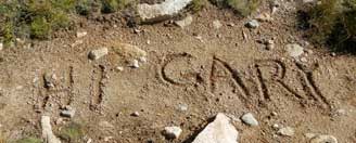
Left camp around 8:10. We made good time to Marjorie Lake. At Marjorie, Ray and Rachel left a"Hi Gary" on the trail. Makes me so happy. Then it is the start of our real climb up Pinchot Pass. We stop at 11,500' for  a break and a Clif bar. Again at 11,900' we stop and break-we have gotten awfully good with practicing these breaks. Saw Larry and Paul at one of the breaks on this climb.

Marjorie Lake
Marmot keeping watch
This is what I love about the High Sierras. The blue and green lakes and tarns, surrounded by mountains rising out of the earth to the sky. The far away peaks are a vision. As Sherri says, we have to work for this. Would I want it any other way? Would I love it if we whizzed by it in a car?

Made it to the top of Pinchot Pass a little before noon. This pass turned into a real party! Paul and Larry came up shortly after we arrive. Then three PCTers came up. Finally a lone JMTer arrived. After we all talked for awhile, found out the lone hiker was John B, from our meetup group in Fresno. Talked some on the way down. He is a professor at Fresno State and should be meeting Lori's group tomorrow at East Lake.

John B, Sherri and Gary on top of Pinchot Pass
Went down part way with John B. Then needed to stop. John went off on his way. But Larry and Paul catch up with us and we hop scotch with them down the trail, the rest of the way to Woods Creek. Earlier, my GPS ran out of batteries, so I lost about a mile of data. Also found out my iPad is not charging. Not sure why.

The way down after steep part of Pinchot is plain old long and hot-there is no cloud cover today to keep the sun from our skin. We actually pass Larry and Paul today-Sherri is listening to Fleetwood Mac. This certainly speeds things up our pace!

We stop at Sawmill Pass trail junction. Larry and Paul join us. Larry is having an issue with his iPad mini and it wanting him to backup to the iCloud-fat chance of this out here, or for the next week or so. We figure out how to do a reset by holding down the Sleep and Home keys for about ten seconds. Success.

Woods Creek
On our way down the last 3.9 miles, it seems like it goes on forever. In reality, it just drops 2000' in those miles. It is rocky and uncomfortable and just OK as far as beauty, at least compared to the rest of the Trail. Finally the Golden Gate of the Sierras brings us joy. In case you do not know what it it is, this bridge is a single person at a time, swaying suspension bridge across Woods Creek. A fun amusement park ride for those who like such things. A quarter of a mile later, we cross it, bringing us into one of those large congregation of JMT camps (36.87289, -118.43515)

Many others are camped here. Larry and Paul come in a little while later, at a camp a bit lower than ours. Both of us are tired and do not move very fast. But the tent gets put up after being aired out. Water is drawn and dinner is cooked. About the same time as we finish, Larry and Paul join us with their food. We talk and eat the rest of the evening. Larry loans me his battery pack and I get a charge on my iPad. By the time we get to bed, it is 9:20-no McGyver tonight.
Towards Rae Lakes and Glen Pass
 
Today's JMT Lesson:  You need to work to get to see beauty.


 Breakfast Lunch Dinner Snacks
Oatmeal and add-ins, such as dried peaches, strawberries, nuts, granola. Tang. Peanut Butter and Nutella on crackers Beef and Cabbage Wrap Clif Bar, Jelly Bellies, CytoMax, Propel, GORP, Bank Balls


 1The supplied figures above come from either the book John Muir Trail: The essential guide to hiking America's most famous trail by Elizabeth Wenk or from topo maps. There was only partial tracks for today in my GPS. Below is the readings from today's status on the GPS. I view it as only somewhat accurate.
Distance:  9.6 miles
Elevation Rise:  1,926'
Maximum Elevation: 12,130'


Marjorie Lake from Pinchot Pass
2Be Though My Vision
Naught be all else to me, save that Thou art
Thou my best Thought, by day or by night,
Waking or sleeping, Thy presence my light.

Be Thou my Wisdom, and Thou my true Word;
I ever with Thee and Thou with me, Lord;
Thou my great Father, I Thy true son;
Thou in me dwelling, and I with Thee one.

Be Thou my battle Shield, Sword for the fight;
Be Thou my Dignity, Thou my Delight;
Thou my soul’s Shelter, Thou my high Tower:
Raise Thou me heavenward, O Power of my power.

Riches I heed not, nor man’s empty praise,
Thou mine Inheritance, now and always:
Thou and Thou only, first in my heart,
High King of Heaven, my Treasure Thou art.

High King of Heaven, my victory won,
May I reach Heaven’s joys, O bright Heaven’s Sun!
Heart of my own heart, whatever befall,

Still be my Vision, O Ruler of all.

Heading towards Woods Creek


Heading towards Pinchot


South from Pinchot Pass


Falls on Woods Creek


Wednesday, January 14, 1970

Place: CA-Sawmill Pass

Sawmill Pass (quad)
(Long, Lat)

Description:
James W. Smith had a sawmill on this creek in the ’70s. The pass was crossed in 1878 by Frank M. Lewis, who had examined it from the west in 1875. (Chester Versteeg.)   from Place Names of the High Sierra (1926) by Francis P. Farquhar

Trips:


Pictures:


References:
  •