Showing posts with label Tablelands. Show all posts

Thursday, October 3, 2019

October 3, 2019 - Park Ridge Lookout


Title: October 3, 2019 - Park Ridge Lookout
Hike Info : DescriptionAnimals 
Trail head: Park Ridge Lookout
Hike Info:
Smoke from the Sherman Prescribed Burn
Type: Lookout

Description:
Today I felt should be called my personnel Lookout Appreciation Day. At least by the end of the day, I felt that way.
I got up a round 0530, a bit earlier than I wanted to, but not too bad. Got ready and packed my truck after having breakfast. I left my house at 0655 and got to the Grant Grove Visitor Center about 0810. A good drive up. I talked with some of the Visitor Center people. I think they are starting to recognize my face. We chatted for about 10 minutes. A volunteer there lives in Wilsonia and is grateful we are up at Park Ridge and able to look down at her house-she feels protected. Another lady who works for NPS said that she appreciated the work we do up there. One of the lookouts spotted the Dry Creek Fire which left unchecked, her house would have been right in its path. I love my volunteer gig. Then it is off to my place today.
Looking West from Park Ridge Lookout
Smoke penetrating the Lake Kaweah area
It is the same drive up to Park Ridge Lookout I took Tuesday. The gate going up Panorama Pt is closed, but I can get through. No traffic on the road-that is the most scary part of the whole drive usually. It is a narrow road and sometimes you get drivers who lack caution. So that is a nice thing about the road being closed, almost a guarantee of no traffic. I get to the lookout at 0855. There are a few spider webs on the stairway. Amazing how fast those things can spin. I get set up in plenty of time. While taking the weather, I also talked with Sherri. She and Steven are thinking about going hiking today. Just confirming that Pan Pt is closed.
At 0929 I go into service. SEKI weather hits right after I go into service. Today I get staffing down-pretty easy. All are working on the Sherman Rx. Speaking of Sherman, lots of smoke to my south. Looks like it goes from up in the Tablelands all the way down to Lake Kaweah.
I settle into the routine of doing scans, listening to the radio. Nothing dramatic. Just enjoying that it is 15 degrees warmer than Tuesday. Still not terribly warm, but it is pleasant. The morning is clear, so I spend some time looking over the front country. Yesterday there was a fire called the Sesame Fire, near Miramonte. I spend some time identifying what is around there. We could not see the location itself as it is behind Indian Hill. Still, we probably could see the smoke for a bit over the top of the ridge.
I talked with Sherri some. She and Steven are coming up. I had heard at 1030 that the Pan Pt road was going to open. So I relayed that on to them. If it is, then they will hike into Park Ridge. When they get to Grant Grove, the Visitor Center said that it was still closed. They would see if it is. If so, they will figure out someplace else to hike at.
The glint I saw.
In the late morning sun, I saw a glint of parked cars beyond Wilsonia. I tried to get a good read on where it is. Most of the time they are hidden. I think they are someplace between the Visitor Center and the tent cabins, but they could be beyond the gift shop. None of the azimuths line up though with the fire finder’s azimuth of 315 degrees, 49’. So it will be a puzzlement. (At the end of my shift, I stopped by the front of the gift shop. Park Ridge Lookout was not in sight-too many trees. But it would be the right area, I think with the green roof. It is the only large green roof I saw among the village.)
1230-Lunch time. The usual of a peanut butter and Nutella sandwich with some chips. Still tastes good.


Sherri approaching the lookout


I got visitors! A couple from Los Angeles, then a person from Atlanta. Talked with them for awhile. They seemed interested in how the fire finder works. They also expressed appreciation that someone was up here keeping watch. After they leave, I do a couple scans. Then Steven and Sherri come up, having hiked in. We talked for about half an hour, partly explaining to Steven how things work, partly just enjoying the company. They leave about 1500 and I am back to normal activities. (As a note: Sherri met the husband on the way out of the couple. He was excited to learn about things in the lookout, especially the fire finder-he is an engineer in real life.)


Porterville reported that there were three tankers leaving for an MMU incident. This is a CalFire unit which services Madera and Mariposa counties. This must be serious to have this kind of response. But it is well outside of anything which I would report.
Evening sun on the way home
All afternoon the radio was scratchy coming out of Porterville. It was like this once before back in July. But what rang out loud and clear was three buzzer sounds. That is our signal that an incident is being rung out. I pray, don’t let it happen in my area as I do not want to have missed a fire here. But then they say this is a Freeman incident, with units being called out in the south. Whew, I did not miss a smoke. But evidently both Buck Rock and Delilah had too much static to get even what I got. So I hear them talking on R5 and neither of them picked up on the location. I have a list of places and how far they are from the lookouts. Freeman Canyon is 96 miles from Park Ridge, well outside of the viewing range.
My radio troubles continue. I thought I had changed the channel to R5 on the base radio. But the knob is a bit finicky. After I tried to raise Buck Rock, I saw that it was on a different channel. By that time Buck Rock was trying to reach me. Oh well. I told her what I knew, even though I think she wanted a bit more info, but I did not have it.


Deer guarding my exit
So ends the excitement for the day. More scans more radio listening until 1800. I go out of service and pack to go home. I got a thanks from Wendy-so ends my personnel Lookout Appreciation Day. Sherri and Steven wonder if I want to have dinner with them. Yes, but I will not be home until 1945 at the earliest. They are willing to wait. So we had a late dinner at DiCicco’s in Clovis. Tired and content.

Animals


Wednesday, August 17, 2016

August 17, 2016 - Wolverton to Heather Lake and the Watchtower


Title:August 17, 2016 - Wolverton to Heather Lake and the Watchtower
Hike Info : Description : Trail Lessons : Background Extra Photo's Flowers and Plants


Trail head: Wolverton
Hike Info:
Type:  Hiking
Trail: Lakes Trail including The Hump and The Watchtower trails
Destination: Heather Lake and the Watchtower
Distance:  8.00 miles
Start Time: 11:02
End Time:   6:42
Travel Time:  7:39 (1.05 mph)
Moving Time:  4:43 (1.70 mph)
Elevation Rise: 2,070'
Maximum Elevation:9,434'


Description:
This one started as an overnight trip to Pear Lake, then a day trip up to Pear Lake. Now it is lets see how far we can go and just enjoy the day out.

Sherri at the start of the trail
By the time we leave Fresno, it is close to 9:30 and we get to Wolverton a little before 11. Sherri takes off. But I stop and talk with a backpacker from Carlsbad. He has a "Take A Hike" T-Shirt which features the three Sierra National Parks: Yosemite, Kings Canyon and Sequoia. He has hit the trail in all three of these and will return back to teaching next week. But he had a grand time. We talk about different places. He mentions the Lost Coast and I tell him it is on  my list of hikes to do.

After talking for 15 minutes, it it time to rejoin Sherri. But she has stopped only a hundred yards up the trail, waiting for me. Foolish woman! You would think that after close to 40 years she would know how long I could chat with someone?

The thing about this trail is that it is a long and grinding uphill. The trail is not content just to defeat you, but to pulverize you into trail dust. So why do it? Because you know there is rewards to those who preserver. Sort of like life you know, just because there is pain and suffering, is the end result is worth it, you continue to endure. If not, you look for an alternative.

We eat lunch at the Panther Gap trail junction. I also am testing out our SPOT device. It did not function reliably during our abbreviated JMT trip. During lunch, a couple of young women came up-Nikki and Sonya.  They are from Fresno and this is a different Sonya than the one we usually hike with. We talk for a while and then they leave right before we do.

The Hump trail is about a quarter mile from our lunch break and that is the trail we take. It is used during the Spring and until the Watchtower trail is safe from ice. But the disadvantage is that it does go a couple hundred feet higher than going via the Watchtower. Also this is not a trail of grand vistas but through the woods. Also there is no downhill on it. It is all up. And that is what we do, climb to the top of the Hump, and there we start to get our reward.
Looking North From the Hump
Gary enjoying the view
At the top, we stop for a break. Or do we stop to gawk? Either way it was time for a rest. And if our resting spot gave us a view, who am I to complain? From our vantage point, we can see across into the Tablelands. This is a treeless area at the headwaters of the Topakah Creek. No trails go through there, but it is a favorite cross-country route for many people. Another test of one of our SPOT devices.

Then we drop down a couple hundred feet and join the Watchtower trail to Heather Lake. There we met some hikers. One has a good nature comment of, you are close, you are almost there. I apologized in advance and replied I was going to get metaphysical on him by asking "What does he mean 'almost there'? I prefer to think that I am here." He replied that he really liked my comment.

Gary heading towards Heather Lake


But my new friend was right, we made it to Heather Lake in just a steps. While Sherri went off to visit Nature, I stayed by the lake. Our now old friends, Sonya and Nikki then strolled up. We talked for a good length of time while relaxing by the lake. Nothing deep, just friendly. But then it was time to leave.

About this time, we raise the question, have we told Steven, our son who is taking care of my Mom, that we are out hiking? We think so, but cannot think of a specific conversation. Will try to reach him on the way down.


Heather Lake
Gary on the Watchtower Trail
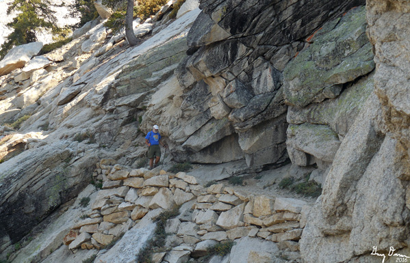
Instead of coming back via the Hump, we will take the more scenic route of The Watchtower. This trail is cut into a cliff, giving a great view of the Tablelands and the Tokopah Canyon area. But it is not for those with vertigo or a concern for falling. One slip and you will have a one way flight to the bottom, maybe a thousand feet down. On the other hand, bring your camera since each step you take presents new opportunities for pictures of the oooh and ahhh quality.


View from the Watchtower Trail


Sherri looking across the Tokopah Canyon

The Watchtower

By the time we reach the Watchtower, it is pretty late. So we do only a brief stop and gawk. Enough to take a few pictures and then move on. It is about 3 miles back to the car and mostly downhill. We meet an older couple who are struggling a bit. but who are taking a small break. They comment about how hard this trip is. Hard yes, but not too bad for those in shape-I only think it, not say it. Am I getting wiser in my old age?

By the time we make it back to the car, the shadows are getting long and I have not been able to reach Steven to confirm that he is taking care of my Mom. I do a final test of the SPOT and place it on top of the car. We decide to see if the Lodgepole cafe is open. It is and we have a hamburger. Sherri calls Steven and finds out, no we have not told him we went hiking. But an intelligent son that he is, he has deduced it. As we pass by Squaw Valley, I hear a thump off of the car, and nothing else. We continue on. By the time we get home, it is after 9pm and we are tired.


Trail Lesson:
Being "here" is much better than even being "almost there."


Background
We have two SPOT devices: SPOT Satellite GPS Messenger (Ritto) and a SPOT Connect (Shirley). The devices are named after our pets. In the past they have worked OK, with  80-90% success. But during our JMT walk, Ritto only connected once out of the three nights. So this hike, I wanted to test it out. Below is the results-it is an e-mail I sent my brother. I also sent the contents of the e-mail to the SPOT people.
I am not sure if I have an endorsement of the SPOT or throw it away decision. After our aborted JMT attempt and getting only one out of three signals to be received, I have been trying to get the SPOT Messanger to work. First the endorsement:

We had come back from our hike out of Wolverton in Sequoia NP. I wanted to get one last "OK" message sent. So in the parking lot I set off the "OK" message and set it on top of the car to transmit. It actually did transmit. I also had Tracks on.  But as you might have guessed, I forgot the SPOT on top of the roof. As i am driving home last night, I hear a clink on the roof, but not sure what it is-this happened just outside of Squaw Valley. I get home, do not find the SPOT device. So before going to bed, I look at the SPOT map and there it is at the corner of Lovewell and Hwy 180. I get up this morning and there is a ton of tracks at that location. This morning I drove back out there and was able to recover the device.

So why am I about to throw it away?
1) When out on the trail, two out of three OK messages were not received.
2) Last Saturday I walked around my neighborhood with Tracks on and with trying the OK button a couple of times-55 minutes. Not one was received.
3) Yesterday I set on TRACKS at the start of our hike, around 11am. We finished up a little before 7pm. I pressed OK three times. I got one of them. The first two times was once at lunch around 12:30; the second when we stopped for a rest at the top of the Pear Lake Hump. Both times we were stationary about 20-30 minutes. The one time it did show was the one which I left the SPOT on top of the car. The TRACKS on the trail was only a little bit better. I had six tracks left between 2:30pm and 4:40pm. One wonders what happened to the tracks between 11am and 2:30 and the those between 4:40 and 6:45pm.

While I will not "throw it away", until I understand better why it is not reliable, it will not be relied upon. Sounds like a support call.
On a recent backpack trip I got three out of four messages from "Ritto" and three out of five from Shirley. SPOT support has offered a discount on a new SPOT. But then I also got a notice that SPOT is raising their service fee by about 33%. So I am not sure I will renew. I have a month to think about it.

Extra Photo's
Up the Tokopah Valley
Trail View looking west

Alta Peak on the Right
Trail Through Two Trees


Flowers and Plants


Wednesday, July 30, 2014

July 30, 2014 - Watchtower and Tokopah Falls

Tablelands
Title: July 30, 2014 - Watchtower and Tokopah Falls
 Trail head: Wolverton Parking Lot
Hike Info:
Type:  Hiking
Trail: Lakes Trail
Destination: Watchtower
Distance: 6.59 miles
Start Time:  8:29
End Time:   1:24
Travel Time: 4:55 (1.34 mph)
Moving Time: 3:48 (1.73 mph)
Elevation Rise: 1,972'
Maximum Elevation: 8,910'


Description:
When I think of a hike up to the Watchtower, I think of a good climb through forests and then a single place to find a sight worth the climb. But today, I got all of that and more.

I started the morning by stepping outside and immediately decided to go back inside. The sky was dark and clouds were ominous. So I went back inside to get my rain jacket. Now I am prepared, I think. On the drive to Kohl's, saw a couple flashes of lightening-well, maybe not all that prepared.  At Kohl's, picked up Brian W and went ahead to load Bill and Richard on the way. Even driving up, we saw lightening flashing from the clouds down to earth. There was a few drops of water hitting my windshield. After a break at Big Stump, we traveled on to the Wolverton parking lot, the beginning of our hike.


Cathey and Audrey walking through meadow
This hike is nearly a consistent uphill coming in. We start with a good climb out of the parking lot until we meet the ridge overlooking Lodgepole. The word overlooking is a bit of an exaggeration as the view into the Tokopah Valley is mostly obstructed by trees. But that is OK since the trees have a tendency to keep this trail cool and are enjoyable to walk through, even in bright sunshine. But today, it is overcast with a bit of concern about rain, not that the rain ever shows up.
Now the more  from above is this: surprisingly there are flowers presenting themselves, particularly in the meadows. Not so much surprising that there are flowers here, but that there are flowers here now, with as little water as we have had this year. There are some Columbines and Indian Paintbrushes. But also several varieties of whites and yellows, with blues. Just an eye opening time. There is more to this trail than just the Watchtower.

Across from the Watchtower

We reach the junction with the Panther Gap Trail-the same one we walked with the meetup group in mid-June. But we take a left, and shortly ignore the cross-over Hump Trail to Heather Lake. The rise is still moving us upward, but not as steep, until right before the Watchtower.
Once we climb a few switchbacks, the Tablelands open up for us. This is the area beyond the Watchtower in the upper Tokopah drainage.  Just an amazingly inviting country. Sherri and I have done Pear and Moose Lakes. But the area beyond is calling me. We can see across to Silliman Crest and that area. 
Tablelands
Watchtower cliff


John
The Watchtower is a place just to rest and cogitate, but not if you have vertigo. The trail brings you to the edge of a 1,100' drop straight down. Most of us enjoy the view, but from a distance at least six feet from the edge. The actual Watchtower is about a hundred feet across a chasm. Some of our group go around and climb up it and enjoy that sight.
Now it is time to return back to the cars for more fun. The return trip is backtracking along the trail we just came up. For some reason, it is easier to return going down. But somehow I am now feeling more tired. We get down just five hours after starting. Time for another walk, but this time gentler.


Trail head: Lodgepole Campground
Hike Info:
Type:  Hiking
Trail:  Tokopah Falls Trail
Destination:   Tokopah Falls
Distance:  4.01 miles
Start Time:   1:46
End Time:     4:16
Travel Time: 2:30 (1.60 mph)
Moving Time: 2:08 (1.88 mph)
Elevation Rise: 502'
Maximum Elevation: 7,155'
The Watchtower

Description:
For the second part of the day, we scurry over to the Lodgepole Campground. There is a trail head inside the campground. So we park on the south side of the Marble Fork of the Kaweah River, cross the bridge. The entrance to the trail is just beyond the bridge on the north side. In case this sounds familiar, our meetup group did a hike in March to some falls on this fork.
The trail is gentle, at least compared to the Watchtower.  So this does allow for conversations to occur, rather than the gasping for breath which happens on high altitude climbs. So I walk with a couple others and get into a conversation with Audrey, a third grade teacher with FUSD. Just a pleasant time to chat about people whom we both know.
Tokopah Falls, or trickle


Marble Fork of the Kaweah
But back to the trail. Towards the Falls, we get into granite blocks which we climb through. We come out to the trail's end, where the falls are. Or I should say, where the falls should be. But now there is only a trickle coming down. Sort of a disappointment in the falls. But as John said, you can just imagine how beautiful they would be-he is ever the optimist! People start to leave and I walk back with John and Cathey.
Bear Cub
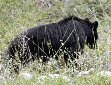
The hike back is on the same trail. But it amazes me to see how different the same dirt can be going in a different direction. Just the trees and the creek and looking down valley have a different perspective. And a bear cub gently grazing for his huckleberries. Wait! A bear you say? Well really a cub about 30' from the trail. Several of us, and others, stop to gawk and take pictures. I was told that after I left mama and and another cub came up.
Grouse
Not much more after that, except for a grouse posing for a picture. We get back to the trail head and the car. Our car decides to continue back to Fresno rather than stopping for a bite to eat. I get back to home around 5:30.


Trail Lesson:
Prepare to enjoy the beauty you do not expect.


Tuesday, January 20, 1970

Place: CA-Tablelands


Tablelands (Lodgepole)   
(long, lat)

Description:


Trips:


References:
Pictures: