Showing posts with label Galen Clark. Show all posts

Tuesday, November 11, 2025

November 11, 2025 - The Other Wawona Loop


Title: November 11, 2025 - The Other Wawona Loop
Hike Info : Description : Extra Photo's : Flowers and Plants


Hike Info:

Type: Hiking 

Trail head: Wawona Visitor Center Parking Lot

Trail:  Chowchilla Mountain Road, Four Mile Road, Part of the Bills Hill Trail, Wawona Meadow Loop

Destination: Loop

Distance:  6.45 miles

Start Time: 12:17

End Time:     4:47

Travel Time: 4:30  (1.43 mph)

Moving Time: 3:47   (1.71 mph)

Elevation Rise:  1,121'

Descent: 1,102‘

Maximum Elevation: 4,839'

GPS Tracks


Description:

I got up at 5:30. Today we are going to do a hike up at Wawona. Unlike a couple of weeks ago, we will be doing an extended loop around Wawaona Meadows. But first, I have a 9:00am appointment with my dental hygienists. I worked on my book blog-we are having the author of Consummation for my Book Group Thursday and I need to be prepared for it. The hygienist visit went well. I think this was the first time ever that I was told I am doing well with my flossing.

I get home at 10:10. Rachel comes in shortly afterwards. Steven will not be coming with us. We are able to leave by 10:40 with me driving. It is Veteran’s Day. So I cannot understand this long line of cars heading south on Highway 41. I am just glad we are heading north. We arrived at the Wawona Visitor Center parking area a few minutes before noon. Coming in we had noticed what looks like a prescribed burn a little ways away from Wawona. When we get out of the car, there is a slight smell of smoke. After discussing it, we felt it does not seem to be too bad. So off we will go on our hike.

At 12:15 we started walking up the Chowchilla Mountain Road, but only about ¾ of a mile up. Tthis part of the trip is where we gain most of the elevation. It is huff and puff time for my part. We did not go on the first junction, but the second junction to the Four Mile Road. This second one is a bit overgrown from disuse. Maybe it would have been better to have taken the first junction.


One of the things which I like walking the Four Mile Road happens right at the apex of the triangle between the three roads. There is a tree which stands right in the center of the two roads. In the Autumn, this whole section is covered with leaves, forming a carpet of brown for us to walk on. The trail now does a series of undulations as it climbs its way across
Mt Savage-you have to go either cross-country or find a use trail to go to the top.

As we walk along the Four Mile Road-not the Four Mile Trail, it gives us a chance to talk. The subject of meditation is brought up. Particularly when walking or hiking. We discuss the various aspects of being able to meditate. There seems to be an element of calming your physical body or at least getting in a rhythm where you do not have to think about what the body will do. But there is also an element of letting your mind rest. Silence is part of this. When walking alone, you only get the sounds of nature-the birds, the wind, the crunching of your feet against the ground and sometimes the little trickle of water running down a hillside. These work to calm and help you to focus your mind on the subject of your meditation. In a Christian it is God. In the outdoors, I usually think about God, the Creator and the God who loves me.

Eventually we decide we want to stop and have a bite to eat as it is around 1:40. We spot a nice log about 15 feet above us and we scramble to it. It is a nice log just to set and eat at. I do notice there are some fungi growing under the log.


 About ten minutes later, we came to the trail junction down to Wawona Meadow. Something has changed-there is a sign. The first time we walked this, there was a barely noticeable indentation in the mountain misery to guide us where the trail was. Over the years, a bit of flagging was added to a metal pole. Now, the whole world knows where to turn. What fun is that?

This is a little used trail which I think is part of the Bills Hill Trail. I think it is one of the more enjoyable trails in the Wawona area. We see very few people on it-today the number is less than one. It takes you down from the Four Mile Road to Wawona Meadow. There has been trail work down on it as the downed trees which we used to crawl over have been sawed recently. I have never gone up it, but I think it would tax a person who is in shape, which I am not. But coming down, we see all sorts of trees and brush. Towards the bottom we run into the power lines which come into Wawona. And then there is the service road which goes up to the lower poles. The trail repeatedly crosses this road-you can take the shorter route, but the road is steep.


When we come out on the Wawona Meadow Loop, we find the log which we rested on a couple of weeks ago and eat an energy bar. I give Sherri and Rachel a choice: continue on the Bills Hill Trail up to the top of the ridge to the east of the Meadow, or follow the Loop trail around the rest of the meadow. The choice is to do the Loop Trail. That probably is wise.

Walking the Wawona Meadow Loop trail is comparatively faster than going up either of the roads. Still we found plenty of occasions to stop and take pictures while enjoying the company of each other.

Gary
The Meadow has some very historical aspects to it. Such as tucked away in some trees is the site of Galen Clark’s Inn. Or there was once a landing strip in the meadow. Or there were orchards to supply fresh fruit for guests. It is the last item which has a bearing. The Washburns ran a flume from the South Fork of the Merced over to the Meadow. You can still see the flume and where it drained onto the meadow. It has been one of my fascinations to walk the bank of the flume on the over side of Highway 41 around until we are above the hotel. So endeavored to do that. Rachel decides this type of adventuring is not for her and retreats back to the trail. I think Sherri is doing the same thing.  


Walking the Flume is Blocked
I try to walk the flume. It has gotten a lot more overgrown since I last walked it before the Pandemic. I detour around part of it. Then bushwack through other parts until I reach a solid wall of young pines. I know when I have been beaten and descend down a steep slope to the trail. I eventually come across Rachel waiting patiently on a log for me. I asked her, “Where is your mother?” “She is following you.” Oh Oh. So we took off looking for her. We were yelling her name and then we heard a response, and then had visual of Sherri. I need to back up a bit. Sherri is coming down the area which I did. When I came through, I noticed a telephone line just about 4½’ off the ground. Since I was lumbering along, I ducked under it. Sherri on the other hand makes a bee line straight for Rachel, not stopping for the line in her path and gets clotheslined, just like in the cartoons. If I was more sensitive, my first response would have been to run over and see if she is OK. But from the way Rachel and I are laughing, you would think this was the funniest thing to have ever happened on earth. After we stoped laughing, we checked on Sherri’s well-being-nothing damaged except for her ego.


Even with this mishap, we are only a short walk back to our car. We get back as the skies are darkening, as this time of year that would be 4:45. Rachel takes up the driving responsibilities. We decided that we wanted to eat before reaching Fresno. I suggested Mexican, to which there were no objections. We decided we wanted to eat at our new restaurant-at least new to us-
Los 2 Carnales.

We get home at 7, just in time for watching Jeopardy. Rachel watches it with us. At the end, she goes home and I go to the shower.


Extra Photo's


Wawona Meadow

Four Mile Road

Tree roots by the road side

Four Mile Road covered with pine needles

Autumn Colors

Rachel and Gary on the Four Mile Road


Red Leaf

Sherri and Rachel walking the Bills Hill Trail

Rachel and Sherri  walking the Bills Hill Trail

Rachel consulting Mr Garmin

Light and Tree

Christmas tree

Walking the Flume-what was bushwacked through


Flowers and Plants

Phlox


PuffBall

PuffBall

Shelf Fungus

Mushroom


Saturday, January 11, 2020

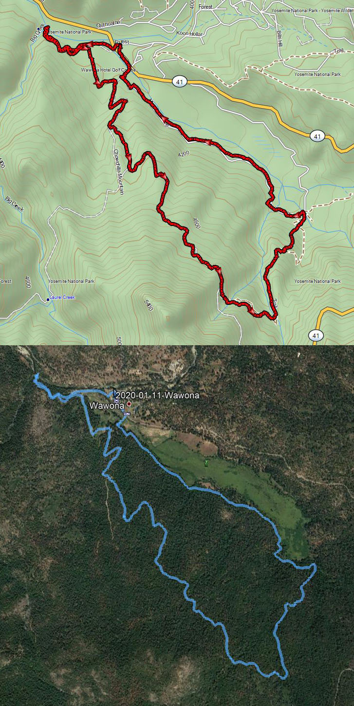
January 11, 2020 - Wawona


Title: January 11, 2020 - Wawona
Hike Info : Description : Background :  Extra Photo's :  Flowers and Plants

Trail head: Wawona Parking Lot
Hike Info:
Type: Hiking
Trail: Wawona Meadow, Raymond Road, Old Trail to Big Creek
Destination: Loop
Distance:  6.97 miles
Start Time: 1:21
End Time:  5:15
Travel Time:  3:53 (1.80 mph)
Moving Time:  3:30  (1.99 mph)
Elevation Rise:  1,246'
Descent: 1,056‘
Maximum Elevation: 4,837'

Description:
I got up this morning not knowing what we might do or where we might go. Do we stay home and continue cleaning? Does not sound fun. Is fun the only criteria that there is? Snowshoe? Snow levels seems to be high, so the concentration of people will be pretty dense. How about hiking? Sounds interesting. Where? How about Wawona? Let's go!
We left Fresno after 11 and arrived a little before 1 at Wawona. In Oakhurst we changed drivers. We asked on entry into Yosemite about snow at Mariposa Grove. The ranger said there was snow at the Grove, but not lower. Does not sound too good for hiking. Maybe up to the Grove but not in the grove. So down to the meadow.
South Fork of the Merced River
Before we started hiking, we ate lunch. That is a peanut butter and Nutella sandwich. Over the years, we have developed an extended route around Wawona Meadow. Now to see how much we want to do of it. Actually, we have never done the extended route all in one hike, just in parts.

South Fork of the Merced River
We get our backpacks on and cross Highway 41. But instead of doing the trail which bi-sects the golf course, we go on the north end of the course, which takes us by the golf pro’s shop, which used to be the place where the butcher did his work for the Wawona Hotel. After rounding the building, we head towards Big Creek. It is a nice, third of mile walk through lots of young trees. We enjoy the flow of Big Creek as it enters the South Fork of the Merced River. Ice has formed in the river, where the flow has not quite knocked it down. We look around a bit, but do not go over where the pond was-too much snow and do not want to slip.
We retreat back the way we came until we come to the old smokehouse. Then we skirt the western edge of the golf course. Normally we pay a visit to the site of Galen Clark’s cabin, but it probably is a little bit too mushy, so we stick to the road which loops over to the Raymond Road. We feel that after Pincushion earlier in the week, this road should be acceptable to us. So up we go. I am doing OK, even though I am glad I do not have an overnight pack on. The road is pretty firm and we do not have any problems sliding or anything with it. In places there is a layer of frost, but nothing bad.
Sherri on the Mt Savage Road

We hit the crossover road. I have speculated that originally this might have been the entrance road to the park since it comes out right where the guard stations are. But I have not seen anything which confirms my speculation. By the way, from what I can find, the road is called the Mt Savage Road.
Walking is a good way to think and talk. The most pressing thing we have to think about during the next several months is what to do about an estate plan. So that is a topic of discussion. It is obvious we have a difference of opinion on certain matters, but that is why one talks, to see where you have agreement and find places where we can agree. We will continue to talk in the coming days and weeks.
Gary going back down to Wawona Meadow
I am looking for a stake and a trail to go down to Wawona Meadow. I see the stake, but Sherri keeps going. But not for long. The trail down to Wawona Meadows is narrow, surrounded by mountain misery for a long ways. Today it has a layer of snow-not much, but enough to be careful on how one walks. It is a pleasant route, but the one I am glad we are going down. At one place, we miss a turn and go down a very steep service road. I know that it all goes to the same place. Still, it is very steep.
When we reach the trail which loops around Wawona Meadow, we have a choice-left or right, clockwise or counter-clockwise? Normally we would go counter-clockwise and maybe even walk the flume. But it is cold and there are two creeks which we would need to cross. So we go clock-wise. The walking is much faster, but the light is fading. We make it back to the car before dark and even got glimpses of the sun leaving the ridges to our east.
Now that we are back in the car, snuggly and warm, the big decision has to be made. Where to eat? We decide on DiCicco’s in Oakhurst. Not a lot to say,except that it was a good choice. Had exactly what was needed to fill my body. Then it is back to Fresno and a nice hot shower.


Background
See the Wawona page for some of the things talked about on this page.


Extra Photo's

Confluence of the Merced River and Big Creek

Gary
Leaves under snow

The road we did not travel

South Fork of the Merced River
Sherri on the trail down to Wawona

Clouds on ridge to the east

Sky ablaze

Sunlight and clouds

More sunlight and clouds

Looking towards Mariposa Grove


Flowers and Plants